SnowenOutThere
-
Posts
5,666 -
Joined
-
Last visited
Content Type
Profiles
Blogs
Forums
American Weather
Media Demo
Store
Gallery
Everything posted by SnowenOutThere
-
Rough cutoff over western fairfax county today. I’m sitting just under .3 while under a mile away is 1 inch plus. Suns now fighting to come out, hoping we still got a batch or two of rain left.
-

2026 Mid-Atlantic Severe Storm General Discussion
SnowenOutThere replied to Kmlwx's topic in Mid Atlantic
SPC mesoanalysis shows a tongue of moisture streaming directly off the Atlantic from South Carolina. Thanks to insane dew points our cape values are at 2500+. Vis sat shows some clearing behind the current line moving through which might act as a bit of an instigator too. Almost feels like a tropical system with the rotating bands of showers forming from the south. Interestingly, the low level shear also is somewhat reminiscent of a tropical cyclone.- 1,707 replies
-
- 1
-

-
- severe
- thunderstorms
- (and 7 more)
-
2026 Mid-Atlantic Severe Storm General Discussion
SnowenOutThere replied to Kmlwx's topic in Mid Atlantic
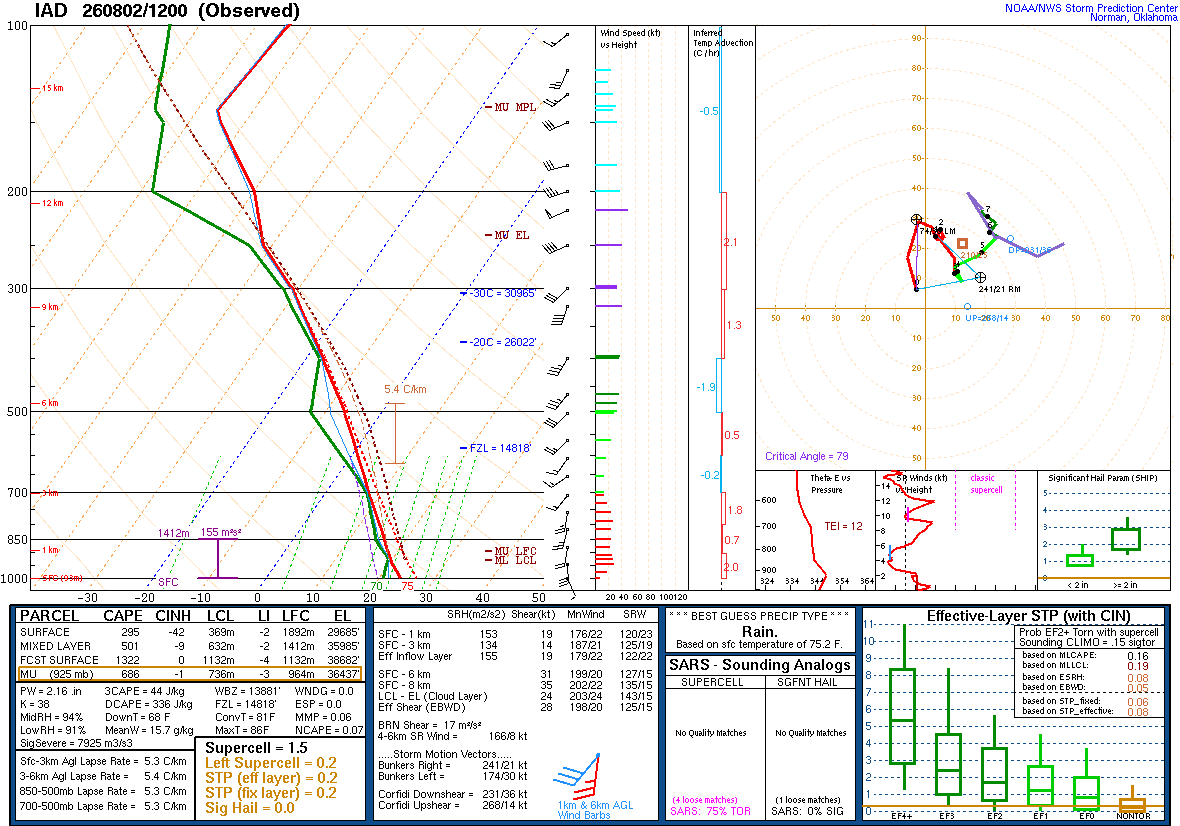
The 12z sounding from IAD seems pretty juiced. Nearly saturated atmosphere all the way up. I think the most interesting thing is how convective temp is only 81 degrees.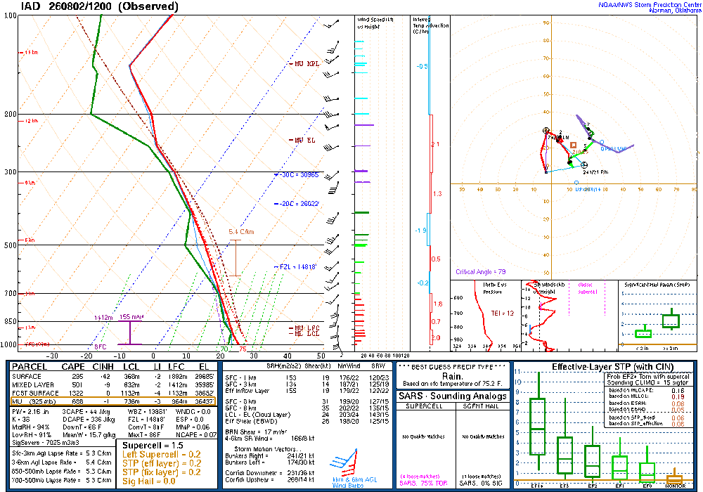
- 1,707 replies
-
- 1
-
-
- severe
- thunderstorms
- (and 7 more)
-
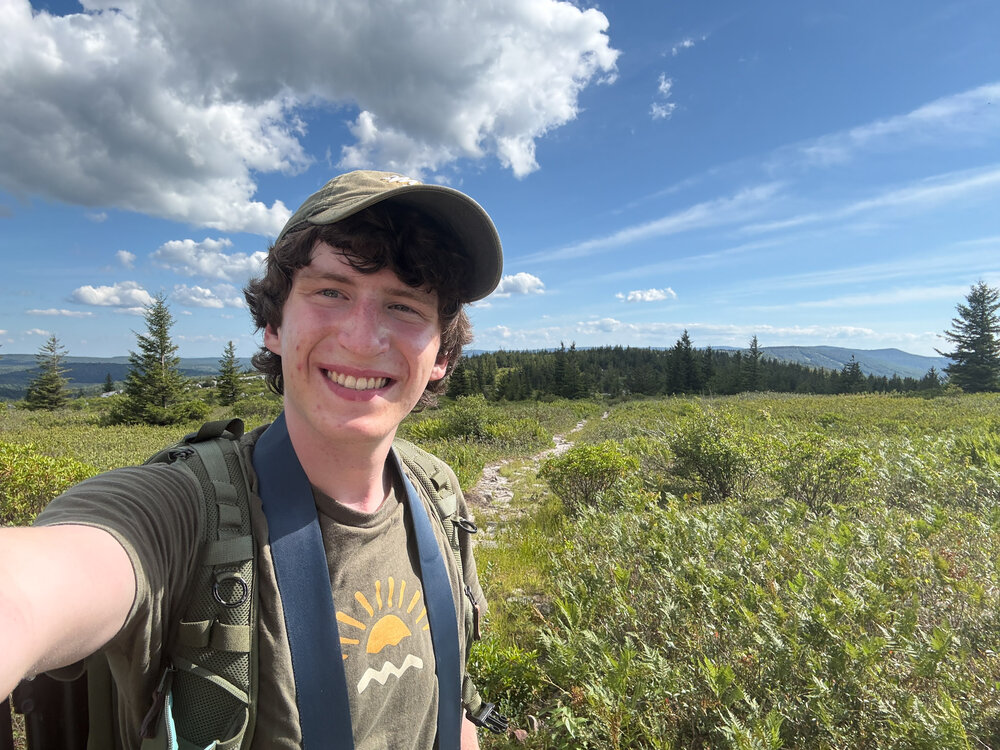
If you need a taste of fall head out to Dolly Sods WV! I went today (I guess yesterday now) and it always amazes me how the Allegheny Front is just a different climate. Drove up from the valley at 82 degrees to the top at 70 degrees. Went on a 12 mile hike and the landscape was beautiful, reminded me of tundra shrubbery I learned about last year in an arctic ecology course. Crossed Red Creek and entered the mud flats for 1 mile which was a bit rough. Otherwise, nearly a perfect day, and would recommend without reservations! (just skip the end of dobbins grade trail and take ravens ridge instead) Driving wasn’t too bad either, 2 hours 35 minutes and the vast majority of it was 4 lane highways (even in WV!). I’ll upload my other pictures later, but here’s one from my phone!
- 91 replies
-
- 22
-
-

-

-
I'll be joining your ranks tomorrow for a day trip to the Dolly Sods wilderness! I've hiked a bit of Red River in the winter but had to turn back due to the stream crossing. Now I plan to explore the upper marsh/meadow area.
-
I think theres a core issue here with Tor warnings in general. That being, even if there is a TOR, only a very small area of the warning will be actively impacted by the TOR itself. In that regard nearly every TOR warning is an "overwarning" as most of the square mileage of the warning won't be directly affected. For that reason, I think its fine to issue TOR warnings when the radar shows support one may develop as they are meant to be a predictor of a high chance one may occur. If the public fatigued its because they don't understand how warnings work in general. Therefore, the solution isn't to start underwarning but to educate people.
-
Fairfax county is an absolute embarrassment on that map.
-
2026 Mid-Atlantic Severe Storm General Discussion
SnowenOutThere replied to Kmlwx's topic in Mid Atlantic
The Fairfax county split is pretty pronounced today. Hoping the storms near Winchester can rotate in? -
2026 Mid-Atlantic Severe Storm General Discussion
SnowenOutThere replied to Kmlwx's topic in Mid Atlantic
They seem to have a bit of a severe shape to them. Not as extreme as last week when we had better hodographs, but still a good warm sector flow with some organization. The main thing I like seeing is the line of storms swinging into MD starting to fill in a bit more. -
2026 Mid-Atlantic Severe Storm General Discussion
SnowenOutThere replied to Kmlwx's topic in Mid Atlantic
I like that implies we will get upstream storms, so at the very least we should get a nice rainy/thundery evening from whatever remnants can make it our way. Sort of similar to our last setup and getting the MCS from WV. -
I went to backwater falls last January and it was pretty nice. The “trail” is pretty much a straight walkway down to the falls and there’s some pretty nice photography to be done there. I ditched and just did a long exposure of the water/ice in the snow as the lighting was bad when I went. It’ll probably be crowded, there were several families there even in the dead of winter, so that sorta sucked. Worth a small detour, but I personally loved the red river area far more and plan to go back sometime this or next week (and chimney rocks looks sick, but that’s further from deep creek).
-
2026 Mid-Atlantic Severe Storm General Discussion
SnowenOutThere replied to Kmlwx's topic in Mid Atlantic
Can see the clearing happening everywhere around my house on Sat, but ground truth is still cloudy with some haze. That said, think we could be in for a decent severe wx day, we got the parameters for a good squall/MCS so maybe we get lucky and have a nice shelf cloud.- 1,707 replies
-
- 2
-
-
- severe
- thunderstorms
- (and 7 more)
-
You know more than me of course, but I have to think we’re seeing the pattern shift happening. We’ve now had a string of strong lows move by to our north, which if it wasn’t mid summer and the thermal boundary wasn’t up in Canada they would be our synoptic rainfalls instead of convection along the cold front. Now this week looks to have a cutoff low over the northeast that dumps rain too. We still might have some dry periods but it seems, to me at least, the real drought period is over.
-
Man, the silver line extends out to Reston for a reason. You’d get a whole 30 minutes to maybe even an hour of more snow before the flip to rain in our warmer 2016 redux.
-
Took advantage of the excellent weather yesterday to hike sky meadows. Only an hour ride from NOVA and nearly a straight shot on 66 West. Wasn't expecting too much, but was blown away by the views it offered. Highly recommend to anyone wanting to go on a relatively easy escape into nature. Best part of course was the weather. Mid to low 70s in the forest with nice dewpoints too. Also had the moon as nice friend the whole hike!
-
Beautiful morning out. On ffx county parkway where it overpasses 50 could finally see past the blue ridge way to the distant mountains. Otherwise, mid 60s and low humidity means I get to wear a jacket today to coach!
-
Not enough people are talking about the legendary stretch of weather coming up from tomorrow till Saturday. Highs barely past 80 degrees and dewpoints in the low to mid 50s in MID JULY. It’ll be the first look ahead to fall weather wise!
-
2026 Mid-Atlantic Severe Storm General Discussion
SnowenOutThere replied to Kmlwx's topic in Mid Atlantic
Think I'll get to the herndon metro tower as my chase spot. Looks to get a good view as it comes in.- 1,707 replies
-
- 3
-
-
- severe
- thunderstorms
- (and 7 more)
-
2026 Mid-Atlantic Severe Storm General Discussion
SnowenOutThere replied to Kmlwx's topic in Mid Atlantic
PDS warning issued. When is the last time we've had that -
2026 Mid-Atlantic Severe Storm General Discussion
SnowenOutThere replied to Kmlwx's topic in Mid Atlantic
TDS on radar -
2026 Mid-Atlantic Severe Storm General Discussion
SnowenOutThere replied to Kmlwx's topic in Mid Atlantic
The stuff over WV has grown up enough to where it should be able to get some good rain for all of NOVA I think. -
2026 Mid-Atlantic Severe Storm General Discussion
SnowenOutThere replied to Kmlwx's topic in Mid Atlantic
I'm cautiously optimistic we might be able to get something later on today. Our kinematics get better into the evening/night and we should have a fine enough thermo environment to support storms. Once forcing/WV complex arrives may be able to have that serve as our forcing, but it may be too far south.- 1,707 replies
-
- 1
-
-
- severe
- thunderstorms
- (and 7 more)
-
2026 Mid-Atlantic Severe Storm General Discussion
SnowenOutThere replied to Kmlwx's topic in Mid Atlantic
If you look on RadarScope right now it seems to have a debris ball possibly? May just be wind kicking up leaves but I’m not sure. The cell isn’t even TOR warned though… -
2026 Mid-Atlantic Severe Storm General Discussion
SnowenOutThere replied to Kmlwx's topic in Mid Atlantic
We have a small Lee trough signature out along I-81 I think. It’s pretty weak though. -
2026 Mid-Atlantic Severe Storm General Discussion
SnowenOutThere replied to Kmlwx's topic in Mid Atlantic
The first part of this point is super important when it comes to our severe ability. Convective instability isn’t really because it’s hot out with some humidity, it’s a measure of how much energy a parcel can release as it traverses the atmosphere. Water carries a lot of heat with it, so despite us being clouded over since it’s so wet out we have 3000+ CAPE over the region. Additionally, airs ability to hold water increases exponentially, it’s why a dewpoint change from 40 -> 50 feels fine, but 60 -> 70 is rough. Hence, we have a ton of energy stored through all that extra water. The issue without heating is that you need forcing to cause storms as you don’t get natural convective currents to help out. I’m not qualified to know if our Lee trough will be enough to pop storms, but In some ways I wonder that a lack of heating could help our severe odds today. Since we don’t have a cap traditionally storm overcrowding could be a fail mode, but with poor level lapse rates maybe it will mitigate overcrowding.