StormfanaticInd
-
Posts
2,065 -
Joined
-
Last visited
Content Type
Profiles
Blogs
Forums
American Weather
Media Demo
Store
Gallery
Posts posted by StormfanaticInd
-
-
Might need to bring the covid page back. Cases are rising again unfortunately

-
 1
1
-
 2
2
-
-
-
7 minutes ago, Hoosier said:
This is kind of far out for a severe weather thread, but there isn't much going on and it looks like a synoptically evident severe setup on paper. We look to have a respectable surface low (by July standards) that will move through the region, accompanied by sufficient moisture and a plume of at least modestly steep mid level lapse rates. Should have some nice flow aloft/shear to work with as well. Putting it all together, I think the potential is there for a significant severe wx event, but obviously we'll have a better idea as the time approaches.
Been eyeing this since yesterday. Looks interesting
-
That ridge is loving the west

-
If this pattern persist it could once again mean a cold fall
-
Chance of storms everyday this week. My kind of pattern

-
3
-
-
Line seems to be getting stronger coming into Indiana

-
1
-
-
3 minutes ago, Chicago Storm said:
probably not.
.I really think so. Somebody is going to need a boat.
-
This has the potential to be a very serious situation.
-
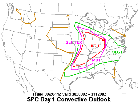
Model guidance suggests that the low-level jet will
   strengthen considerably during the evening, with forecast soundings
   showing very favorable hodographs for supercells capable of very
   large hail, damaging winds, and a few tornadoes.  Considered adding
   at 10% tornado threat area, but will defer to 20z update when
   eventual position of the boundary is better defined.

   Storms are expected to congeal into a bowing complex through the
   evening, affecting portions of north-central MO with the threat of
   rather widespread damaging winds and hail.
-
29 minutes ago, janetjanet998 said:
Usually, unless there is a strong system with a LLJ, the outflows sag south and the heavy rains fall south of the models...like the HRRR is showing
It is very rare you have the models dumping this much rain around here...I have seen see it in southern IL/KY into the mid south in winter/early spring flooding events near the OH river into TN...and of course tropical systems
July 1996 deluge fell during a drought if a recall correctly
NE IL is in drought but areas SW near me are not
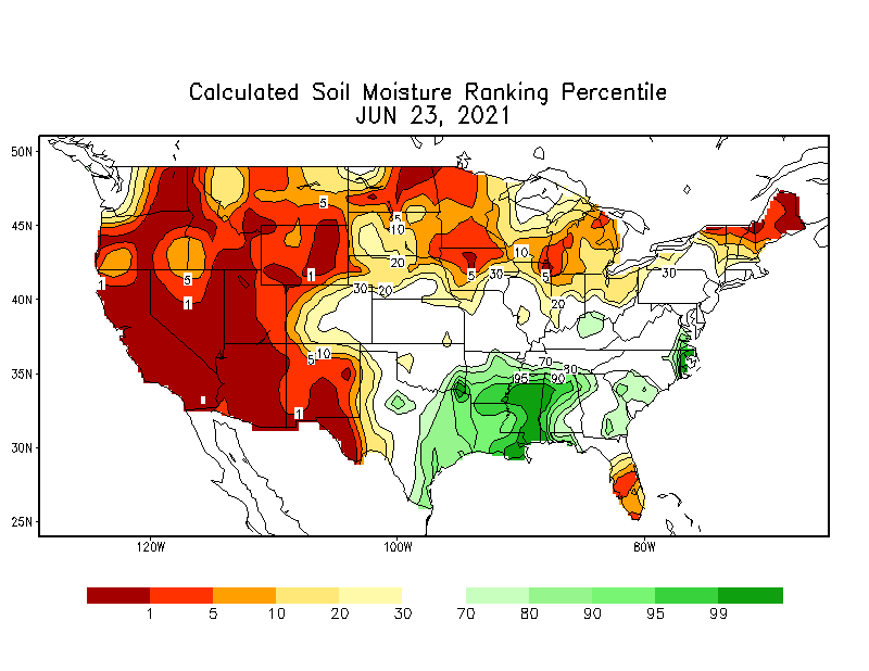
I agree. Heavy rain events in our region are almost always modeled too far north
-
From KIND
Long Term...(Thursday night through Tuesday)
Issued at 330 AM EDT Wed Jun 23 2021

Potential for serious to life threatening heavy rain and
flash flooding this weekend into next week as deep moisture advects
northward ahead of a warm front over the lower Mississippi Valley
and central Plains and a cold front over the northern Plains. The
warm front is expected to lift northeast across central Indiana
Friday as the cold front approaches from the northwest. Meanwhile, a
Canadian trough will dig southeast out of central Canada and result
in southwest flow aloft over the Ohio Valley. The cold front will
become aligned parallel to the upper flow as the front moves to just
northwest of central Indiana this weekend. This will likely result
in the front stalling out nearby with waves of low pressure moving
along it. The persistent synoptic forcing will tap into the deep
moisture, seen in precipitable water amounts greater than 2 inches,
and instability and result in widespread thunderstorms starting
Friday night. The alignment of the front with the upper flow will
bring the threat for training and the potential for several inches
of rain to fall over a widespread area this weekend into next week.

The highest PoPs will start off over the northern Wabash Valley and
gradually spread southeast over the weekend into next week.

WPC is advertising over half a foot of storm total QPF over the
Wabash Valley by next Tuesday with lesser but still impressive
amounts over southeastern sections.

With persistent warm advection, temperatures still look like they
could make it to the lower 80s each day despite the extensive
convection.
-
Chicago could get hit again this Friday imo
-
Kinda hate that states are not reporting as much. Think its too soon to do that even though this pandemic is basically over
-
Nightmare situation unfolding potentially
-
Just now, SchaumburgStormer said:
Its getting worse. Couplet is continuing to grow and intensify over burr ridge.
Prayers
-
2 minutes ago, BuffaloWeather said:

NOT GOOD!!!
-
Beast of a storm in Ohio
-
 About 5500 cape here in Indy. Wow
-
I can see towering cu to my northwest
-
 1
1
-
-
The parameters right now are very favorable for severe weather already
-
1
-
-
-
Definitely seeing less mask here in Indy
-
Mcs season is very unpredictable. Have to keep that in mind and remind myself not to get too excited. Lol
-
1
-


Spring 2021 Medium/Long Range Discussion
in Lakes/Ohio Valley
Posted
This appears the year of the never ending heatwave out west