-
Posts
2,065 -
Joined
-
Last visited
Content Type
Profiles
Blogs
Forums
American Weather
Media Demo
Store
Gallery
Posts posted by StormfanaticInd
-
-
23 minutes ago, Powerball said:
That, or we're all going to be storm chasing in AL and MS from now on...
It'll balance out. When is the question

-
 1
1
-
-
Nature has a way of balancing things out so I would be on the lookout for some extremely active years soon
-
 1
1
-
-
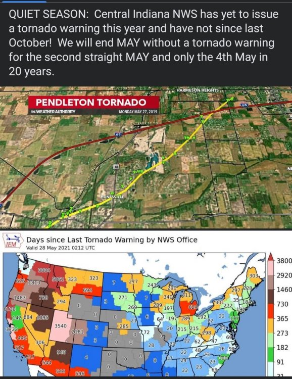
No real severe weather systems in sight and this is usually peak season for our region
-
 2
2
-
-
10 hours ago, Stebo said:
No severe or Tor warnings all year for DTX, its been almost 6 years since our last tor watch (June 21st 2015). If this is the new normal then I want out.
Wow. Six years!
-
 2
2
-
-
-
Covid19 is far worse than the flu. I know of several people that became severely ill or even died. Thankfully we have a vaccine now and this pandemic is almost over... Hopefully
-
I believe most of the deaths being reported now are backlogs from earlier in the year
-
 1
1
-
-
Reporting is low this holiday weekend but the numbers are very encouraging


-
-
1 hour ago, madwx said:
that's hastings but yeah that's pretty nuts
Just unreal

-
 1
1
-
-
-
Almost June. That's the beginning of meteorological summer folks
-
 1
1
-
-
This will no doubt be a cool summer
-
 1
1
-
 3
3
-
-
Smh. This storm season blows
-
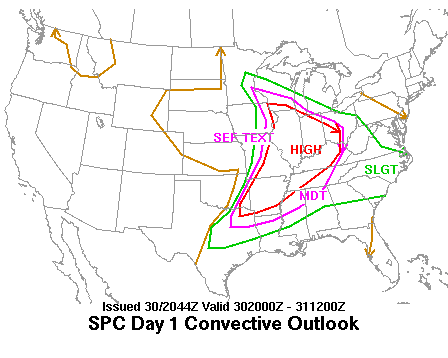
Marginal risk got expanded north some
-
-
the forecast
becomes murkier as multiple mitigating factors in play that suggest
the widespread convective potential is lower across the forecast
area than previously thought. There are growing signs of a split in
the favored areas for rainfall and convection...with the MCS riding
the instability gradient into the lower Ohio and western Tennessee
Valleys by tonight while the second area focuses to the northwest of
the region across northern Illinois into northern Indiana and lower
Michigan as a small low level jet transports moisture and enhances
lift around the top of the 850mb low. This will potentially place
much of the forecast area in between the better instability and
moisture to the southwest and stronger forcing aloft to the north
and northwest through tonight. There are even hints of weak mid
level subsidence and ridging over the area which further muddies
widespread convective concerns.
-
From KIND

There will be a severe threat with this convection late Thursday
evening into Thursday night. The moderate WAA will keep the
thermodynamic environment fairly conducive for longer. CAPE values
around 1000 J/kg are expected to maintain through around 04Z;
, diurnal cooling will begin to take over, limiting any
SBCAPE. Prior to this, the development of a nocturnal LLJ along with
a deepening surface low will create a fairly conducive environment
for isolated severe thunderstorms. Wind will be the primary threat
as by the time the thunderstorms reach central Indiana they should
be primarily linear. The strengthening LLJ and resulting speed shear
should help induce some RIJs within linear segments.

As diurnal cooling takes over, the thunderstorms will become
elevating reducing the wind threat greatly. This is likely to occur
shortly after the 04-06Z time period. The severe threat for the
entire region will greatly depend on when the thunderstorms reach
central Indiana.
-
1 hour ago, NEILwxbo said:
The first truck seen driving towards it actually ended up getting flipped over about a mile up the road
Wow
-
24 minutes ago, NEILwxbo said:
Out chasing in the Plains, caught the large tornado as it moved into Selden, KS yesterday. Got some pretty amazing video as it started to hit town, you can make out power flashes as it gets to the edge of town in my video here
was def by far the best chasing experience I’ve ever had
It never ceases to amaze me the idiots that drive right into the tornado. Smh
-
Pending what happens with the morning mcs
 Thursday has respectable potential for the lower ohio valley
-
Hospitalizations now at 23,925
-
Eyeing Thursday night

KIND


Models then show a low forming over the central plains that will
then move into the area Thursday. Rain could begin as soon as midday
in the far western portion of the forecast area, but better chances
look to be for the evening to overnight hours. This system seems to
be a better organized event with a threat for severe weather
included as the low passes through the area Thursday night into
Friday. The low level jet will likely set up aloft and ample CAPE
(in excess of 1000 J/kg) is also expected.
-
Cases are declining very fast. I think we are just about ready ( maybe even ready now?)to do away with mask


Spring/Summer 2021 Banter/Complaint Thread
in Lakes/Ohio Valley
Posted
That would suck. Lol