StormfanaticInd
-
Posts
2,065 -
Joined
-
Last visited
Content Type
Profiles
Blogs
Forums
American Weather
Media Demo
Store
Gallery
Posts posted by StormfanaticInd
-
-
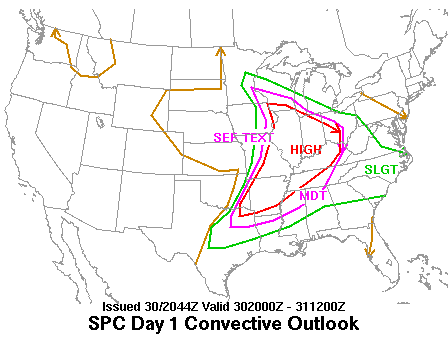
Moderate risk for flooding tomorrow night

-
Really this whole weekend looks active across the region

-
Tomorrow is looking pretty good for severe weather and flash flooding
-
5 minutes ago, hlcater said:
Tomorrow looks to provide a solid opportunity for a real nice MCS across Iowa.
Looking at potentially 5000+ MLCAPE, where spreads and mixing should favor cold pools and outflow dominance along with a 40kt LLJ. If it were me on desk, I'd have already introduced a 30% wind.
All the ingredients are there for a high end wind threat imo
-
-
12 minutes ago, Hoosier said:
Hopefully December isn't toilet worthy. Been getting too many of those lately.
One can only hope.
Looks like a cool potentially stormy couple of weeks coming up. Might be one or two hot days thrown in there to
-
54 minutes ago, Hoosier said:
A Spartman special for you all today


Winter is coming
-
Could be some severe weather this Thursday and Friday
-
Just now, StormfanaticInd said:
This pandemic is essentially over now imo. Cases and hospitalizations are now very low
We will however have to keep an eye out this fall and winter just in case there are any flare-ups
-
 1
1
-
-
This pandemic is essentially over now imo. Cases and hospitalizations are now very low
-
2 minutes ago, Chicago Storm said:
Downburst nearby...

.Fascinating
-
On 6/8/2021 at 10:11 AM, DAFF said:
Locally... I do not recall a single thunder storm this spring. Best was a evening with heat lightning over lake Erie. The rains which do develop are weak sauce with no real battle zone frontal passage.
I continue to be amazed at this pattern. Never in my lifetime have I seen it this quiet. Smh Strange times
-
 1
1
-
-
1 hour ago, IWXwx said:
Weird, I haven't seen nor heard the first one up here.
Northeast side of Indy is horrible. Lost track of how many flew into my windshield.
-
On another note these cicadas are everywhere


-
 1
1
-
-
1 minute ago, frostfern said:
It looks like a Florida-type pattern, which is always full of localized 1"+ bullseyes and holes. Will need at least three or four days in that kind of pattern to get a soaking rain everywhere. Would much prefer an MCS that shares the wealth more, but that's really hard to come by this year. Really tired of backdoor cold fronts and dry easterlies. That crap is getting really old.
Localized flash flooding could become a problem in this pattern but we need the rain
-
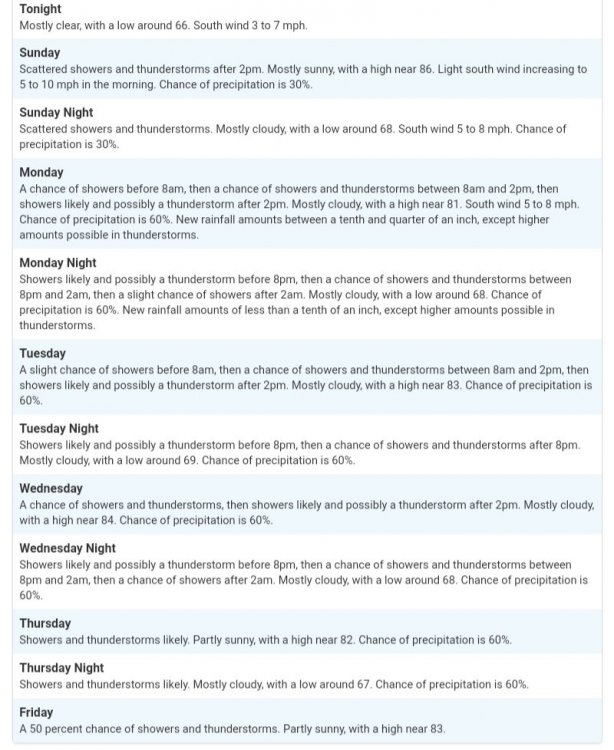
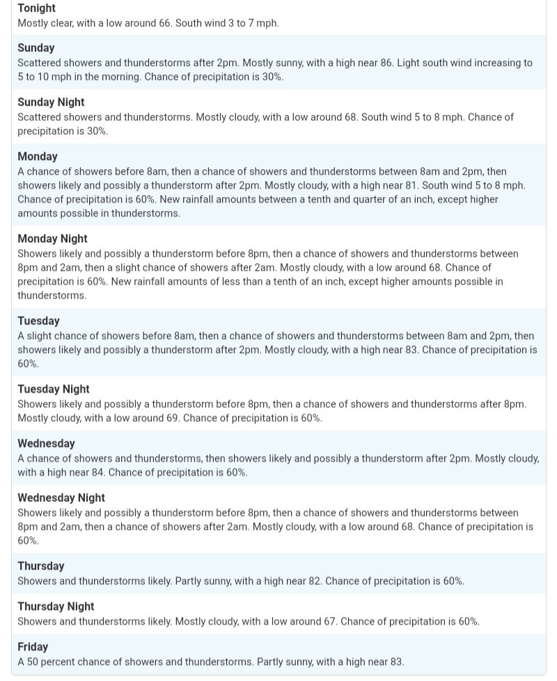
9 minutes ago, StormfanaticInd said:
Thunderstorms are likely almost every single day next week. Have not seen a forecast like this in quite some time
SundayA chance of showers, with thunderstorms also possible after 3pm. Increasing clouds, with a high near 85. Light south wind increasing to 5 to 9 mph in the morning. Chance of precipitation is 30%.Sunday NightA chance of showers and thunderstorms. Mostly cloudy, with a low around 69. South wind 7 to 10 mph. Chance of precipitation is 40%.MondayA chance of showers and thunderstorms, then showers and possibly a thunderstorm after 9am. High near 82. South wind 6 to 8 mph. Chance of precipitation is 80%. New rainfall amounts of less than a tenth of an inch, except higher amounts possible in thunderstorms.Monday NightShowers and possibly a thunderstorm before 9pm, then a chance of showers and thunderstorms between 9pm and 3am, then a chance of showers after 3am. Low around 69. South wind 5 to 7 mph. Chance of precipitation is 80%. New rainfall amounts of less than a tenth of an inch, except higher amounts possible in thunderstorms.TuesdayA chance of showers before 9am, then a chance of showers and thunderstorms between 9am and 3pm, then showers likely and possibly a thunderstorm after 3pm. Mostly cloudy, with a high near 84. Chance of precipitation is 70%. New rainfall amounts between a tenth and quarter of an inch, except higher amounts possible in thunderstorms.Tuesday NightShowers likely and possibly a thunderstorm before 9pm, then a chance of showers and thunderstorms after 9pm. Mostly cloudy, with a low around 69. Chance of precipitation is 70%.WednesdayA chance of showers and thunderstorms, then showers likely and possibly a thunderstorm after 3pm. Mostly cloudy, with a high near 83. Chance of precipitation is 70%.Wednesday NightShowers likely and possibly a thunderstorm before 9pm, then a chance of showers and thunderstorms between 9pm and 3am, then a chance of showers after 3am. Mostly cloudy, with a low around 69. Chance of precipitation is 70%.ThursdayA chance of showers before 9am, then a chance of showers and thunderstorms between 9am and 3pm, then showers likely and possibly a thunderstorm after 3pm. Mostly cloudy, with a high near 84. Chance of precipitation is 70%.Thursday NightShowers and thunderstorms likely. Mostly cloudy, with a low around 69. Chance of precipitation is 70%.FridayShowers and thunderstorms likely. Partly sunny, with a high near 85. Chance of precipitation is 60%.Friday NightShowers and thunderstorms likely. Partly cloudy, with a low around 67. Chance of precipitation is 60%.SaturdayA 40 percent chance of showers and thunderstorms. Mostly sunny, with a high near 84.
-
Thunderstorms are likely almost every single day next week. Have not seen a forecast like this in quite some time
-
Next week is looking active thunderstorm wise. It about time
-
-
1 hour ago, MJO812 said:
Thank you Trump
He has been shaky since day 1. Trump, DeSantis, Rand Paul and others called him out.
At times it feels like we are literally living in the twilight zone
-
1
-
-
Actually just had an actual thunderstorm

-
2
-
 1
1
-
-
Hospitalizations are now below 20k!!!!!

-
This summer will be cooler than average. I am almost 100% convinced
-
3
-
1
-
-
8 hours ago, A-L-E-K said:
looks like a snoozer, hopefully done with the furnace until october
If the trend of early cold continues it will be back on in September


2021 Short/Medium Range Severe Thread
in Lakes/Ohio Valley
Posted
Yeah it has been incredibly quiet. Looks like things are finally about to pick up