

Ed, snow and hurricane fan
-
Posts
1,647 -
Joined
-
Last visited
Content Type
Profiles
Blogs
Forums
American Weather
Media Demo
Store
Gallery
Posts posted by Ed, snow and hurricane fan
-
-
How many depressions form E of 50W after September 21?
-
A day old, but I was busy. Lower Gulf pressures would rob convergence from the Caribbean, but one good cold front might fix that. I'm a little impressed CV season is still going past the Equinox.
-
2 minutes ago, StantonParkHoya said:
It’s not tropical
Does that matter in the bigger picture? Edit to Add Image in Addition to Y Cantor tweet: Its subtropical

-
 2
2
-
-
Quote
2. Western Atlantic:
A non-tropical low pressure system is expected to form within a
large area of disorganized showers and thunderstorms to the east
of the Florida peninsula within the next day or two.  This system
could acquire some subtropical characteristics on Friday while it
moves generally northward.  Regardless of development, this low is
likely to bring gusty winds to gale force, heavy rain, and high surf
to portions of the Southeast and Mid-Atlantic United States late
this week and into this weekend.  Additional information on this
system can be found in High Seas Forecasts and products from your
local National Weather Service office.
* Formation chance through 48 hours...low...10 percent.
* Formation chance through 7 days...medium...40 percent.
40% orange.
-
Latest SHIPS has AHI of zero, not at all annular, but I see only outflow channels, not feeder bands. If it could close the eyewall on the E side it would at least look annular.
-
40 minutes ago, WxWatcher007 said:
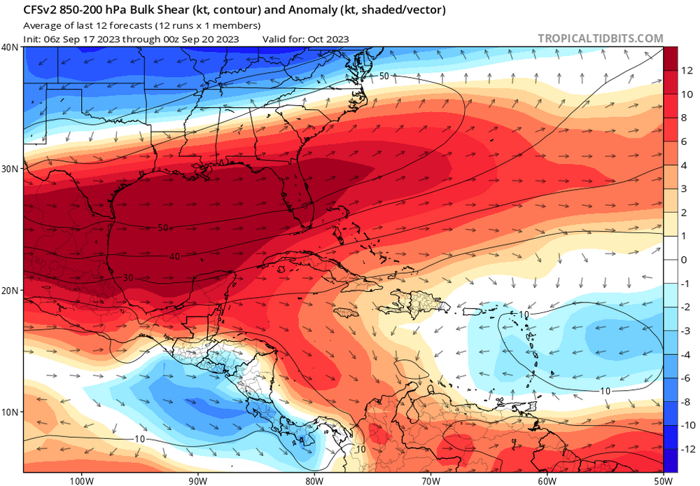
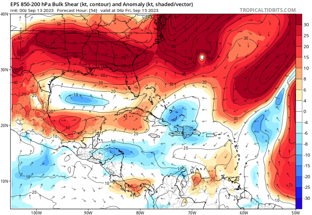
I disagree in part. Nino definitely lost during the last four weeks, but the MDR is more hostile than it was even a week ago, particularly with SAL. Not enough to keep that wave from developing, but it may stunt its development for a bit. I do think we’re transitioning to the western Caribbean and SE coast as we approach October but that’s not saying much because that’s climo. Will waves keep rolling off, yeah, but development is probably going to be more delayed or halted altogether, especially if shear picks up in the eastern Caribbean.
I'm not sure the usual 'second season' in the Caribbean in October happens this year.
-
 1
1
-
-
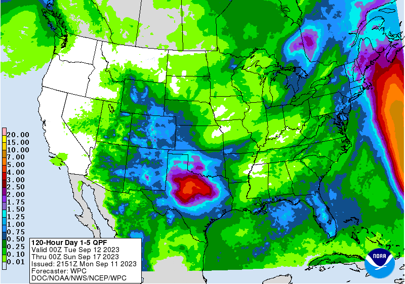
WPC QPF and 0Z GFS forecast show heaviest rain just offshore Carolinas to S New England. If this is impactful, I suspect it will be because of fresh water flooding.
-
1 hour ago, MattPetrulli said:
12z


Also interaction with high pressure to the north may lead to a tight gradient and creating a larger wind field than normal. I think there's enough here to put out a spot at 8 PM.
I like my isobars a little more circular. Longer term, Euro and ensembles and op GFS suggest a fish from NHC 7 day orange, but enough W members on GFS ensembles to suggest a NE Caribbean/Bermuda threat. Edit to Add: weaker Euro members aren't recurving although the mean at 240 hours looks like OTS
-
Getting the light stratiform rain between cells, better than no rain at all.
-
4 hours ago, olafminesaw said:
A little home brew weenie bait

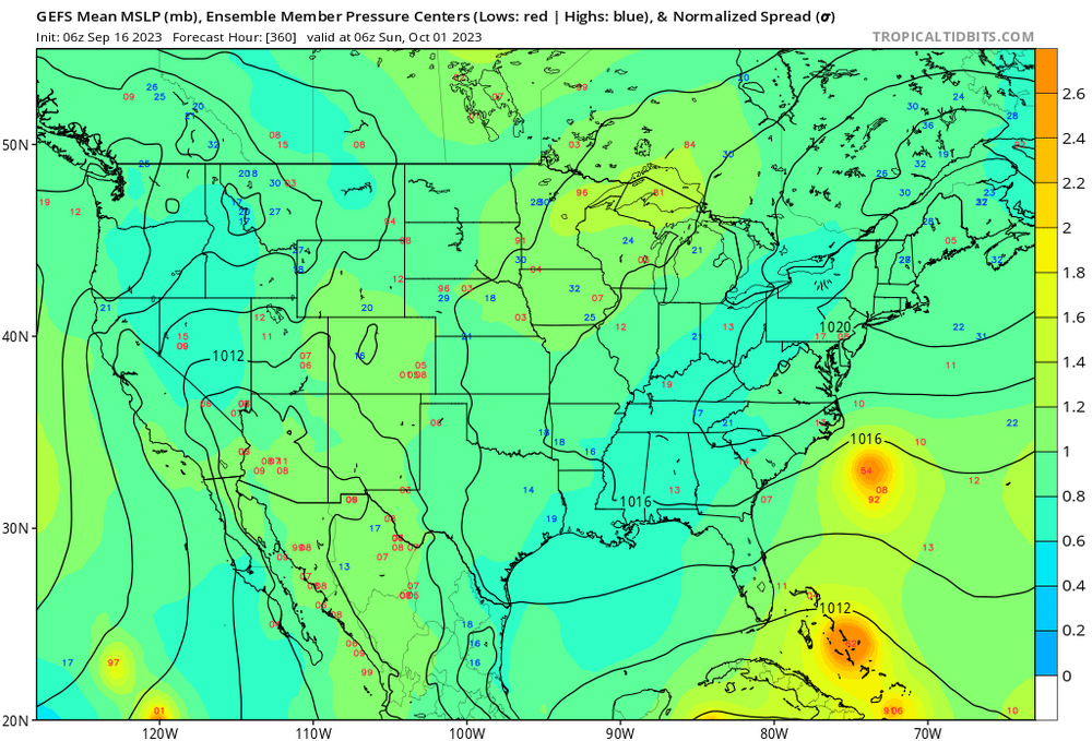
30 knot storms on the ensemble aren't as interesting as the persistent (0, 6, 12Z) GFS ensembles suggesting a system that might not develop as quickly as its predecessors and pose a Cape Verde season in overtime threat to the E Caribbean (and SEUSA?) Weenies can ween for days, GFS family have seemed decent in not being too overenthusiastic, except in the SW Caribbean where it has done that since probably AVN/MRF days
-
Been skunked two days in a row. Yesterday I saw the lightning and the dark rain curtain, but nothing. The line then filled in completely once past. Trying to will storms to the WNW to move E and not SE. 1.7" PW IMBY as compared to the 2" PW to the W suggests another dry day is possible.
-
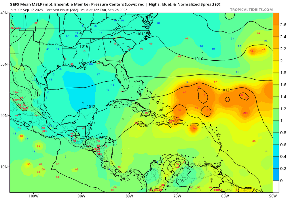
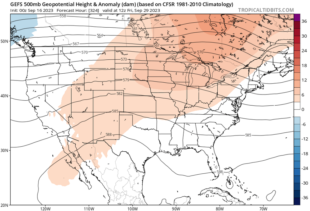
End of month GFS ensembles look interesting Caribbean/maybe ECUSA. Enough of a signal to show up on the means.
-
4
-
-
I feel a bit cheated. One day of RI with incredible recon (and Jova in the Pacific), then the mid-level shear and weakening.
But ACE was 105 yesterday, already a near normal season in an El Nino. I thought the CSU numbers were whack, but apparently not.
-
1
-
-
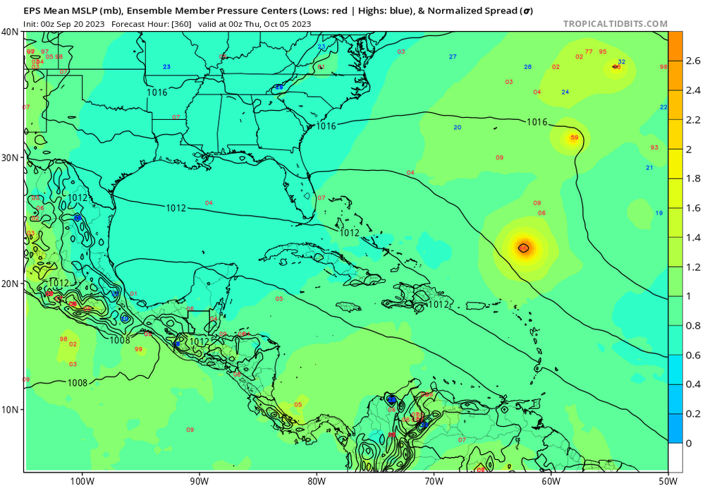
The Gulf and Caribbean are staying quiet at least through the next two weeks per the GFS ensembles. Little to no activity through mid October for the Euro weeklies. Good for Florida. I don't see why the Caribbean would be so quiet, although weeklies suggesting EPAC action which would be suppressive of the Caribbean.
-
2
-
-
Only 96* in Houston and afternoon dew points dropped to 59*. And it should rain.
-
4 minutes ago, Wannabehippie said:
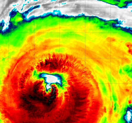
The Southern part of that warm area is where I would expect to see the eye with cold tops wrapping around it. The rest of it looks 'wrong' to me somehow. Like something is hindering the storm.
-
1 hour ago, Wannabehippie said:
Does anyone have the flight data to see if the eye of Lee is open or closed?
Image courtesy of Tropical Tidbits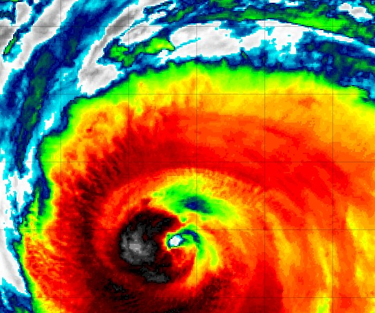
Open on last VDM, although that was 5 hours ago.
-
1
-
-
38 minutes ago, GaWx said:
How accurate are those two tropical models for track vs the main global models?
Good question. I do assume using the GFS to set the conditions near the edges of the nest is related to ending the high res hurricane models early. Not the same model obviously, seeing the HAFS models have ocean-atmosphere coupling the NAM's clearly don't need, but they have to becoming very dependent on the GFS boundary conditions calculated at a lower res. With the HAFs being W of the others when they end, I would want to know how they perform at the end of their runs.
-
1
-
-
16 hours ago, MJO812 said:
Triggered wannabe meteorologists

Mute/Block and move on for anyone who insults your family. I also ignore 94 follower teens who use plural pronouns, as if part of a group. I try to ignore anyone with few followers who are full weenie.
-
1
-
 1
1
-
-
Looking at the ensembles and available models after church, I would still bet money that it is far enough E of New England for no more breezes on land (like what I felt in Lafayette, LA during Georges 1998 or 2000, mostly clear skies, but noticeable breezy) but I wouldn't bet big sums. Maybe 30% chance of sensible weather beyond just fresh breezes in New England, and 15% of a landfall. If I weenie after growing up in Massapequa, I go about 5% on Long Island landfall.
Hot towers and a warm spot eye on IR, not yet detectable (but should be soon) on visible and the VDM, I think a slow intensification is happening. Maybe gets to Cat 4. Coupled air/ocean HAFS=A models support call for weakening due to Franklin or its own cool wake after getting back to Cat 4. That model (Andy Hazelton must have worked on it, he is proud of it) has been decent so far..
t
-
Gulf/Caribbean on the ensembles look like February, as far as tropical cyclones go.
-
I thought I read somewhere this has happened. I might be wrong, but I wouldn't think the op would be an outlier to its ensembles.
QuoteSince ensemble forecasts began at ECMWF, they have been run at a lower resolution than the single 10-day forecast. This will change in 2023, when the resolution of the medium-range ensemble forecasts will double from a grid spacing of 18 to 9 km – our 15-day ensemble and single 10-day forecast will be run at the same resolution. This is a really significant step forward, made possible with the power of our new Atos supercomputing facility in Bologna, Italy. The extended-range forecast is also increasing from 51 to 101 ensemble members, running at a horizontal resolution of 36 km from day 1 to day 46.
-
1
-
-
16 minutes ago, MJO812 said:
Let the hype begin
Checking JB's Twitter feed now.
Edit to Add. A Twitter met who either once posted here or Storm 2K, a Derek Ortt, who has an MS in met with a thesis about the effects of shear on systems with dry air around them, who knows more than I do, says resolutions below 10 km makes for bad tropical forecast solutions. The 3 km hurricane models follow the storms. Ortt works for a 'WxMan57', they sell products mainly to the energy industry, a big part of their business is tropical forecasting.
-
 1
1
-
-
1 hour ago, Derecho! said:
? There are Six (CT, MA, 4 in Maine).
I didn't think any more were happening after hour 180...
-
1
-


Texas/Oklahoma 2023 Obs and Discussion
in Central/Western States
Posted
Area of storms that on current trend will miss Houston metro to the E. CAPE is sufficient, a bit of backbuilding W wouldn't be surprising. And then whatever comes down this evening/tonight from the North and Central Texas SPC outlooked storms.
7 day GFS ensemble rain total for my house (and on down into STX) is just under half an inch. Hit and miss nature of recent rain suggests fire danger still exists.