

Ed, snow and hurricane fan
-
Posts
2,133 -
Joined
-
Last visited
Content Type
Profiles
Blogs
Forums
American Weather
Media Demo
Store
Gallery
Posts posted by Ed, snow and hurricane fan
-
-
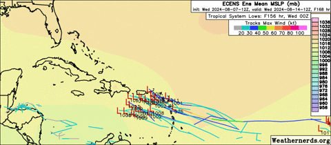
Euro and most of the ECENS are developing the wave now near 40*. Not looking as 'fishy', many ensemble members get it into the Caribbean before a recurve. Most members that cross the G. Antilles aren't strong, but the rain and topography would cause issues. EDIT TO ADD: Hours 156 to 210. A week away, but a strong signal. Op GFS slower development gets it into the Gulf. Not as much ensemble support, but Im starting to suspect the combination to the constant refinement of the model and lower resolution may contribute to GEFS not supporting the op when they would if run at higher resolution.
-
 1
1
-
-
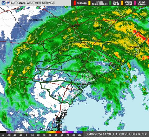
Convection is blowing up over land. If that somehow stays there more than a few hours, that will be a problem. WPC analyzed cold front may be too far inland, but I'd guess prefrontal trough. I can't really see it in the SPC RAP analysis.
-
13 minutes ago, GaWx said:
The 12Z Euro has an AEW that crosses Hispaniola and then leads to a TC forming in the SE Bahamas by 216 and that turns NNE aiming for W of Bermuda at 240 as it recurves due to a trough.I have a question, regarding the GFS seeing TC genesis before most of its ensemble members do, as compared to the ECENS- is resolution an issue for the GEFS? Do you know if anyone has access to the control run? When the op and the ensemble are run at different resolutions, does that cause these issues. Can you see the GFS ensemble control member?
-
8 days out, the GFS has a very Debby-esque tropical wave entangled with the Greater Antilles from the wave EPS have been liking. Intensity and when it might recurve would be very much deterimed by whether it misses the islands to the N anf fishes or stays S of the G. Antilles and is more than a TD by the time it reaches the Gulf.
-
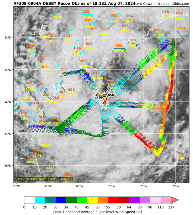
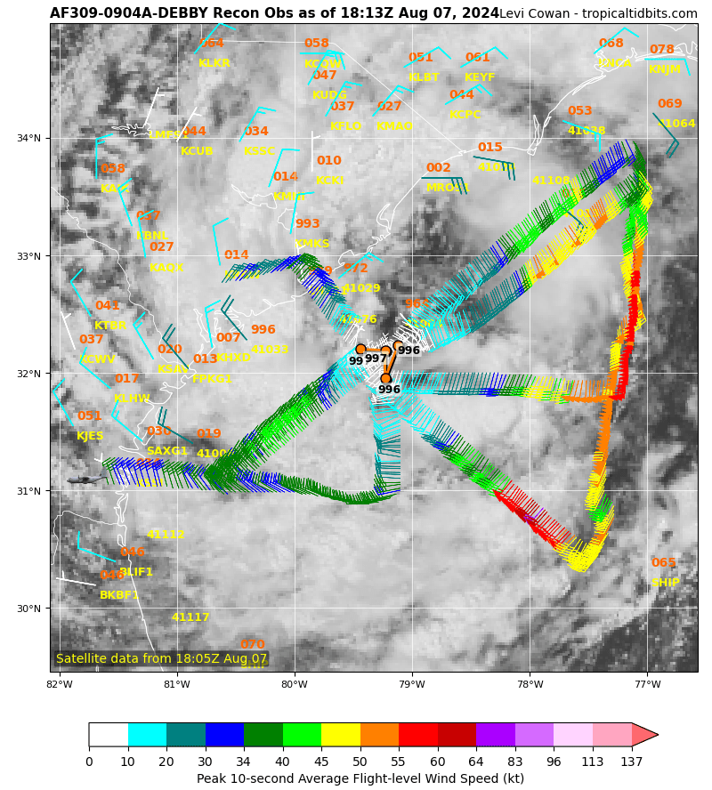
Recon has impressive winds for such a trainwreck of a system. Facepalm for people apparently disappointed that Debby won't make a run at Cat 3 and drop 10 feet of rain in 2 days.
-
4
-
 1
1
-
-
1 hour ago, marsman said:
Lumber river forecast off the chart:
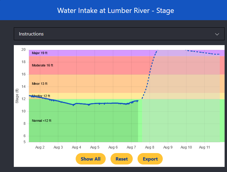
Lumberton is prone to severe flooding, I hope that projection is wrong.
-
5 minutes ago, CurlyHeadBarrett said:
What strength are they talking right now and could this become a conus threat?
Way to early to know. You know I'm a math teacher, not a meteorologist.
-
3
-
-
2 hours ago, CurlyHeadBarrett said:
First non GOM storm of the year?

Who knows? That solution is well supported by the EPS, weakly supported by the GEFS.
-
1
-
-
I generally trust the ECENS most for spotting future TS without to many false alarms. The 10/30 lemon was a bust, but the ECENS were days ahead of the other models spotting Beryl.
Euro ensembles look to have a few more perturbations at 6Z than 0Z.
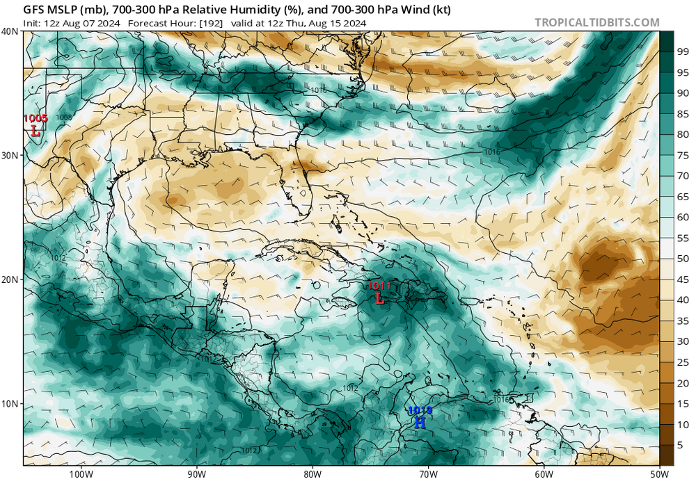
*Almost* mp ,ode; support for the E Caribbean lemon, although one GEFS member does bring a storm from the far S Caribbean at a time consistent with the lemon and brings a strong TS/low end TS to Houston. The GEFS and the GFS false alarm all the time systems that develop in the SW Caribbean from almost undistinguishable vorts travelling W through N South America. It also false alarms TCs when the monsoon trough extends into the Caribbean. But I'd bet money on a TC around mid-month. If it isn't OTS, it could be impactful. Betting on no or only 1 storm(s) in the second half of August with a near record warm MDR iand a near neutral ENSO seems like a losing bet.
-
1
-
-
Morning WPC 5 day QPF doesn't suggest much orographic enhancement, but the E halves of the Carolinas are >10 inches with some >15 inch areas.
I assume that is a computer created consensus of models, with forecasters adjusting which models have more and less, or no weight. Consensus seems the way to go.

-
ECENS or EPS means the 50 member ECMWF ensemble. Each one with a minor computer generated adjustment to the initial conditions the Op Euro is run from. A wide variety of outcomes suggests that the initial conditions (which are never perfect, measurement area and data the initialization program produces has interpolated conditions between data points. The ECENS liked, than lost 9as did the US GFS operational and the Canadian Global operational model did. Something changed to make the majority of the ECENS forecast a more S'ly track with more hostile conditions.
The wave in the EATL may do as the E. Caribbean lemon do, show more and more support then lose it as newer data comes in every 6 hours, or show more and more ensemble members show development and other modelling also sees a system ala Beryl.
New op GFS shows no development in the E Caribbean, few models or their ensembles show anything, it has become extremely unlikely anything forms. GFS has the surrounding dry air keeping the E Atlantic wave from developing in the Caribbean. If the GFS is correct that dry air will hinder development but not prevent it, it has a better chance to not recurve before land impacts.
-
 1
1
-
-
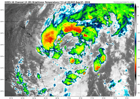
The center is disrupted enough it won't become a hurricane again over water, but if it gets far enough out, I could see near hurricane pressure but without the hurricane force winds because it won't have enough time.
-
Debby is indeed hollowed out, but the center is still there and close enough to the coast it shouldn't weaken much over land.
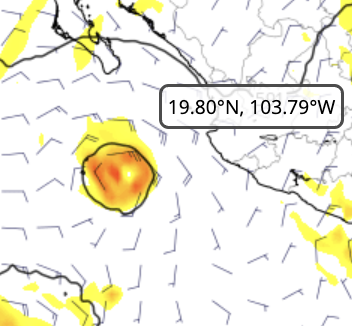
[img]
 [/img]
-
CHB- the ensembles seem to think so. Slower development than what the ECENS are suggesting increases the chance it doesn't go OTS.
-
1
-
-
I think the only problem with the Euro ensembles a few days ago on the current 10/30 lemon in the Caribbean is it had most of the members a smidge too far N. Now seems too close to S. America to develop, the few members that do develop run into Central America.
A fair number of ECENS like the wave just coming off Africa. Looks good on MIMIC-TPW, but not convectively active, with dry air ahead it will take a few days. Most would be OTS on day 10 ECENS, but lets see if it forms first GEFS has more than a few members seeing it also, and the MJO should be more favorable for the EATL wave than it was for the very unlikely to develop current lemon.
-
1
-
-
14 hours ago, CurlyHeadBarrett said:
Euro has the wave as Gilma (not Ernesto) and very short-lived and weak
That goes in the EPAC thread.
-
1
-
-
21 minutes ago, StantonParkHoya said:
Watch Levi’s video from today where he details the difference
Ok, I can delete my coast. Missed this post.
-
I'm not calling bust on the wave entering the Caribbean, just saying NHC 10/30 probs are about right. More ensembles, not less, should see a system as time progresses to really have confidence on TC genesis. Op Euro doesn't develop it either.
-
No, he is a weenie.
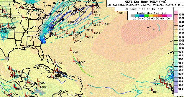
I count 5 GEFS perturbations that could affect Texas or Louisiana from the Caribbean wave, and 1 Debby reenters the Gulf member. Dismissing that as an oulier. Not terrible odds, but under 20% isn't good odds, either. EDIT TO ADD: I count 4 Canadian Global model ensemble members that put TCs into the Gulf. 4 of 20. 20%
-
 1
1
-
-
Yes. I think maybe he hopes always calling the Atlantic a graveyard will trigger the hurricane gods to send another Isabel his way.
-
2
-
-
3 minutes ago, CurlyHeadBarrett said:
Do you really think this season would be like 2022/2013 jfl
I interact with ldub, though I have been warned he may be a troll. He disappears from the board when there are systems in the Atlantic. At least he no longer posts GFS Hour 384 (day 16) surface maps showing either the surface ridge means no way a storm doesn't curve out to sea. Haven't seen 384 hour maps from him in years.
-
2
-
-
23 minutes ago, ldub23 said:
I saw but it seems unlikely. 25 named storms? Lets say Aug has 2. We need 10 in sept and 10 in OCT. Aug has to be busy to get to 25 and nothing now says busy. Eric Webb says the MJO is Favorable now and wont be in Sept. The season so far is 2 tropical storms hitting the US with the only reason they got to a cat1 was interaction with land. We all saw how all the forecasters were saying how super favorable the tropics were this season. Im not seeing it. Once again the Mdr is choked with dust, dry as a desert, with sinking air added in. Beryl was a butterfly effect thing where somehow it managed to do the impossible but that isnt going to keep on happening.
We arent even getting a sniff of anything developing in the subtropics this season. I have no idea what has to happen to get moisture into the Atlantic again but el nino, la nina, anything inbetween and we end up with a dead MDR.

A lot of posters don't think there'll be 2005/1935 number of storms. It is the rare storm that develops in the subtropics or even in the tropics that affects the US. 18 storms and an ACE of 200 would be quite active in my book. Two landfalling US hurricanes by August 5 feels active to me.
-
1
-
-
2 hours ago, ldub23 said:
Debby struggled all the way across just to have convection. Still looks very dry and loaded with sinking air.

I think the 12Z GFS is wrong, but check out about hour 180 or 204.
-
Ensemble models yesterday looked like a hurricane risk for the W Gulf was possible, almost probable.
0Z and 6Z models and ensembles are backing off that in a major way. There is another wave just off Africa, but I suspect a fish.


2024 Atlantic Hurricane Season
in Tropical Headquarters
Posted
I don't how to do an analog off a model run of a storm that hadn't developed yet. I told you I'm not a met, just a hobbyist. There are some analog guys for an actual storm in an actual position, but I'm not an expert on that, either.