

Ed, snow and hurricane fan
-
Posts
1,618 -
Joined
-
Last visited
Content Type
Profiles
Blogs
Forums
American Weather
Media Demo
Store
Gallery
Posts posted by Ed, snow and hurricane fan
-
-
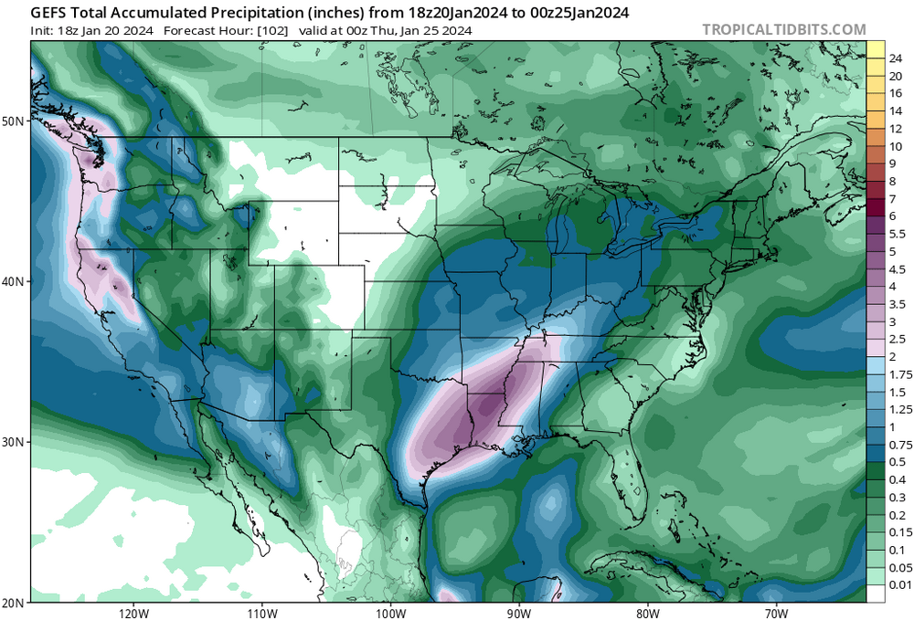
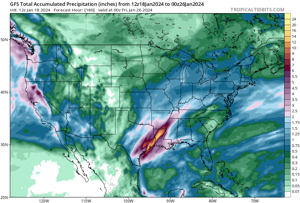
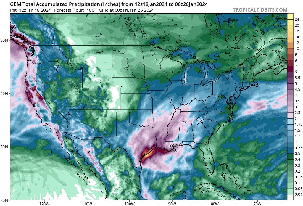
Models have backed off a smidge on next week's rain in S/SE Texas, but widespread >3 inch rains still look possibly. FWD not going with a WWA, models came in a smidge less precip and slightly warmer temps per AFD.
-
 1
1
-
-
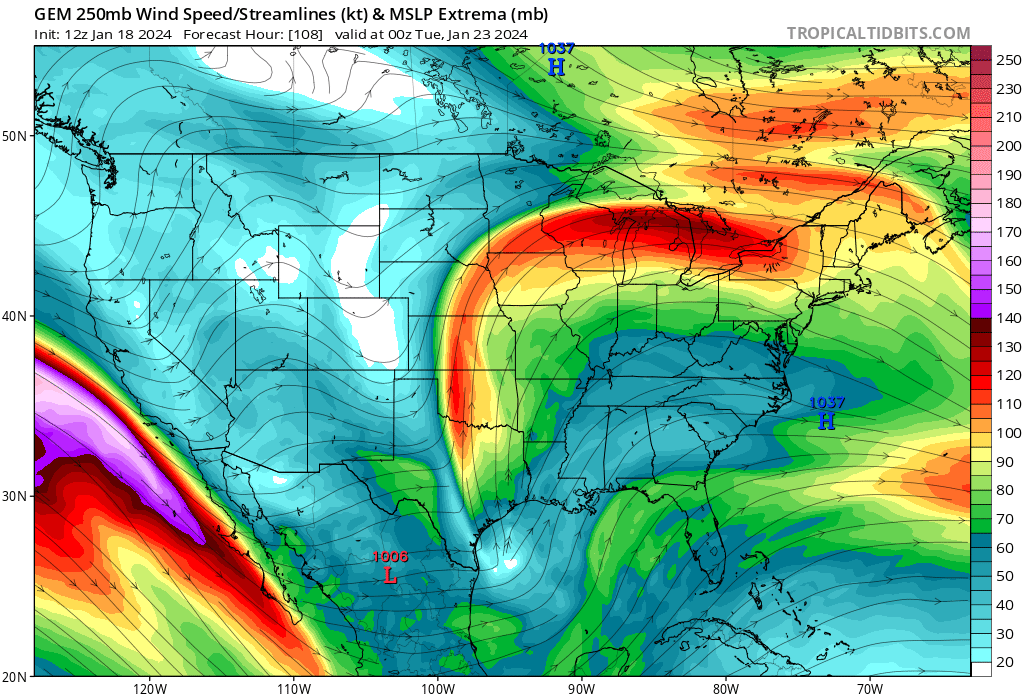
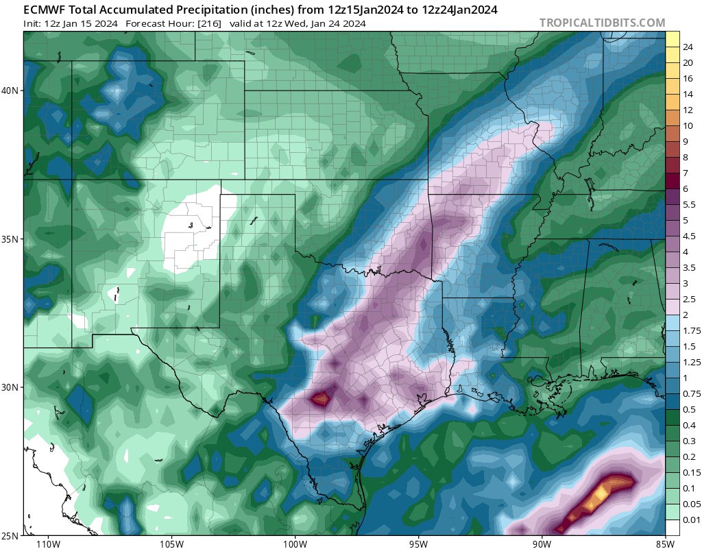
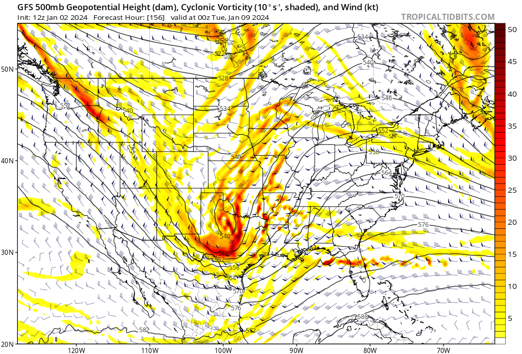
Still time for things to change for Monday, but GFS still shows the warm sector confined to the immediate coast and a near saturated sounding from the surface to 200 mb. Greater than 50 knot LLJ and PW's near 1.6 inches and a divergent jet means heavy rain, which all the important globals have been seeing for several days. GFS/CMC/Euro differ in exact amounts and locations, but all show widespread 2 inch plus amounts. Differences become more pronounced with succeeding rain events, but the neg tilt trough is in no hurry to move out. By Thursday evening the rain events have dropped a large area of 5 inches with some 10 inch amounts showing up. Not ruling out severe, the warm sector coming a bit farther inland opens up SETX and the Coastal Bend, and there are hints of that for Wednesday.


-
2 hours ago, Stx_Thunder said:
Sucks having to run 2 heaters just to keep warm enough inside with this reinforced airmass as the CAA north wind picked up again outside last night. Though am glad it actually cleared out now around the coast as it should definitely push above freezing to around 40 F today (maybe even 60 by tomorrow as the arctic high starts to move away).
---
Since it'll likely be much warmer next week (compared to this week), multi-global model output already showing some maxed out thunder probabilities here on the coast with more steep mid-level LRs at times in the state and pretty strong DL shear once again (up to 70 - 80 kts) also on both Euro & GFS, Monday - Wednesday (ahead of next week's incoming trough out west).
SPC also already hinting at severe potential for southern plains next week in D4-8 outlook discussion today.

Severe is possible, but the 2 systems early week have 5 inch rain bullseyes on both the GFS and CMC. GFS suggests CAPE is low with a nearly saturated profile. 1.6 inch PW. Of course, 6 days out, the warm sector not quite getting beyond the coast can change. On another note, 19F this morning for a min at IAH breaks the daily record of 22F from 1972.
-
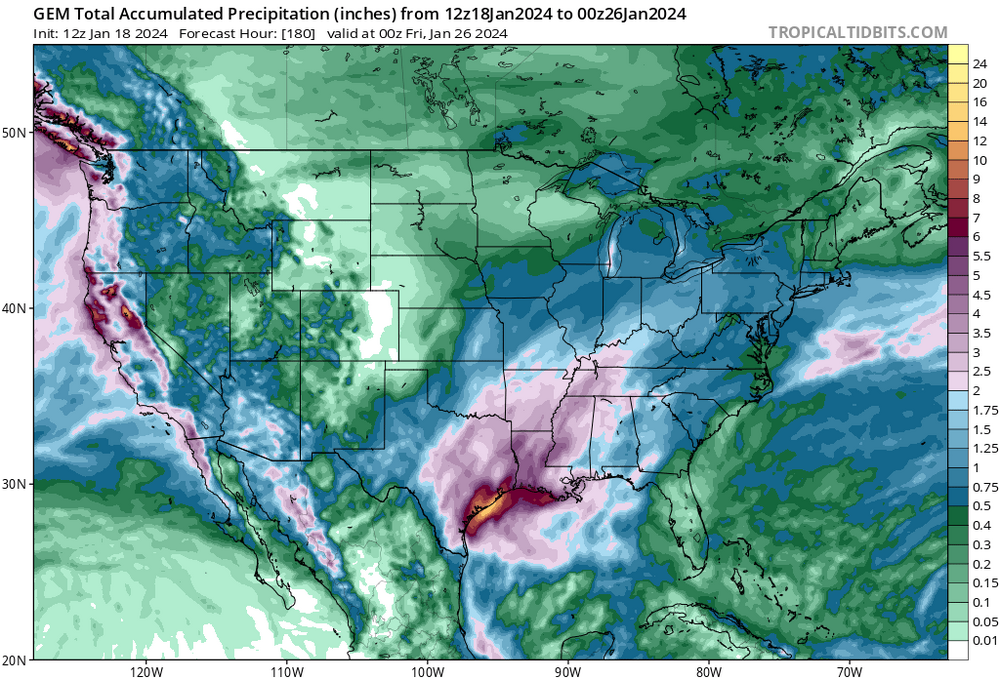
I somehow doubt the Canadian (it shows a big DFW ice storm), but all the globals like heavy precip next Monday-Tuesday.
-
1
-
-
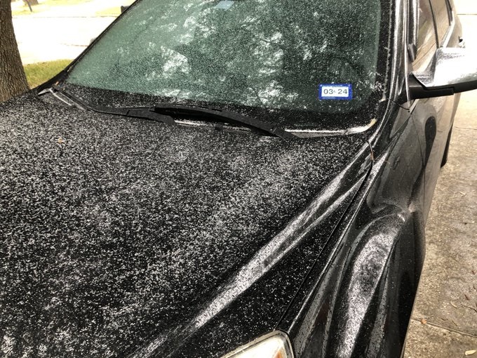
Very light drizzle, water on the sidewalks is water, but building up on plants and cars in Houston. Klein and Tomball ISD, among others, have cancelled school.
-
The switch from rain to sleet was pretty fast.
-
1
-
-
Liquid rain halfway between IAH and DWH. 34F at airport, temp and DP are falling. If we get ice beyond a trace of freezing drizzle, I will have been wrong based on trusting models.
Edit: IAH is now 28F
-
Driving down from DFW, about 1 pm near Alma the grassy surfaces alongside I-45 were white with sleet. No precip, down toward Corsicana, light sleet or snow flurries, not sticking to anything. Big rise in temp, about 15 degrees in maybe 30 miles around Huntsville. 18F on Toyota thermometer in DFW, 47F Spring area. No idea why Houston metro is in a WWA. A trace of precip over many hours w/ marginal temps, I guess an abundance of caution. I can see that well NW of metro Houston. Interestingly, freezing precip gets very near the coast well S of Houston, but not the Houston metro.
-
Canadian Reggie has a decent sleet/ice event from the Hill Country to the far W and NW suburbs of Houston. Not sure how trustworthy a mesoscale is this far from the center of the domain and this far out in time. 18Z NAM not as impressive, but similar areas. Total precip on the 12 NAM about 0.2 inches liquid equivalent of sleet and ice. Reggie has a stripe of >0.5 liquid equivalent of snow, ice and sleet from just E of DFW towards Texarkana.
-
1
-
-
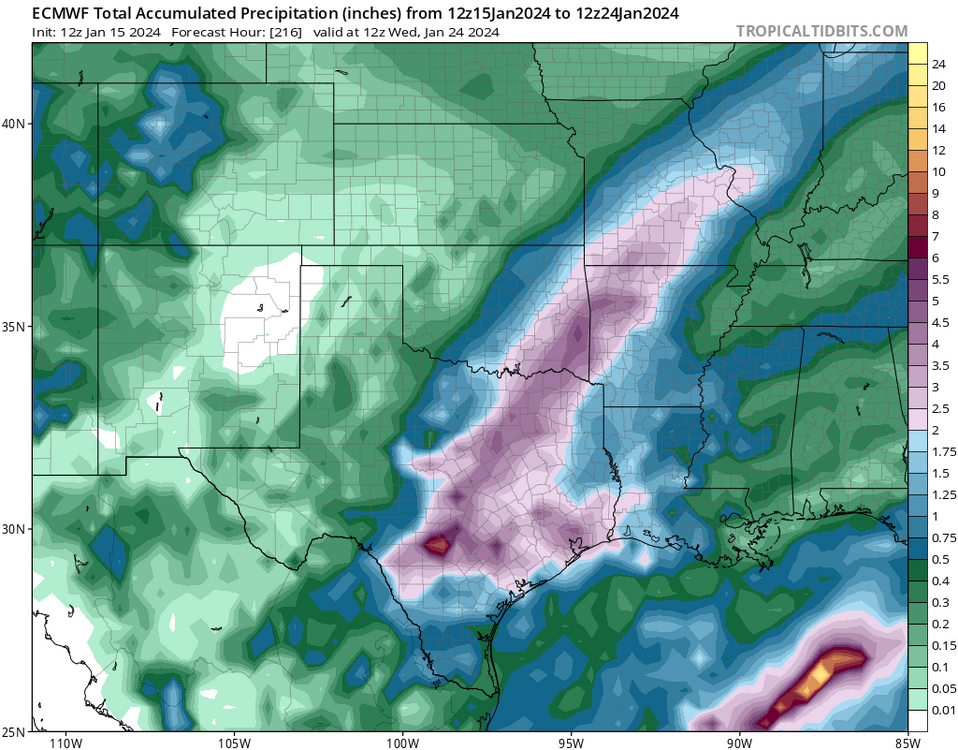
That storm comes through Houston first and local NWS is discounting the Euro in favor of the Canadian and GFS. Euro is only one w/ chance for a Houston ice disaster MLK day into Tuesday, although verbatim smidge too warm. Freakish cold, in the teens. Freakish except 2/2021 and 12/2022 also had sub 20F nights, 2021 was the power grid failure. No longer doubt CC, two months over 100F and pushing 110F many days, followed by once every 20 year cold spells happening almost every year means something has changed.
What does NBM guidance show?
-
HGX is pretty much dismissing Euro solution of freezing rain in Houston on MLK Day, but both KTRK (ABC 13) and KHOU (I expected better from David Paul) seem all in on the Euro. I trust NWS and the GFS.
-
Although El Nino winters are usually cooler on average, all the nasty, freakish (low 20s or below) cold snaps that have hit Houston happened during cold ENSOs, and NWS forecasting teens.
-
1
-
-
-
1 hour ago, canderson said:
I think Dallas is in a decent spot to get a couple inches of snow actually next Monday. It’ll be icey but might be snow for a while before the inevitable changeover. Weatherford NW seems ideal for a legit snow.
Euro 850 temps reach freezing around 12Z Monday, with three to four tenths falling. I'm going to be optimistic and say 4 inches of snow isn't out the question. That is good news, bad news is Houston drops to between 20 and 24F Tuesday morning with near 15 hours of sub-freezing weather. This results in my palm tree looking like it is dead for 4 or 5 months after. Would have been nice to not have a hard freeze two of the last three winters.
-
Sleet and snow MLK day in Dallas per 0Z and 6Z GFS.
-
2
-
-
Meanwhile, IRI models suggest a neutral ENSO around the Equinox. It'll be interesting to see if the Atlantic again has record and near record warmth. The Nino style quick hitting rains every 3 or 4 days continues in Texas with cooler than normal but not cold temps. The frequency is just enough to limit deep return of Gulf moisture, although tomorrow night into Tuesday morning, I-10 corridor from Baton Rouge to Panama City is in an enhanced risk with hatched tornadoes, where enough of a warm sector looks to come ashore. That extends to ECUSA Tuesday.
-
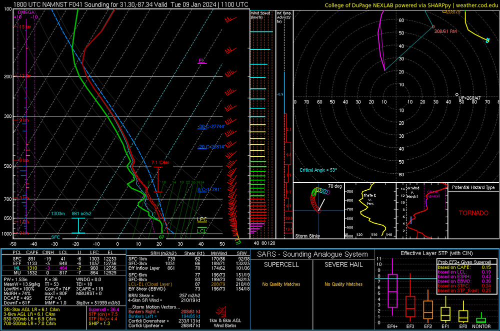
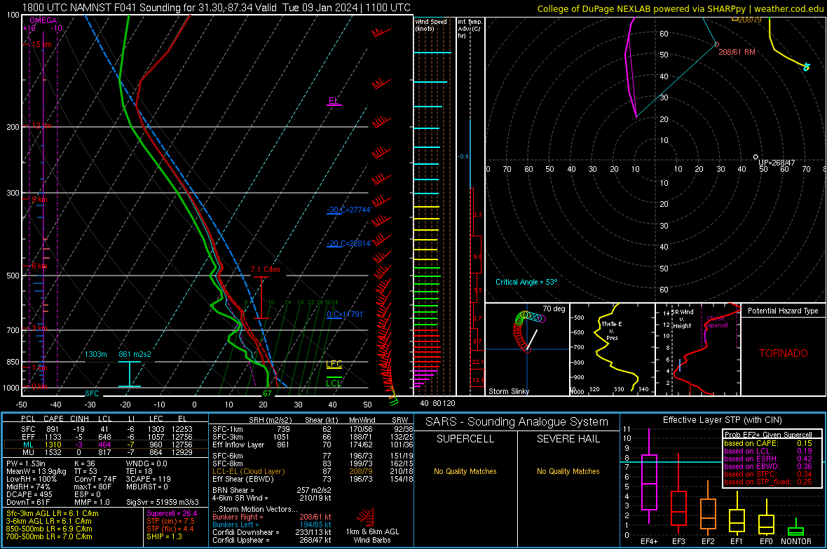
Hatched tornado Monday I-10 corridor from BTR to KECP. The worst looks to be Mississippi and Alabama after midnight. South Alabama sounding below
-
54 minutes ago, WxWatcher007 said:
Run on the stores. Long lines with bread being restocked

Been 40 years since I've been in New England, I recall Nissin was the popular winter storm bread.
-
3
-
-
40 knot sustained 10 m winds on Long Island mid-week on 18Z GFS, that probably adds some salt water to the fresh water flooding
-
On 1/3/2024 at 11:56 AM, Powerball said:
lol at the 12z GGEM.
Ain't gonna happen...
Not as much snow, but still snow on the backside of the Monday storm in NCTX Tuesday morning on today's CMC (2-4 inches). Still in a 15% risk I-10 corridor from near San Antonio to Alabama with that storm Monday. Euro and GFS show limited surface instability (near/less 500 J/KG ML) but close to 1500 MUCAPE with about 50 knot LLJ Monday mid-day.
-
43 minutes ago, STILL N OF PIKE said:
I asked Scott this am and he said it was off B.C coast and then the path it takes is pretty ..”fun” so I mean and we are hoping for models to realize how not only this tracks ..but it’s precise interaction with a lead short wave that is subject to small changes itself . It’s really kind of amazing what models can do if you stop and appreciate them .
Can be plenty of changes into tomorrow pm thanks to that delicate interaction, I think the goal posts are wider than folks think , thou models have stabilized a bit Today but it wouldn’t shock me for a new trend to emerge in 12 hours in any direction
Might get lucky with recon for the ATL, Gulf and Pac.
QuoteWEATHER RECONNAISSANCE FLIGHTS CARCAH, NATIONAL HURRICANE CENTER, MIAMI, FL. 0155 PM EST WED 03 JANUARY 2024 SUBJECT: WINTER SEASON PLAN OF THE DAY (WSPOD) VALID 04/1100Z TO 05/1100Z JANUARY 2024 WSPOD NUMBER.....23-034 CORRECTION I. ATLANTIC REQUIREMENTS 1. FLIGHT ONE - TEAL 71 A. 05/1200Z B. AFXXX 04WSA TRACK66MOD C. 05/0800Z D. 20 DROPS APPROXIMATELY 60 NM APART WITHIN AN AREA BOUNDED BY: 29.3N 91.1W, 29.3N 93.9W, 28.9N 95.1W, 28.0N 97.0W, 28.0N 97.5W, 23.5N 97.5W, 23.5N 87.0W, AND 29.3N 87.0W E. AS HIGH AS POSSIBLE / 05/0830Z TO 05/1430Z F. MODIFICATION TO PUBLISHED TRACK A66 2. OUTLOOK FOR SUCCEEDING DAY: ANOTHER POSSIBLE MISSION OVER THE GULF OF MEXICO FOR 06/0000Z SYNOPTIC TIME. II. PACIFIC REQUIREMENTS 1. FLIGHT ONE - TEAL 74 A. 05/0000Z B. AFXXX 04WSE IOP12 C. 04/1745Z (CORRECTED) D. 25 DROPS APPROXIMATELY 60 NM APART WITHIN AN AREA BOUNDED BY: 35.0N 155.0W, 35.0N 125.0W, 55.0N 125.0W, AND 55.0N 155.0W E. AS HIGH AS POSSIBLE/ 04/2030Z TO 05/0230Z 2. SUCCEEDING DAY OUTLOOK: A USAF RESERVE WC-130J AIRCRAFT MAY FLY AN ATMOSPHERIC RIVERS MISSION OVER THE EASTERN PACIFIC FOR THE 06/0000Z SYNOPTIC TIME. 3. ADDITIONAL DAY OUTLOOK: A USAF RESERVE WC-130J AIRCRAFT MAY FLY ANOTHER ATMOSPHERIC RIVERS MISSION OVER THE EASTERN PACIFIC FOR THE 07/0000Z SYNOPTIC TIME. $$ WJM NNNN -
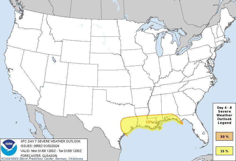
Day 17 15% from SPC. I was looking at Friday, but it doesn't look like instability will be there for strong/severe. Winds for Monday system look impressive.

-
Cool and dry has been pretty boring (HGX AFD's main concern tonight is firework smoke will make local fog after midnight worse, then a half to an inch and a half Tuesday night into Wednesday with a coastal low) but maybe Friday afternoon/evening has a severe threat near and S of I-10. 850 mb winds are not from the SW, but the S. Severe rarely happens near I-10 w/ a SW flow because of capping, but that doesn't look to be the issue.
Of course, CAPE is on the low side, but that can change.
-
46 minutes ago, STILL N OF PIKE said:
I recall in the early 90’s the weather channel had those wind chill maps they ran every hour . The maps were increments of 20f, there seemed to often be -40/-60 upper plains /Minnesota-20/-40 NNE and often -20 to 0 over SNE as I recall . There were often that cold drier clipper pattern with air masses from Siberia or wherever . I do not miss those in the slightest but they did certainly seem more common. I think I recall Dave Schwartz) with his super smooth delivery on many of those
Network news on cold weather, and I think TWC, routinely use windchill maps showing temps in the teens and twenties to hype cold outbreaks. Because actual cold outbreaks where people live just don't get cold enough anymore. Semi-related, GEFS means for next Friday would seem to support snow maybe as close to BOS as 495 with the cold air chasing the back edge of precip to the coast.


Texas 2024 Discussion/Observations
in Central/Western States
Posted
Tomorrow there should be thunder with >7C ML lapse rates, but they won't be surface based. Now, SPC has outlooked a Marginal for Wednesday. Tuesday looks sort of interesting S of I-10.