

Ed, snow and hurricane fan
-
Posts
2,133 -
Joined
-
Last visited
Content Type
Profiles
Blogs
Forums
American Weather
Media Demo
Store
Gallery
Posts posted by Ed, snow and hurricane fan
-
-
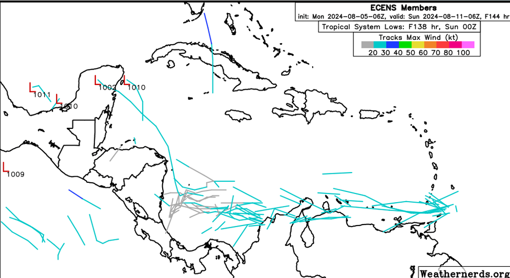
The wave entering the Caribbean, the models are backing off, development is becoming less likley, and the Euro wave after that is recurving before the islands with most of the ensemble members. Its all good, the Gulf can handle a week off from the hurricanes. I'm sure something will get into the Gulf this season, odds are low it is during the next 2 weeks.
-
32 minutes ago, CurlyHeadBarrett said:
Or ironically it might be named francine

The wave entering the Caribbean, Euro ensembles backing off, the wave is too close to South America. The wave behind over the EATL, if ensembles are to believed now (they can change) thatt has fisg written all over it.
-
 2
2
-
-
3 minutes ago, Nibor said:

Last 8 hours. Can really see the wobble in track.
Maybe the NE or ENE is part of that wobble. I think the word used is trochoidal.
-
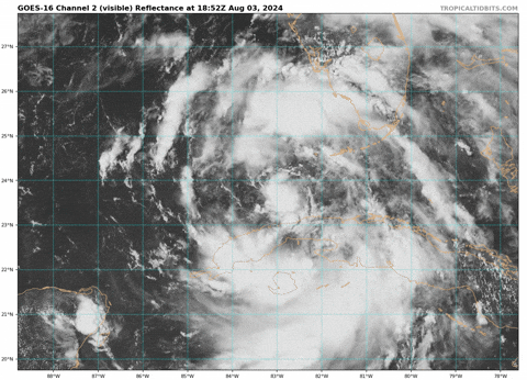
The eye is wonky on radar, making the overall motion hard to follow, but I'm looking at TBW and I think it is moving NE or even ENE.
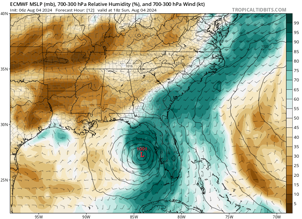
I think the place where NHC is called Alligator Point. I'm pretty sure Debby goes inland E of there. I still think mid-Cat 2 is possible, but if it is more E than forecast, it should have less time over water to do anything too spectacular.
-
My wife hates buying on credit and I don't get paid until the 10th. By next weekend, if the 10/30 lemon is developing and heading anywhere between Veracruz and New Orleans, I suspect the generators will evaporate.
In good news, new GFS says Debbie will literally save the Western Gulf from possible Ernesto.
-
 1
1
-
-
GEFS finally picking up on the NHC lemon.-
 1
1
-
-
At this point, with a defined core and recon data, I'd go consensus of HWRF and the two HAFS for track and intensity. Of course, they are wildly out of agreement with each other.
-
1 hour ago, Prospero said:
Strongest band of the day over us right now. If it were not for Duke Energy replacing all the poles in town last year after Idalia, our power would already be out for days. As it is right now, if we do not lose power tonight me and my wife will be very happy indeed!
We have our flashlights and battery operated fans on hand. The fridge is stocked with beer to be cold. In fact, I will restock what I have had this afternoon...
Wooo doggie! It's a blowin' out there!
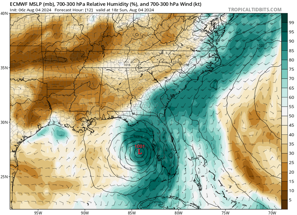
If Houston gets unlucky, at least some of the poles are new, and they had out of state tree cutting crews. Back when CenterPoint was part of REliant HL&P, I'd see tree trimming crews cutting limbs close to power lines, but that stopped at least a decade ago. That Debby is now wrapping moisture around the entire core, now is the time for intensification, even RI.
1 hour ago, wthrmn654 said:She moist in the center now
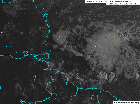
6.2 µm - "Upper-level Water Vapor" Band - 2 km resolution


-
1
-
-
3 minutes ago, wthrmn654 said:
Not for nothing but, of all the models I've seen, the 18z 12k nam starting pressure at 18z today is nearly spot on to current pressure....
Edit! My God, if the 3k were to be right is saying 957mb at landfall, a bit over done.
I think I already mentioned the 3k NAM has a terrible bias towards over-strengthening storms in the Gulf, I see to recall one under 700 mb Cat 14 for a storm in the Gulf. The 3km hurricane models are calibrated for TCs, the 3km NAM is not.
-
1
-
-
54 minutes ago, StantonParkHoya said:
Might be fighting some dry air intrusion?
There is no outflow to the W, even hints of the SW shear in the high cloud motion just W of Debby. There is dry air being pushed in. I watch the Dr. levi Cowan videos, he showed how the European predicted this situation that is happening now. Cowan also mentioned a strengthening storm will moisten the atmosphere W of the storm, and maybe push bad against the shear, but there is still shear into Debby. CIMMS shows shear is dropping toward favorable levels, which will reduce dry air inflow, as Debby builds its upper cyclone.
12Z GFS isn't loading for me on TT. 6Z
-
1
-
-
1 hour ago, CurlyHeadBarrett said:
A gut feeling on a storm in Mexico just S of the Rio Bravo del Norte on one model and following Debby on another, is just a gut feeling. I can gut feeling and split the difference and go with that lone Euro ensemble perturbation that is bringing a Cat 4 or Cat 5 to NOLA, but that is just a guess. Even meteorologists with MS and PhD degrees could guess 9 days out any better than that. If 12 ensembles get it into the Gulf or BoC, than 38 perturbations show either no development or a track close enough to Venezuela that competition for inflow with the South American heat low that lags the effective solar equator and die or don't feel a bent N and hit Central America. The 10/20 NHC probabilities are probably just about right for potential 98L
Development in the Caribbean increases as the heat low moves S following the effective equator, which reduces competition for inflow and weakens the pressure gradient tthat drives fast Low level flow and creates hostile shear. The shear in the Caribbean is less hostile than normal for early August, no doubt the reason some ensembles do develop a storm.
-
1
-
-
1 hour ago, CurlyHeadBarrett said:
what's IMBY
Just N of the Houston city limits but still with a Houston mailing address. I pay Spring ISD taxes, if that helps. I read and post more on TC threads that may come near SE Texas, It is accurate considering the entire state, calling Houston 'Southeast Texas, but for TCs, we should be the upper Texas coast, down to about Matagorda Bay, that mid Texas coast down to around Corpus Christi, and lower Texas coast down to Mexico. But Houston area. 5 days no power with Beryl. I've seen some blue FEMA tarps on homes w/ roof damage out out towards Katy and Cypress, but lots of wind, some of the pines uprooted to snapped, but just limbs in my subdivision.
Ike my subdivision was full of blue FEMA tarps covering holes in roofs. (rooves?)
-
1
-
-
25 minutes ago, wthrmn654 said:
Gfs then brings another "make believe" tropical system from about Cuba up the exact path as derby a few days later lmao...
I think the Gfs,( 12z again...), has lost its marbles or has a few to many drinks at the bar last night..
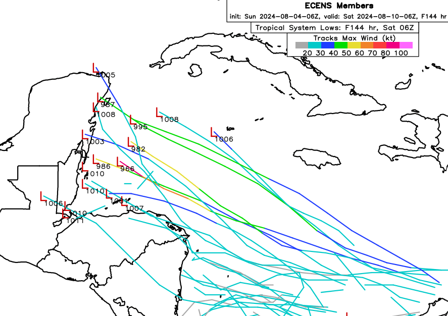
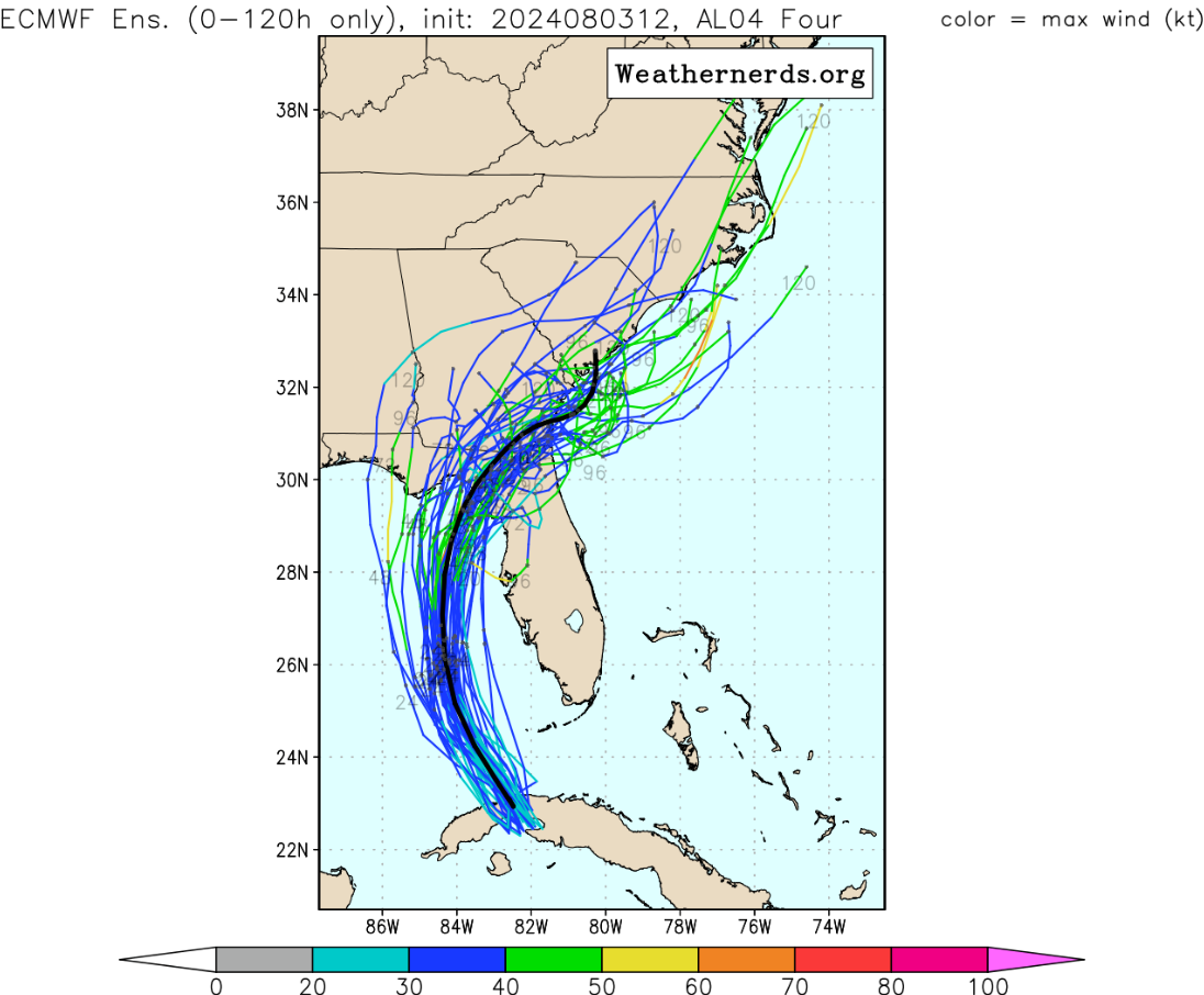
About 40% of the Euro ensembles at 6Z formed a cyclone from the wave around 57W. Half of those stay weak and S, cruise in Central America, and die. Half are heading into the Yucatan at hour 144, and will make the Gulf. The model buildup to Debby started with a few ECENS seeing it, than more ECENS, until finally other models, a few days later, started seeing it. If the Euro ensembles are an indication, the runs that stay well N of the Venezuelan coast get stronger in the C. Caribbean abd head for the Yucatan.
Back to Debby and modeling, I'd expect a bit E of the GFS. Models, for some reason, under react (EDIT SPELLING) to shear pushing the MLF downshear, which drags the LLC along. That puts it over water longer (EDIT TO ADD: longer over the Atlantic), keeps it stronger than a 40 knot storm off the SE Coast, and moves second landfall N, maybe far enough E to miss the OBX. But a stronger second landfall, further up the coast. I'd slide the entire NHC forecast a bit more E, with a stronger TS than forecast.
-
1
-
-
USAFR flight suggests the center is still elliptical N to S (LLC and MLC not quite aligned. I do see on radar (using Werathernerds site) that the center is making attempts at an eyewall, not quite getting there. If the center does tighten up it should have more than a day of 30* + water to strengthen.
-
1
-
-
2 hours ago, CurlyHeadBarrett said:
Those are from yesterday. Today's 0Z and 6Z GFS don't have it, very few of GEFS members develop the wave around 55W. Canadian developed a storm, some enthusiasm from Euro ensembles-suggestion many will hit Central America, ~10 perturbations look to cross the Yucatan or maybe W Cuba and enter the Gulf. I watch potential IMBY systems.
-
 1
1
-
-
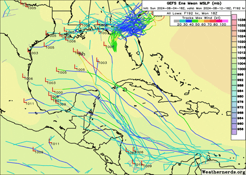
@GaWx I'm about to go to be, church tomorrow. I can't see Euro ensembles currently until after 3 am local. How many ensembles have a tropical system in the Caribbean in 5 to 6 days. Noted above, Canadian actual develops that wave and a week from Monday/Tuesday landfalls Mexico as what is probably a Cat 1 hurricane. Can you describe, or better yet, post? I should be in bed already, but I'm up for another 10 minutes.
-
1
-
-
I assume that shortwave is behind the storms that have been rumbling around Houston for well over 3 hours but haven't produced all that rain.
-
2 hours ago, Ed, snow and hurricane fan said:
Might be time to spend ~ $500 for a portable generator and another hundred or so on box fans. Beryl satisfied the once a decade hurricane here, but return frequency doesn't mean 2 hurricanes in a year can't happen, and a garden variety thunderstorm can knock out my power for two or four hours. I've lived all over Texas, CenterPoint is bad at their job.
Looking at 18Z ensembles and the MIMIC TPW. I spend at least $1000 in 4 days on food and hotels near DFW last time.
Canadian takes the wave that a couple of the GFS ensembles and about a fifth of the 18Z Euro ensembles develop, and move it into Mexico just S of the Rio Bravo del Norte as a 985mb hurricane. I know its the Canadian but I'm pretty sure there have been upgrades, it is no longer 'The Crazy Uncle' from 15 years ago. Gone are the days where several Cat 4 or Cat 5s each year targetted large cities like Miami and New Orleans.
-
 1
1
-
-
Might be time to spend ~ $500 for a portable generator and another hundred or so on box fans. Beryl satisfied the once a decade hurricane here, but return frequency doesn't mean 2 hurricanes in a year can't happen, and a garden variety thunderstorm can knock out my power for two or four hours. I've lived all over Texas, CenterPoint is bad at their job.
Looking at 18Z ensembles and the MIMIC TPW. I spend at least $1000 in 4 days on food and hotels near DFW last time.
-
I couldn't make imgur work, but giphy seems to work.
-
2 minutes ago, Ed, snow and hurricane fan said:
I've been staring at that, and it doesn't look like 13 knots of motion in the advisory.
-
-
4 hours ago, Prospero said:
My first storm was as a kid in 1968 on Charleston Air Force Base with Hurricane Gladys passing by.
All us kids were playing outside when our parents called us in. There was no Weather Channel or online Weather forums. Most people still had a black and white TV with rabbit era antennae. I think my dad was called to fly one of the fighter planes to another base and passed on the news a storm was pending.
Soon as it got dark, lawn furniture started to fly and the backyard became a lake very quickly once it started. An ancient very large oak tree came down which always makes me sad. But I was hooked forever on storms at 8 years old.
")
Gladys came through Pinellas County FL where I live now too.
https://en.wikipedia.org/wiki/Hurricane_Gladys_(1968)
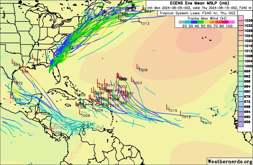
Hurricane Belle, only a Cat 1 before the eye passed over Massapequa after dark. The National Guard ordered us to leave Nassau Shores, Eddie Harkin, work friend of my Dad, at my sisters wedding 20 years later with an oxygen tank, everyone at American Airlines smoked (lung cancer killed my Dad), lived in North Massapequa. My first exposure to cable TV. My dad wouldn't let me go out in the eye. Lots of uprooted willow trees, the ones in the woods not cleared lived on lying on their sides. I have another page and a half of this thread to read. ECENS and GEFS are close for Florida landfall, the somewhat quicker Euro family would be less bad for freshwater flooding.
Euro ECENS (some GEFS support, but not as much, we are about a week away from the next where will the storm in the Caribbean go situation. More on that in general Atlantic thread.

-
2
-
-
[img]https://media.giphy.com/media/v1.Y2lkPTc5MGI3NjExMWhldzg4ZDk3Z291bnFlcGE0bnBnZ3RmaWMzYm83c205Z2tvYmk1dSZlcD12MV9pbnRlcm5hbF9naWZfYnlfaWQmY3Q9Zw/nZhiqdZ8x1kOBWmgOP/giphy.gif[/img]OK, I still haven't figured out how to put an animated gif up here without using half my total file size attachment. I did an extended IR image loop for TT. Anyway, the center seems to be moving due W or just N of due W. I can buy the NHC's 285*. But it needs to turn NW immediately to stay in the center of the forecast cone
2024 Atlantic Hurricane Season
in Tropical Headquarters
Posted
It is further S, closer to South America. There is a heat low over Venezuela that slowly sinks back towards the Equator, In early August, it is still close enough to the Caribbean that it robs inflow, and helps produce the pressure gradient that means higher shear, regardless of the upper level flow. So all the models are backing off on development, and the few that do still develop it are mostly running it into Central America far enough S it never gets back over water.