

Ed, snow and hurricane fan
-
Posts
1,618 -
Joined
-
Last visited
Content Type
Profiles
Blogs
Forums
American Weather
Media Demo
Store
Gallery
Posts posted by Ed, snow and hurricane fan
-
-
I used to drive nuclear reactors in the Navy. I know, scary.
But nuke plants and natural gas plants would be the cleanest source of electricity that didn't depend on wind levels and insolation. Methane is 2 waters per one CO2. Granted, water vapor is also a greenhouse gas, but not to the extent CO2 is. Navy standard nuke plants, not 1970s lowest bidder US plants or Soviet plants, not built in tsunami zones (and simple things like not putting the backup DGs in the basement so storm surge from hurricanes benefitting from record MDR temps) would be safe. Nuke waste is another issue, but fear of waste 2000 feet below the water table in tunnels in the desert is more emotional than scientific.
-
38 minutes ago, weathafella said:
Interesting fact: The last time BOS and metro west was eclipsed by areas south of us down to Philly and parts of BWI/IAD area was the last time we had a strong Nino-until this season so far. I’ll be very surprised if my area gets a single event >6” from now on this season. Looks like I’ll leave my snowblower with plenty of stabilized gas in the tank. I’ll continue the practice of starting it once a month over the summer and fall.
What year was that Nino?
-
17 hours ago, Powerball said:
This weekend will hopefully be the last freeze of the season, and we can transition into Spring mode.
I noticed during Spring Break (all years but one I was working in Austin, but it applied to South Party Island as well) there was usually one final 2 or 4 day break of 40s at night and 50s day, and more seasons than not that was the final really depressing cool (but not cold enough to snow) snap of winter. I remember the Central Texas Easter weekend snow of 2007 (I had to check Google for the year).
-
46 minutes ago, Ginx snewx said:
How we weenie pray
6Z ensembles look so different. Off or on topic, I was in elementary school in the 70s, and at least on Long Island that was a boring period snow wise until the Arctic 76-77 and magic 77-78 winters. February 78 storm, I missed 5 days of Catholic school in Amityville. Wonderful. Our drainage sewers ran to the Great South Bay, and salt water backing up had the 2 feet of snow near the drains green tinged. Wonderful.
-
 1
1
-
-
On 2/15/2024 at 9:06 AM, so_whats_happening said:
I would love to see shipping lanes overlayed on SST anomaly maps in both the Atlantic and Pacific to see if that reduction in sulfur really is playing a large role in these regions. Also bathymetry is tough subject but I am curious if there is indeed something in the subsurface in these regions helping to enhance the oceanic heatwaves more than just stuck patterns.
Joe Bastardi thinks volcanoes. I don't know why he think subsea volcanism is suddenly up the last couple of decades.
-
4 hours ago, George001 said:
One thing im going to be keeping an eye on is how active the hurricane season ends up being. Raindance mentioned a couple years ago that there was a moderate positive correlation between the ACE and east coast snowfall during La Niña winters.
I can't find the post on Space City Weather, but Matt Lanza, a Houston energy sector met, said a strong Nino is usually followed by a near normal hurricane season, but there have been exceptions, such as 2016. Lanza did state the abnormally warm Atlantic MDR temps could make the near normal after a strong Nino correlation fail. I'd also note that the notion of the late 1990s that the 15-20 year active cycles followed by similar length inactive cycles appears wrong based on the general greater activity that started in 1995 having passed 20 years almost a decade ago.
IMBY, we had a once every decade or two cold snap (low temps in the city in the teens) in 3 of the last 4 winters, the one in 2024 being the first I remember in an El Nino year.
-
-
Sam Houston State University and the large Texas correctional complex in the warning,
BULLETIN - EAS ACTIVATION REQUESTED Tornado Warning National Weather Service Houston/Galveston TX 940 AM CST Sun Feb 11 2024 The National Weather Service in League City has issued a * Tornado Warning for... Northwestern San Jacinto County in southeastern Texas... Southeastern Walker County in southeastern Texas... * Until 1015 AM CST. * At 940 AM CST, a tornado producing storm was located over Huntsville State Park, or near Huntsville, moving east at 35 mph. HAZARD...Damaging tornado and quarter size hail. SOURCE...Radar confirmed tornado. IMPACT...Flying debris will be dangerous to those caught without shelter. Mobile homes will be damaged or destroyed. Damage to roofs, windows, and vehicles will occur. Tree damage is likely. * This tornadic storm will be near... Eastern Huntsville and Huntsville State Park around 945 AM CST. Other locations impacted by this tornadic thunderstorm include Oakhurst. -
Is anyone starting an early Spring tornado outlook thread. Assuming the warm ENSO STJ persists, meaning at least a few phased systems, and away from the shelf waters, the GOMEX is warmer than usual, I suspect an active 'Dixie Alley' season.
-
14 minutes ago, raindancewx said:
Nice little snowstorm here in Albuquerque today. My forecast for the city had only ~8.5" before 3/1, I believe with 5.5" in March. This helps catch us up to the former total. We'll likely be at 5-6 at least. Pretty classic setup for us, it was like 39F at 8 am but dew points were like 14F. We tend to snow at approximately ((Temp * 2) + (Dew Point)) / 3, when moisture moves over dry cold air. That was 92/3, so sure enough it has been about 30F the entire period with the snow. The GFS literally never had a single run with snow here, at any point, over the past 7 days. I'm sure you'll all have some surprises downstream with this system when the better sampling comes in east of the Rockies. The 3 km NAM and HRRR did have some nice banding, with localized amounts of 3-6 near/in the city.
I've noticed over the years that these types of snows for us, where moisture moves over cold/dry air tend to have last minute warm noses for you guys at the mid-levels. I'll be curious to see if this turns into a last minute rain / sleet / freezing rain event for someone in the East on the south side of the precip shield.
This little system locks in this winter as meaningfully wetter than average here. We'll almost certainly verify on the warm side. But the cold signal and wet signal are each about 70% likely to verify in an El Nino. So it's quite rare for them both to fail simultaneously.

Semi-OT, but I drove a rental from ABQ to a job interview in Los Alamos in the winter, circa 2000, and crossing the Rio Grande as a small, clean river with snow on the ground around it is a lot different than crossing the Rio Grande at Laredo.
-
40 minutes ago, AstronomyEnjoyer said:
GEFS, FWIW

Is any of that the ensembles moving the storm faster? That doesn't help totals much, of course, but maybe keeps the R-S line fairly stationary.
-
2 minutes ago, Ginx snewx said:
Only thing you posted correct above is antecedent airmass. Next you will tell us the ground will be too warm.
Maybe sun angle will be discussed a few weeks earlier than normal.
-
I-35 corridor from just S of Austin to San Antonio and westward toward the Mexican border has a sig severe hail risk. I'm wondering about Houston tomorrow, little low level instability or shear but >7C lapse rates above a slight warm nose and shear with slight turning but increasing from ~40 knots at 850 mb to 70 knots at 500 mb should mean at least a chance for hail here. Ensembles show a fairly strong looking trough in the sub tropical jet approaching California and the Baja late this week into the weekend. Strong signal on the big 3 ensembles for significant rain down @Stx_Thunder's direction.

-
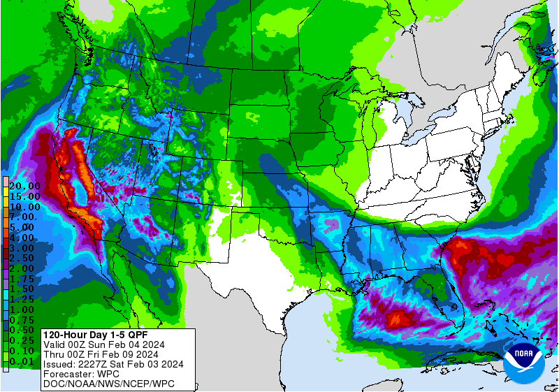
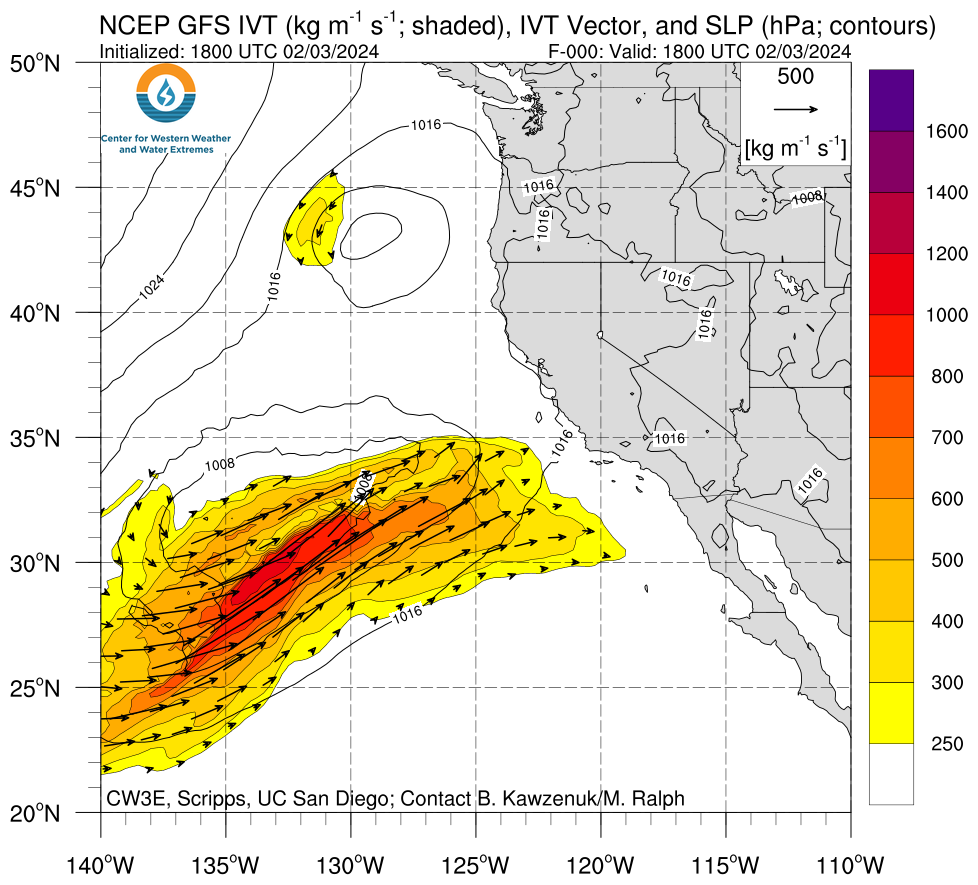
Per TWC yesterday, the next week will be the rainiest week in Los Angeles in 14 years, and most of that falls in 3 days. High Risk of flooding Day 3 in the Los Angeles metro.
WPC disco:
Excessive Rainfall Discussion
NWS Weather Prediction Center College Park MD
154 PM EST Sat Feb 03 2024

Day 2
Valid 12Z Sun Feb 04 2024 - 12Z Mon Feb 05 2024

...THERE IS A HIGH RISK OF EXCESSIVE RAINFALL FOR PORTIONS OF
SOUTHERN CALIFORNIA...


...Central to Southern California...
The latest models are in good agreement on the evolution of a
strengthening cyclone off the central California coast early
Sunday as this low pushes northward towards the northern
California coast.  The strong IVT values that begin to impact the
central California coast late day 1, ~1000 kg/m/s, will persist
into central California coast range, pushing inland into the
northern portions of the San Joaquin Valley and Sacramento Valley
and southward into the Transverse Range.  Strong inflow and
available instability across the area will allow for 1" an hour
rain totals, which would be especially problematic where there are
burn scars.  The probabilities of 8"+ in 24 hours are high enough
to introduce a High Risk for portions of the southern CA
Transverse ranges.  General 3 to 5" areal average amounts likely
in both the Transverse and Central California Coast Ranges, with
maximum totals just over 10" possible in areas of most persistent
training and upslope flow.  Modest expansions were made to the
Slight and Moderate Risk areas.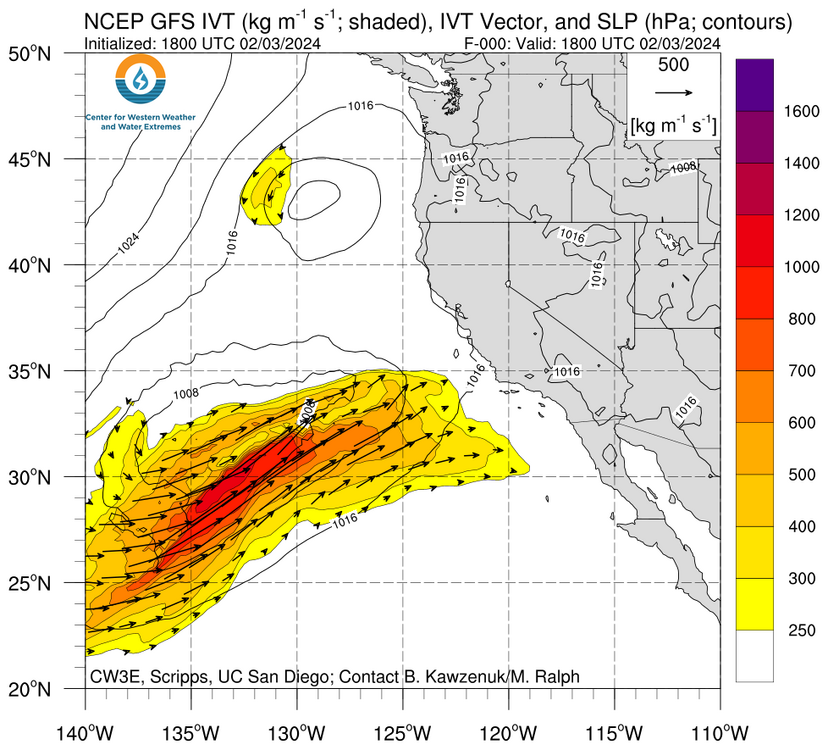
-
31 minutes ago, Stx_Thunder said:
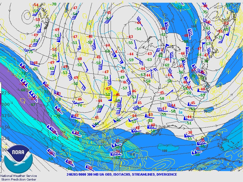
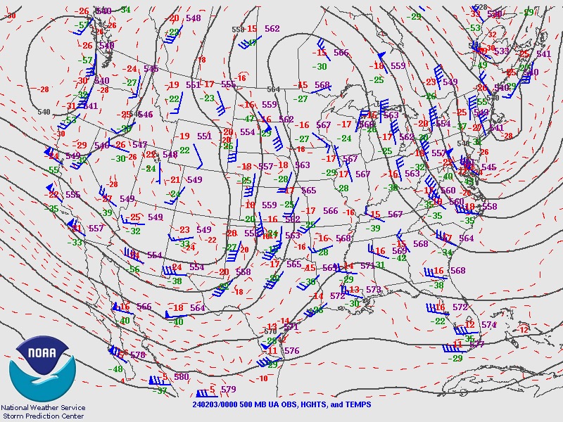
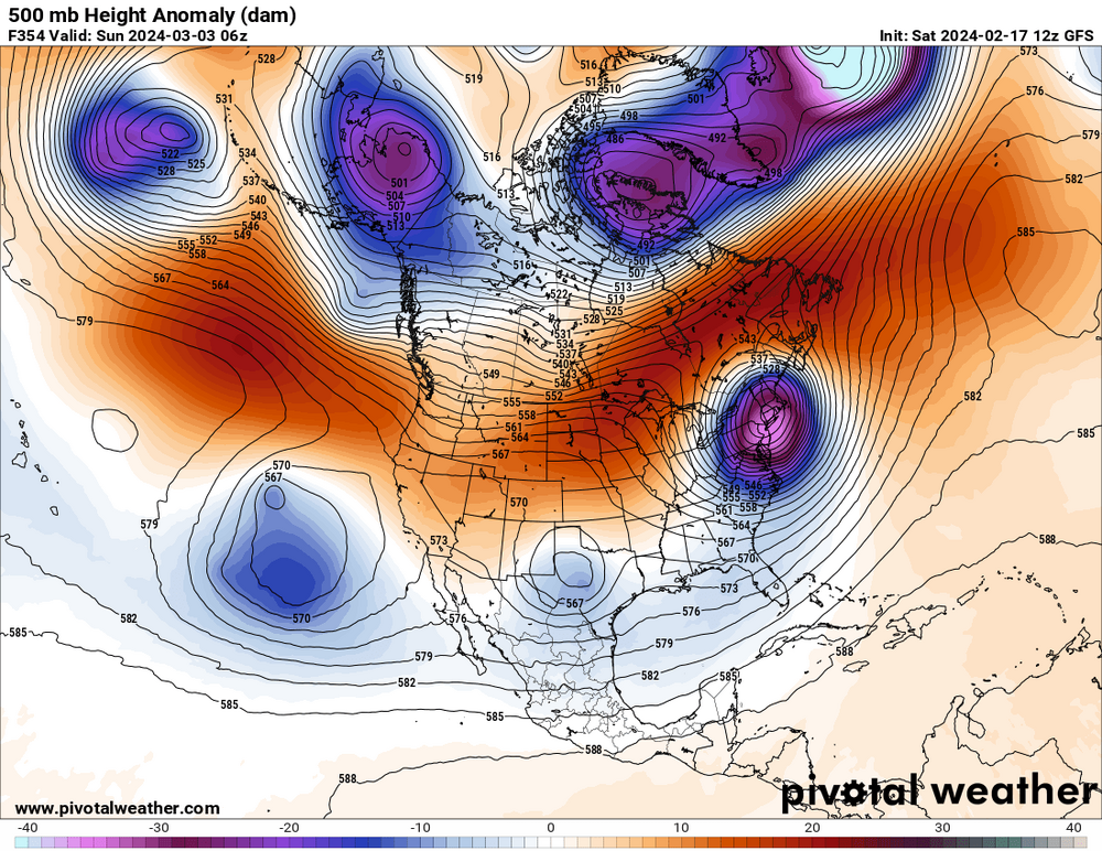
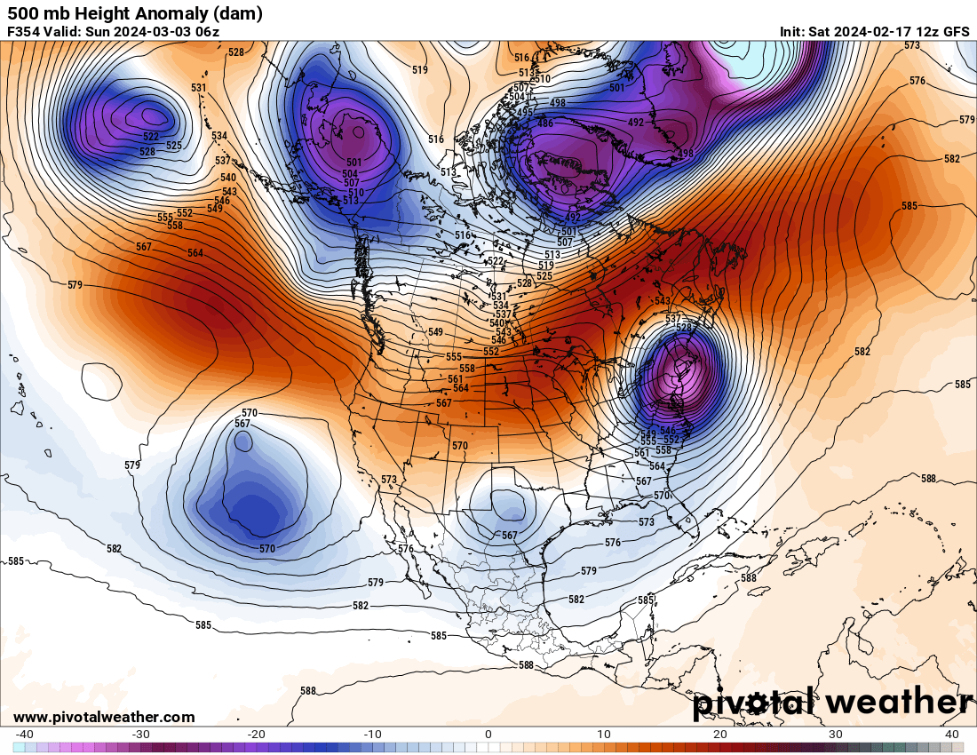
Incoming mid-upper trough into Plains is indeed a bit negatively-tilted (looking at that backed south-southeasterly flow up there in that region) on observed 0Z 500Mb & 250Mb data this evening. That could also be because of that Omega block High that's off to the northeast near the Great Lakes region now. 500Mb Heights are now < 570 in most of TX. And we're pretty much getting into the LFQ down here of that pretty strong ULL jet streak nosing in from the west. So can't rule out some persistent stronger storms through the rest of the night at least over the southern half of state.The clusters in San Antonio region have a good chance of sustaining themselves/becoming more organized toward Houston area with all the SSE inflow going on now around there too on radar VWP in the lower levels this evening. And mid-level LRs are quite steep on 0Z CRP sounding (> 8 C/km between 700Mb & 500Mb) too, but there's that typical stout cap/EML just above 850Mb down here (though it's below 850Mb on BRO). So thunder action again doesn't look too great because of that & the incoming front in STX tonight as they'll likely be more high-based cells like the CAMs were showing since yesterday.

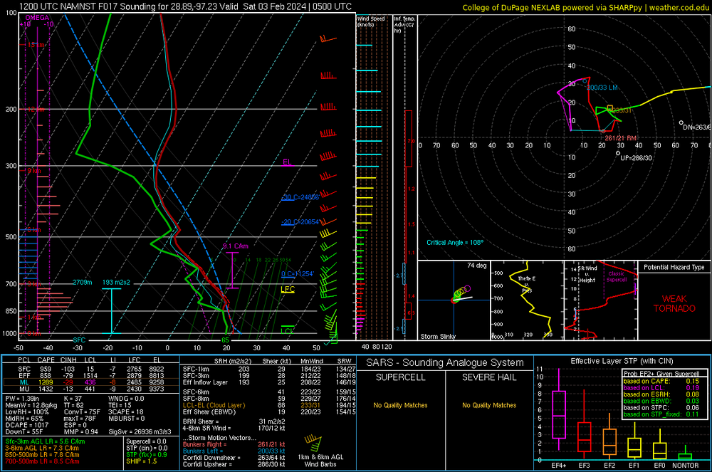
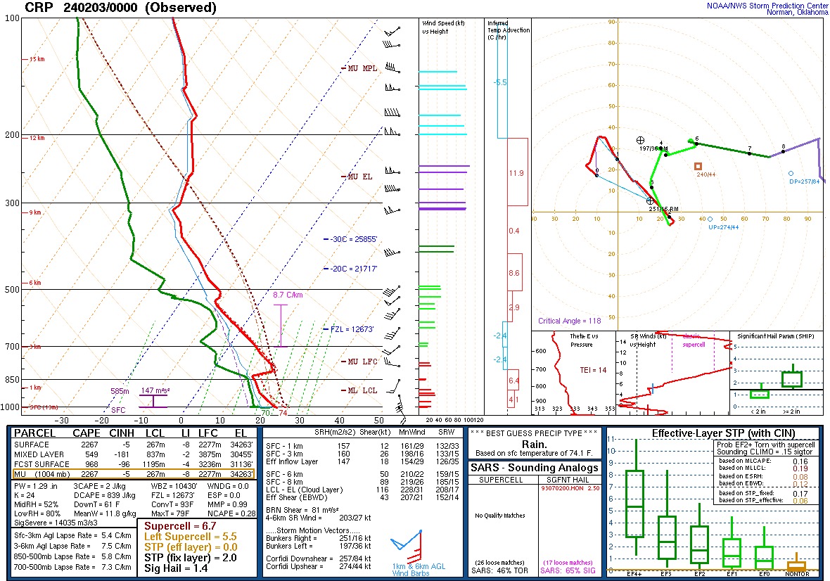
I didn't mention the DYX area tornado was in low 60sF dewpoint, Temps that cool never support surface based severe in HGX. Noticing for years Wyoming having tornadoes with 65/50. cc; @Chinook
Rainfall with earlier storms may exceed forecast Houston area 1-2"
-
44 minutes ago, Typhoon Tip said:
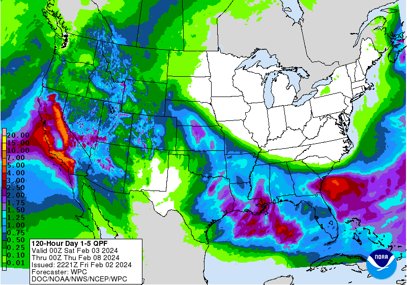
So it’s been 707 days since Logan saw 4” of snow in 24 hrs?
Reminded me, TWC said either 14 or 17 years since Los Angeles had this much 7 day rainfall. Not many California people on this forum, apparently, but this is newsworthy. I was stationed in California in the '80s.

-
1
-
-
Ed from Texas here (family from N. Quincy and I lived in Massapequa, and I've seen snowstorms in both) Voodoo Ranger IPA tastes good and is 9% ABV.
Edible talk, CBD is legal here, THC, not w/o a prescription. My wife, adult daughter, and I, ten years behind the time, shall start bingeing 'Breaking Bad'. We didn't have Netflix back then. I think it was on Netflix. I am a science teacher who now I teaches Algebra, science being more fun, but I'm not teaching in Houston.
EDIT- local news (KHOU), the ever unreliable ERCOT has plans for the loss of solar power during the full eclipse.
-
1
-
 1
1
-
-
Rumble of thunder just now N suburbs of Houston. Earlier than expected. Radar not that impressive. I don't expect severe, it is just too cool (I still don't know how 60sF work further N but not here- confirmed rope tornado with temps in the low 60s), although I suppose marginally severe hail is possible (latest HRRR shows ~1000 mb of MUCAPE. HRRR is less enthusiastic with midnight/just after severe in the AUS-SAT corridor.
-
1
-
-
Oh, hey.
Severe Weather Statement National Weather Service San Angelo TX 536 PM CST Fri Feb 2 2024 TXC207-030015- /O.CON.KSJT.TO.W.0002.000000T0000Z-240203T0015Z/ Haskell TX- 536 PM CST Fri Feb 2 2024 ...A TORNADO WARNING REMAINS IN EFFECT UNTIL 615 PM CST FOR CENTRAL HASKELL COUNTY... At 535 PM CST, a confirmed tornado was located 7 miles southeast of Rule, moving northeast at 20 mph. At 5:31 PM law enforcement reported a rope tornado about 5 miles east of Sagerton. HAZARD...Damaging tornado and golf ball size hail. SOURCE...Law enforcement confirmed tornado. IMPACT...Flying debris will be dangerous to those caught without shelter. Mobile homes will be damaged or destroyed. Damage to roofs, windows, and vehicles will occur. Tree damage is likely. This tornado will be near... Haskell around 540 PM CST. Stamford around 555 PM CST. -
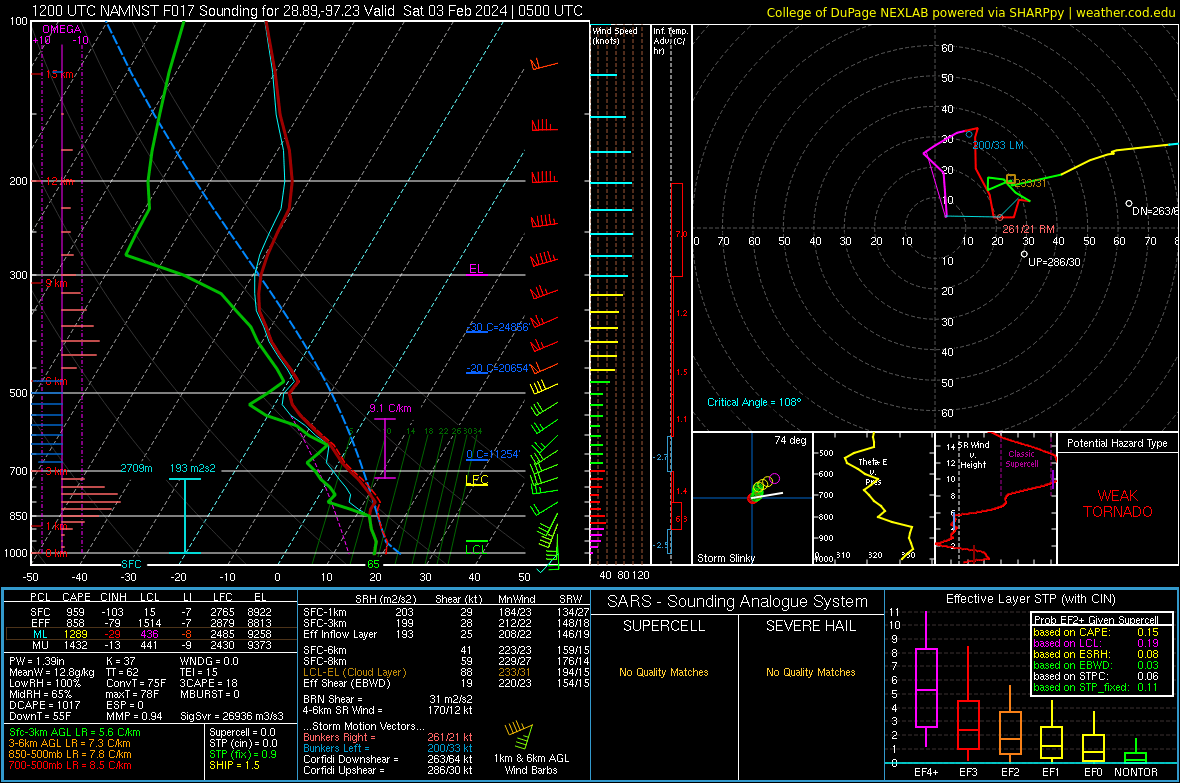
Cells ahead of the main line around Victoria forecast by 3km NAM. Shear isn't impressive above the LFC, but >8C lapse rates (and a TT over 60 because of that), there could be some decent hailers. Later, around San Antonio, a suggestion of embedded cells in the line which might also mean some hail.
-
I'm not pessimistic. I feel Presidents Day 3 coming!
-
Training storms in a SW-Ne axis looking to actually be shifting North from E of SAT up to near SHV. That line will never make Houston, but latest HRRR has more development over S Texas that should be approaching the HOU metro early morning.
-
Speaking of El Nino and IMBY weather- Matt Lanza, reading between the lines, doesn't think El Nino will weaken quite as fast as the models, but even so, since 1950, the first hurricane season after a strong Nino tends to be about average. Although while the recent fronts have cooled the Gulf nicely, the MDR is still abnormally warm. https://theeyewall.com/winter-prepares-to-take-a-break-so-well-talk-about-crawfish-recent-research-and-the-2024-atlantic-hurricane-season/
-
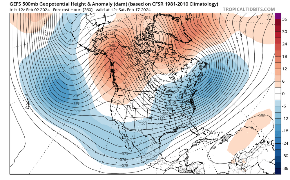
Is there time for the forecast weakening of the Nino (IRI dynamic has it below 1 by mid FMA) to allow for an interesting March weather wise in the I-95 corridor? I don't post much in this thread, I don't know enough about tropical wave forcing to make informative comments or ask informed questions.

El Nino 2023-2024
in Weather Forecasting and Discussion
Posted
1/200 year return frequency on a VEI 6 or higher eruption, the world might get lucky. About 75 years for a VEI 5/Mt. Ste. Helens event, assuming we could get a standard SO2 blast. I suspect some unpleasant weather/climate affects, but it'd knock down record SSTs for a few years, if I had to guess.