

Ed, snow and hurricane fan
-
Posts
1,672 -
Joined
-
Last visited
Content Type
Profiles
Blogs
Forums
American Weather
Media Demo
Store
Gallery
Posts posted by Ed, snow and hurricane fan
-
-
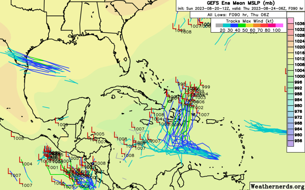
Dr. Andy Hazelton tweeted the Euro and its ensembles in its latest form tend to keep low level vorticity too high when systems are crossing land, or he thinks the Pacific MT to Caribbean to Gulf chances are low. He doesn't say impossible, just not likely.
Derek Ortt, with an MS in meteorology noted a little later, about the same W. Caribbean system, noted GFS and ensembles were slow on Harold, only predicting development a couple of days before it happened. He said the GFS for tropical genesis was for comedy only. They weren't responding to each other.
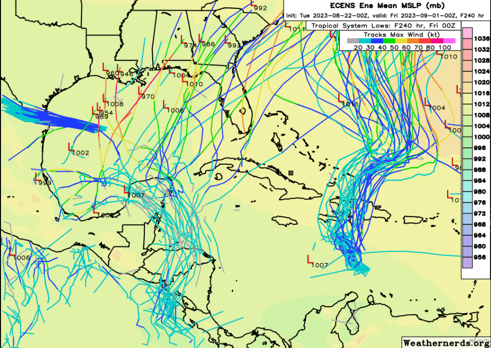
GFS ensembles aren't completely ignoring the W. Caribbean situation, but are much less enthusiastic. 18Z GFS ensembles have a few members in the BOC after 10 days, I'm not certain whether that is a slightly delayed development of the system the 0Z Euro and many of its ensembles like.
-
1 hour ago, Powerball said:
Seems both San Antonio and Houston officially broke their 100*F streak today.
Austin eeked out an intra-hour 100*F before getting an outer band of t'storms from Harold.
Depressing. Today was supposed to be Houston' day to tie 2011's consecutive 100°F streak, and we'd break it tomorrow. A week at least more, Thursday forecast at 107°F. Cloudy, a few showers, upper 90s.
-
Not clear on GFS ensembles, but Euro ensembles have a pretty clear signal of something coming from the Caribbean (maybe from the East Pac) into the Gulf impacting anywhere from Louisiana to Florida. The op Euro also shows it.
-
 1
1
-
-
8 minutes ago, Tezeta said:
whats the deal with popos beach pad? is that still a thing?
Popo passed away, his daughter and her husband have the place. For whatever reason, I have not been waist deep in 85F water trying to catch a small shark or a redfish this year. Only once last summer.
I don't really expect it, but out 2 weeks, the Euro ensemble would seem to have the entire Gulf at risk. The odds that during a brief window, any particular place is hit with a hurricane is pretty low. When I say 10 days from now Florida has a risky pattern, I don't pick a particular city.
We had an excuse in 2009 not to go to GLS, there was no place to go. This summer, both my wife's grandparents are dead, they invited us down often, my wife's aunt hasn't invited us lately.
-
Houston can tie 2011 at 24 consecutive 100F days (remember, we have cooling breezes off the Gulf, it just doesn't get as hot) if the clouds on the edge of TD 9 don't limit insolation. NWS Houston has the 6 days after tomorrow well above 100F.
Since it won't rain here, I say lets have a new consecutive 100F day record. By 10 days, the death ridge is shifting W and I think the temps should drop closer to normal temps.

-
I think there is a real chance for a hurricane, possibly a long tracked major, the end of the month and the beginning of September. The Atlantic ridge this far W, Florida, and the SE USA, would be favored. GFS ensembles not radically different although beyond 240 hours has less of the Atlantic ridge into the Gulf than the Euro ensembles do.
Euro ensembles, go out to 2 weeks, the Atlantic ridge is nosing even further W, opening up much of the Gulf to long tracked MDR storms.

-
I only wish I knew where in California. Stationed there 4 years then had a summer job in Bakersfield in 1992.
-
108°F in Houston, breaks the daily record from 1909. No rain in almost 6 weeks, could approach 8 weeks per ensembles. Hawaii has already had a major fatality fire episode. Washington state has wildfires. Texas wildfires so fall small, but we are soon to pass 2011 records for drought and heat. The 2011 Bastrop fire alone, in a rural county, destroyed almost 1800 homes.
SPC issues fire weather outlooks, NWS offices have fire weather discussions. As a starter, Austin should receive no rain from 91L, but the NWS forecast is 20 mph gusting to 30. Austin has already had residential buildings destroyed by wild fire.
-
4 hours ago, GaWx said:
Bell ringing day last year vs this year:
Last year: very quiet despite moderate La Niña
This year just about as many systems at one time as ever despite moderate El Niño:
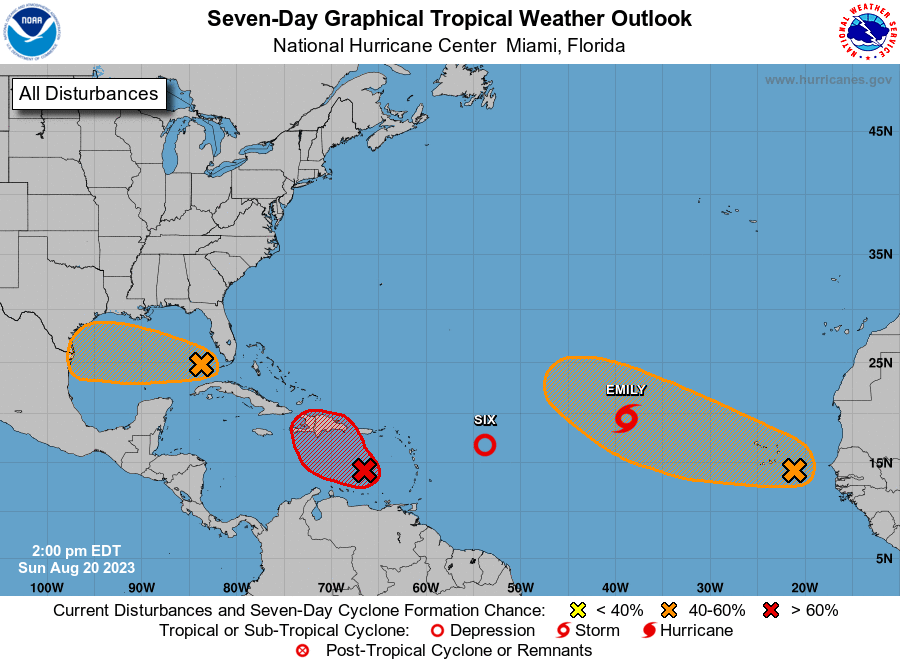
Did we have 2 systems upgraded to named storms in a single day last year? Of course not. I think we'll have 3 named storms in 3 days, but the numbers will be 3/1/0 for August, Maybe 4/1/0. I think a below normal numbers and ACE season, but nothing like the LDub season cancel. Gulf has poor steering and shear/dry air, but I'd bet money on a major hurricane landfalling Florida in October. The OHC will still be immense in 2 months, and normal (climatological) mean steering favors Gulf to Florida. Probably not a storm with enough lifespan to make ACE normal, but a short lived Cat 3 or 4 is a Cat 3 or 4. Looking for a model that supports thay, none so far.
-
108°F in Houston, breaks the daily record. Nearby Houston-DW Hooks, a private airport, 109°F
This we site will be active soon. https://public.tfswildfires.com/
-
1 minute ago, Ed, snow and hurricane fan said:
NWS was wrong, Accuweather was right, 107°F at the big airport, tying the daily record from 1909!!!!! Edit to Add, a tie for Houston's daily high. We still have an hour...
111°F at Aggieland. That is warm.
-
NWS was wrong, Accuweather was right, 107°F at the big airport, tying the daily record from 1909!!!!! Edit to Add, a tie for Houston's daily high. We still have an hour...
-
I see no modeling that gets 91L above a TS, but my mind wouldn't be blown if it makes it to a 65 knot hurricane. Vis shows good outflow in all quads but the S. Not Weenie-casting, if I were it'd be headed for my house with 3 or 6 inches of drought busting rain (if just a Cat 1), or a major S of Port Lavaca with Reed Timmer and Josh Morgerman chasing it. With at least outer bands raining on my yard.
None of that will happen with 91L.
-
Initial low skill models suggest 91L may take the big tour around the death ridge and may enhance the monsoon rains over areas already affected by Hilart.
Nothing in California as far as power outages, but TWC is showing their map that will show when power goes out. Which might be more flood related than wind causation. On satellite, Hilary is starting to look like a TC in the higher latitudes, which deep convection N of the center. 32N isn't high latitude on the E Coast, I don't know if it is shearing from the S or cooler water.
-
GFS keeps Houston completely dry, so I'm less weenied than I would otherwise be for a invest in the Gulf. But the initial deep steering model looks like what 91L becomes goes for almost a complete ride around the death ridge.

-
Most of the GFS ensembles curve this N into the Atlantic, but there are some weaker ensembles that get it into the W Caribbean. Not an obvious Gulf threat, the death ridge should keep anything moving W, but still interesting.
-
51 minutes ago, Powerball said:
It's already 102*F at DFW as of 11am...

Supposed to be 106° (107° per Accuweather) today but I don't know, only 93° at the big airport. NWS is only 97° on Tuesday, but because a 30% chance of showers although 12Z GFS is completely dry, Ensembles are almost a tenth of an inch. NWS disco said if we do make the century mark, to use their words, we won't just break the record for consecutive days from 2011, we'll smash it. NWS disco also mentioned the enhanced fire danger Tuesday because it will be windier. 2011, the big fire in Bastrop started with drought weakened trees dropping branches onto powerlines as Lee, sheared and without rain on its W side, caused gusty winds. 25 mph gusts forecast. May not drop tree limbs, but would help spread any fire.
-
1
-
-
It looks like shear and mid-level humidity don't look terrible, but there seems to be an almost exposed center, although latest images thunderstorms are trying to build North. May be partially exposed, but that looks like a closed tropical low to me.
-
1
-
-
NWS forecast is 106°F in Houston, if it is going to be that warm, I'm hoping the Accuweather 107°F is correct, as it would tie a 114 year old record for the date. 18Z GFS ensembles are no rain at all here for the tropical wave.
But the GEFS gets us almost to half an inch or rain by hour 384.
-
5 hours ago, Stx_Thunder said:

WPC now also indicating a marginal excessive rainfall risk on the day 5 outlook for most of TX coast region on Tuesday. If it develops a 500mb circulation (regardless of any TC development), the risk would likely be upgraded as a Mid-level Low does create better support for lift and deeper (tropical) moisture advection aloft for more organized deep convection on the northern region.
It should keep a steady track through the Gulf (mid-upper level high not too far off to the north providing stronger steering flow) that some shower/storms could start coming onto the southern TX coast by this Sunday.
Congratulations in South Texas. Nice drought denter. A quarter inch of rain will be the first rain in Houston since 4th of July weekend, and won't do much. Trees are starting to look sick, the grasses are brown. Just need a couple of windy days to start several large wildfires.

-
 1
1
-
-
1 hour ago, WxWatcher007 said:
Euro, GFS, and CMC all have something trying to come out of Central America/EPAC into the basin late next week. It’s entirely irrelevant how strong those op runs strengthen something in the long range, the signal is what matters. There are a lot of moving pieces here.
Some Pacific basin lows cross into the BoC. I think the Euro ensembles are too juiced this year, but getting a named storm from the Pacific to cross basins would be different.
-
Recon data usually updates fairly often on Cowan's Tropical Tidbits page. Looks like the plane has descended to mission altitude. https://www.tropicaltidbits.com/recon/
-
24 minutes ago, WxWatcher007 said:
Both 98L and 99L look like they have a low level circulation going, but are struggling with dry air nearby.
It looks like the lead MDR area (lemon) is also trying to spin independently but has a lot of work to do. I’m intrigued by this one because it’s south of shear and dry air and remains convectively active, though very disorganized.
As we’ve seen with successive diurnal cycles, convection is picking up again with the disturbance that’s now entering the Bahamas. Nothing much there yet though. It is entering a low shear environment, so we’ll see what if any organization can occur before the Gulf, not because I anticipate anything other than rain for Florida, but because even modest sharpening of the wave can open the door for slightly faster development in the Gulf.
Looking at the CIMSS product, the best low-mid level vorticity is a bit S of the convection, with the max vort over E Cuba. I hope convection can pull vorticity N, I want a NW Gulf system that breaks all month no rain/100F here in SETX. Modelling is shifting S towards the Texas Coastal Bend, which doesn't help me. I can now see it on MIMIC-TPW product, it wasn't so obvious before.
In the MDR, 99L looks better to me on satellite, but 98L looks better on the TPW loop. https://tropic.ssec.wisc.edu/real-time/mtpw2/product.php?color_type=tpw_nrl_colors&prod=natl×pan=24hrs&anim=html5
-
1
-
-
6 minutes ago, Eskimo Joe said:
Positive side of heavy rain in the desert, the resorts around the Salton Sea were abandoned in the 60s and 70s as the lake levels dropped, maybe it will bring back tourism.
On the more serious side, I watch engineering disaster shows, and desert highway bridges over arroyos secos have a bad habit of collapsing in the ever more frequent once in a century flood. The stream beds often change course and wash out where protective 'rip rap' wasn't placed. Interstates like 5, 15 and 10, all vital routes, could be closed.

2023 Atlantic Hurricane season
in Tropical Headquarters
Posted
It seems to me there are few patterns where some part of Florida isn't at risk of a TC landfall June to mid November.