

Ed, snow and hurricane fan
-
Posts
1,665 -
Joined
-
Last visited
Content Type
Profiles
Blogs
Forums
American Weather
Media Demo
Store
Gallery
Posts posted by Ed, snow and hurricane fan
-
-
8 minutes ago, schoeppeya said:
Storm has wrapped convection all the way around the circulation including the ups head side, not convinced it’s not off to the races
Fading light on the vis loop shows a big explosion over the center.
-
On 8/26/2023 at 9:00 AM, Windspeed said:
Sorry, bro. Better practice Idalia. Like a vidalia onion, only no "V"....
Like a Vid-AH-li-a onion, it is a Spanish name. All the English ones have been used. Finnish has some good I names.
-
 1
1
-
-
107° headed for 110°, but HGX radar showing some little cells popcorning to the N of Houston, and GRK showing more in the pipeline.
-
7 minutes ago, Tallis Rockwell said:
You mean the sub 895 mb hyperstorm?
The 12 km, obviously.
-
8 minutes ago, WxWatcher007 said:
It looks fine to me. This is the only active flight.

Mission 3 is at the top of my TT recons. I see #2 at the bottom now that I looked down the page. It doesn't take much to confuse me. Speaking of, nobody seems to think well of the NAM as a tropical model, but 30 minutes to the 18Z run. Be interesting to compared 12Z and 18Z. More interesting to compare the globals, of course.
-
8 minutes ago, GaWx said:
Regarding that Tweet assuming he is excluding both the Big Bend and Tampa, themselves, when he says "between", it would be extremely difficult though not impossible for Idalia to cross the coast in that stretch because most guidance shows it still moving NNE at that latitude and that part of the coast is angled NNE. October, when headings are more commonly NE to E, is usually a more dangerous period for that to happen.
I was a JB subscriber for Charley, he predicted landfall farther S than TPA area because of angle of approach and land interaction, he was correct, it seemed to happen again with Ian. If this is forecast to almost parallel the Florida coast I wouldn't be surprised if it made landfall further S than the models would have suggested. Edit to add- Euro ensemble paths a bit less oblique than prior mentioned storms, so it may not go S of models.
-
1
-
 1
1
-
-
51 minutes ago, WxWatcher007 said:
I’d take this to mean that we did get valuable storm structure data for 12z, but much more will be coming in subsequent model suites with high altitude and low level recon continuing through the day and evening.
Did NOAA 9 G-IV have a problem, it looks like it turned around looking at TT
-
9 minutes ago, Windspeed said:
First graphic for posterity...

Minimal Cat 1 about 12 hours before landfall. Anticyclone over the top on 12Z GFS should keep the dry air to the W and SW from mixing in too much, I'd guess strengthening until landfall. It might be a Cat 1 more than 12 hours before landfall, of course.
-
First major of the season tomorrow. I don't follow ACE that closely during the season, but lots of names and not that much ace, between Franklin and TD 10 which I'm guessing becomes an H, come closer to the 130 to 160 forecasts I've seen.
-
1
-
-
NWS forecast is 108°F tomorrow, but my daughter said the TV forecast (she thinks it was AccuWeather, that would be Channel 13) said an all time record of 110°F 20% chance of storms. I didn't think it was possible to have a ridge strong enough for that kind of heat and have convection. When I lived in DFW, the really hot days there wasn't a cloud.
-
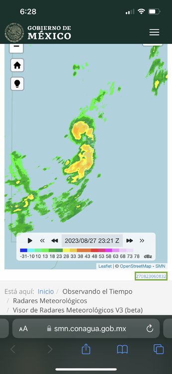
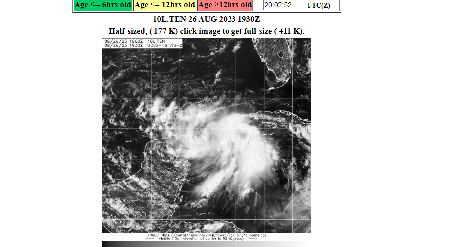
Navy satellite site has TD #10
-
Does this look like it will spend much time over the Yucatan as models seem to be implying?
-
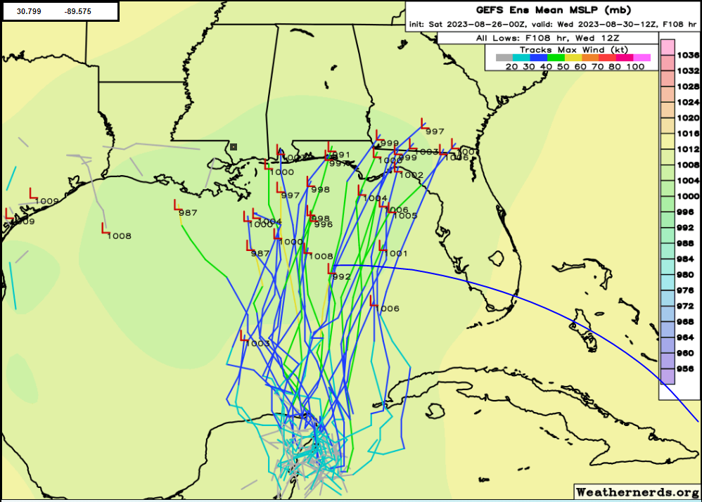
I think Charley is the closest big storm I can think of, although it came through the Caribbean and was stronger on approach. Michael as far as landfall compared to GFS ensembles, but August to October makes a deal. If the shift W on ensembles continue, eventually Mississippi and New Orleans could wind up as areas of interest. Euro and ensembles will be interesting. If I wake up in the middle of the night
-
21 hours ago, Powerball said:
Houston apparently made it to 109*F
Meanwhile, DFW broke more records as well with a high of 107*F and a low of 84*F (previous records were 106*F and 82*F respectively in 2011).
And thunderstorms developed at dusk. IAG got 0.01, the first measurable rainfall in 7 weeks, I'd guesstimate half an inch on the lawn, and there a lot of wind. Electricity came back at 2 am. Sleeping w/o AC, how did people survive the 19th Century?
40 degree T/Td spread, 2 reports to SPC for wind in Harris County.
-
1
-
 1
1
-
-
13 hours ago, MJO812 said:
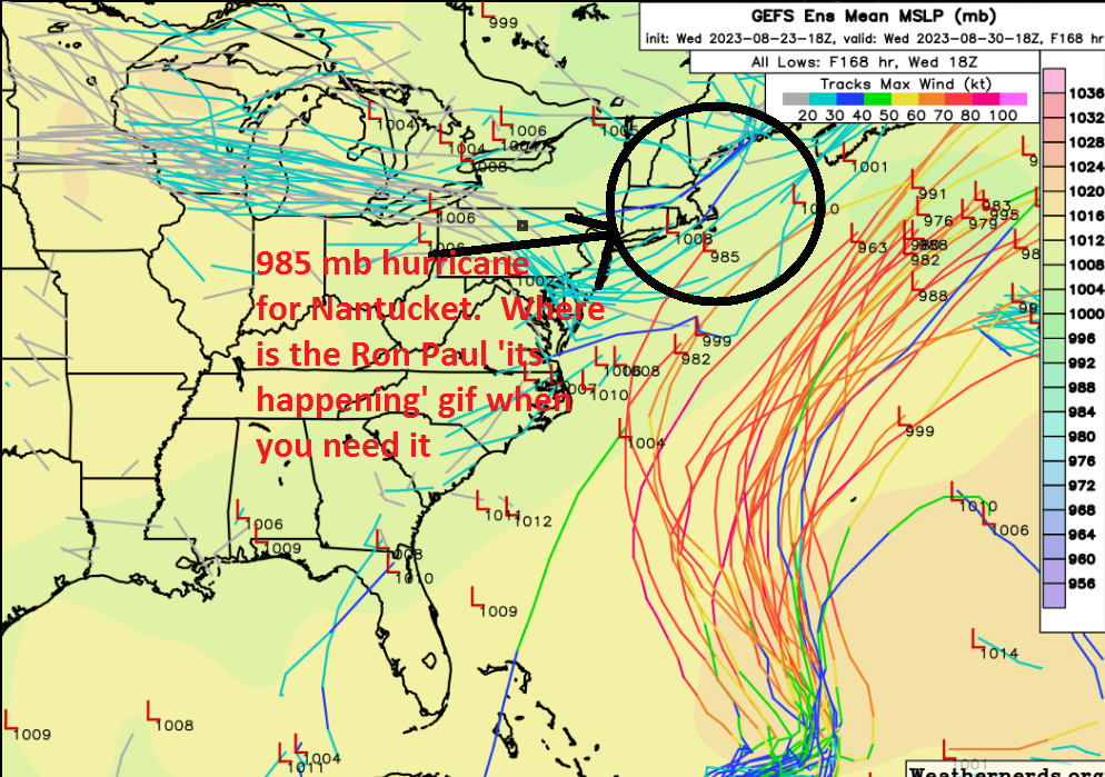
Looks like no threat to the US despite what some people are saying on social media .
Yo be fair, I posted to Twitter/X, with a zoomed 18Z GFS ensembles with a 985 mb headed for Nantucket. Sure, it was the leftmost outlier, but #MAwx people need some excitement. I actually think the W. Coast of Florida, or maybe the E Gulf, is likely the only US hurricane threat area, if not next week, in late September or October. I feel safe in Texas. Which is good, I wasn't as fat, and didn't need CPAP after Ike. Didn't lose power during Harvey, but parishioners at our church drowned during Harvey, and I do use CPAP now. Now I just weenie, just a little, for other people's storms. I'll still weenie for a Houston winter weather event.
-
18 minutes ago, CoastalWx said:
Seems like you’re drinking now.
Just 2 beers after work.
-
My family spent 2 weeks in a big rental house. Twice. Late 1970s. Harwichport. The models are coming my way. Nantucket cane, its not an outlier, it is the beginning of a trend.
My first time drunk. My parents went out, I had found the owner's Manischewitz. Not a big bottle, but 15 or 16, never drank before.
-
 1
1
-
-
1 hour ago, Stormchaserchuck1 said:
15-day GFS ensembles are going all out -PNA though, which may put a ridge over the SE, US in time for a part of peak season. If a ridge sets up over the NE/SE Canada, that makes Gulf and SE landfalls more likely.
It seems to me there are few patterns where some part of Florida isn't at risk of a TC landfall June to mid November.
-
2
-
-
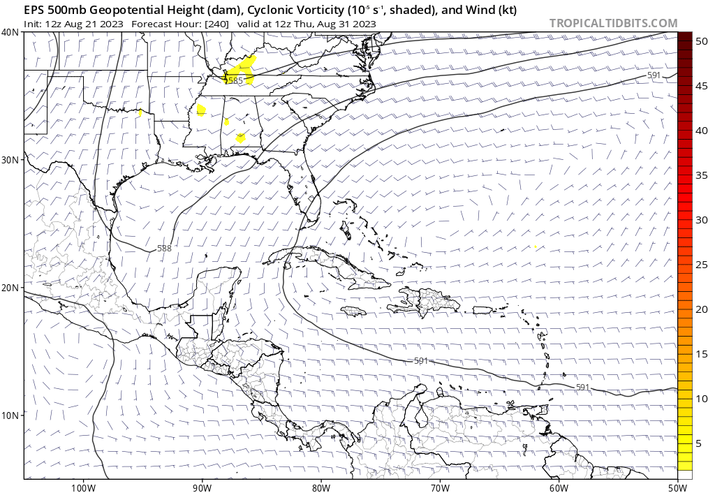
Dr. Andy Hazelton tweeted the Euro and its ensembles in its latest form tend to keep low level vorticity too high when systems are crossing land, or he thinks the Pacific MT to Caribbean to Gulf chances are low. He doesn't say impossible, just not likely.
Derek Ortt, with an MS in meteorology noted a little later, about the same W. Caribbean system, noted GFS and ensembles were slow on Harold, only predicting development a couple of days before it happened. He said the GFS for tropical genesis was for comedy only. They weren't responding to each other.
GFS ensembles aren't completely ignoring the W. Caribbean situation, but are much less enthusiastic. 18Z GFS ensembles have a few members in the BOC after 10 days, I'm not certain whether that is a slightly delayed development of the system the 0Z Euro and many of its ensembles like.
-
1 hour ago, Powerball said:
Seems both San Antonio and Houston officially broke their 100*F streak today.
Austin eeked out an intra-hour 100*F before getting an outer band of t'storms from Harold.
Depressing. Today was supposed to be Houston' day to tie 2011's consecutive 100°F streak, and we'd break it tomorrow. A week at least more, Thursday forecast at 107°F. Cloudy, a few showers, upper 90s.
-
Not clear on GFS ensembles, but Euro ensembles have a pretty clear signal of something coming from the Caribbean (maybe from the East Pac) into the Gulf impacting anywhere from Louisiana to Florida. The op Euro also shows it.
-
1
-
-
8 minutes ago, Tezeta said:
whats the deal with popos beach pad? is that still a thing?
Popo passed away, his daughter and her husband have the place. For whatever reason, I have not been waist deep in 85F water trying to catch a small shark or a redfish this year. Only once last summer.
I don't really expect it, but out 2 weeks, the Euro ensemble would seem to have the entire Gulf at risk. The odds that during a brief window, any particular place is hit with a hurricane is pretty low. When I say 10 days from now Florida has a risky pattern, I don't pick a particular city.
We had an excuse in 2009 not to go to GLS, there was no place to go. This summer, both my wife's grandparents are dead, they invited us down often, my wife's aunt hasn't invited us lately.
-
Houston can tie 2011 at 24 consecutive 100F days (remember, we have cooling breezes off the Gulf, it just doesn't get as hot) if the clouds on the edge of TD 9 don't limit insolation. NWS Houston has the 6 days after tomorrow well above 100F.
Since it won't rain here, I say lets have a new consecutive 100F day record. By 10 days, the death ridge is shifting W and I think the temps should drop closer to normal temps.

-
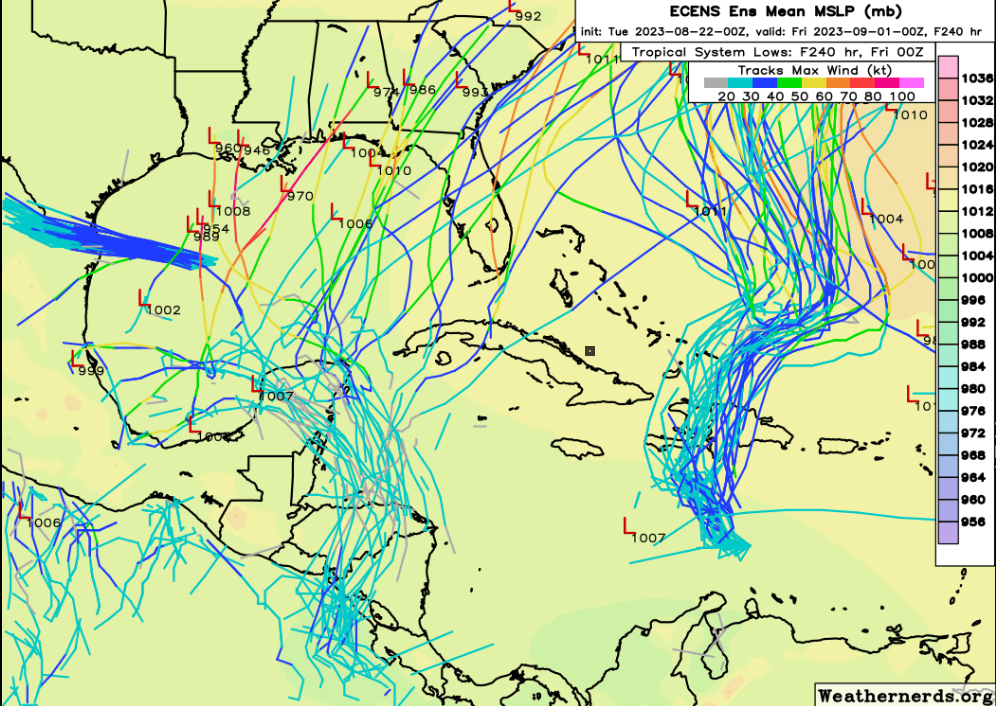
I think there is a real chance for a hurricane, possibly a long tracked major, the end of the month and the beginning of September. The Atlantic ridge this far W, Florida, and the SE USA, would be favored. GFS ensembles not radically different although beyond 240 hours has less of the Atlantic ridge into the Gulf than the Euro ensembles do.
Euro ensembles, go out to 2 weeks, the Atlantic ridge is nosing even further W, opening up much of the Gulf to long tracked MDR storms.


Hurricane Idalia
in Tropical Headquarters
Posted
I could be wrong but I *think* recon found N-S elliptical eye 12 km x 8 km. EDIT- I think it is 12 nm x 8 nm.