

Ed, snow and hurricane fan
-
Posts
2,133 -
Joined
-
Last visited
Content Type
Profiles
Blogs
Forums
American Weather
Media Demo
Store
Gallery
Posts posted by Ed, snow and hurricane fan
-
-
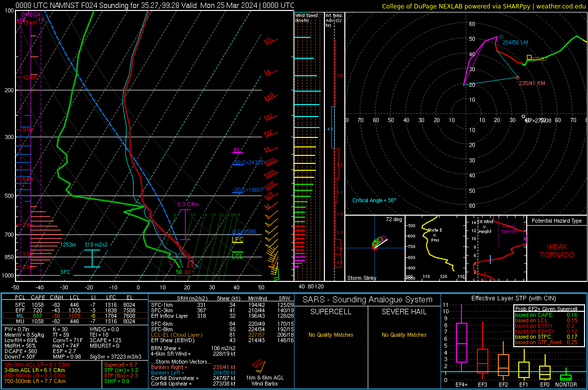
Not hatched for large hail, but enhanced risk for hail probs >30% w/i 25 miles for a small part of N Central Oklahoma and S central Kansas on updated SWODY1
-
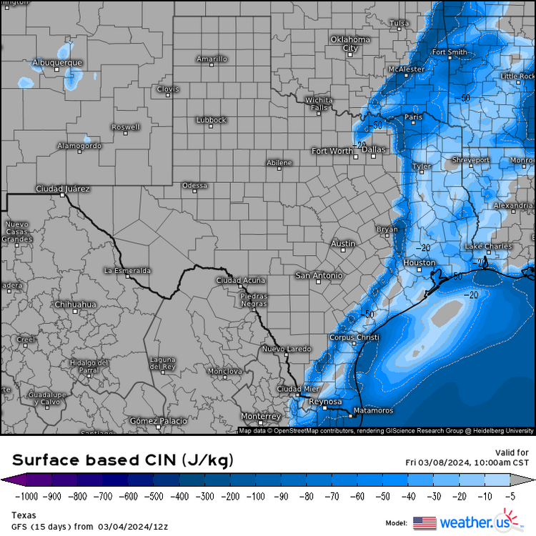
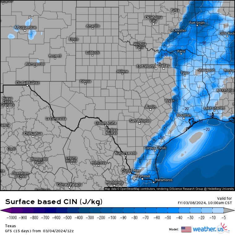
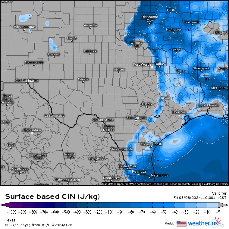
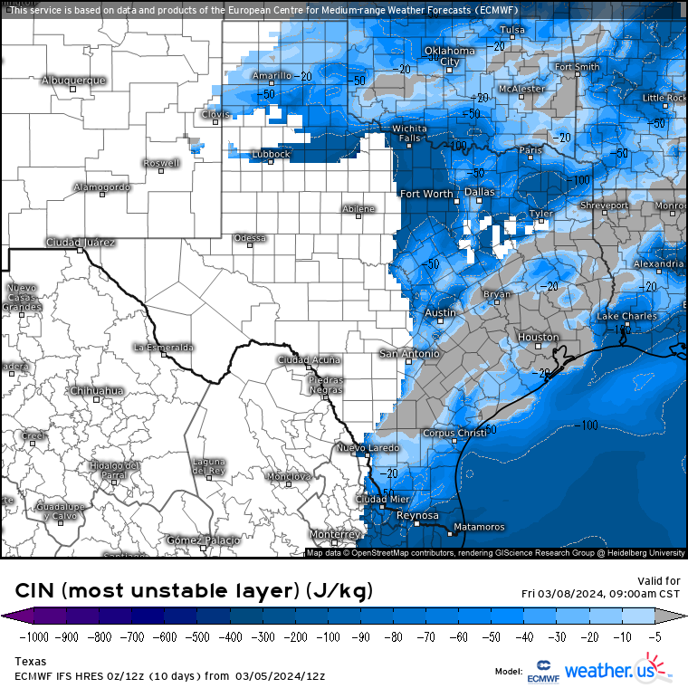
Sunday looks more like a day for chasing hail and structures. Surface based CAPE is fairly low, surface CINH is fairly high. Maybe W. Oklahoma might see a tornado or two, if I had to guess.. Impressive ML lapse rates though, and there is enough plenty of shear. Looking at Day 2 area HRRR and 3 and 12 km NAM, a squall line with gusty winds seems more likely judging my simulated radar, although there is some surface based instability and a lot of low level shear. Maybe embedded in a line, or a cell ahead of the main line.
-
In a severe warning at 6:30, fair amount of lightning but no hail or strong winds. No warnings but impressive line segment NW of San Antonio currently.
-
I was staying about 10 miles S of the supercell Thursday. I watched it developing when I was doing the tourist FTW Stockyards, and their cattle drive of 10 or 12 longhorns who were clearly sedated.
-
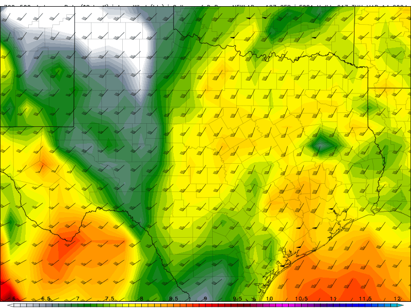
I haven't seen VIL used as a large hail proxy in a while, but latest HRRR would seem to be dropping big hail with a deviant right turner towards Kingsville, where I have partied with college students from the local branch of the ag college. 3 km NAM in general agreement of generally calm until what I assume is a shortwave crossed the Rio Grande into South Texas around midnight.
It might have been the Texas thread, but I commented to @Stx_Thunder that while Deep South Texas doesn't have the North Texas/Big Country/Panhandle reputation, it can have the occasional 'gorilla hail', that would get more attention if the population density away from the border towns was higher. Tonight might be one of those events.
-
On 2/18/2024 at 10:13 AM, ice1972 said:
Correct - when I got back from Missouri in 2017 after the last one I had a ton of people making fun of me for spending the time and money to go to the middle of the country to see it……their reason was “oh it was like 90% here and it was so meh - what’s the big deal?”…..I would always say “it can’t be explained - when you make it to the center line you’ll know”…..really annoying the ignorance
Billboards on I-45 in Corsicana, a third of the way before DFW and Houston advertising the eclipse. Not sure that would be a destination. San Antonio and Austin probably have the most other tourist-y things to do in full eclipse areas of Texas. I'll be working and will not be allowed to go outside, except maybe for a three minute break.
-
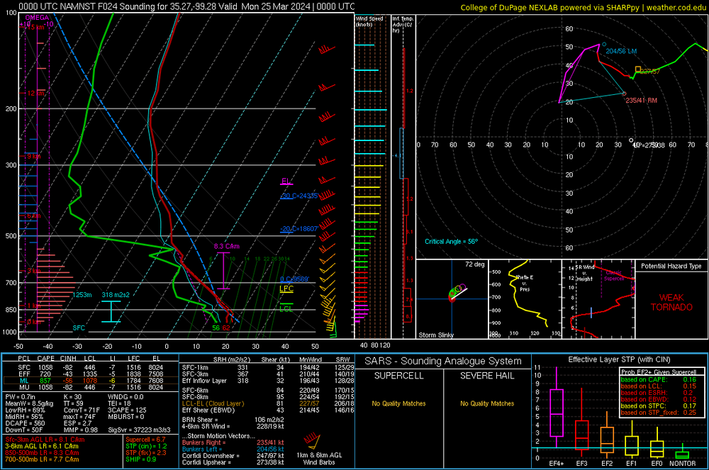
Visiting family in HEB area of DFW. Expecting storms to fire pretty much overhead late afternoon and mature as they move E past us. 3km NAM shows >4000 J/Kg MLCAPE just E of here. I expect the storms to mature quickly, updraft helicity after storm initiation down here less impressive than I'd have expected.
If I see anything cool, I'll snap storms to the E lit by the early evening light and post them.
-
 3
3
-
-
80% SPC watch probs NE Kansas and NW Missouri. By NE Kansas, I mean not just a corner, meso bubble almost to Hays.
-
3 hours ago, raindancewx said:
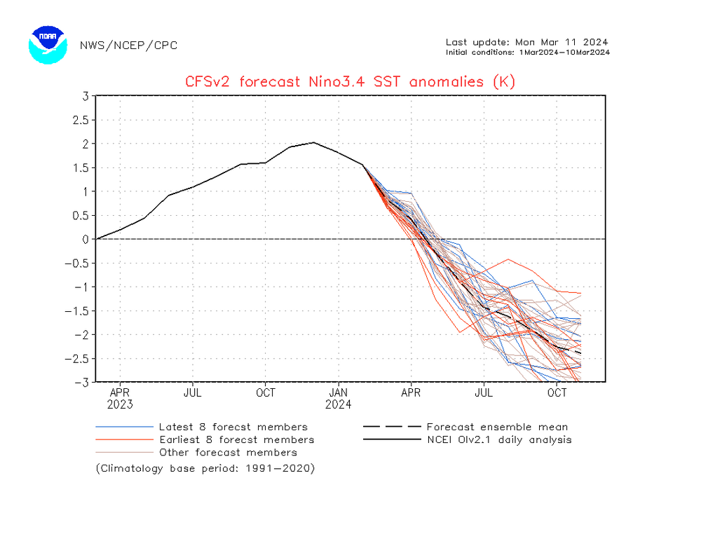
The El Nino finished at ~28.4C in Nino 3.4 for Dec-Feb. The years most similar to that were 1957-58, 1972-73, 1982-83, 1991-92, 1997-98, 2009-10. The roll forward is very much a Modoki La Nina look if you throw out 1958 and 1992 which are not La Ninas.
1973-74, 1983-84, and 2010-11 are actually pretty interesting winters with pretty severe cold shots at times in places you wouldn't expect given the overall patterns. I believe 1983-84 and 2010-11 had TX power grid destroying cold shots / Blue Northers.
This year was weird for a hard freeze (although it was brief, it did produce enough ice to cancel school HOU area), El Nino's are usually cooler, but the hard freezes seem to favor La Nina. 3 hard freezes IAH (below 20F) in 4 years is unusual.
Also IMBY-ish, 2010 (only year of more active hurricane era) was quite active, although no mainland North America landfalls, although Igor (not counted, post-tropical) and Tomas (Caribbean) were retired after the season. (I didn't memorize, I Googled).
-
3 hours ago, cstrunk said:
Tomorrow evening certainly looks interesting in the extreme NE Kansas area.
Cap almost holds, but does break and STP(cin- MLCAPE higher than SBCAPE) almost 5 per 3km NAM just N of MCI tomorrow evening. My BIL is coming down to DFW from MCI tomorrow. SWODY 2 has hatched hail, not hatched tornadoes MKC area. Thursday's SPC Southern Sig Severe looks more conditional, HRRR breaks cap near DFW, NAMs not so much. Driving to Euless tomorrow. FV# may be showing a supercell with a couple of hooks (maybe my imagination) a couple of counties NE of DFW Thursday late. We decided not to rent a car. My brother and my sister in-law will be safer in DFW.
Re-SWODY2's next update as SWODY1, I suspect Sig Severe for tornadoes as well as the existing one for NE Kansas.
-
2 hours ago, Stx_Thunder said:
Seeing a few high-based thunder cells popping up from an incoming ML shortwave across deep south since before sunrise this morning. BRO/CRP NWS offices did not forecast anything for today until they saw it now but already had somewhat steep ML lapse rates on Brownsville 0Z sounding yesterday evening.
Already a good sign a more convectively active pattern is starting to return as later this week/weekend should be pretty fun with a parade of shortwaves coming in a more active southern stream. Potentially even part of next week seeing latest Euro runs as it got this morning’s high-based thunder activity around here right. And it’s been doing pretty well since the beginning of the year.
‘Was not seeing very good reasoning with SPC’s D 4-8 severe risk highlights over the northeastern half (DFW region) as shear values were already projected to be modest there (consistently around 40 kts on both GFS & Euro the past couple days). And trending even more modest now on very latest runs on both models last night, for Thursday afternoon/evening. Though not too surprising on SPC’s part as they’ve been overforecasting the risks in the state lately. There may be a couple of supercells initially, but not seeing any kind of sustained/significant severe risk. Except for frequent lightning, smaller hail & heavier rainfall/flash flooding moreover. Might be a better severe risk in the southern half this weekend with higher shear values.
Good instability, the NAMs show a pretty stout cap.
-
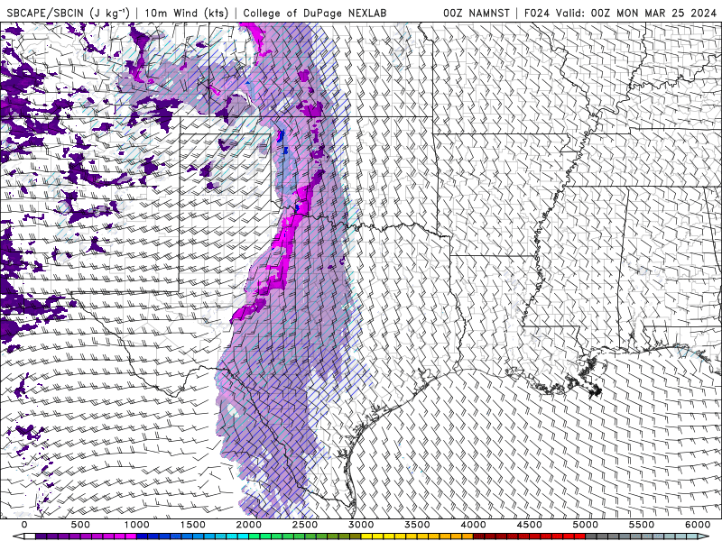
Now a Day 4 15% risk in a similar area. NWS FWD awaits the event moving into the range of the hi-res models. ~40 knots deep shear, which is enough with a forecast near 2500 J/Kg MLCAPE and near 8 C/Kg mid level lapse rates (producing almost 60 TT) but low level shear only about 10 knots probably means not a giant tornado threat. Which is what NWS said. Not good news, we're going to Euless to visit my Mom, 90 years old. May suggest a rental car to my wife. We leave Wednesday, which will be in range of hi-res models.
-
That escalated quickly.
-
On 2/14/2021 at 7:48 PM, Ed, snow and hurricane fan said:
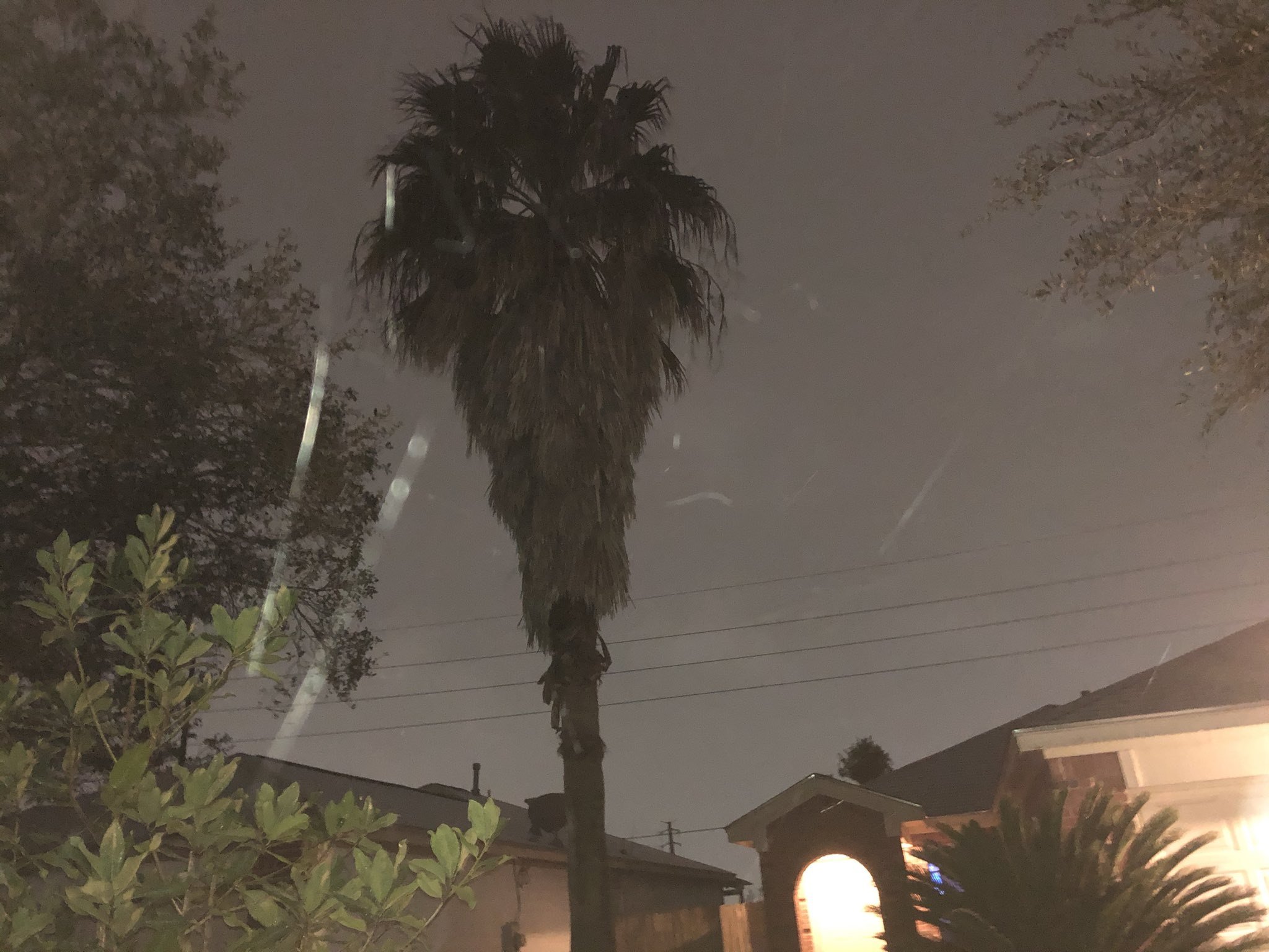
Freezing rain is now snizzle. Not exactly snowflakes, but little frozen white things that are slowly drifting down. Near I-45 and BW8 North side of Houston. Internet says that palm can handle teens and 20 hours below freezing, so it is probably going to die.
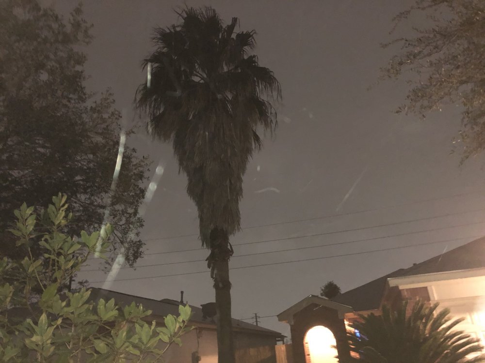
A lot of palms died from the 3 hard freezes in four years, but the big palm, one seedling I transplanted a couple of years ago, and many of the little ones that pop up in the garden like weeds survived this years hard freeze. The banana plants look dead, but they do that every year with a frost and always come back from the roots.
-
2 hours ago, Chargers09 said:
Using a 200+ hour gfs run doesn’t convince me it will happen. What is the gefs showing
GFS and Euro ensembles are singing the same song. Not like I was calling for a snow storm 8 days out.

-
1
-
 1
1
-
 1
1
-
-
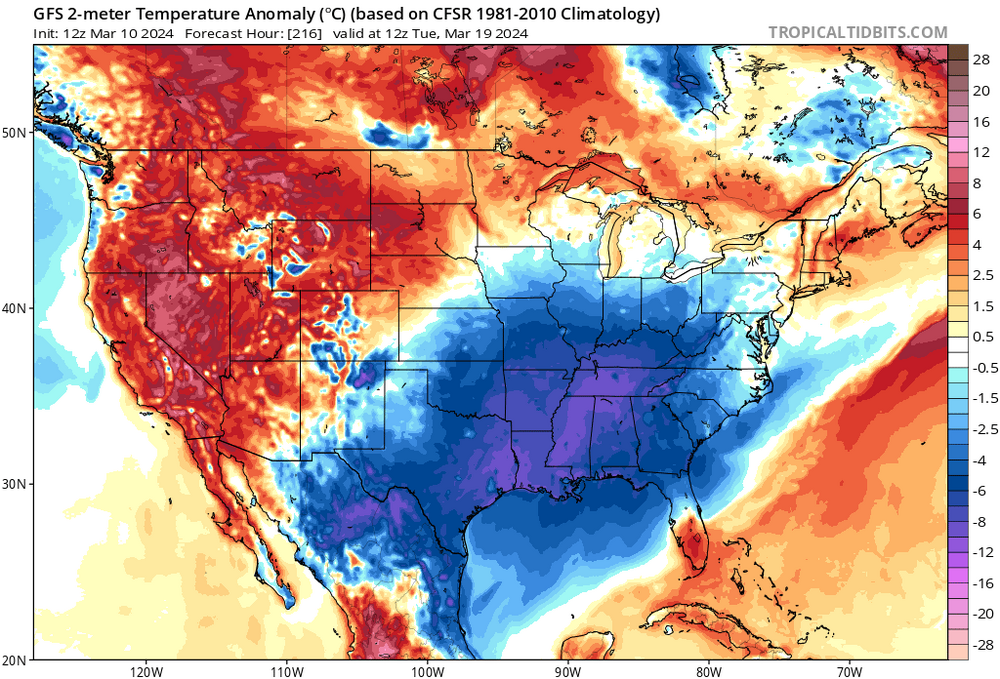
Winter returns in a week. Not cold enough for anything fun, just cold. I'd expect to have warm stretches in March w/ daytime highs AOA 80F, and after this week, I don't see it. May see some severe N of here Thursday and Friday, but I don't see enough warmth for anything after that.
-
1
-
-
1 hour ago, Stx_Thunder said:
12 Z runs yesterday and today on both GFS & Euro are starting to show a forecast trend in less convective CIN in S-SETX (including Houston area), Friday morning ahead of the initial Pacific front/dryline (dry, modest polar reinforcing front Friday night). But even though moisture, and DL shear is looking good (generally 60 kts) on both globals, forecast ML Lapse Rates aren’t (< 7) and seems to be trending lower. CAPE modest also (but sufficient). So that’s likely going to tamper atmospheric instability and severe hail, lightning threat a bit if storms happen. SRH values aren’t great also.
Timing of frontal passage and 700 MB Low track over the TX Panhandle on those 12 Z runs comparison seems to be slowing down a little too. That could allow for a little better dynamics aloft. And instability on Friday in the lower levels and surface if frontal passage is indeed later midday.
Will be interesting to see what CAMs (especially HRRR & ARW-2 as those have been doing the best lately), show when the time period comes into window tomorrow night. But since it is a positive-tilt (but formidable) incoming mid-upper trough being shown, I still wouldn’t be surprised if timing of shortwave energy ends up being somewhat out of sync with frontal passage in SETX. Though that’s usually a bigger problem with fronts further southwest in STX even if environment is favorable for storms. Especially this time of year.

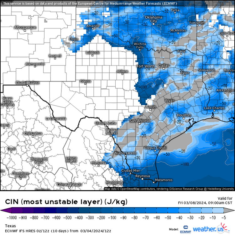
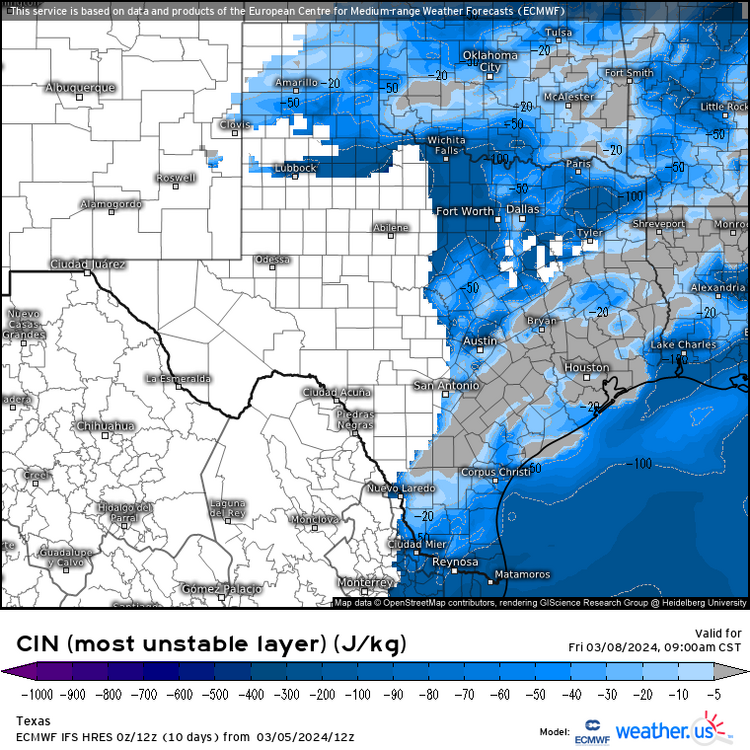
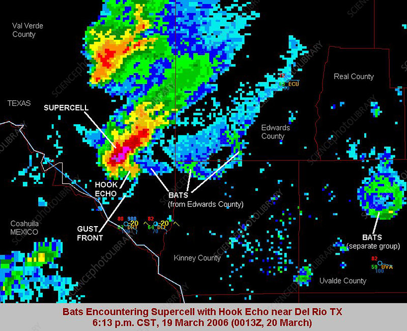
Looking at Euro 24 hour precip Friday, there will be storms that track just N of us. It looks better than the GFS for some needed rainfall but still showing SW flow in the 850-700 mb levels. I fear a dry Spring leading to the feedback that produces another 2 months plus of 100F temps around here. I think Euro's 250 mb RR entrance may be helping overcome a bit of the CINH, it would be nice if that whole thing edges a smidge S for better jet support. In your neck of the woods, I'm waiting for the under forecasted severe storms that form over the mountains in Mexico and drift across the river in the evening. I've seen pictures of big hail and damage from those storms. And there is actually more than 1 image of the net of the bats in the W Hill Country getting ingested into supercells. I found out they live under bridges in Houston as well after the last hard freeze stunned many, living in Austin late 80s/early 90s, I thought the bridge bats were unique to there.
-
12 minutes ago, ma blizzard said:
on the 12z run? I’m not seeing it
Not most recent but 3km NAM shows ice starting to accumulate inland, at end of run.
-
Thoughts on interior ice accumulations? Euro has been suggesting it for several days.
-
1 hour ago, michsnowfreak said:
Thanks for the list! What is the difference between Ensemble & NOAA?
I assume NOAA is just the one US agency, ensemble is the average strength by other US private and international climate observation organizations plus NOAA.
I could be wrong, but it makes sense.
-
 1
1
-
-
MBY not included. Positive tilt systems always mean I-10 area SAT to HOU is always capped.
WE could use the rain here, the drought has ended but it has been a dry 6 weeks. Even into the Gulf Coast Friday, GFS seems to show capping that would be hard to break.
-
-
-
1 hour ago, jm1220 said:
67 in S Nassau around Sunrise Highway.
Just 44 years ago, I'd cross Sunrise Highway and walk under the LIRR tracks to go to the mall. NWS page says 77°F here in Houston, about 7F warmer than normal, but 67 must be closer to 20 above. I miss the snow, I missed 5 straight days of school in 1978. N. Houston suburbs, we actually seem to have more ice storms, two in the last 3 years. 1995, I think it was in college in Austin, 99F, a February record, followed one week later by an ice storm. Ice Houston and Austin can do, I remember a 6 inch 1980s Dallas snow storm with snow on the road for a couple of days, the Panhandle at 3000 to 4000 ft ASL, snow every winter. But Houston, a few frosts most winters (but banana plants down here will bunch if there isn't a winter frost and the above ground part of the plant lives), a hurricane once a decade, two or three times a decade an ice storm or a dusting of snow so that people can't write the date on their windshields and post the pix to social media.


Convective Chronicles- like Levi Cowan, but for tornadoes/severe
in Weather Forecasting and Discussion
Posted
I'm guessing I'm not the first person on the board who started watching the videos, but YouTube somehow knew to suggest Convective Chronicles. Tropical Tidbit style discussions of ongoing events, and 45 minute post-mortems of significant tornado events of the last 30 years. On Twitter/X and YouTube.