

Ed, snow and hurricane fan
-
Posts
2,133 -
Joined
-
Last visited
Content Type
Profiles
Blogs
Forums
American Weather
Media Demo
Store
Gallery
Posts posted by Ed, snow and hurricane fan
-
-
29 minutes ago, WxWatcher007 said:
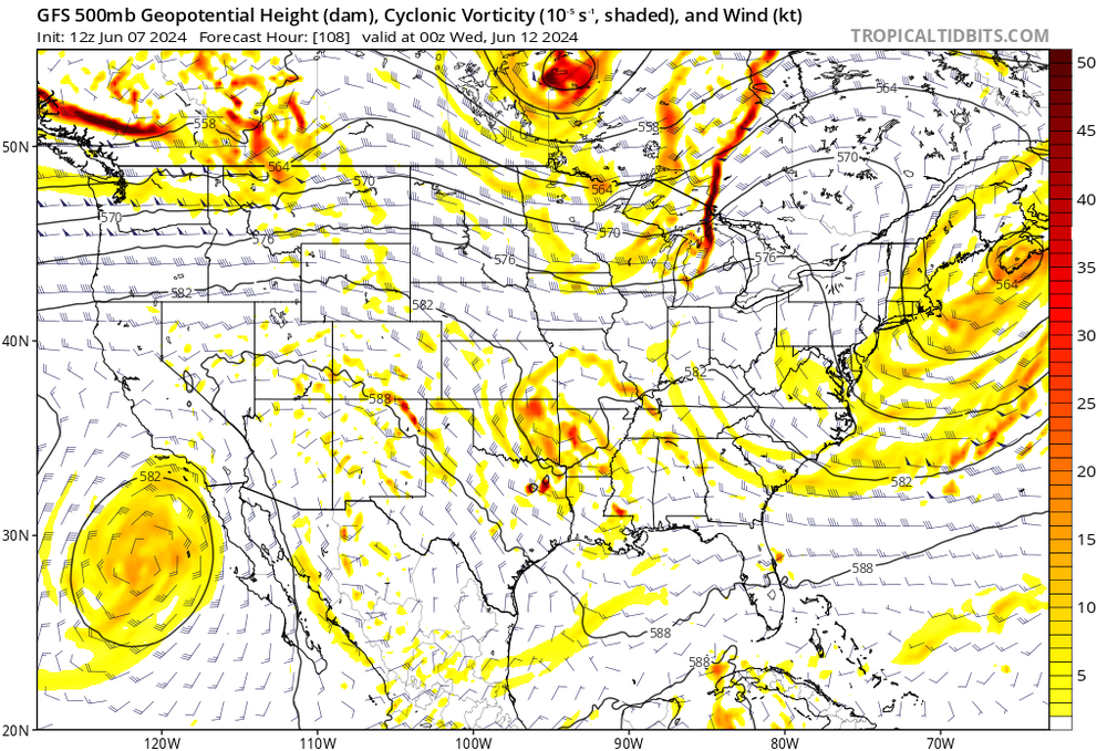
Euro and GFS were back to a more aggressive development signal last night and this morning as well. Shear still looks really tough, but even on the guidance you can see the low organizing some as it heads off NE.
I think 90L overperformed yesterday in spinning up a concise mesolow with persistent but sheared deep convection. It’ll be interesting to see what happens once that broader low level spin leaves FL later. There is plenty of vorticity for something to spin up. Whether it becomes tropical remains to be seen.


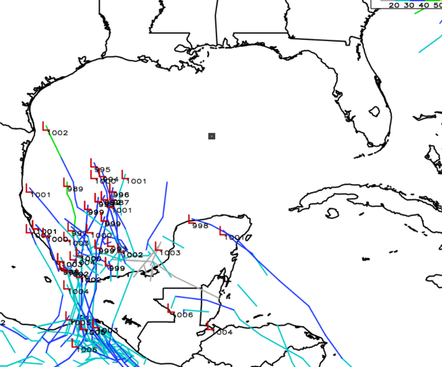
Meanwhile, the Bay of Campeche signal has become stronger as the ensembles try to keep the region in a lower shear environment when development becomes possible in the coming days. That area has a good shot of triggering TC genesis imo, and now has a NHC lemon.


It’s not really there except occasionally on long range op runs, but I still wouldn’t sleep on the third area I highlighted in the western Atlantic ~10-12 days from now either. Euro toyed with that last night again.
If folks are wondering why so much is getting posted…this is a really active signal for June. I’d be surprised if we didn’t get at least 1 NS out of this window.
Just based on the models, the soon to be SEUSA will probably at least get numbered, even if it isn't named. 20% 7 day seems low to me. IMBY, the forecast low down in the BoC is forecast to be more organized, which is reducing model QPF. More rain would delay, and perhaps reduce, the heat range in SETX, which is good, but at a job interview near TX 99 and I-69/US 59, there was standing water on the lawns, so missing out on what had been forecast to be between 1-2 inches per day for 3 days, with 4 inch totals, wouldn't be a bad thing. Standing water is a recipe for mosquitoes. And tadpoles, when I worked in Houston, a puddle had tadpoles in it, which fit in wonderfully in discussing biotic and abiotic parts of an ecosystem which we were learning. Did the tadpoles make it to the toad stage before the puddle dried, I'm not sure.
6Z Euro ensembles weaken the ridge from prior runs, I could see the system which now has a lot of model support, making it as far N as the Rio Bravo del Norte (Spanish for Rio Grande), Dolly in 2008 rained on Houston with a landfall on the border. cc: @Stx_Thunder

-
17 minutes ago, olafminesaw said:
3.93" in the last hour

The cloud top temperatures with the convection have been as cold
as -70 to -75C, and with a highly tropical environment with PWs
pushing 2.25+ inches, some of the rainfall rates have been
reaching 3 to 4 inches/hour over the last hour. Part of the
convective band is offshore, but part of it over the last hour has
edged onshore and is impacting the urban corridor from near
Bradenton southward down through Sarasota.

Recent radar trends suggest some northward advance of the
convective band with the low center also showing some evidence of
deepening somewhat which suggests the ongoing convective
organization, albeit it sheared, over the southeast part of the
low center may maintain itself in response to stronger low-level
convergence/forcing.

This suggests at least in the near-term that extremely heavy
rainfall rates within this convective band may continue to edge
farther inland and persist, with impacts in particular along the
Bradenton to Sarosota urban corridor.

Given extremely high rainfall rates of 3 to 4 inches/hour, some
storm totals over the next 2 to 3 hours may locally approach or
exceed 6 to 8 inches. Urban flash flooding is considered likely
given the set-up, and this situation will need to be closely
monitored going into the evening hours.

Orrison
https://www.wpc.ncep.noaa.gov/metwatch/metwatch_mpd_multi.php?md=0425&yr=2024
-
 2
2
-
 1
1
-
-
23 minutes ago, BYG Jacob said:
Africa Standing Wave likely to take hold through July soon.
This would suggest if nothing happens in the next week or 10 days, nothing will happen for the next 6 weeks. At least the old climatology, June and July combined produced just more than 1 TC, or a sedate Atlantic for the second half of June and July would be normal.
-
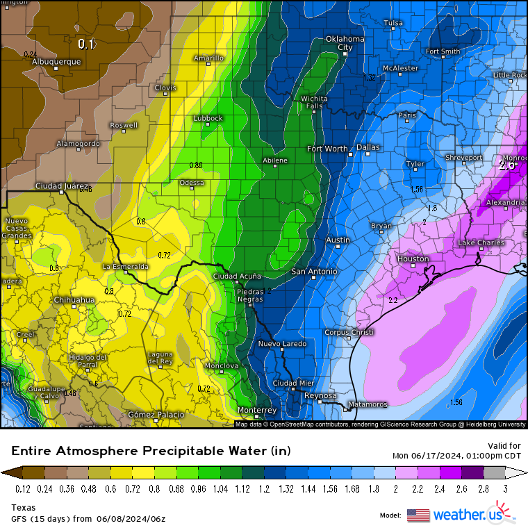
GFS and ensembles suggest frequent showers this time next week from a weak but broad area of lower pressure deep in the BoC that pumps in high PWs into STX, over 2.5 in Houston, and close to 2.7 inches in Alice, the town I consider the center of South Texas. I had a friend who finished college before me who lived there, I visited several times, had a brief relationship with my friend's GF's sister, and saw a real John Wayne movie style bar fight, started with 2 women, then their boyfriends jumped in, and then the whole bar. I stood with my back to a corner so I wouldn't take a beer bottle to the head from behind.
Anyway, I am of the belief that a heat ridge delayed is a heat ridge weakened, delayed and with wet ground, doesn't get as strong due to feedback from hot and dry ground. The daily rainfall in this scenario of 1 to 2 inches per day wouldn't cause flooding. Globals differ in detail, but all show elevated PW
-
 1
1
-
-
I'm still thinking a closed low develops off SEUSA from the vorticity just W of TPA. It'll be an E weighted system, it may never get beyond a TD or whatever they would call an STD if that abbreviation wasn't more widely know for something else. Might still be Alberto. IMBY, the op GFS and ensembles with a weak and broad low buried in the BoC but swinging deep moisture towards my house, with PW off 2.5" or higher this time next week, I like that. It has been a fairly wet spring, with an unusual amount of severe weather in SETX, but I think damper ground helps limit the feed back of the inevitable Mexican heat Ridge, and helps avoid the repeat of Summer 2023 here.


-
1 hour ago, jlauderdal said:7 hours ago, Ed, snow and hurricane fan said:Euro and Canadian ensembles don't support the GFS and ensembles very low NW Caribbean/Gulf pressure at 2 weeks at all, but the entertainment value of what are likely spurious storms is high.
Back in the real world the rain from the moisture pooling in the NW Caribbean and Gulf isn't a bad thing, the heaviest rain looks to fall in S. Florida which is in level 2 (severe) drought.
We can easily handle a foot of rain over 5 days, problem is training on the SW coast and you get to 15 inches in less than a day. We had an event in Fort Lauderdale a year ago, 20+ in 12 hours but very isolated, this setup is very different. Lots of noise in the models, gulf really isnt favorable for at least a week, maybe something finds a small window but its all about the rain for this one and the texas system down the road,maybe.
I'm 50/50 on Alberto developing off SEUSA and then OTS. Anything after seems quite uncertain. Two weenie GFS runs in a row, but when has the GFS been right 2 weeks out?
-
Euro and Canadian ensembles don't support the GFS and ensembles very low NW Caribbean/Gulf pressure at 2 weeks at all, but the entertainment value of what are likely spurious storms is high.
Back in the real world the rain from the moisture pooling in the NW Caribbean and Gulf isn't a bad thing, the heaviest rain looks to fall in S. Florida which is in level 2 (severe) drought.
-
1
-
-
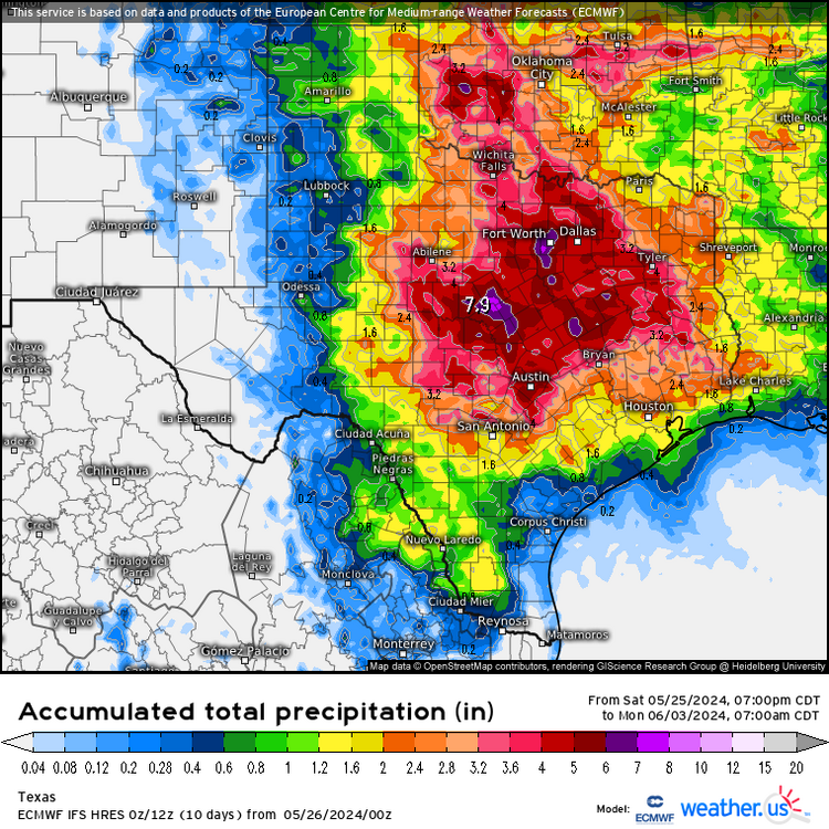
Light and variable winds (except in t-storms near Corpus Christi) and RAP PW of 1.7 inch or higher (AOA 2 inches from Matagorda Bay down to Mexico) is probably supporting the weakening MCS moving offshore near CRP and the sea/bay breeze storms forming just inland further N. Not sure where the front is exactly, but it is probably also helping. There is also a broad mid-level low over NM/TX Panhandle which per 12Z NAM will be ejecting random bits of vorticity. Now that the floods have gone down. the longer the occasional rain kicks in before the summer heat ridge builds in, the better. May keep the ridge a bit weaker with evaporational cooling of damp grounds. May make for an overall milder summer. Euro/American and Canadian ensembles all show the ridge centered out in New Mexico and Arizona in 2 weeks, which may keep us from the two months of 100F or higher temps in STX of 2023.
-
-
1
-
-
9 minutes ago, Stx_Thunder said:
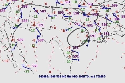
Saw towering cumulus (convergence bands) early this morning moving onshore around here. So subsidence from H5 furnace High over the state now is not strong (despite lack of moisture aloft currently over the coastal region). H5 heights are just barely above 590dm around here.Pretty weak for STX standards.
- - - - -
Both Euro and GFS showing a fairly deep northerly M-UL flow & some notable DL shear over the state for this time of year, this upcoming week on the northeastern periphery of High moving further west-southwest again back over Mex. And, the cutoff H5 Low sitting just west of Baja.

- - - - -That should cause some decent ML shortwave energy from that Low to curve east around the northern side of the High and then southeast - southward, deep into the state as the High is still projected to be pretty weak/small (still just around 590dm center) on GFS today. Which I wouldn’t doubt, all things considered lately. Euro this morning is a little more bias.
Overall so far, a sig turnaround compared to June last year in 2023 when the furnace High really grew & strengthened like hell on earth by mid-month. Also, still not seeing a real strong signal on the furnace High really taking over either on ensembles the next couple of weeks. GEFS and EPS are actually starting to trend upward on Total QPF at the end of cycles over the Eastern half of state on latest runs.
- - -
‘Will see how July goes with the furnace High (which normally starts to take over more by then). But I’m basically calling this a “make-up” summer for 2024 now, as we also got a meandering H5 Low or wave starting to show up just east of the coastal region & some 2+ in. PWs moving over the coast (more so over SETX) on both models, Fathers Day weekend into following week.
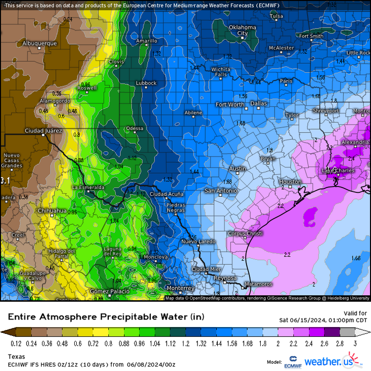
Just a look at the US and Canadian ensembles, NTX is getting the most rain. Canadian OP shows little rain near/S of I-10. Sort of OT, but South Florida looks rather wet on those ensembles, with the op runs of both suggesting near/more than 1 foot next week. I suspect IMBY, any rain will come on the afternoon sea and bay breezes, although an MCS surviving from the DFW area isn't a non-zero. possibility, as they say. Early Euro suggests a bit of the trough to the E of us may pinch off and move W, that scenario would seem favorable for enhanced afternoon storms along the TX coast.
-
Heat ridge still stubbornly refusing to lock in. Another NW flow event next week on all the ensembles. Tuesday afternoon & evening looks like another round of severe weather for NTX if GFS is any guide..
-
I suspect it is a product of the heat sink element of the Carnot engine (a simple way to describe the operation of a hurricane or a steam turbine power plant) becoming warmer as well, but Instability/potential intensity is not rising in line with the record warm SSTs. Perhaps an indicator the seasonal numbers won't be as extreme as some suggest. OT- Twitter posts used to actually appear embedded in the AmEx post. Something changes.
https://x.com/DrKimWood/status/1798745800031523106
-
The GFS is developing things late next week/following weekend, but the GFS has a bias and develops too many TCs. But some of the 0Z Euro ensembles are starting to show something as well. I think based on SSTs in the neighboring basins, a Pacific system is favored, but not guaranteed.


-
1
-
1
-
-
You don't see an Oklahoma style wedge in Maryland very often.
https://x.com/weathertrackus/status/1798504625047560500
-
Active tornado warnings for radar indicated rotation with the QLCS moving through the Florida parishes (N of New Orleans in E Louisiana. The same QLCS has several severe warnings in LA/MS
-
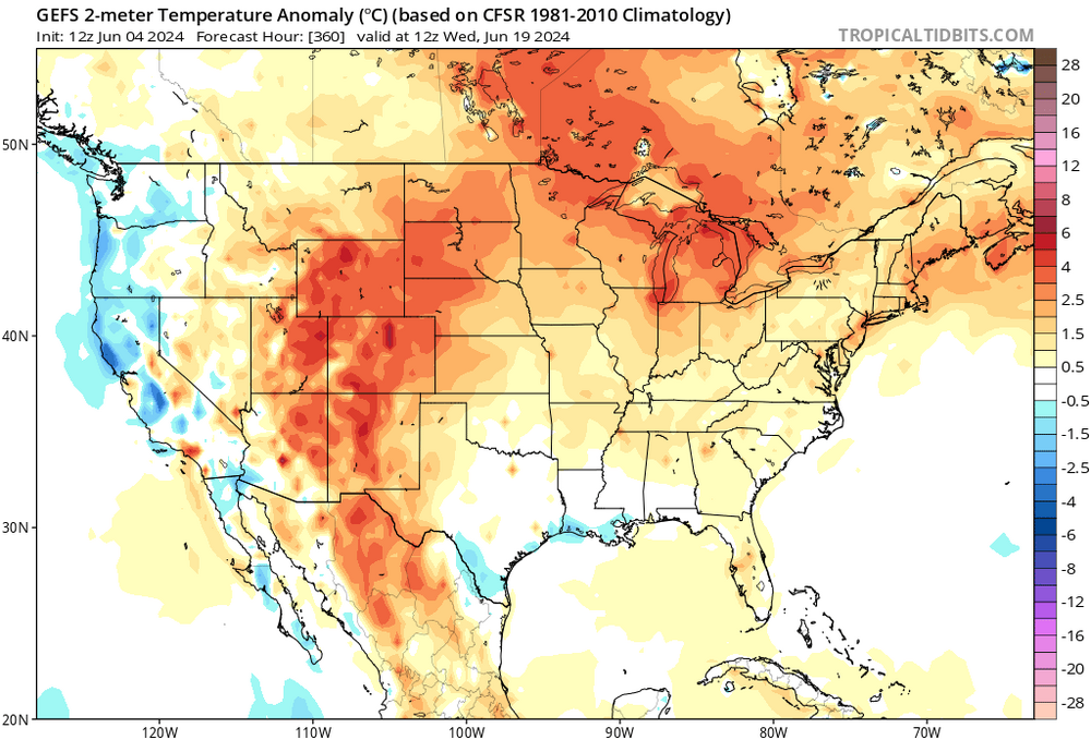
Looks like the ridge runners are slowly moving N and E as the Mexican heat ridge builds in. Highest heights look to be in Chihuahua, and all the ensembles at 360 hours show normal or even slightly below normal temps for much of the E half of the state.
-
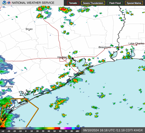
Severe T-Storm Watch for the coastal plain/US 59 corridor from just N of CRP into most of the HOU metro. Storms are building and slowly moving NE into the HOU, but none are warned or look particularly strong.
There is a lonely but strong cell with radar indicated hail approaching DFW.
-
There was still random CG and pockets of heavier rain at 10 am. I'm surprised there was even an MCS today with last evenings storms. STX looks undisturbed, and I see an outflow boundary. And low clouds burning off.
-
1
-
-
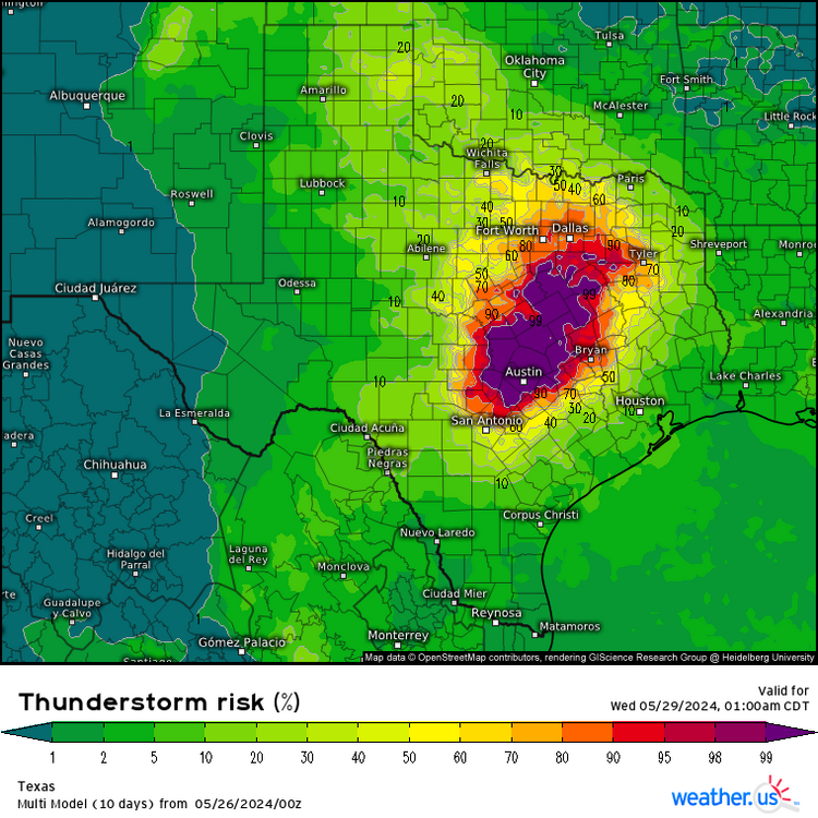
SPC going enhanced for Central Texas. 3 kn NAM forecast soundings on I-35 in Williamson County at 6 pm shows 'meh' shear, but 4000 J/Kg MLCAPE and 1400 DCAPE. SPC also extended SLIGHT to NW Houston suburbs, not mentioning cold pool propagation directly but stating storms in this situation frequently move faster/further than modeled. EDIT TO ADD: this time last week ensembles suggested that spring was over south of US 84.
-
18 hours ago, beavis1729 said:
Falfurrias TX was 101/82/128 this afternoon.
That borders on the insane. Not the heat, the dewpoint with that kind of heat.
-
57 minutes ago, Witness Protection Program said:
Video from inside the Sanger gas station (I-35 & Lone Oak Road) when the tornado hit
https://x.com/ConnerStinesWx/status/1794804153551900895
From other video today over a rural subdivision 2 miles to the west (Lone Oak Road at 200 road) the heavy damage of houses is at least a half a mile wide
https://x.com/foxweather/status/1794761278809883096
(:48+)
Watched the Ryan Hall YouTube channel, he as Google maps or similar, to the street view, and there are probably few places with a greater concentration of RV parks than around Lake Ray Roberts. For a beginning of summer holiday weekend, the death toll could have been even higher. Two large damaging tornadoes simultaneously, when there were few other storms at all in Texas or Oklahoma, was bad luck. I suspect the fact that the storms were very isolated in favorable instability and shear probably boosted both tornadoes.
-
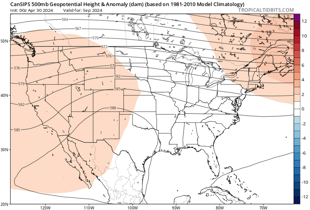
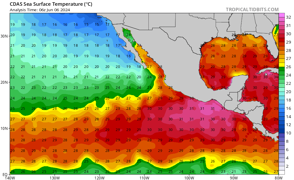
Super premature, but the September CanSips 500 mb heights looks downright scary, in a season with possible 10 or more hurricanes, for the Central and Eastern Gulf. Had to check, 42035 at 85F, averaging about 82F diurnally the last couple of days, is warm for so early, but if CanSips is right, MBY is in good shape.
Being 60, fat, and on a CPAP, Ike was an adventure, any hurricane now would be an uncomfortable drudgery.
-
 1
1
-
-
Wouldn't RONI minimize the upcoming cool ENSO because of the warming Atlantic. I know that is the opposite of what it is supposed to do, I can see how it works with a warm ENSO, but not a cool one.
-
6 hours ago, Stx_Thunder said:
Both GFS & Euro been showing stronger and stronger signs of the furnace 500mb High weakening & moving further southwest away from the state a bit this upcoming week (could stay that way into at least the first week of June also which could increase flooding potential again in NTX/ETX as both models also trending upward on rainfall totals into beginning of June).
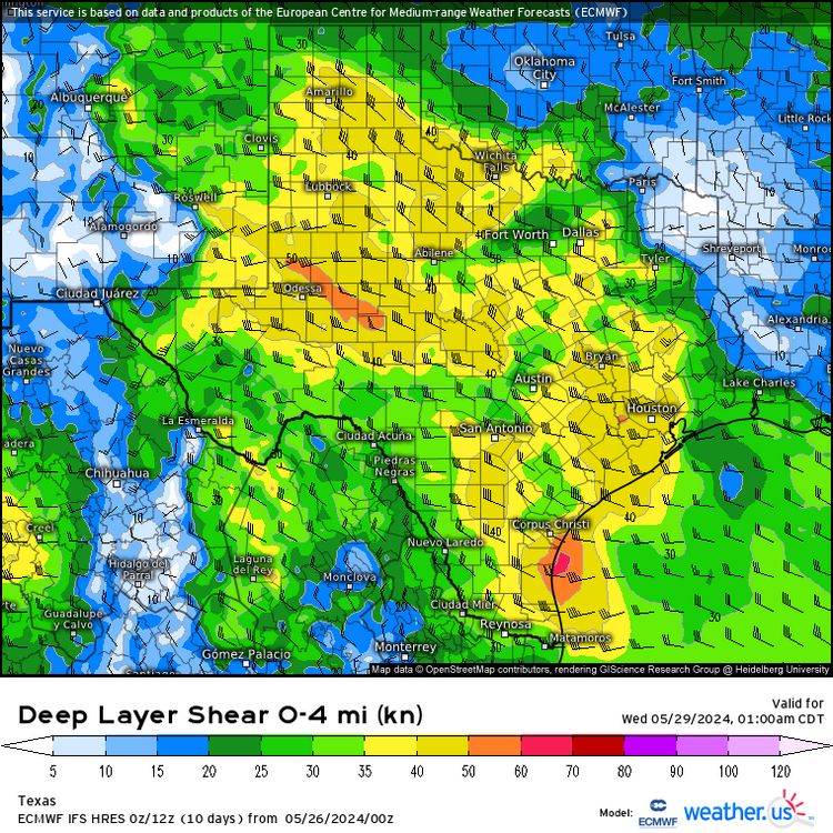
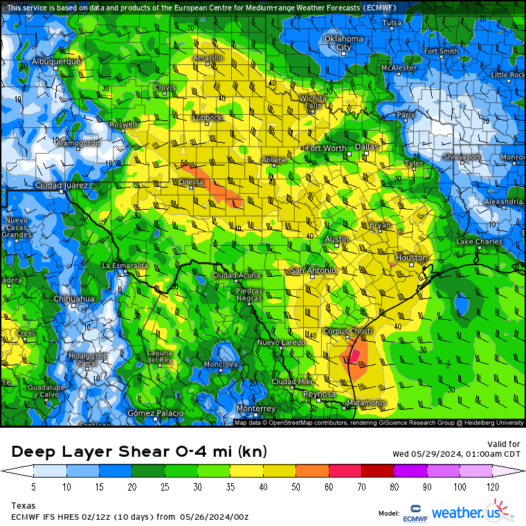
It’s definitely looking more convectively interesting with likely, better or bigger MCS activity propagating farther south (including into STX with some heavy rainfall with 2+ in. PW projections which is easily achievable by this time of year), starting later on Memorial Day. But particularly Tuesday - Wednesday and late this week/end, as there’s very notably steep ML lapse rates, along with DL shear 40 - 50 kts projected over a good amount of the state.
Both still abnormally high in late May now.
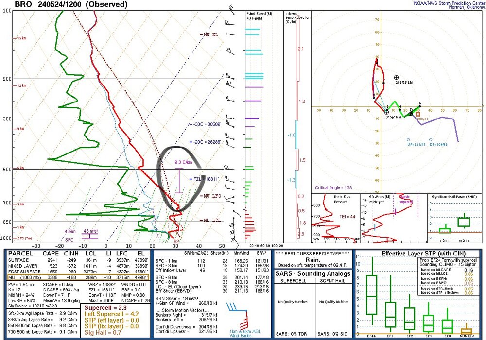
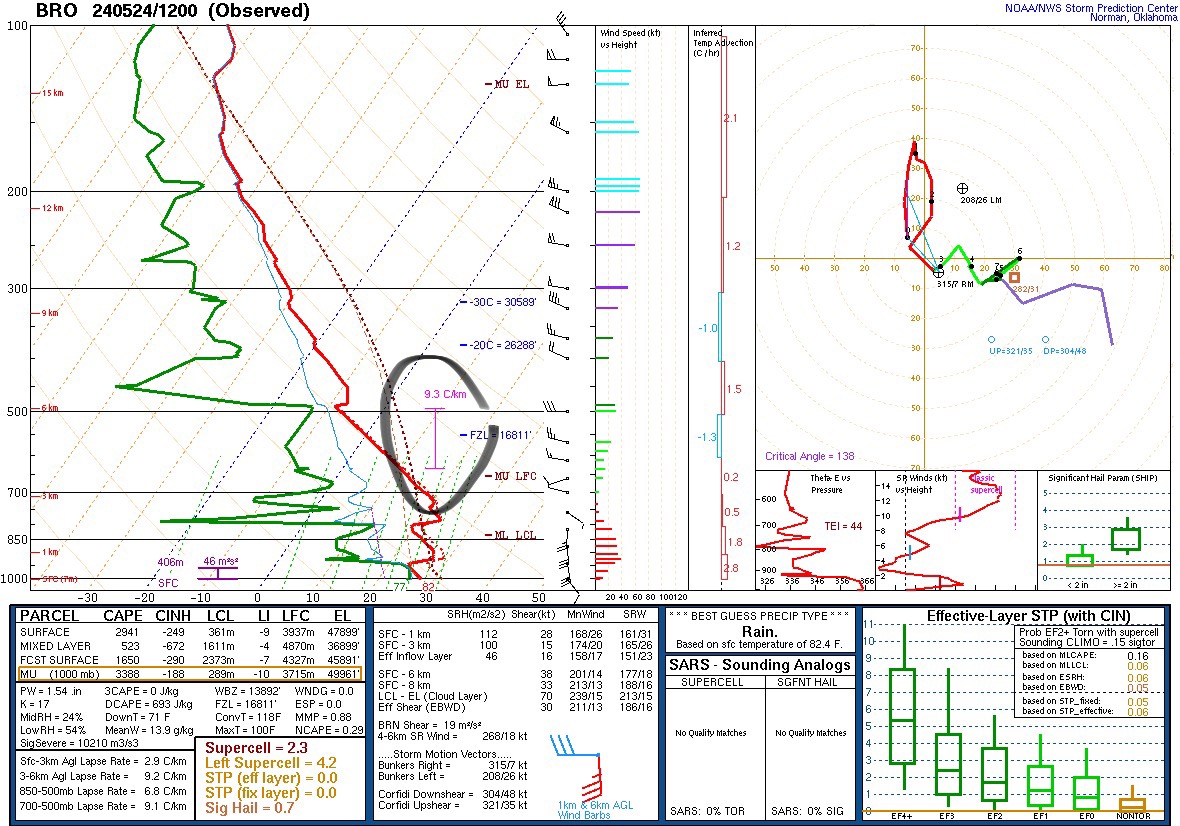
- Saw ML lapse rates on Brownsville 12z sounding two mornings ago on Friday, of 9+ C/km.Definitely steeper than normal down here in late May (even 8 too). No doubt about that.
You may want to keep in mind that South TX can actually get upstream MCS activity typically through about mid June. Especially with SS flow influence still in place in the mid-upper levels (as has been the case many years during past 2 decades).It may be officially summer at the surface around here (that’s always typical by later May in STX). But that isn’t normally the case aloft most years until the latter part of June.
Was not convinced last weekend on EPS H5 height projections for the end of May as it was wobbling around on runs and going as high as almost 600 dm. Which just isn’t plausible so early in the hot season. Even in STX. Especially with EN influence basically gone now. GEFS was more consistent, and SPC daily observed UA 500mb data down here during this past week has been much more closely reflecting GEFS H5 height prediction from last week (staying around 590dm which is pretty close to normal in STX).I’m very convinced now we’re not going to have the kind of hot/dry persistence of Summer 2023. At least around the coastal region. With LN creeping back, there’ll likely be some more tropical activity also later this summer. But doesn’t translate to a hurricane for TX coast this year. Especially coming off a very formidable EN phase just this past winter - spring. That’s never happened before on climate history the past couple decades.
I suspect if we get >20 NS in the Atlantic, Texas probably will get a storm. Beta and Imelda were nothing burgers, but both caused some significant flooding in SETX. I do suspect the ridge will be strong enough to keep any storm forming or entering in the Caribbean down in the Caribbean or Campeche. But, as I said, >20 NS, hard to imagine Texas escapes w/o at least a TS.
The 500 mb Euro ensembles were bullish on summer locking in about a week ago...


2024 Atlantic Hurricane Season
in Tropical Headquarters
Posted
I assume it is a resolution issue w/ the UKMET, the model can't see winds of 50 knots w/ low 980s pressure. A chart of dropsonde pressure and max wind in the Atlantic Basin (one was in the Gulf) from Brown, Franklin and Landsea 2006 analyzing recon data from 1998 to 2005 (they note the abundance of data from 2005) suggests in the Gulf, 980 mb would have, on average, about 77.7 knots max winds. They found little difference in the correlation between sub-basins in the Atlantic, there was a difference at higher latitudes. There is wider difference from the empirical best fit South of 25N: Vm= 10.205(1014.4-p) 0.5736 to the experimental data when pressures are lower and winds higher there is a greater spread from the recon data to the predicted value. Lower wind/pressure, ie, ~75 knots and 980 mb) would have a P/W relationship pressure with a smaller difference from predicted wind based on pressure and the max/min winds recorded by recon.
I do realize at higher latitudes with the wind field increasing and max winds decreasing, 77.7 knots would be too high a value I suspect there aren't that many recon missions with GPS dropsondes above 40 degrees N to develop a relationship. (I couldn't find anything on Google Scholar, but I don't have the experience wording searches as compared to Google But I'd still think the UK winds for the pressures is low. High latitude relation of North of 25N: Vm= 8.636(1015-p) 0.5989 is given, Desmos says that is 73 knots. >40 degrees may not work for a relationship for storms >25N