Danny8
-
Posts
54 -
Joined
-
Last visited
Content Type
Profiles
Blogs
Forums
American Weather
Media Demo
Store
Gallery
Everything posted by Danny8
-
25th anniversary of a record low of 49 on July 2, 2001. That is the last time a daily record low minimum was set in July. Every other month has set a daily record low minimum since then, but that was the most recent one in July. (October’s most recent was also set in 2001). https://www.weather.gov/lot/chicago_climate_records
-
I think that a lot of the frustration comes from saying that April (7th warmest on record in Detroit and Chicago) is equivalent to any of these months being below average, when none of them were anywhere near 7th coldest. Essentially the argument you guys are saying is 7th warmest is balanced by being colder than normal, even if it’s like the 50th coldest (I didn’t verify the actual ranking, feel free to check what those below average months ranked). So it just feels like a false equivalency that you guys are arguing.
-
Just saw your post but I had been thinking the same thing all day! Planes definitely sounded different to me as well. I’m about 10 miles east of ORD
-
1/24-1/25 Major Winter Storm - S. IL, IN, and OH
Danny8 replied to A-L-E-K's topic in Lakes/Ohio Valley
Im heading to family in Detroit area tomorrow morning for the week, hoping to get in some good cross country skiing. However like Beavis I was also out for a walk just to feel the -9 in Chicago this morning lol -
-
@A-L-E-Kmade a comment awhile ago about this being the greenest drought he remembers and I definitely concur for my neck of the woods. For some reason im in moderate drought on the monitor but haven’t watered anything the entire season and the yard is all green
-
Yeah since June 20th or so we’ve had only a few breaks from the humidity. Hopefully it reverts to the mean with a below normal humidity August but it probably won’t
-
It has been quite humid and uncomfortable in my option. But I’m a couple miles off the lake. Have only had a couple days I could have the windows open since June 20th
-
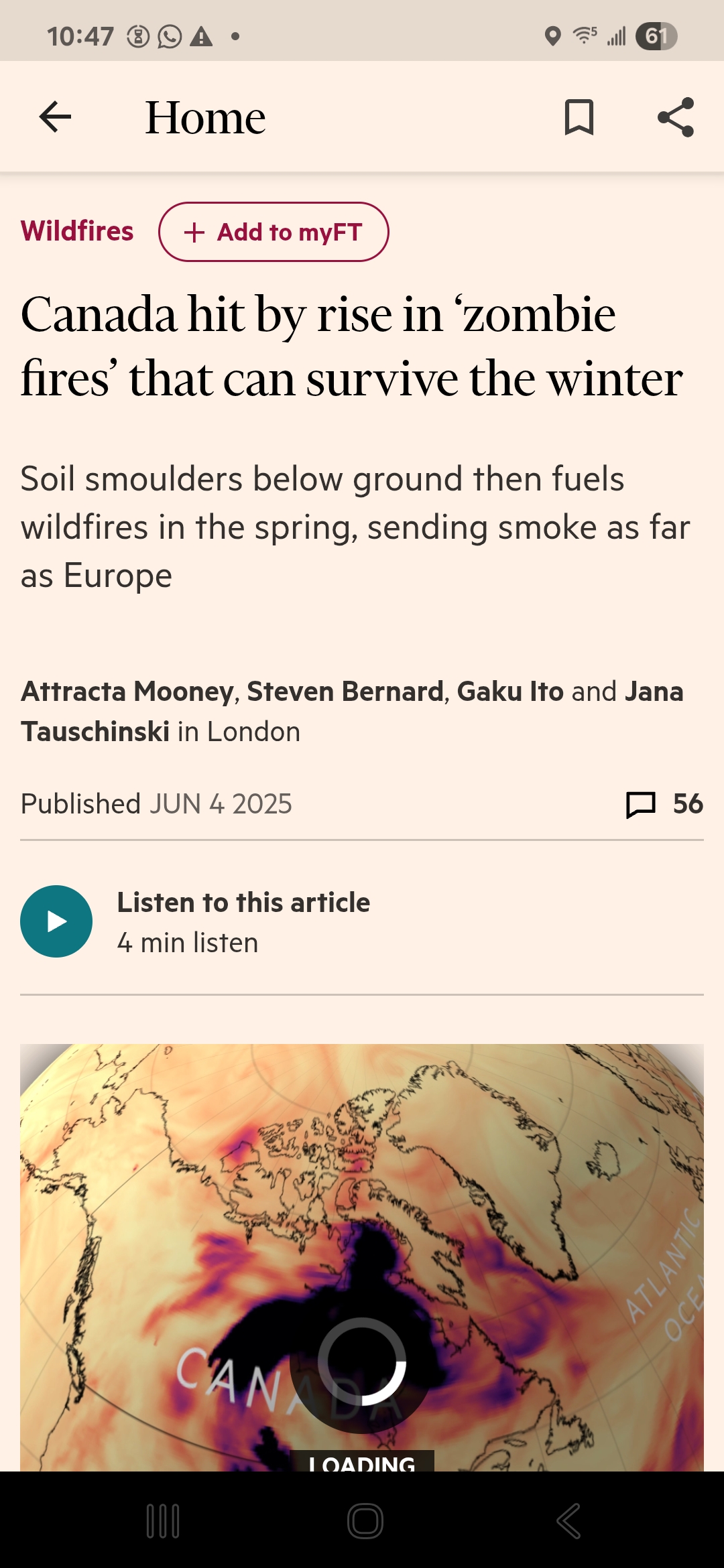
Actually… it apparently was Zombies! https://www.ft.com/content/f87c4c4f-41de-4951-9bdf-286da55aac0f
-
Unfortunately doesn’t detail specific locations but gives that idea

-
Go to the NWS Chicago site (https://www.weather.gov/lot/). Click on "Climate and Past Weather", and you can search those things in the NowData tab. Select the "Monthly summarized data" product. Monthly Mean Max Temperature for CHICAGO OHARE INTL AP, IL Click column heading to sort ascending, click again to sort descending. Year Jan Feb Mar Apr May Jun Jul Aug Sep Oct Nov Dec Annual Mean 31.6 35.9 47.2 59.0 70.3 80.4 84.3 82.6 76.0 63.0 48.7 36.8 59.6 1995 30.3 33.9 49.2 54.6 68.7 83.7 88.0 87.7 73.5 63.0 40.9 33.6 58.9 1996 31.3 33.9 40.2 55.4 64.4 78.0 80.1 82.1 73.3 62.2 39.8 33.5 56.2 1997 27.8 35.1 46.2 55.5 63.9 79.3 83.1 78.2 74.2 63.8 42.5 36.1 57.1 1998 35.3 45.0 45.6 58.7 75.4 79.5 84.1 82.5 78.3 64.3 52.4 42.7 62.0 1999 29.9 42.1 44.4 58.4 72.4 80.4 88.3 79.3 75.7 63.7 55.6 37.7 60.7 2000 32.1 42.2 54.6 57.6 72.1 76.8 79.8 81.8 74.6 66.1 43.8 24.4 58.8 2001 30.8 34.0 42.7 64.2 70.2 77.5 85.0 81.7 71.0 60.3 57.4 40.2 59.6 2002 38.5 40.2 43.6 58.9 65.2 81.1 86.6 82.8 78.9 57.5 44.8 36.9 59.6 2003 28.3 32.3 46.5 58.7 66.0 76.7 82.9 82.8 73.7 62.4 49.5 38.6 58.2 2004 27.4 35.8 49.3 61.4 70.9 77.3 80.5 77.0 78.4 63.0 50.3 35.8 58.9 2005 31.2 38.9 43.9 63.4 67.8 85.2 86.4 84.0 80.1 64.3 51.4 29.4 60.5 2006 42.0 36.3 46.7 64.1 69.7 78.8 85.7 83.0 71.1 57.5 50.2 40.5 60.5 2007 33.8 24.4 51.3 56.5 75.5 81.6 83.5 83.2 79.2 68.1 47.0 34.1 59.9 2008 32.0 29.7 42.5 59.8 66.2 80.9 83.8 81.8 75.2 61.6 46.3 31.5 57.6 2009 23.9 36.9 48.7 57.0 70.6 77.0 78.4 79.1 74.3 55.2 53.1 32.3 57.2 2010 27.4 32.3 50.4 65.5 71.2 80.2 87.1 85.7 74.2 66.8 50.8 29.0 60.0 2011 26.7 32.7 43.8 56.1 67.8 79.4 88.5 82.5 69.9 65.2 52.4 41.8 58.9 2012 38.5 40.2 63.3 59.8 76.5 85.5 91.5 84.0 74.5 60.5 49.0 42.5 63.8 2013 35.3 33.1 39.6 56.3 71.2 78.2 81.8 82.7 77.1 62.4 45.3 31.1 57.8 2014 24.6 25.7 40.9 59.2 71.0 81.0 79.8 82.1 73.7 60.6 41.4 36.9 56.4 2015 29.0 23.4 44.4 60.0 70.0 76.9 81.9 80.9 78.1 63.2 53.7 44.5 58.8 2016 31.7 37.2 51.5 57.4 70.1 81.9 84.4 84.3 77.7 65.8 55.3 31.1 60.7 2017 34.6 47.7 47.1 63.8 67.7 83.3 83.8 80.7 79.7 65.5 46.9 34.2 61.3 2018 31.9 38.0 44.7 50.0 76.4 80.4 85.1 84.8 77.5 60.7 39.7 39.7 59.1 2019 27.5 34.0 42.7 59.1 67.5 77.3 86.1 81.5 76.9 58.7 41.6 41.3 57.9 2020 35.8 37.3 50.9 58.0 69.1 84.0 88.3 86.4 74.6 60.9 55.7 39.3 61.7 2021 33.9 27.4 53.3 61.3 69.7 83.8 82.3 86.2 79.8 66.6 48.2 45.8 61.5 2022 28.6 35.3 49.1 55.1 72.2 82.6 83.5 83.0 76.0 63.9 51.7 35.7 59.7 2023 37.5 42.2 46.0 62.2 73.8 81.4 84.6 83.0 77.7 64.7 51.0 44.2 62.4 2024 30.7 49.2 52.9 61.6 75.2 83.6 83.8 83.8 80.3 70.1 52.3 38.4 63.5 Monthly Mean Min Temperature for CHICAGO OHARE INTL AP, IL Click column heading to sort ascending, click again to sort descending. Year Jan Feb Mar Apr May Jun Jul Aug Sep Oct Nov Dec Annual Mean 18.0 20.5 30.1 39.3 49.9 60.1 65.4 64.5 56.6 44.9 33.2 23.4 42.2 1995 17.7 19.0 31.2 37.4 48.8 60.9 67.2 70.3 51.5 44.4 24.6 19.0 41.0 1996 15.4 18.2 21.3 34.9 45.6 57.9 59.6 62.4 53.6 41.6 26.9 21.9 38.3 1997 10.8 22.8 29.5 34.9 43.6 57.3 63.3 60.8 54.1 42.5 30.2 26.8 39.7 1998 23.8 32.4 32.3 40.8 54.1 59.0 64.8 64.4 57.1 46.6 37.2 26.6 44.9 1999 15.3 25.9 26.8 40.8 50.9 60.3 68.4 61.3 51.1 42.0 34.5 22.0 41.6 2000 18.5 25.9 33.7 36.8 51.9 57.7 62.3 63.0 54.8 46.0 30.2 7.6 40.7 2001 18.3 18.2 25.6 40.7 49.8 57.3 64.1 64.7 52.8 43.9 39.0 26.5 41.7 2002 25.3 24.1 25.5 40.9 45.2 60.8 67.5 63.5 55.8 42.0 30.4 23.4 42.0 2003 14.3 14.9 26.9 37.9 46.5 54.2 61.8 64.4 53.0 41.2 34.2 24.6 39.5 2004 13.2 18.9 33.0 39.3 49.1 56.9 61.9 58.0 54.6 44.8 37.1 21.9 40.7 2005 17.8 26.0 26.2 39.7 46.4 63.1 64.7 64.5 58.7 46.0 32.6 17.3 41.9 2006 29.6 20.0 29.9 42.1 49.5 57.8 67.3 65.6 53.7 40.4 35.5 27.1 43.2 2007 21.9 11.5 33.6 37.0 52.0 61.1 63.9 66.4 57.0 49.9 31.7 21.6 42.3 2008 14.9 16.4 27.2 39.1 44.8 60.7 64.2 63.6 57.1 43.7 32.2 14.2 39.8 2009 7.8 19.6 30.5 37.5 49.1 58.1 60.4 61.8 56.4 42.5 37.6 20.6 40.2 2010 16.5 21.1 33.0 43.6 52.2 62.2 68.2 67.7 56.1 45.2 32.2 16.0 42.8 2011 14.5 19.6 28.8 39.3 48.0 59.5 69.5 64.4 54.4 44.6 37.4 28.6 42.4 2012 21.9 25.6 43.6 41.6 54.6 62.4 70.6 62.6 53.7 42.4 32.0 29.7 45.1 2013 17.9 19.1 25.6 37.5 50.7 58.9 64.5 63.3 57.3 43.8 29.6 15.6 40.3 2014 6.7 8.9 22.4 37.9 49.7 60.9 60.9 65.3 54.2 43.4 25.8 27.1 38.6 2015 15.5 5.7 26.3 38.8 50.7 57.8 62.7 62.6 59.8 46.2 35.5 33.5 41.3 2016 17.6 23.5 35.1 38.1 49.4 61.2 66.5 67.4 61.4 47.9 38.3 18.9 43.8 2017 23.0 28.4 31.8 43.7 48.0 61.6 65.5 62.2 59.1 49.7 32.5 20.1 43.8 2018 17.4 19.6 29.1 32.4 55.9 62.6 67.4 67.7 60.4 44.7 29.4 26.7 42.8 2019 14.5 17.8 25.9 40.3 48.5 58.2 68.2 64.3 61.9 43.1 27.9 26.6 41.4 2020 24.4 23.1 34.7 38.7 50.7 63.9 70.2 67.2 57.9 42.1 39.0 26.4 44.9 2021 24.4 13.0 35.2 42.5 50.8 64.8 66.5 68.1 60.7 52.7 32.5 30.2 45.1 2022 12.6 19.5 32.4 38.9 55.2 61.9 67.0 65.7 58.8 44.2 35.1 22.5 42.8 2023 27.1 25.5 31.6 41.3 51.0 60.2 66.7 65.5 61.2 49.4 34.7 33.8 45.7 2024 21.8 29.7 35.1 43.8 54.5 64.3 66.2 65.9 60.9 49.3 40.0 25.7 46.4 Monthly Total Snowfall for CHICAGO OHARE INTL AP, IL Click column heading to sort ascending, click again to sort descending. Year Jul Aug Sep Oct Nov Dec Jan Feb Mar Apr May Jun Season Mean T T T 0.2 1.9 7.4 12.5 10.0 4.6 1.2 T T 38.5 1994-1995 0.0 0.0 0.0 0.0 T 7.0 13.1 0.4 3.5 0.1 0.0 0.0 24.1 1995-1996 T 0.0 0.0 T 3.9 9.9 5.9 M M M T 0.0 M 1996-1997 M 0.0 0.0 0.0 M T M M M 1.7 0.0 T M 1997-1998 0.0 0.0 0.0 0.0 M 7.1 M 0.0 M M 0.0 T M 1998-1999 0.0 0.0 0.0 0.0 0.2 1.0 29.6 1.9 18.2 0.0 0.0 0.0 50.9 1999-2000 0.0 0.0 0.0 0.0 0.0 3.5 13.6 11.6 T 1.6 0.0 T 30.3 2000-2001 0.0 0.0 0.0 T 0.1 30.9 1.5 2.2 4.2 0.3 T T 39.2 2001-2002 T 0.0 0.0 T 0.0 1.6 15.5 1.8 11.2 1.0 0.0 T 31.1 2002-2003 0.0 0.0 0.0 0.0 4.7 8.0 4.3 1.5 7.1 3.0 0.0 0.0 28.6 2003-2004 T T 0.0 0.0 T 1.5 14.6 6.5 2.2 0.0 0.0 0.0 24.8 2004-2005 0.0 0.0 0.0 0.0 5.1 0.6 27.8 2.7 3.2 T T 0.0 39.4 2005-2006 0.0 0.0 0.0 T 1.9 10.4 5.5 2.5 5.7 T 0.0 T 26.0 2006-2007 0.0 0.0 T 0.3 0.4 5.8 3.5 20.3 2.3 3.0 0.0 0.0 35.6 2007-2008 0.0 0.0 0.0 0.0 0.3 17.6 12.7 21.8 7.9 T 0.0 0.0 60.3 2008-2009 0.0 T 0.0 T 0.6 21.9 21.5 4.5 2.1 2.1 0.0 0.0 52.7 2009-2010 0.0 0.0 0.0 T T 20.8 9.1 22.5 1.8 T 0.0 0.0 54.2 2010-2011 0.0 0.0 0.0 0.0 T 16.2 10.6 29.0 1.0 0.6 T T 57.4 2011-2012 0.0 0.0 0.0 0.0 T 1.7 12.2 5.6 0.3 0.0 T 0.0 19.8 2012-2013 0.0 0.0 0.0 0.0 T 0.9 2.6 16.1 10.4 0.1 0.0 T 30.1 2013-2014 0.0 0.0 0.0 T 0.9 14.2 33.7 19.5 12.3 1.4 0.0 0.0 82.0 2014-2015 0.0 0.0 0.0 0.1 2.8 T 13.9 26.8 7.1 T 0.0 T 50.7 2015-2016 0.0 T 0.0 0.0 11.2 4.5 6.3 5.5 2.6 1.1 0.0 0.0 31.2 2016-2017 0.0 0.0 0.0 0.0 T 17.7 0.6 T 7.8 0.0 0.0 T 26.1 2017-2018 T 0.0 0.0 T 0.1 5.3 4.6 20.3 2.6 3.2 0.0 0.0 36.1 2018-2019 0.0 0.0 0.0 T 12.7 1.4 18.2 9.0 0.3 7.9 T 0.0 49.5 2019-2020 0.0 0.0 0.0 4.6 3.7 2.0 7.8 8.8 3.2 4.7 0.0 0.0 34.8 2020-2021 T 0.0 0.0 T 0.7 2.8 21.9 21.6 1.8 T 0.0 0.0 48.8 2021-2022 0.0 0.0 0.0 0.0 T 1.9 13.9 12.8 3.8 0.4 0.0 T 32.8 2022-2023 T 0.0 0.0 T 1.1 3.2 9.9 3.7 1.8 0.5 0.0 0.0 20.2 2023-2024 0.0 0.0 0.0 0.9 1.8 1.2 16.1 1.2 1.0 T 0.0 T 22.2
-
Good call

-
Winter 2024-25 Medium/Long Range Discussion
Danny8 replied to michsnowfreak's topic in Lakes/Ohio Valley
The one 17th on this list? January 2-3, 1999 i mean https://www.weather.gov/dtx/dtwsnowstorm -
Winter 2024-25 Medium/Long Range Discussion
Danny8 replied to michsnowfreak's topic in Lakes/Ohio Valley
As a kid I think January 1999 is what sparked my love for winter after waiting so long for snow days. I was in Sterling Heights and I always felt like everything was missing us -
Does Grand Rapids just have a higher threshold for winter weather than Milwaukee or Detroit offices? For example the new cold warnings have different thresholds

-
Winter 2024-25 Medium/Long Range Discussion
Danny8 replied to michsnowfreak's topic in Lakes/Ohio Valley
At this point it feels like being in the top 25 coldest winters in the historical record would qualify as “harsh winter”, but we hit a top 25 warmest summer and it’s considered “who cares” by much of the board -
I'm near Grand Rapids for the Thanksgiving weekend and really cashing in on lake effect around here last night and all day today
-
First freeze at the lakefront Marquette station yesterday Nov 24th
-
If it makes you feel better im always entertained how long it takes Marquette to get it's first freeze. The city station on the water not the Marquette WSO. Has gone to November quite a few times the past few years, and they are still waiting on their first freeze this year
-
Huh I just realized I think I live by a bunch of horse chestnuts after looking them up. Always thought they were buckeye trees!
-
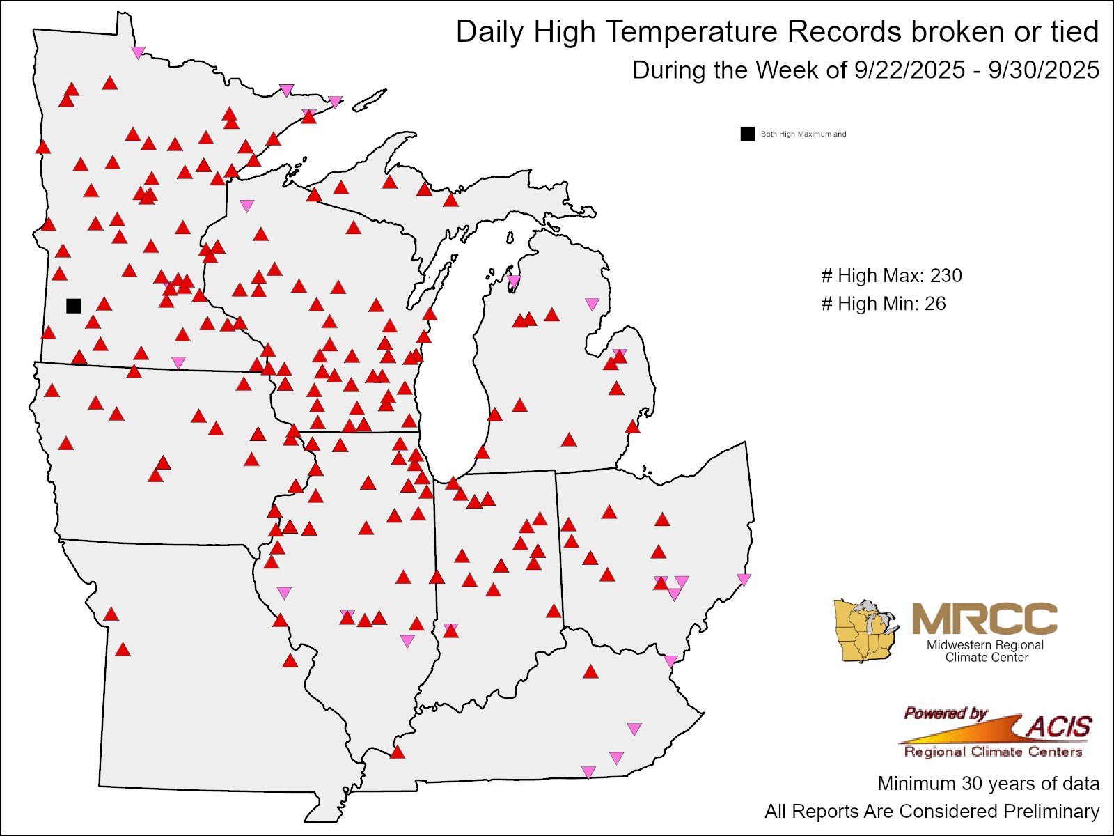
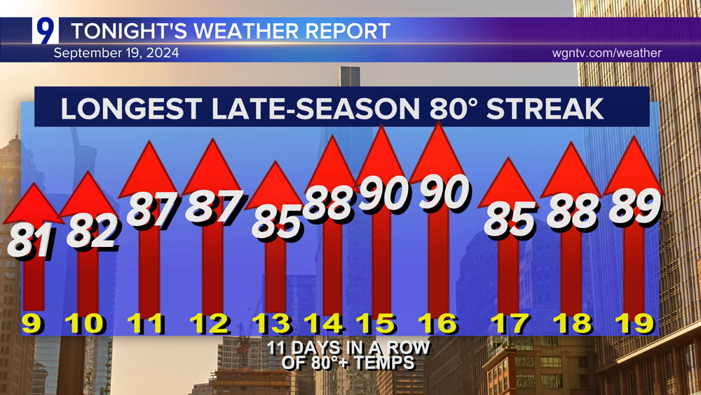
For Chicago Looks like Detroit is also at an 11-day streak over 80 but I’m not sure if that is the longest in September
-
Met summer in Grand Rapids ended with above normal temperatures and precipitation… so WAW summer (warm and wet)?
-
Summer 2024 Medium/Long Range Discussion
Danny8 replied to Chicago Storm's topic in Lakes/Ohio Valley
Is there an easy way to look up historical dew point data? Monthly and daily data? or is that something you have to back into with temp and humidity data. -
Very interesting analysis! Those 38 degree annual mean years in 1843 and 1875 are insane. Wouldn’t that technically qualify as like a subarctic climate??
-
For the US side of the eastern lakes it looks like Buffalo, Cleveland, and Detroit all finished in the top 10% of warmest Junes on record (going back to the 1870s)