Brian D
-
Posts
3,100 -
Joined
-
Last visited
Content Type
Profiles
Blogs
Forums
American Weather
Media Demo
Store
Gallery
Everything posted by Brian D
-
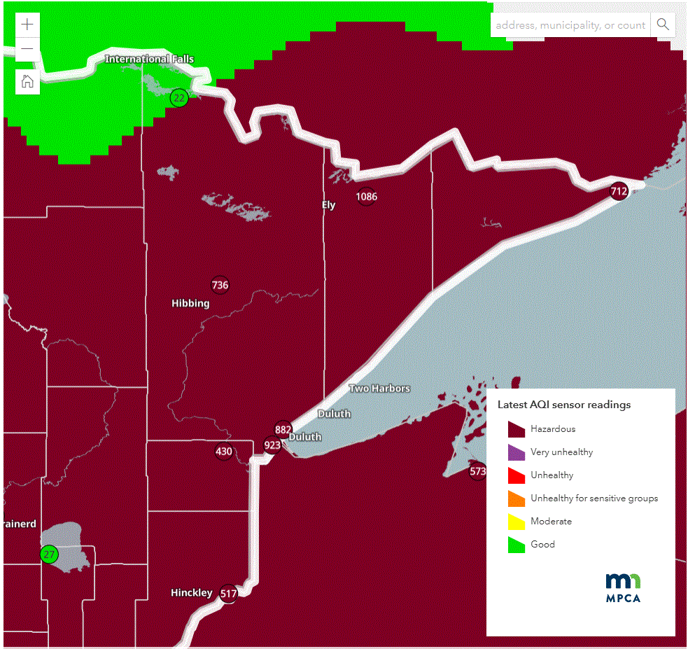
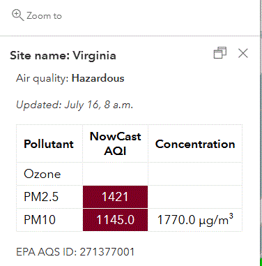
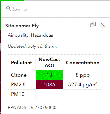
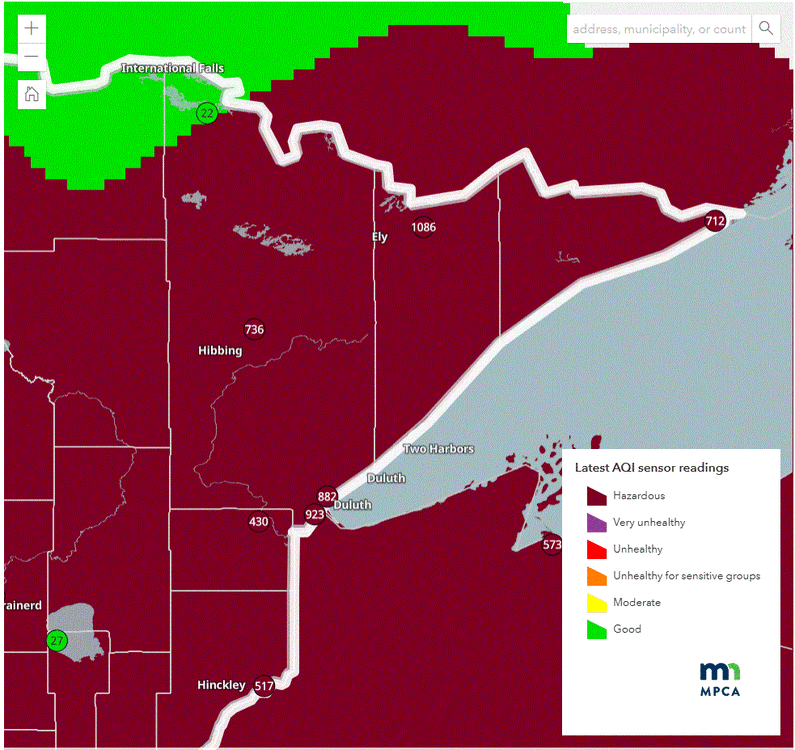
Radical. Hibbing /Virginia area just updated on the map. With HP overhead, air is stagnant atm.
-
Horrible AQI in NE MN. Similar to yesterday.
-
And it continues. "Sigh"
-
July 16 2006: A heat burst occurs over west central and central Minnesota. The temperature at Canby jumped from 91 degrees to 100 degrees in 40 minutes from 10:35pm to 11:15pm. At the same time the dew point temperature dropped from 63 to 32 degrees. Heat bursts are caused by dying thunderstorms with very warm air aloft. 1963: A downpour falls at St. Charles, where half a foot of rain accumulates in one day. For Thursday, July 16, 2026 1920 - A severe hailstorm over parts of Antelope and Boone counties in Nebraska stripped trees of bark and foliage, ruined roofs, and broke nearly every window facing north. (The Weather Channel) 1946 - The temperature at Medford, OR, soared to an all-time high of 115 degrees to begin a two week heat wave. During that Oregon heat wave the mercury hit 100 degrees at Sexton Summit for the only time in forty years of records. (David Ludlum) (The Weather Channel) 1975 - An early afternoon thunderstorm raked the east side of Tucson, AZ, with gale force winds, heavy rain, and numerous lightning strikes. A thirteen year old boy was swept through a forty foot long culvert by raging waters before being rescued. (The Weather Channel) 1987 - Showers and thunderstorms in the southwestern U.S. ended a record string of thirty-nine consecutive days of 100 degree heat at Tucson, AZ. A thunderstorm at Bullhead City, AZ, produced wind gusts to 70 mph reducing the visibility to near zero in blowing dust. Southerly winds gusting to 40 mph pushed temperature readings above 100 degrees in the Northern Plains. Rapid City, SD, reported a record high of 106 degrees, following a record low of 39 degrees just three days earlier. (The National Weather Summary) (Storm Data) 1988 - Thirty-seven cities in the eastern U.S. reported record high temperatures for the date. Highs of 96 degrees at Bluefield, WV, and 104 degrees at Charleston WV were all-time records, and afternoon highs of 98 degrees at Binghamton, NY, 99 degrees at Elkins, WV, and 103 degrees at Pittsburgh PA, tied all- time records. Highs of 104 degrees at Baltimore, MD, and 105 degrees at Parkersburg WV were records for July, and Beckley, WV, equalled their record for July with a high of 94 degrees. Martinsburg, WV, was the hot spot in the nation with a reading of 107 degrees. Afternoon and evening thunderstorms raked the northeastern U.S. with large hail and damaging winds. (The National Weather Summary) 1989 - Showers and thunderstorms developing along a stationary front drenched the Middle Atlantic Coast States with heavy rain, causing flooding in some areas. More than five inches of rain was reported near Madison and Ferncliff, VA. Hot weather prevailed in Texas. San Angelo reported a record high of 106 degrees. (The National Weather Summary) Observances: 16 Thu National Cherry Day 16 Thu World Snake Day 16 Thu Artificial Intelligence Appreciation Day 16 Thu Manu’a Cession Day (in lieu) 16 Thu National Atomic Veterans Day 16 Thu National Corn Fritters Day 16 Thu National D.R.E.S.S. Syndrome Day 16 Thu National Personal Chef Day 16 Thu National Wedding Invitation Day 16 Thu Our Lady of Mount Carmel 16 Thu Rural Transit Day 16 Thu The Feast of Our Lady of Mount Carmel 16 Thu Guinea Pig Appreciation Day 16 Thu Fresh Spinach Day
-
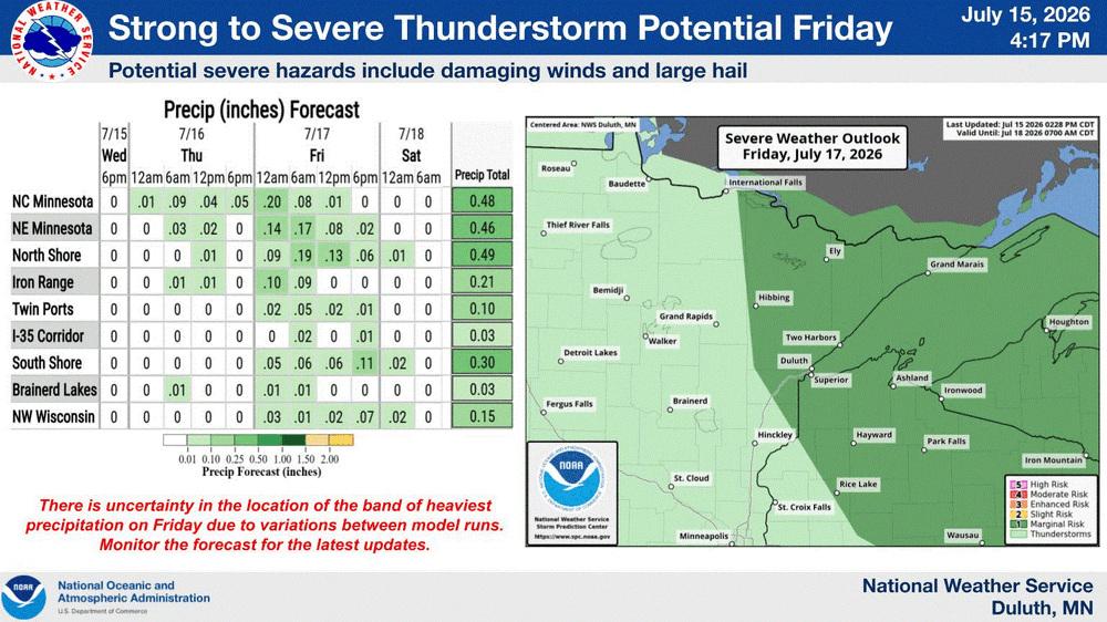
Will be looking forward to some stm action Friday. Much better than all this smoke.
-
Well, in due time. I like to enjoy seasons 1 at a time
-
How much do you have? Just a fine coating? EDIT: Take measurements if you can and report in to the MQT office. I'm sure they would love to know how much. They might be getting it too.
-
Duluth Cam looking over the harbor.
-
July 15 1980: Straight-line winds of nearly 100 mph cause enormous damage, mainly in Dakota County. 43 million dollars in damage is reported and 100 thousand people lose power. For Wednesday, July 15, 2026 1916 - A dying South Atlantic Coast storm produced torrential rains in the southern Appalachian Mountains. Altapass, NC, was drenched with more than 22 inches of rain, a 24 hour rainfall record for the state. Flooding resulted in considerable damage, particularly to railroads. (David Ludlum) 1954 - The temperature at Balcony Falls, VA, soared to 110 degrees to establish a state record. (The Weather Channel) 1983 - The Big Thompson Creek in Colorado flooded for the second time in seven years, claiming three lives, and filling the town of Estes Park with eight to ten feet of water. (The Weather Channel) 1987 - Unseasonably cool weather spread into the south central and eastern U.S. Fifteen cities reported record low temperatures for the date, including Houghton Lake, MI, with a reading of 37 degrees. The high temperature for the date of 58 degrees at Flint, MI, was their coolest of record for July. Thunderstorms spawned several tornadoes in Illinois and Indiana, injuring a cow near Donovan, IL. (The National Weather Summary) (Storm Data) 1988 - Twenty-six cities east of the Mississippi River reported record high temperatures for the date. Charleston, WV, established an all-time record high with a reading of 103 degrees, and Chicago, IL, reported a record fifth day of 100 degree heat for the year. A severe thunderstorm moving across Omaha, NE, and the Council Bluffs area of west central Iowa spawned three tornadoes which injured 88 persons, and also produced high winds which injured 18 others. Winds at the Omaha Eppley Airport reached 92 mph. Damage from the storm was estimated at 43 million dollars. (Storm Data) (The National Weather Summary) 1989 - Thunderstorms drenched Kansas City, MO, with 4.16 inches of rain, a record for the date. Two and a half inches of rain deluged the city between Noon and 1 PM. Afternoon thunderstorms in South Carolina deluged Williamstown with six inches of rain in ninety minutes, including four inches in little more than half an hour. (The National Weather Summary)(Storm Data) Observances: 15 Wed National Hot Dog Day 15 Wed National Give Something Away Day 15 Wed National Clean Beauty Day 15 Wed Blackcurrant Day 15 Wed Celebration of the Horse Day 15 Wed Developmental Disability Professionals Day 15 Wed National Be A Dork Day 15 Wed National Gummi Worm Day 15 Wed National I Love Horses Day 15 Wed National Pet Fire Safety Day 15 Wed National Tapioca Pudding Day 15 Wed Orange Chicken Day 15 Wed World Youth Skills Day
-
Smoke is nasty here too. Had to get up very early, and shut the windows. What a rude awakening. Temps in the 70's today tho. Update: Rain just moved in. Hopefully that help some.
-
Official record at the co-op doesn't have a 100 reading since 1894, and only 3 99's. This was met at a PWS a couple blocks from my house, so it will not be an official record. I hit 100 at my house once in the mid 90's that I recall. It is rare to be sure to see 100's in NE MN. At DLH, 3 100's were recorded in the 1936 heatwave. It really takes special circumstances to get 100 here. Even hitting 95 is a chore. Last night, and again tonight in my house, it reached 85. Will be opening windows very soon This was an impressive heatwave! (and glad it's ending)
-
100/77/117. Down slope effect kicked in good over the last hour. That should be the peak I would think. W wind 5-10.
-
WOW, the wind just switched to the W, and temps jacked 98/75/112.
-
Because the source is so close, will be a nasty day with surface haze, and smell.
-
Temps are peaking now. 92/74/102. Highest dew of the stretch, and I can tell. Smoke, and mid to upper 80's tomorrow will feel reasonable with 80-85 the rest of the week. Lake influence will be a little stronger with the chance of stms for the end of the week.
-
Yesterday's heat.
-
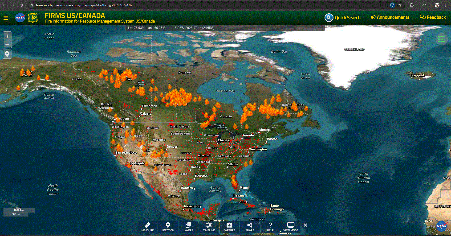
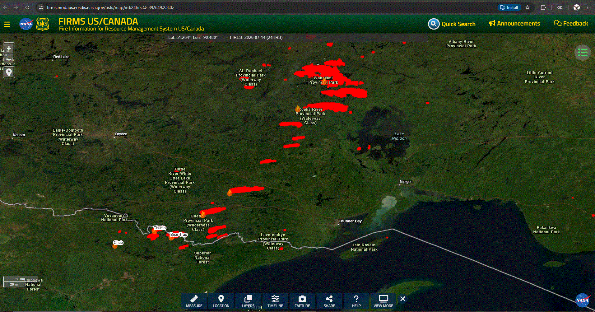
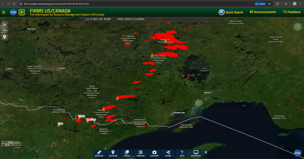
Wildfire season well under way in NA.

-
There are currently 17 wildfires in the BWCA. Was closed, and is being evac'd. Major fires to the N in CAN. Smoke will be moving through here tomorrow.
-
July 14 2003: At least eleven tornadoes hit Minnesota. Baseball-sized hail is reported at Indus in Koochiching County. 1936: The all-time record high is reported in the Twin Cities, with 108 degrees at the downtown Minneapolis office. 71 people would die in the Twin Cities on this day due to the extreme heat. 1916: Heavy downpours at New Ulm dump over seven inches of rain in seven hours. For Tuesday, July 14, 2026 1936 - Extreme heat prevailed across the central U.S. as severe drought raged from Texas to the Dakotas. Record high temperatures were established in sixteen states that summer, including readings as high as 120 degrees in the Great Plains Region. On this particular date, afternoon highs for 113 stations across the state of Iowa averaged 108.7 degrees. (David Ludlum) 1957 - Hail, with some stones up to an inch in diameter, covered the ground to a depth of three inches ruining crops in the Bath area of New Hampshire. (The Weather Channel) 1987 - Severe thunderstorms in Iowa produced eight inches of golf ball size hail near Grafton, IA, completely stripping corn stalks in the area. Hail caused more than a million dollars damage to crops in Worth County and Mitchell County, and another million dollars damage in Ada County and Crawford County. Unseasonably cool weather prevailed in the Great Plains Region. Eight cities reported record low temperatures for the date, including Duluth, MN, with a reading of 37 degrees. (The National Weather Summary) (Storm Data) 1988 - Severe thunderstorms produced large hail and damaging winds in the Northern Atlantic Coast Region during the afternoon and evening hours. Thunderstorms also spawned a rather strong tornado near Westtown, NY, and drenched Agawam, MA, with four inches of rain. (The National Weather Summary) (Storm Data) 1989 - Afternoon and evening thunderstorms produced severe weather from eastern New Mexico to central Nebraska. One hundred soldiers were injured by flying debris and collapsing tents during a thunderstorm near Trinidad, CO. Thunderstorms in Colorado produced wind gusts to 77 mph at La Junta. Early morning thunderstorms produced torrential rains over parts of Louisiana, with 7.50 inches at Carencro, and 5.85 inches at Morgan City. (Storm Data) (The National Weather Summary) 2005 - Death Valley had 7 consecutive days (July 14-20) with high temperatures equal to or above 125 degrees. Observances: 14 Tue Bastille Day 14 Tue National Mac and Cheese Day 14 Tue Cow Appreciation Day 14 Tue Pandemonium Day 14 Tue International Non-Binary Peoples Day 14 Tue National Grand Marnier Day 14 Tue National Tape Measure Day 14 Tue Shark Awareness Day 14 Tue National Be Nice to Bugs Day 14 Tue National Break Free From the Big Three Day
-
Point now says 97 today with a SW wind again, but then smoke arrives Wed. Just a matter of time for that to happen again.
-
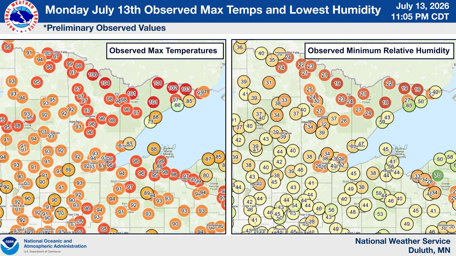
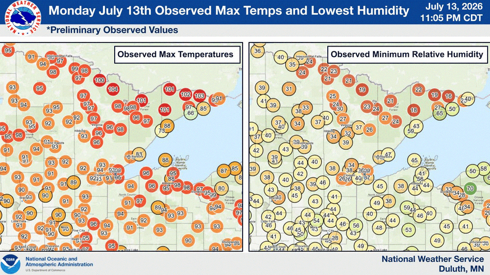
Just looked at DLH temp records, and looks like top 5 max temps with record/near record high mins. Some other stns should be near record/record max/hmin with shorter records. Stout heatwave for the Northland.
-
Temps peaked at 94/69/99. Shoreline temps running 85-90. Co-op had 83 yesterday. Offshore bouy for TH has an air temp of 56, so pretty chilly out there on the big pond. Point has 100 for tomorrow due to the winds switching to the W creating a little down slope enhancement. In house temp started at 79 and now to 83. Started at 75 yesterday, and ended with 82. Will open windows again tonight. Actually not horrible with the fans. I'm doing good.
-
More 100+ readings showing up near the border, even Thunder Bay, CAN. Looks like some 100's over in the UP MI, as well.
-
A couple 100 readings up near the border currently. One in Meander (RAWS), and another from a PWS just N of Seagull Lake. Some other sites are getting close.
-
Suppose to be the hottest of the heatwave today. Lets see if anyone hits 100. As noted below, the Lake cooled some with SW winds yesterday, so that might keep things in check here in town. Winds are to be breezy out of the SW again. .UPDATE... Issued at 253 AM CDT Mon Jul 13 2026 We remain trapped under the influence of a stout upper level high pressure today. With 2AM temperatures still in the 70s across the Northland (outside of some areas right along Lake Superior on the North Shore), today will provide little to no relief from the ongoing heat wave. Guidance continues to point towards today being the hottest day of the heat event. High temperatures could touch or even exceed 100F for the Borderlands in Koochiching, northern St. Louis, and inland Lake/Cook Counties while high temperatures in the 90s are expected across the rest of the Northland. An Extreme Heat Warning continues through the day for the entire area except Price County. The Extreme Heat Warning for areas along and south of Hwy 2 in MN and everywhere in NW WI except Price County has been extended through Tuesday evening due to another very warm night and afternoon expected in those areas. Once the warning expires for the areas north of Hwy 2 in MN, a Heat Advisory will likely be needed at least through Tuesday evening there. In Price County, the Heat Advisory has been extended to run through at least Tuesday evening. A Heat Advisory may be needed along our southern tier of counties for Wednesday. One small note of uncertainty: there has been significant upwelling of cold water in Lake Superior from Duluth to Two Harbors due to the southwest winds over the last 24 hours. This could affect temperatures today very close to the lake, similar to the extremely tight temperature gradient we have seen further up the North Shore. For now, have opted to stay on the hotter side for much of the forecast.