Brian D
-
Posts
3,305 -
Joined
-
Last visited
Content Type
Profiles
Blogs
Forums
American Weather
Media Demo
Store
Gallery
Everything posted by Brian D
-
April 16 1939: A rain, snow, sleet and ice storm begins across southern Minnesota. Despite many phone and power outages, farmers are jubilant that the storm brings needed moisture. For Thursday, April 16, 2026 1851 - The famous "Lighthouse Storm" raged near Boston Harbor. Whole gales and gigantic waves destroyed Minot Light with its two keepers still inside. The storm resulted in great shipping losses and coastal erosion. (David Ludlum) 1880 - A tornado near Marshall, MO, carried the heavy timbers of an entire home a distance of twelve miles. (The Weather Channel) 1933 - Franklin Lake, NH, was buried under 35 inches of snow. (Sandra and TI Richard Sanders - 1987) 1960 - A wind gust of 70 mph was measured at the Stapleton International Airport in Denver CO, their highest wind gust of record. (The Weather Channel) 1987 - A slow moving storm system produced heavy rain over North Carolina and the Middle Atlantic Coast States. More than six inches of rain drenched parts of Virginia, and flooding in Virginia claimed three lives. Floodwaters along the James River inundated parts of Richmond VA. (The National Weather Summary) (Storm Data) 1988 - A storm in the northeastern U.S. produced a foot of snow at Pittsburg VT. Severe thunderstorms produced baseball size hail and spawned five tornadoes in the Southern High Plains Region. (The National Weather Summary) (Storm Data) 1989 - A cold front, ushering sharply colder air into the north central U.S., brought snow to parts of Montana and North Dakota. At midday the temperature at Cutbank MT was just 22 degrees. (The National Weather Summary) (Storm Data) 1990 - Thunderstorms developing along a stationary front produced large hail and damaging winds across Oklahoma, with 99 reports of large hail and damaging winds during the evening and early nighttime hours. Thunderstorms produced baseball size hail south of Carney, and wind gusts to 100 mph in the Oklahoma City area which swept away many Federal tax returns being transported from a mail cart to a waiting truck about the time of the midnight deadline. Will Rogers Airport in Oklahoma City reported a record wind gust of 92 mph. (The National Weather Summary) (Storm Data)
-
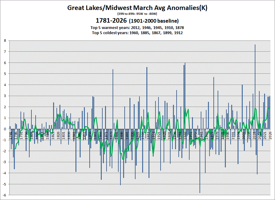
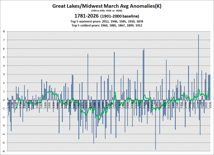
Early data in for March. Another warm one. 5 & 10 yr trend charts shown respectively.
-
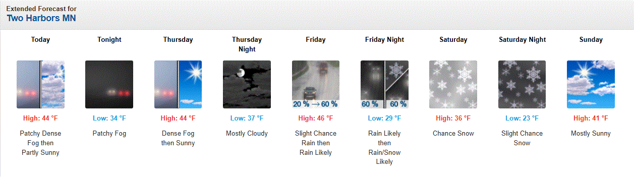
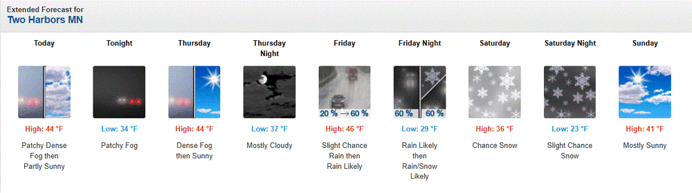
Well, it is still April in the Northland. Bouts of chilly wx still in the pipeline.
-
Eeked out about 0.10" of rain yesterday from the heavy drizzle, and shwrs/stms that developed over the area. Was nice to have stms for a change. Geese have been trickling back into the area as well as flocks of tweety birds. No robin sightings yet, but that'll come soon.
-
April 15 2002: An early heat wave overtakes Minnesota. Faribault hits 93 degrees, and the Twin Cities would experience their earliest recorded 90 degree temperature with a high of 91. For Wednesday, April 15, 2026 1921 - Two mile high Silver Lake, CO, received 76 inches of snow in 24 hours, the heaviest 24 hour total of record for North America. The storm left a total of 87 inches in twenty-seven and a half hours. (David Ludlum) 1927 - New Orleans LA was drenched with 14.01 inches of rain, which established a 24 hour rainfall record for the state. (The Weather Channel) 1949 - A hailstone five inches by five and a half inches in size, and weighing four pounds, was measured at Troy NY. (The Weather Channel) 1958 - A tornado 300 yards in width skipped along a five mile path near Frostproof FL. A 2500 gallon water tank was found one mile from its original position (it is not known how much water was in the tank at the time). (The Weather Channel) 1987 - Thunderstorms developing along a cold front produced severe weather in the Southern Atlantic Coast Region. A tornado killed one person and injured seven others near Mount Dora FL. Drifts of hail up to two feet deep were reported in Davidson and Rowan counties in North Carolina. Myrtle Beach SC was deluged with seven inches of rain in three hours. (The National Weather Summary) (Storm Data) 1988 - Death Valley, CA, was soaked with 1.53 inches of rain in 24 hours. Snow fell in the mountains of southern California. (The National Weather Summary) (Storm Data) 1989 - Showers and thunderstorms soaked the eastern U.S. with heavy rain, pushing the rainfall total for the month at Cape Hatteras NC past their previous April record of 7.10 inches. (Storm Data) (The National Weather Summary) 1990 - Thunderstorms developing along a stationary front produced severe weather from west central Texas to west central Arkansas during the late afternoon and evening. Thunderstorms spawned a tornado which caused more than half a million dollars damage at Fort Stockton TX, produced wind gusts to 65 mph at Dennison TX, produced baseball size hail at Silo OK and near Capps Corner TX, and drenched southeastern Oklahoma with up to 4 inches of rain in two hours. (The National Weather Summary) (Storm Data) Note: The 1927 record for rainfall in 24 hrs was eclipsed on Aug 29, 1962 at 22.00" from a tropical disturbance in the Sabine National Wildlife Refuge in Hackberry, LA.
-
13.6" is the daily record which still stands for April, but stm total does go to the 2018 event.
-
April 14 1983: A 'surprise' snowstorm covers east central Minnesota. The Twin Cities receives 13.6 inches, the all-time record for April. Brilliant blue skies and bright sun appear the next morning. 1886: The deadliest tornado in Minnesota's history rips through St. Cloud and Sauk Rapids, leaving 72 people dead. 80 percent of all buildings in Sauk Rapids would be leveled as the tornado's width expanded to 800 yards. As it crossed the Mississippi it knocked down two iron spans of a wagon bridge and local witnesses said the river was 'swept dry' during the tornado crossing. 300,000 dollars damage would occur in Sauk Rapids, only 4,000 dollars of which was insured. The forecast for that day was for local rains and slightly warmer with highs in the 50's. For Tuesday, April 14, 2026 1873 - A famous Easter blizzard raged across Kansas, Nebraska and South Dakota. Gale force winds blew the wet snow into massive drifts, however there were few deaths due to the sparse population and due to the gradual increase of the storm. (David Ludlum) 1886 - A devastating tornado, 800 yards in width at times, cut a twenty mile path through Saint Cloud MN killing 74 persons. The bottom of the Mississippi River was said to have been seen during the tornado's crossing. Eleven persons were killed at a wedding party near the town of Rice. (David Ludlum) (The Weather Channel) 1987 - A storm system moving slowly northeastward across the Middle Mississippi Valley produced severe thunderstorms which spawned three tornadoes around Ottumwa IA, and produced up to four inches of rain in southeastern Nebraska, flooding rivers and streams. (The National Weather Summary) (Storm Data) 1988 - A weather disturbance off the southern coast of California brought parts of southern California their first rain in six weeks. Rain-slickened roads resulted in numerous accidents in southern California, including a ten car pile-up at Riverside. (The National Weather Summary) (Storm Data) 1989 - Late afternoon thunderstorms in northern Florida soaked the town of Golden Gate with 4.37 inches of rain in about two hours, resulting in local flooding. (The National Weather Summary) (Storm Data) 1990 - Thunderstorms developing along a cold front produced severe weather in southeastern Texas during the mid morning hours. Thunderstorms produced dime size hail at Galveston, and wind gusts to 59 mph at Port Arthur. Afternoon thunderstorms over southeast Louisiana spawned tornadoes south of Bogalusa and at Rio. (Storm Data)
-
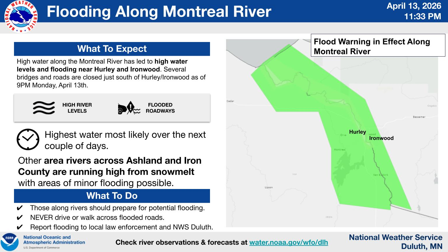
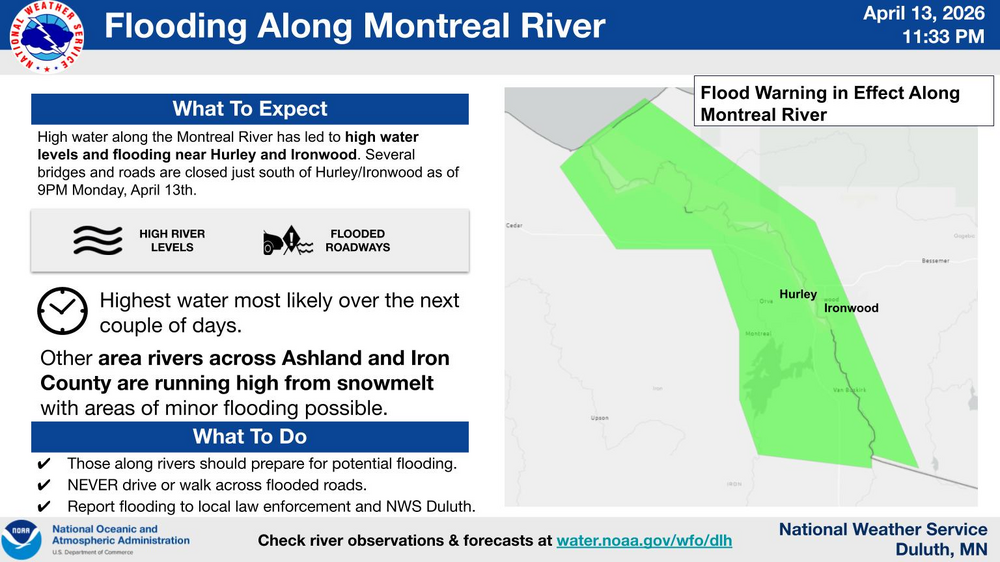
+DR(-RN) under overcast skies with a lake breeze and a 37 temp. ISH! But it is April (mud month). Most of the snow is gone except for some piles, and large drifts here in town. Montreal River over on the WI/UP MI border flooding right now, too, closing roads/bridges.
-
On a lighter note, my tribute to the successful Artemis mission
-
We just keep heading headlong into this crap. Totally OT for wx stuff, but... Feelin' like it's all over Feelin' like there's no love Feelin' like it's not easy Breathin' life in the dust On a countdown to zero Take a ride on the nightmare machine There ain't gonna be heroes There ain't gonna be anything, oh Here it comes, here comes the night Here it comes, hell in the night Here it comes, here comes the night When we all fall down When we walk into silence When we shadow the sun When we surrender to violence When the damage is done Put away that gun I don't wanna be there I don't wanna be anywhere, oh Here it comes, here comes the night Here it comes, hell in the night Here it comes, here comes the night That's right We're fightin' for the gods of war But what the hell we fightin' for? We're fightin' with the gods of war But I'm a rebel And I ain't gonna fight no more, no way On a countdown to zero Take a ride on the nightmare machine There ain't gonna be heroes, whoa There ain't gonna be anything, no Here it comes, here comes the night Here it comes, hell in the night Here it comes, here comes the night Don't ya know that's right? We're fightin' for the gods of war But what the hell we fightin' for? We're fightin' with the gods of war And I ain't gonna fight no more Stop (stop fightin' for the gods of war) stop fightin' for the gods of war (Yeah, what the hell we fightin' for?) What the hell we fightin' for? (We're fightin' with the gods of war) Heavy! "Message to terrorists everywhere, You can run, but you can't hide" "We're determined to stand together and we're determined to take action" "We're not going to tolerate these attacks from outlaw states" "We will not cave in" "Today, we have done what we had to do" "He counted on America to be passive. He counted wrong"
-
April 13 1949: A late-season snowstorm dumps over 9 inches in parts of the Twin Cities metro area. For Monday, April 13, 2026 1877 - The second coastal storm in just three days hit Virginia and the Carolinas. The first storm flattened the sand dunes at Hatteras, and widened the Oregon inlet three quarters of a mile. The second storm produced hurricane force winds along the coast of North Carolina causing more beach erosion and land transformation. (David Ludlum) 1955 - The town of Axis, AL, was deluged with 20.33 inches of rain in 24 hours establishing a state record. (The Weather Channel) 1986 - A major spring storm quickly intensified bringing blizzard conditions to much of the Northern Plains Region. Up to 18 inches of snow was reported in North Dakota, and in South Dakota, winds gusting to 90 mph whipped the snow into drifts fifteen feet high. Livestock losses were in the millions of dollars, and for some areas it was the worst blizzard ever. (Storm Data) 1987 - Thunderstorms in northern Texas produced wind gusts to 98 mph at the Killeen Airport causing a million dollars property damage. Two airplanes were totally destroyed by the high winds, and ten others were damaged. (The National Weather Summary) (Storm Data) 1988 - Low pressure off the Atlantic coast produced high winds across North Carolina, with gusts to 78 mph reported at Waves. The high winds combined with high tides to cause coastal flooding and erosion. About 275 feet of land was eroded from the northern tip of Pea Island. (The National Weather Summary) (Storm Data) 1989 - Thunderstorms in central Florida produced golf ball size hail and a tornado near Lakeland FL. Fair and mild weather prevailed across most of the rest of the nation. (Storm Data) (The National Weather Summary) 1990 - Thunderstorms developing along a cold front produced severe weather in central Oklahoma and north central Texas. Thunderstorms in Oklahoma produced up to six inches of golf ball size hail along I-40 near El Reno, and produced wind gusts to 75 mph at Okarche. Thunderstorms over north central Texas produced softball size hail northwest of Rotan, and high winds which injured two persons southeast of Itasca. (The National Weather Summary) (Storm Data) 2004 - The latest measurable snowfall on record hits Jackson, TN, causing six traffic fatalities. 2006 - The University of Iowa campus is hit by an F2 tornado. The storm severely damaged many buildings in the area, including a sorority and a local church. No fatalities were reported in the storm that caused more than $12 million in damage.
-
I take it they got there in time to put it out?
-
Up to 1" hail from some small cells that moved through.
-
Spring is inching its way N.
-
0.42" of rain this morning with an overcast, drizzly morning. Precip started yesterday aftrn as a rn/sl mix before going over to all rain. Cold, damp wx. ISH!
-
April 12 1931: July-like temperatures are felt across the area with 90 degrees at Beardsley in west central Minnesota. For Sunday, April 12, 2026 1927 - A tornado wiped out the town of Rock Springs, TX, killing 72 persons and causing 1.2 million dollars damage. The tornado, more than one mile in width, destroyed 235 of 247 buildings, leaving no trace of lumber or contents in many cases. Many survivors were bruised by large hail which fell after the passage of the tornado. (David Ludlum) (The Weather Channel) 1934 - Winds atop Mount Washington, NH, averaged 186 mph for five minutes, with a peak gust of 231 mph, the highest wind speed ever clocked in the world. (David Ludlum) 1987 - A cold front crossing the central U.S. produced heavy snow in the Central Rockies, and severe thunderstorms over Kansas and Oklahoma. Snowfall totals ranged up to 16 inches at Red Mountain Pass CO. Thunderstorm winds gusted to 87 mph at Ponca City OK. Winds associated with the cold front itself gusted to 69 mph at Tucumcari NM. (The National Weather Summary) (Storm Data) 1988 - Snow blanketed the Southern Appalachians. Totals in North Carolina ranged up to 17 inches at Mitchell. Winds at Flat Top Mountain gusted to 80 mph. (The National Weather Summary) (Storm Data) 1989 - Twenty-two cities in the south central and eastern U.S. reported record low temperatures for the date, including Elkins WV with a low of 15 degrees, and Baton Rouge LA with a reading of 37 degrees. (The National Weather Summary) 1990 - Arctic air invaded the central U.S. Lincoln, NE, reported a record low of 17 degrees. Thunderstorms developing along the arctic cold front produced heavy snow in north central Kansas, wind gusts to 61 mph at Midland TX, and wind gusts to 69 mph at Rawlins WY. Warm weather prevailed in the southwestern U.S. Las Vegas NV reported a record high of 91 degrees, and on the 13th, Sacramento CA reported a record high of 95 degrees. (Storm Data) (The National Weather Summary) 2010 - One-inch diameter hail falls in Fresno, CA. Two condominiums are destroyed by thunderstorms in California's San Joaquin Valley. Up to three funnel clouds were also seen in the region. Note: That wind speed record was eclipsed on April 10, 1996 with Tropical Cyclone Olivia in AUS with a wind speed of 254 mph. But the Mt Washington record still stands as fastest non cyclonic/tornadic straight line wind. These are anemometer records. The fastest was a Doppler on Wheels (DOW) radar sig with the 1999 Bridge Creek–Moore tornado between Oklahoma City and Moore, Oklahoma, 3 May 1999. Wind speed analysis of 321 mph.
-
April 11 1929: An intense downpour occurs in Lynd, Minnesota (near Marshall), where 5.27 inches of rain would fall in 24 hours. For Saturday, April 11, 2026 1965 - Severe thunderstorms in the Upper Midwest spawned fifty-one tornadoes killing 256 persons and causing more than 200 million dollars damage. Indiana, Ohio and Michigan were hardest hit in the "Palm Sunday Tornado Outbreak". (David Ludlum) 1987 - Ten days of flooding in the northeastern U.S. finally came to an end. Damage from flooding due to rain and snow melt ran into the billions of dollars. The collapse of the New York State Thruway Bridge over Schoharie Creek claimed ten lives. (Storm Data) 1988 - Sixteen cities in the western U.S., nine in California, reported new record high temperatures for the date. Afternoon highs of 95 degrees at Sacramento CA and 96 degrees at Bakersfield CA were the warmest of record for so early in the season. (The National Weather Summary) 1989 - Forty-four cities in the south central and eastern U.S. reported new record low temperatures for the date. Lows of 25 degrees at Conway AR, 29 degrees at Dallas/Fort Worth TX, and 22 degrees at Ozark AR, were April records. Lows of 26 degrees at Hot Springs AR and 31 degrees at Shreveport LA equaled April records. (The National Weather Summary) 1990 - While showers produced heavy rain over much of the northeastern U.S., heavy snow blanketed northern Maine, with 13 inches reported at Telos Lake. Strong southwesterly winds accompanying the rain and snow gusted to 68 mph at the Blue Hill Observatory in Massachusetts. Rainfall totals of 1.04 inch at Pittsburgh PA and 1.52 inch at Buffalo NY on the 10th were records for the date. (The National Weather Summary) (Storm Data)
-
Looks like the rivers along the shore are going to be roaring next week. Gooseberry Falls should be a cool site to visit.
-
April 10 1977: A record high of 86 is set at Redwood Falls. For Friday, April 10, 2026 1894 - A heavy late season snow blanketed parts of the northeastern U.S. Heavier snowfall totals included 31.5 inches at Salem Corners PA, 30 inches at LeRoy NY, 26 inches at York PA, 14 inches at Waterbury CT, and 9 inches at Providence RI. (The Weather Channel) 1935 - Severe dust storms across Iowa and Kansas closed schools and highways. Dodge City KS experienced its worst dust storm of record, with dense dust reported from the morning of the 9th until after sunset on the 11th. The sky was almost as dark as night at times during the daylight hours. The thick dust suspended traffic on highways and railroads, and also suspended most business in town. (The Weather Channel) 1979 - A massive tornado smashed into Wichita Falls, TX, killing 43 persons and causing 300 million dollars damage. Another tornado struck Vernon TX killing eleven persons. (David Ludlum) (Storm Data) 1987 - Blustery northwest winds prevailed across the Northern Plains Region. Winds in Wyoming gusted to 65 mph. Temperatures in North Dakota were only in the 20s and 30s, following afternoon highs in the 70s the previous day. (The National Weather Summary) 1988 - Unseasonably warm weather prevailed in the western U.S. Eleven cities reported new record high temperatures for the date, including Bakersfield CA with a reading of 95 degrees, their warmest for so early in the season. Pocatello ID warmed from a record low of 19 above to an afternoon high of 63 degrees. (The National Weather Summary) 1989 - Strong northerly winds, gusting to 53 mph at Albuquerque, NM, ushered cold arctic air into the south central U.S. The temperature at Albuquerque plunged from 82 degrees to 29 degrees overnight. Thirty-three cities in the central U.S. reported record low temperatures for the date, including Goodland KS with a reading of 4 degrees above zero. (The National Weather Summary) 1990 - Thunderstorms produced severe weather from the Central Gulf Coast Region to western sections of the Carolinas during the afternoon and evening. Evening thunderstorms over western South Carolina produced wind gusts to 98 mph which injured four persons at Holly Springs, and wind gusts to 100 mph which injured one person and caused half a million dollars damage north of Dacusville. (The National Weather Summary) (Storm Data) 2005 - Heavy snow affected the Colorado Rockies during April 10-11, as up to 30 inches of snow affected the mountains around Denver. In the Denver metro area, 10-15 inches of snow accumulated.
-
From Dr. Roy Spencer's blog. https://www.drroyspencer.com/ Record Warmth in the Contiguous U.S. (Lower 48) For the Lower 48, the March 2026 temperature anomaly was easily the record warmest of all months in the 47+ year satellite record: +3.7 deg. C above average for all Marches. Second place goes to March 2012, with +2.2 deg. C above the mean, while 3rd place goes to December 2025 at +2.1 deg. C. Interestingly, December through April are periods of large variability for the Lower 48. All 6 of the warmest months (in terms of departures from normal) since 1979 occurred in December through April. Furthermore, all 8 of the coldest months occurred in December through April.
-
Was looking at drought data. I have this chart from a tree ring proxy study of the West, and pulled this chart for the west to extend the data using D2-4. Now what tree rings would look like over the past 25 yrs compared to the index I'm not sure, but this at least gives an idea of what we are seeing now to centuries past. Too bad there isn't historical proxy tree ring data for other parts of the country.
-
April 9 1931: Severe dust storms are reported in St. Paul. For Thursday, April 9, 2026 1877 - Oregon Inlet, NC, was widened three quarters of a mile by a nor'easter. (Sandra and TI Richard Sanders - 1987) 1947 - A tornado struck Woodward, OK, during the late evening killing 95 persons and causing six million dollars damage. The tornado, one to two miles in width, and traveling at a speed of 68 mph, killed a total of 167 persons along its 221 mile path from Texas into Kansas, injured 980 others, and caused nearly ten million dollars damage. (David Ludlum) A man looking out his front door was swept by a tornado from his home near Higgins TX and carried two hundred feet over trees. The bodies of two people, thought to be together at Glazier TX, were found three miles apart. (David Ludlum) (The Weather Channel) 1977 - A storm brought 15.5 inches of rain to Jolo, WV, in thirty hours. (The Weather Channel) 1987 - International Falls, MN, reported their sixth straight record high for the date, with a reading of 77 degrees. A cold front ushering sharply colder weather into the north central U.S. produced wind gusts to 60 mph at Glasgow MT. (The National Weather Summary) 1988 - Residents of Sioux City, IA, awoke to find two inches of snow on the ground following a record high temperature of 88 degrees the previous afternoon. (The National Weather Summary) 1989 - Eighteen cities in the southwestern U.S. reported new record high temperatures for the date. The afternoon high of 80 degrees at Eureka CA established a record for the month of April. (The National Weather Summary) 1990 - Thunderstorms developing ahead of a cold front produced severe weather from the Central High Plains to Arkansas and northern Texas. Severe thunderstorms spawned five tornadoes, and there were seventy reports of large hail and damaging winds. A tornado injured four persons at Ardmore OK, and thunderstorms produced wind gusts to 70 mph at Kellyville OK, and hail three inches in diameter at Halmstead KS. (The National Weather Summary) (Storm Data) 2011 - An EF-3 tornado hits Mapleton, IA. Officials estimate more than half the town is damaged or destroyed but none of the 1200 residents were killed. 31 tornadoes were confirmed across Iowa, Kentucky, Tennessee and North Carolina on this day.
-
April 8 1805: John Sayer at the Snake River Fir Trading Post near present day Pine City mentions: 'The most tempestuous (stormy) day of the year. Pines and other trees fell near the fort.' ^Note: Would seem a line of stms with strong straight line winds, or even a weak tornado, passed through EC MN region. A bit unusual this time of year this far N.^ For Wednesday, April 8, 2026 1919 - A tornado swarm in northern Texas resulted in the deaths of 64 persons. (David Ludlum) 1926 - The lightning-set oil depot fire near San Luis Obispo CA boiled over and engulfed 900 acres. Many tornado vortices resulted from the intense heat of the fire. One such tornado traveled 1000 yards, picked up a house and carried it 150 feet, killing the two occupants inside. (The Weather Channel) 1973 - A severe storm brought high winds and heavy snow to Iowa. Belle Plain received 20 inches of snow, and 19 inches blanketed Dubuque, record totals for both locations for so late in the season. Snow drifts up to sixteen feet high closed highways. (David Ludlum) 1987 - A cold front crossing the Northern Plateau and the Northern Rocky Mountain Region produced high winds in northeastern Wyoming. Winds gusting to 69 mph at Sheridan WY downed power lines and caused some property damage. (The National Weather Summary) (Storm Data) 1988 - Strong northerly winds ushered cold air into the north central U.S. The strong winds, gusting to 60 mph at Rapid City SD and Williston ND, reduced visibilities in blowing dust over the Dakotas. (The National Weather Summary) (Storm Data) 1989 - Two dozen cities in the southwestern U.S. reported new record high temperatures for the date. Phoenix AZ equaled their record for April of 104 degrees established just the previous day. (The National Weather Summary) 1990 - Twenty-two cities reported record low temperatures for the date as readings dipped into the 20s and 30s across much of the eastern U.S. Freezing temperatures severely damaged peach and apple orchards in West Virginia, where prolonged mild weather since January had caused an early blooming of spring vegetation. State and Federal agencies estimated a 50 percent loss in production for peaches and "Delicious Red Apples". (The National Weather Summary) (Storm Data) Note: That's one serious firenado WOW!
-
Chilly mixed bag Wed.
-
My granddaughter's wedding is Sat eve, so this will start just in time after that blessed day.