

csnavywx
-
Posts
4,335 -
Joined
-
Last visited
Content Type
Profiles
Blogs
Forums
American Weather
Media Demo
Store
Gallery
Posts posted by csnavywx
-
-
5 hours ago, A-L-E-K said:
how is it not over if we are already at the point where we can't control runaway microbial driven ch4 emissions
https://www.nature.com/articles/d41586-022-00312-2
Still more research to be done here, but the proportion of light (carbon 13 depleted), biogenic methane seems to be increasing.
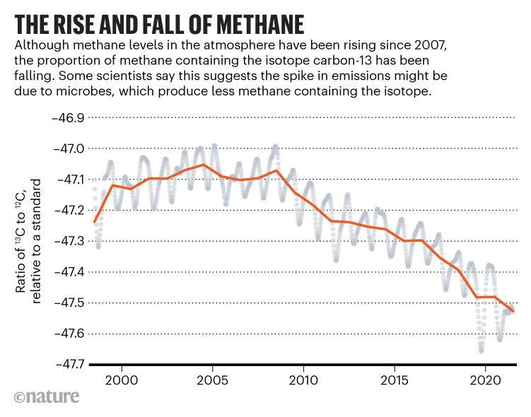
That's a big regime change from the pre-2005 era, going back to the Industrial Revolution-- where carbon-13 enriched CH4 was on a steady increase. While the research linked in the article wasn't conclusive, it does suggest that most of that increase in the last several years is microbial, and the NH/SH gradient in obs is best replicated when you assume it's coming from equatorial tropical and SH wetlands. That ~85% of this increase is likely microbial since 2005/06 is worrying. It doesn't debunk that it could have come mainly from an increase in FF extraction, but that theory is taking on water now, imo. It's much harder to do anything about wetland emissions -- and if this represents a significant feedback from increasing temp and rainfall, then that represents a world of hurt. Not sure how much higher those emissions can go, since a move of this magnitude wasn't really expected -- even the higher end scenarios I don't think had this kind of response until much later in the century.
Gonna be doing a lot more digging on this in the next few days.
-
 3
3
-
 1
1
-
-
On 1/1/2022 at 6:14 AM, chubbs said:
Doesn't look great to me. Very unscientific analysis - the trend since 2004 is much more uncertain than the trend since 1979; and doesn't look negligble either. Note that volume anomaly is higher in winter.
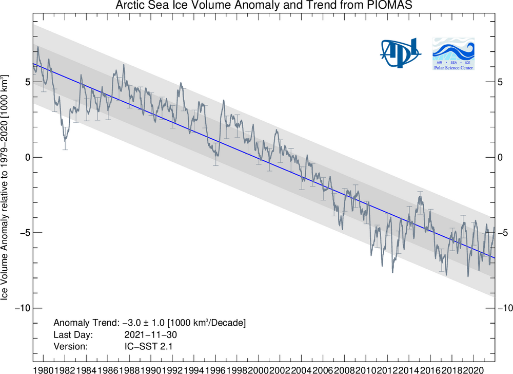
If he's tweeting it, it's a sure sign that we're near the top. These folks usually come out of the woodwork right before it tanks. Great contrarian signal if nothing else.
-
Congrats to everyone on the eastern shore! Big winners on that one -- even higher totals than I thought!
The coastal deformation zone merged nicely with the pre-event frontogen band and really delivered. Overperformed expectations here too, ended up slightly above 5", more than expected.
-
5
-
-
Band here in St. Mary's has slowed down to a crawl and the edge has pretty much stalled just a few miles to my northwest. Riding the edge here tonight. Still ripping here for now. Clearing past 2" atm.
-
11
-
-
Heavy snow now, ripping big dendritic aggregates.
-
10
-
-
Looking for 6-10" over for Lowershoresadness in the 'bury and eastern shore. 2-6" for the western coast of the Bay (slanted higher southwest). 1-3" west of there. The western side will pick up half or more of their snow from the pre-storm frontogenesis-driven event. I expect that to overperform a bit due to the fact that the lift is co-located across the DGZ and persists for hours before the coastal blows up. Those kinds of events are often a bit sneaky: they start early and can produce healthy dendrites and aggregates. Surface temps will start a smidgen warm, but ground temps are cold. It won't take long to get the boundary layer to cool off, unlike last week.
Subject to some revision due to where the coastal actually ends up setting up. If the 850/700mb lows end up a bit further NW and we stay SSE/SE at 500mb, totals will get bumped.
-
3
-
3
-
-
2 minutes ago, Solution Man said:
+150 qpf goes up
I'd take those odds.
It's not going to do a whole lot for DC on west perhaps, but on the western side of the Bay, yep.
-
2
-
-
13 minutes ago, WinterWxLuvr said:
This aged well lol
Voting against that sub-72 hour NW/W walk on the GFS is a dangerous bet.
Edited: It's usually 72, but strongest under 48.
-
6
-
-
6 hours ago, Lowershoresadness said:
just got outta work, someone fill me in
Still working out some issues with storm genesis location and time to "ramp up", which will make all the difference in the world. Still, a nice floor for S MD and Ern Shore of 2-4" so far. Considerably higher (6-8") with even a partial phase for the Eastern Shore and gangbusters if we can get the genesis location and speed right (8-12"). Blizz conditions not off the table either (for the coastline), but somewhat lower probability.
Will know more by 12z. Will issue a forecast here tomorrow afternoon after I get done doing stuff at work.
-
2
-
3
-
-
28 minutes ago, WinterFire said:
I don’t know if we like him anymore or not, and this might be wishcasting, but it is an interesting explanation of the 0z suite so far:
He's on the level. Was (correctly) poo-pooing the events last week because of the missed phase (among other issues). Personally, I want to see a continuation through 12z and no more "diurnal rocking" before committing.
-
3
-
2
-
-
9 hours ago, yoda said:
Ha, that's the first thing I thought when I saw those progs a few days ago. Looks just like a PRE setup, but in January. They can persist for some time and it's that kind of setup (mid-level f-gen max across the DGZ) that can overperform pretty nicely. Might end up being the thing that "saves" the event for most of the subforum.
-
7
-
-
Lotta despair in here for well -- not much of a good reason yet, from what I can see. Maybe the west side folks, but even that is going to cash in on high-ratio fluff from the long duration f-gen event ahead of the low. GFS is doing its typical gradual, but noisy walk NW in the short range. Does nobody remember last week?
-
9
-
6
-
-
I spy a deathband at 81/84 on the frontogen maps. Going to break out some bufkit and cross sections some time tonight and have some fun with that. The 700mb low closes off between 78-81, so I would expect there to be an especially intense band setting up N and W of that.
-
9
-
-
Surface cyclogenesis starts considerably earlier on this run, too. By tau 60-66.
-
8
-
-
2 minutes ago, Lowershoresadness said:
no you are correct. I remember we got whacked from back to back storms but the big daddy from one storm was 87. I remember the scrolling at the bottom of the TV saying expect 12 to 18 inches.
Ah, good stuff. Hopefully you cash in on this one too. Fingers crossed that you don't get into the mix zone.
-
2
-
-
7 minutes ago, bsperlin said:
https://en.wikipedia.org/wiki/Miller_Classification
Miller A - from the Gulf or Florida - Sandy 1993
Miller B - from the Ohio Valley, jumping the mountains to the Gulf Stream off NC - Snowmageddon 2010
If you have better references, please list them.
Right, genesis is off central FL coast and no discernable inland low. Not a Miller B.
-
1
-
-
2 minutes ago, Lowershoresadness said:
expectations can't get any lower at my location lol. I laugh at snow maps but who knows. Last big snow I remember was superbowl sunday 1987. I think the bury got over 14 inches
You got 11" and a blizzard warning a few years ago, right? '17/early '18 was it? Or am I misremembering that one.
-
2
-
-
It does look like we're going to get another swing at it in this pattern later this week. The chance of a repeat "phase-miss" is lower this time. Regular reminder not to get too carried away with any one run or model. I want to see this trend stick through the 12z guidance tomorrow before I start investing.
-
1
-
-
Sorry, but a low that has a genesis off of FL is not a Miller B. Not in any book I've ever read or studied. Wish we'd stop with that.
-
9
-
3
-
 1
1
-
-
5 minutes ago, stormtracker said:
Im kinda thinking that, but it's the Mid Atlantic in me that's saying we will find a way to fail.
The phase is still a pain point, but that seems to be working out as the northern stream wave has trended slower. There's room for improvement on both ends, so long as the phase is still on the table.
-
8
-
-
4 minutes ago, stormtracker said:
If I had only looked at the H5, I would have jaws'd it up. But surface tamped that down
Who honestly believes, that after the typical block breakdown mishandling, that it won't also display the sub 72-hour slow NW walk?
So long as the phase holds, I posit that it will.
Also, better horizontal resolution absolutely does improve handling of all of these interactions. Take a look at H5 vort on the NAM 12km vs 3km at tau 60 on this run and tell me that the 3km wouldn't be even better. Block is slightly stronger and phase is slightly better.
-
21
-
-
Hey, that omega block is breaking down slower than forecast a few days ago. What a shocker....
-
2 minutes ago, stormtracker said:
It seriously is uncanny how the Euro and CMC are carbon copies of each other at 72
Yep, did some scoping on west coast initialization, they're a dead match. Good against RAOBs too. GFS was a touch weak out there (10-15m) at 500mb on the ridge.
-
1
-
-
1 minute ago, brooklynwx99 said:
GEFS is generally a lot more favorable. better amplification of the PNA ridge allows for the downstream trough axis to shift W

Yep, we are pretty dependent on that ridge with a lack of a downstream block to slow it down (as @wxmvpete) mentioned.
-
1
-


This is not good.
in Climate Change
Posted
Thanks for that -- that comes out to an additional 0.15-0.25C of warming at equilibrium, if I did my math right. Not insignificant.
Doing some additional reading. Other potential causes so far:
Reduction in ocean shipping SO2 by 80% due to progressive sulfur fuel content regulations (including new 2020 IMO regulations) regarding bunker fuel. This would reduce cloud cover and dimethylsulfide (DMS) removal by cloud processes, reducing available OH to sink methane emissions. This is a potential issue in its own right even without considering methane effects, with some considerable uncertainty as of now -- ranging from a fairly small effect (0.05W/m2) to a relatively huge one (up to 0.5W/m2), large enough to produce a termination shock on its own, or a coupled one when combined with methane effects. More data and study needed on that one for sure. However, I would note that CERES has detected a large energy imbalance of absorbed solar radiation over the NPAC and NATL over the last few years.
CO2 fertilization causing an increase in net primary productivity (NPP), which would also increase microbial methane emissions.