

csnavywx
-
Posts
5,543 -
Joined
-
Last visited
Content Type
Profiles
Blogs
Forums
American Weather
Media Demo
Store
Gallery
Posts posted by csnavywx
-
-
3 hours ago, WxSynopsisDavid said:
2 hours ago, SnowenOutThere said:
I could see why you might think that. In this case however, there's little shear and definitely some banding in the southern semi-circle in the lead-up and during the burst.
Edit: A bit of northerly shear and dry air, but nowhere near what Franklin was having to endure during its CCC phase.
-
 3
3
-
-
On 8/23/2023 at 6:30 PM, roardog said:
I like how there’s so many mixed signals and differing opinions this year. In 2015 at this time you knew a super Nino was coming. As an enthusiast of this stuff, I find this year more interesting.
If I had to guess, it's evolving more like a pre-satellite era Nino and we're trying to use satellite era data to reference against it. Nothing wrong with that per se, as it's our only reference point, but it's been a good lesson so far in the perils of small sample sizes.
-
4
-
-
12 hours ago, griteater said:
Yeah, this isn't going to be a C Pac Nino from a SST standpoint. The 'hope' for East Coast winter interests is that Nino3.4 rises to Strong instead of Super, and that the C Pac westerly wind bursts remain at bay for the most part, keeping the Walker Cell uplift closer to the Dateline as opposed to it moving forcefully into the E Pac along with heavy SST warming moving into Nino3.4 and Nino3 via a Super Nino.
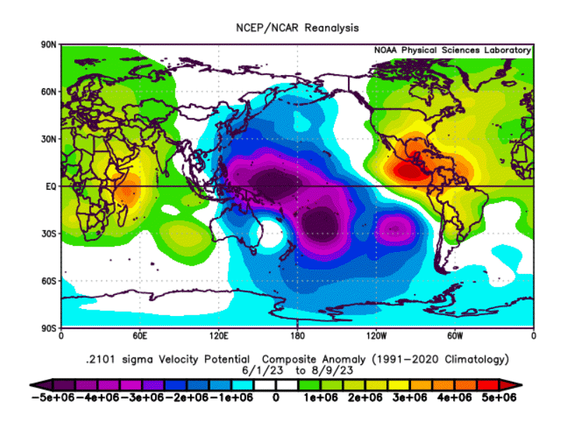
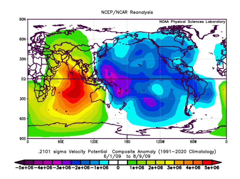
If we just look at where we are over the last 2 months (Jun 1 to Aug 9), the VP structure this year is more akin to 2009 than it is to 2015. Does that stay the same? Don't know, but my guess is that it heavily depends on the items mentioned in paragraph 1.
Note: You could even make the case that this year is west of 2009 when you look at the +VP subsidence regions being farther west in the Indian Ocean and Atlantic/South America.

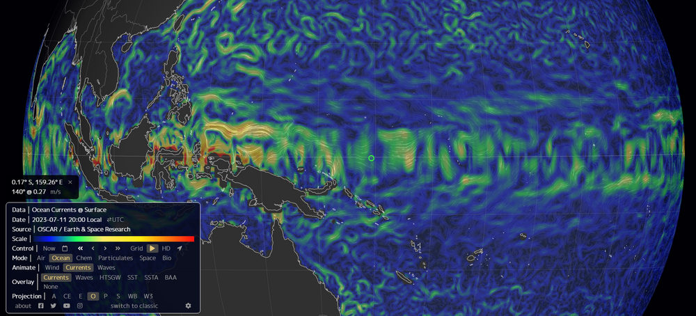
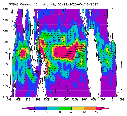
This makes sense so far -- as the warm pool there has not progressed nearly as far as '15 had at this point. It is on the move (finally), as per OSCAR and GODAS (Jul -> Aug). Though I suspect it will be in fits and starts since we're still getting periodic trade surges:
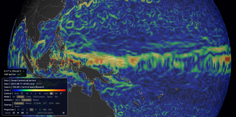
Compare to Jul:
And GODAS:
-
5
-
-
1 hour ago, tiger_deF said:
It's hard to take these bullish forecasts seriously when the Eastern Atlantic (which has been discussed as being a more favorable hotspot this season) is so, so dry.
For sure -- we're getting close to put-up-or-shut-up time. My lean this year has been at or below average. But it's the type of year where even one or two decent setups can yield some seriously convex risk.
-
9
-
-
19 hours ago, jconsor said:
The system near the Bahamas has maintained healthy outflow aloft and some mid-level spin on satellite for at least 24 hours, though convection has waxed and waned.
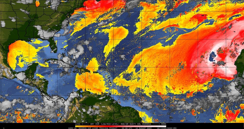
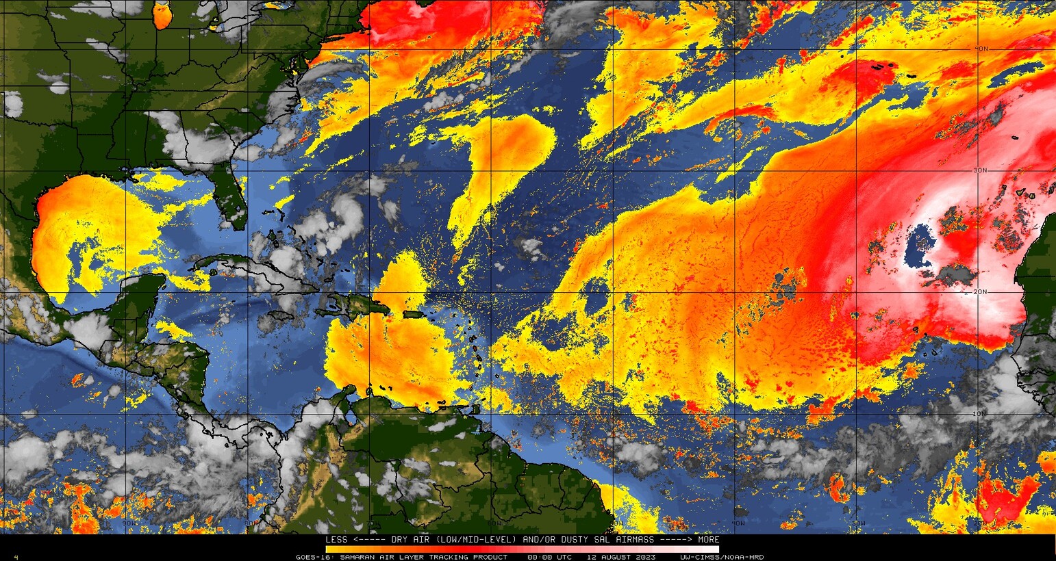
I wrote about the potential for this system (or a few others trailing it) to take advantage of favorable light shear in the Gulf of Mexico next week and possibly become "surprise" TCs.Genuinely hoping none of those pan out. The last thing we need is a TC making into the furnace that is current Gulf/Carrib. SSTs/OHC with low shear this year:

-
2
-
-
So far, this has been a *very different* evolution than we're used to for a Nino. It's done just fine surviving off of weak OKWs breaking near SA instead of further up the coast and tapping the NE Pac warm pool instead. Once the monsoon ends, we'll probably see the forcing being cited migrate east. The warm pool has already migrated to just west of the dateline and some significant TC-induced cooling has occurred near/north of the Maritime continent. I get the idea that we need strong WWBs and that's the classical analog take, but this one seems hellbent on using a route we haven't seen since the pre-satellite era.
If I were a snowbird at this point, I'd be rooting for a HHTH forcing-induced blocking over western NA and to help nudge the BoA low a bit further west of its standard Nino position or just amp the western ridge. Then maybe the supercharged STJ doesn't completely screw over the synoptic setup by flooding the CONUS with Pacific air.
Def seems like an easier lift than trying to bank on it heading to a more C-Pac based nino.
-
3
-
-
5 hours ago, GaWx said:
Please elaborate on the connection of CC and the terrible Maui fires. I'm asking because I posted a detailed write-up about the causes in the relevant tropical thread (with NWS sources cited) and didn't realize CC was assumed to be a contributing factor:
Might be relevant: https://journals.ametsoc.org/view/journals/clim/28/22/jcli-d-15-0006.1.xml
Paper's a bit dated now but conclusion still holds. Stronger drying from subsidence probably not helping.
And whaddya know:
Now, I'm sure there was some component of drying from mass deposition from the TC (as Andy points out in the comments), but it was very dry regardless.
Most publications will probably cite the stuff we hear all the time (increased SSTs, etc), but being as SSTs are regionally cooler than normal, that wasn't much of a factor here. Gonna say the downsloping helping mix down super dry air aloft was it.
-
2 hours ago, bdgwx said:
Martin Jucker of the Jucker et al. 2023 regional impact study of Hunga Tonga posted on twitter yesterday. Their global result...0.04 C of warming with a range of -0.05 to +0.11 C (1σ). That is 4 out of 4 studies that show 0.1 C or less warming. He does say his MiMA simulation which adjusts the SST shows 0.08 C of warming.
He does, however, reiterate that the biggest effects regionally will be in the northern hemisphere during the winter.
Yep, that's the kicker. The secondary knock-on effects in this case might end up being greater than a simplistic radiative forcing calculation would suggest. And the regional signal for an ensemble is surprisingly large. Large enough that it's a consideration when putting together seasonal forecasts for the next few years. Might -- for instance -- nudge the typical Nino winter/spring pattern of a BoA low further west a bit, blow out snow cover early and chain to more Greenland ridging in the summer. That scenario would certainly match a warmer Arctic and regionally cooler mid-lats and wouldn't shock me if a number of the ensemble members are sniffing out just such a teleconnection.
Also, ooof for West Coast rainfall and snowpack if that's correct.
-
2
-
-
Just got hit by that tail-end charlie cell. Strobing lightning. A few small hailstones but looks like the core thankfully went just south of the house.
-
Tail-end charlie storm just SW of Fredricksburg looking pretty beastly after that merger.
-
2
-
-
5 minutes ago, MN Transplant said:
The multiple bowing segments idea seems to be winning. The line in VA doesn't look very impressive on reflectivity, but there are still 60mph+ velocity readings just north of 66.
Yeah, that main bow probably going to steal the show and at the same time close off the (currently) most favorable area for supercells. Cells further south that can remain more discrete will have their shot as they get closer to the Bay.
-
1
-
-
Almost pristine airmass downstream off the Blue Ridge. Weak capping and 45-50kt of eff. shear. 30-33K delta theta-e between mixed layer and mid-levels. My typical cutoff for severe is 25K, but can be lower with this kind of shear.
The faster that cold pool develops and deepens, stronger it will get.
-
7
-
-
On 7/31/2023 at 10:17 AM, bdgwx said:
@wishcast_hater The 1970's was actually the period in which the consilience of evidence suggested that the GHG effect would dominate over the aerosol effect and that the planet would warm despite the ever increasing pollution. See Peterson et al. 2008 for details. In regards to the ice caps being gone I've never seen anything even remotely close to 10 years so that one is new to me. The ice cap melt out predictions have actually been getting more aggressive in recent years. But we're still looking at least a couple thousand years in the future. It's not even clear that 420 ppm of CO2 is enough to cause a complete melt out though it cannot be eliminated. Even the most wildly fantastic predictions supported by robust evidence that I have seen are > 1000 years. There is a massive amount of ice in the polar regions so its going to take awhile regardless. Even the Arctic sea ice isn't expect to go "practically ice-free" (< 1e6 km2) for a short period during the summer until around 2050. And that is with the newest and most aggressive prediction from the IPCC to date. See IPCC AR6 WGI SPM pg. 16 for details.
I wish you the best, but he isn't here to actually learn squat. He's here to post bullshit social media memes like they're science fact. The literal inverse of his username.
-
3
-
-
On 7/25/2023 at 10:24 PM, FPizz said:
Several years ago when the ice around Antarctica were at all times highs, and people said global warning is fake, the scholars said it all melts out anyway so the ice doesn't matter. Now that it's low, all of a sudden it's a problem. The message they send out doesn't mesh.
Citation definitely needed for this statement. Preferably anything peer-reviewed.
Conversely, where are all the deniers from '13-'15 that were crowing about record highs then? Crickets now. That's the kind of behavior that you'd expect from people that have zero conviction about their theory. They vanish or move the goalposts when the short-term data goes against them.
The constructive interference of internal variablity + wind stress changes + tropical forcing was always going to flip the other way at some point and if you knew what you were talking about, had conviction with the data to back it up and were willing to eat some humble pie in the short run, the prediction was always going to pan out in the longer-term.
-
3
-
 1
1
-
-
Actually, looking at GISS records vs moyhu's current temp change from June to July, the gap up for July annual could be similar or even slightly larger than the distance between (current) 1st place and 10th. Remarkable.
-
6 hours ago, chubbs said:
The last point is the July average to date. Continuing to get an unusually large SST rise in this nino.
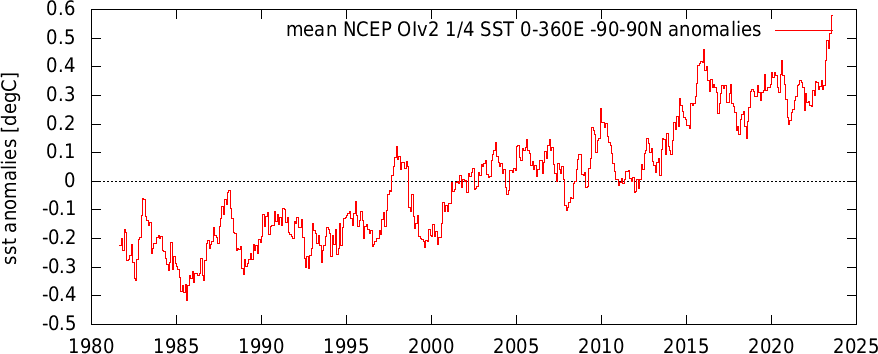
The gap-up coming for July is pretty surreal, esp. considering that ENSO effects are usually still seasonally muted at this point (image courtesy of moyhu):
-
1 minute ago, Bhs1975 said:
So if we drastically lowered emissions and irrigated and grew plants on as much available land as possible it would both provide a cooling effect and draw down huge amounts of CO2.
The "price" is higher dewpoints. CO2 drawdown isn't really a thing beyond the delta you'd get by increasing planting density, which is already very high. Converting it all back to forest would work to a degree, but we aren't going to do that.
-
14 minutes ago, forkyfork said:
would there be a cooling trend if we plotted theta e instead of temperature?
Nope. Well documented increase in mixing ratios/dews to go along with that trend.
It's a transient response almost by default since planting density is already very high and most of the land that can be farmed already is. Crank it a few more degrees and you set up a pretty vicious snap-back temp response once crops start having heat issues and the ET response is weakened.
-
2
-
-
1 hour ago, pazzo83 said:
I think if you took a period of record prior to the year 2000 and looked at Antarctic sea ice anomalies, you'd find they were approximately normally distributed. Of course perhaps now they aren't because there is rapid change going on.
Yep, and that's the problem. We don't know what the distribution necessarily looks like now and since the transient climate response is so rapid by the time you get enough data, it's already moved on.
Needless to say, paleoclimate doesn't have many nice things to say about where we're headed. This sort of "climate flickering" happened in periods of rapid change in the past as well.
-
3
-
-
4 hours ago, Bhs1975 said:
Persian gulf.
.Yep, lived there for a while. Wouldn't wish that malaise on anyone and a few hours of exposure can kill you. 40 minutes of that nearly put me in heat exhaustion once. Most outdoor work is done at night as a result. And - essentially -- they are reliant on air conditioning at times. One of my favorite tells to see if it was safe to go out during the bad times of the year (Jul-Sep) was to look out my window and see if any locals were walking around in traditional garb. If not, I stayed put.
They're adapted for it -- so the shit won't really hit the fan on this angle until we start seeing these kinds of conditions spread beyond the usual spots.
-
49 minutes ago, griteater said:
I certainly didn’t think this strong eastern warming would hang on like it has in the absence of robust westerly wind anomalies and warming arriving from the west
Weak OKWs breaking along the equatorial coast instead of more poleward certainly helping, as was the contribution from the EPac warm pool. Probably a mode that was more typical pre-satellite era, but we were used to the big WPac driven events. Perils of sample size, I suppose.
-
2
-
-
6 hours ago, bdgwx said:
It might be important to note that my predictions are based on GISTEMP lagging ENSO by 3 months. I know other analysis say it is 4-5 months and that is what I get for the satellite datasets, but my modeling hones in on 3 months for the surface datasets. I'm also using an equal weighting of the statistical and dynamic model averages from the IRI ensemble. That is [statistical_average] + [dynamic_average] / 2. I debated on whether to use the "Average, all Models" line in the table and decided against it since it weights the dynamic models more heavily because there are more of them. Based on what I've seen dynamic models are superior Jan-May (through the spring predictability barrier), but then statistical models have similar skill from June onward. For that reason I wanted to equally weight them. That may end up causing my global average temperatures to be conservative since statistical models basically say this ENSO cycle has peaked which seems unlikely.
One last thing...Hansen's monthly email came through today. He does not mince words. He says the warming rate has likely accelerated due to the extremely high Earth energy imbalance. If that is the case then that may contribute to me underestimating the global average temperature increase as well.

Good thing is that we're going to be able to test this prediction pretty soon. Agree that this year was like a coiled spring from a global temp standpoint. Key will be to see where that spring manages to jump to.
-
We're not yet to the point where we need to worry with WBTs. You need T/Tds of 100/85 or 115/80 type temps to hit dangerous levels (>31C WBTs) and 115/90 or thereabouts for true, hard habitability limits. 100/85 seems reachable in a few select areas for brief times, but Tds of near 90 don't seem possible yet.
-
19 minutes ago, Chicago Storm said:
Rapid decay of the derecho as it pushed through the IND/LMK/PAH CWA's. The heavily modified air from the morning MCS in E. IL/SW. IN/W. KY killed it off fairly quickly.
Looks like renewed development is underway across SE. Illinois, with quality still TBD. A staple off high end MCS events, thought.
Yeah, after this little batch of activity, I'd definitely be looking upstream to the outflow-reinforced front. Should be a really nice instability gradient and source of low level convergence for another MCS to come ripping east again tomorrow.


El Nino 2023-2024
in Weather Forecasting and Discussion
Posted
Trade wind burst pattern looks to resume after a month of relative slumber. Pretty telltale sign in the subsurface that a substantial OKW was generated. This one has more heft to it, so it may break further up the coastline.