

csnavywx
-
Posts
5,545 -
Joined
-
Last visited
Content Type
Profiles
Blogs
Forums
American Weather
Media Demo
Store
Gallery
Posts posted by csnavywx
-
-
If these changes carry over to the 12z runs, then I'll be on board. I want to see it survive a few initializations. Everything was slower on this run, and not just the main players. Could be running into the same issues again tomorrow -- and that matters when it comes to the NS wave being able to amplify instead of getting impinged on by the upstream NS kicker.
-
 5
5
-
 1
1
-
-
Just now, Solution Man said:
+450 for improvement
Good house line. I'd be betting against. That run last night had heavy Everest vibes.
-
1
-
-
Just now, alexderiemer said:
Do you still think our chances are decent?
Sent from my SM-G975U using Tapatalk
Yes, I like slider-type systems for this area. We're in better shape than we were even 24 hr ago. Just need the southern stream wave to phase, even partially will do it.
-
1
-
-
30 minutes ago, alexderiemer said:
Lots of goom and doom in the main thread. Still feel like we get a respectable event out of this either way
Sent from my SM-G975U using Tapatalk
To be expected after the Mt. Everest of Euro runs last night. There was nowhere to go but down from that one. That's why it's important not to bail all-in until more evidence accumulates. We're just not quite there yet and given the sensitivity of the positioning of the southern stream wave, it's probably not going to be all that clear until late tomorrow.
-
1
-
-
2 minutes ago, WinterWxLuvr said:
That’s what I thought but then I saw them showing up over flat areas of eastern MD all the way to the bay.
Yep, that wave train can go on for quite some distance after starting! The waves will duct inside the unstable/stable layer couplet until conditions change downstream. In this case, that's well offshore, even past where they can be seen via cloud condensation.
-
1
-
-
17 minutes ago, WinterWxLuvr said:
Since everyone is here, can anyone explain these ripples in the clouds. My first though was ridges but these ripples show up in places where there are no ridges
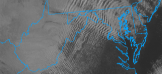
To be more specific -- this is being caused by perpendicular flow over a barrier (mountains in this case) and a stable layer overlying an unstable one. Note the dry adiabatic layer from the surface to about ~875mb and nearly isothermal/stable layer above that. Air is pushed upwards by the mountains, ascends and then begins to sink again as it enters the stable layer, causing it to accelerate downwards. It will then sink and accelerate upwards again after entering into the unstable layer. There's enough moisture in this layer today that some of it condenses out on the ascending portion of the wave.
It's a dead ringer for mountain wave turbulence and I use it all the time in turbulence forecasting.
-
5
-
8
-
-
Mega-weenie run, jfc.
-
4
-
 2
2
-
-
1 minute ago, stormtracker said:
SOLD!
This entire run is a giant tease, especially for my neck of the woods. I get the feeling this is Everest. Rips the sleet/mix line to within 15-20mi and then just stops and crushes. Can only go downhill from that one.
Would be thrilled with half that total, tbh.
-
2
-
-
Threat level gradually rising. Hoping it doesn't amplify *too* much at this point.
-
1
-
-
1 minute ago, Maestrobjwa said:
The heck is that??? Bam bam growing up to be a hobo?
Man, I'm aging myself. It's Captain Caveman.
-
5
-
-
Live look at the GFS:

-
1
-
 13
13
-
-
39 minutes ago, stormtracker said:
****!
No thanks. Way too far west for that, phase or not. Hard pass. I'll flip to bearish on a dime if that were to keep up. Luckily, looks isolated compared to the mean.
-
2
-
-
RGEM upstream kicker over the PNW is quicker this run, making the southern shortwave move a bit faster. Good run.
-
17
-
-
Feeling better about this Friday. Not quite there yet, but it's trending towards being a southern slider. Plenty of cold air around and if it comes in more amped/better timed, we cash in. If not, it's out to sea. But regardless, we don't end up with a slopfest or cold rain. All guidance trended better on the 00z. Another day of that and we'll be inside the D4 window and I'd be ready to get excited.
-
1
-
-
The general evolution towards a slider is great news. Certainly better than the enormous cutter with a wrapped WCB we were stuck with this time.
-
5
-
-
Flipped to sleet and then a bit of freezing rain about 40m ago now flipping to rain. Had about 90m of decent light-moderate snow. A bit more than I was expecting, but otherwise on track. Mix line blasting north pretty quick.
-
3
-
 1
1
-
-
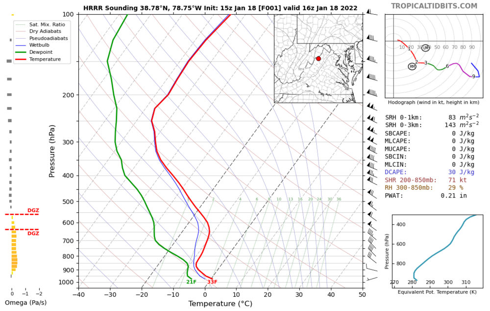
30 minutes ago, yoda said:
Pretty much isothermal but look at that DGZ zone... tasty

If it looks like that on the GFS w/ a lower vertical resolution-- I can almost guarantee it's already sleeting. 60+ knots in the warm layer. Once the diabatic cooling potential is gone from evaporation, that mix line is going to *fly* through.
-
2
-
2
-
-
1 minute ago, psuhoffman said:
The one trend that continues and its not what we want...is a slightly more amplified SW each run. That's what's offsetting a lot of the improvements people point out on some runs.
Yep, and goes negative too fast. We want a pitch that comes in farther east. This ain't it. Take the pennies you get and cut your losses on this one.
-
Name one system where that warm nose was over-forecast on something wrapped up like this.
I think this is going to be a bigger sleetfest than most are willing to accept atm. I'd be kind of surprised if DC gets any more than ~3-4 hours of snow out of it before pingers mix in. That elevated warm nose/WCB is going to kill totals east of the mountains.
-
4
-
3
-
3
-
-
1 minute ago, snowfan said:
Someone in southern Md, the northern neck, etc should be ripping tomorrow morning.

I'd definitely take that. One theme has been intense banding showing up. But ofc, if there's intense mesoscale lift, there will be mesoscale subsidence nearby.
-
1
-
-
- Ground temps are warm.
- Boundary layer starts warm.
- Heaviest amounts are likely to be in intense mesoscale bands. Great if you're in it, but that means somebody is getting shafted with subsidence.
- SLRs will be very low to start. They improve as time goes on, but we're looking at an 7-9:1 maybe improving to 10:1 by the end.
- Sneaky southerly flow at ~700mb might be just warm enough to mix sleet on the southern end as the closed low opens up.
- Track very sensitive to small changes. Luckily we're inside 24 hours, so only minor shifts are likely going forward.
+ Perfect track. Southern slider off Hatteras-east of ORF with a closed (!) low that doesn't track up the coast.
+ Related to first, but no significant WAA belt to mix (except perhaps very high up >700mb). Column temps cool through the storm.
+ Very high moisture availability. 1"+ QPF/6 hours. Incidentally, while models tend to overdo QPF <0.75"/6 hr, the opposite is true for values bigger than that.
+ DGZ and max lift overlap for a good while. Combined with near iso-thermal layer (-2 to -8c) below, this will probably result in a ton of big rimed dendritic and mixed aggregates. Fat flakes that can pile up fast.
+ Near min sun angle and high boundary layer winds will limit the effect of the Bay. Still expect shoreline accumulation to be lower, but not as bad as with low-gradient situations.
+ Low static stability, moist neutral to even slightly unstable (wrt theta-e) in mid-levels favors some convectively-enhanced mesoscale banding. Good deformation zone too. Bands will be intense, which is good, because we need high rates to overcome thermal issues initially.
Right now, thinking max band runs from Mechanicsville to Easton/Cambridge. 6-12" of wet concrete.
-
2
-
1
-
-
Busting out BUFKIT on this morning's guidance has been eye-opening. More to come in a bit....
-
1
-
1
-
-
1 hour ago, Wxdavis5784 said:
This aged well! This storm has me wishing I was back home in SOMD!
best of luck guys!Thank you for your sacrifice, sir. We will relish every flake.
-
1
-
-
29 minutes ago, Typhoon Tip said:
I've often wondered how sci fi it really is to speculated a mega displacement event - no sense describing what is meant by THAT.
Little known ... I read or heard a story someplace - the age old cry of the rumor mill LOL, admittedly - where climate stations owned by different sovereign origins, situated out over the expanse of the Greenland ice cap - but as typically the case, are in comm's relationships with one another pretty regularly ... - all experienced an "Ice quake." Ice quakes are not altogether that unusual, in and of themselves, but having them all experience the same description, at the same span of minutes, within the same hour, stationed 20 or 30 nautical miles apart, is either an extraordinary act of coincidence at massive scales, ...or something else was taking place.
Later that day, they started failing direction finding tech, because their coordinates were all off. Tapping devices, giving shakes ..maybe the batts are low..etc. Turned out, all three stations ... including the ice they were anchored upon, up and slid some 1/4 to 1/3 of a mi. But being situated out over the open expanse, where by there is nothing to differentiate against any horizon fixtures, they were unaware this was happening, the were actually, en masse, in motion. Other than the rumble and shaking going on as they moved.
This was later attributed to increase basal flow rates lifting and "lubricating" the glacial foundation, and it lost anchor footing temporarily and away she went. It stopped... obviously.
But this business with the "Dooms Day Glacier," as the press has come to denote, kinda hearkens to a similar scenario. I haven't dug in - just on the surface so far... Only here, the water ice that was essentially holding the land -based ice, has always preventing that.
All the recent calving events having taken toll of the interstitial integrity of the mass "damming", ... maybe something like a catastrophic displacement nears a threshold. And the one that 'rumored' to have begun and halted one fateful day in mid summer over the vast expanse of Greenland, could take place. Only in the case of Thwaites, it doesn't halt.
I think that fear must be implicit in this, already.
The eyewitness accounts from Larsen A when it disintegrated were pretty eye opening. It went fast, as did B. C is looking a bit less healthy nowadays.
As for Thwaites, losing that shelf in the next decade would set up some pretty bad news for mid-century. There's not much to keep that mass from moving at an increasingly faster clip once the plug is degraded.
-
2
-


Southern MD / Lower Eastern Shore weather discussion
in Mid Atlantic
Posted
Still not dead yet. Though it looks like LS over in Salisbury has a better chance than the rest of us on Fri night into Saturday. Front is slower than originally forecast and I expect the northern edge of the precip shield to clip us. The northern cutoff between virga and accumulating snow will be sharp. You will either be in it or not, generally speaking. Not the big storm I'm sure everybody was rooting for earlier this week, but never take your eye off a southern slider. They can sometimes bite at the last second.