

csnavywx
-
Posts
5,543 -
Joined
-
Last visited
Content Type
Profiles
Blogs
Forums
American Weather
Media Demo
Store
Gallery
Posts posted by csnavywx
-
-
26GW of the 34GW shortfall was from natural gas. Even Governor Abbott mentioned this on all the local stations he was brought on to interview with. Despite the frozen turbines, the wind shortfall was much less, around 1-2GW.
-
 4
4
-
-
1 hour ago, PrinceFrederickWx said:
Southern Calvert and St. Mary’s seemed to get a lot more ice than central Calvert. Driving down 2-4 to California early this morning looked like a forest of glass. Lots of downed tree branches- I can see why there were power outages.
Yeah, it was almost pure freezing rain down here and very dependent on wet-bulbing effects due to borderline temps. Tree tops and anything exposed is absolutely loaded with ice and anything close to the ground only has a glaze. Not uncommon to see near-surface objects have only a tenth of an inch but have half an inch of accretion several feet up. Shave off a degree on this storm and it would have been a disaster here.
That being said, it was a very pretty drive in today with the overnight hoarfrost that grew on the ice.
-
1
-
-
30 minutes ago, howrdcounty snow said:
very good read
Friday Funny: nature makes a mockery of month-ahead model forecasts.
Please do not post this without cross-checking its sources. While short-range climate forecasts possess lower (but positive!) skill, trying to equivocate these with GCMs is a faulty argument on several levels and requires a rebutting that would derail this thread.
-
4
-
 1
1
-
 2
2
-
 1
1
-
-
39 minutes ago, PrinceFrederickWx said:
Power outages look bad in St. Mary's. It's flickered here a few times but I've never fully lost power.
11% in St. Mary's and 8% in Calvert so far. Starting to lose small limbs regularly. Have heard a few bigger ones in the woods.
-
Got above freezing for a few hours this afternoon, but now back below with a moderate freezing drizzle. Tonight and tomorrow might get nasty with wave 2 in SoMd.
-
1
-
-
3 minutes ago, pazzo83 said:
meanwhile DC struggles to get below 30F.
I've been happy to be getting scraps down here after 2 shut-out years. Last year I had to scrape frost off my car a grand total of twice.
-
8 minutes ago, pazzo83 said:
lmao south TX is going to get more snow than DC this year (and definitely going to record a colder temp).
+TSSN at 14F in south TX definitely takes the cake.
-
1
-
-
13 minutes ago, Hoosier said:
Snowing a little better than I thought it would be under these light radar returns.
Doesn't take much with a profile like that.
-
1
-
-
32 minutes ago, Stebo said:
Currents for southern Texas are just out of this world
That's some truly extreme stuff. Skew-Ts/forecast profiles are absolutely nutty looking.
-
Just now, Chicago Storm said:
18z GFS bumped NW, and para GFS tick NW.
Good convergence and all now well NW of last night's 00Z runs.
-
3
-
-
It makes sense from an operational standpoint to protect your low end at this point until more guidance picks up the trend towards a more negatively tilted mid/upper trough, especially since an error of even 0.1 to 0.2 of liquid with 20-30:1 SLRs can result in a pretty sizeable bust. But I will say that the NAM has been absolutely killing it on the east coast at these ranges, beating even the Euro/UK (with the typical caveat about using high-res CAMs cautiously for some winter events). The GFS (and the new version as well) has been trending that way the past few runs as well, so keep a sharp eye out. It wouldn't really surprise me to see some convergence on that solution in the next 12-18 hours.
-
4
-
-
1 minute ago, Thundersnow12 said:
Haven’t seen this guy in a hot minute
Busy getting shut-out of winter storms in southern Maryland nowadays, or iced (like yesterday), but this one caught my eye. Arctic powder bombs are fun and challenging to forecast.
-
4
-
-
1 hour ago, Chicago Storm said:
low-ball still.
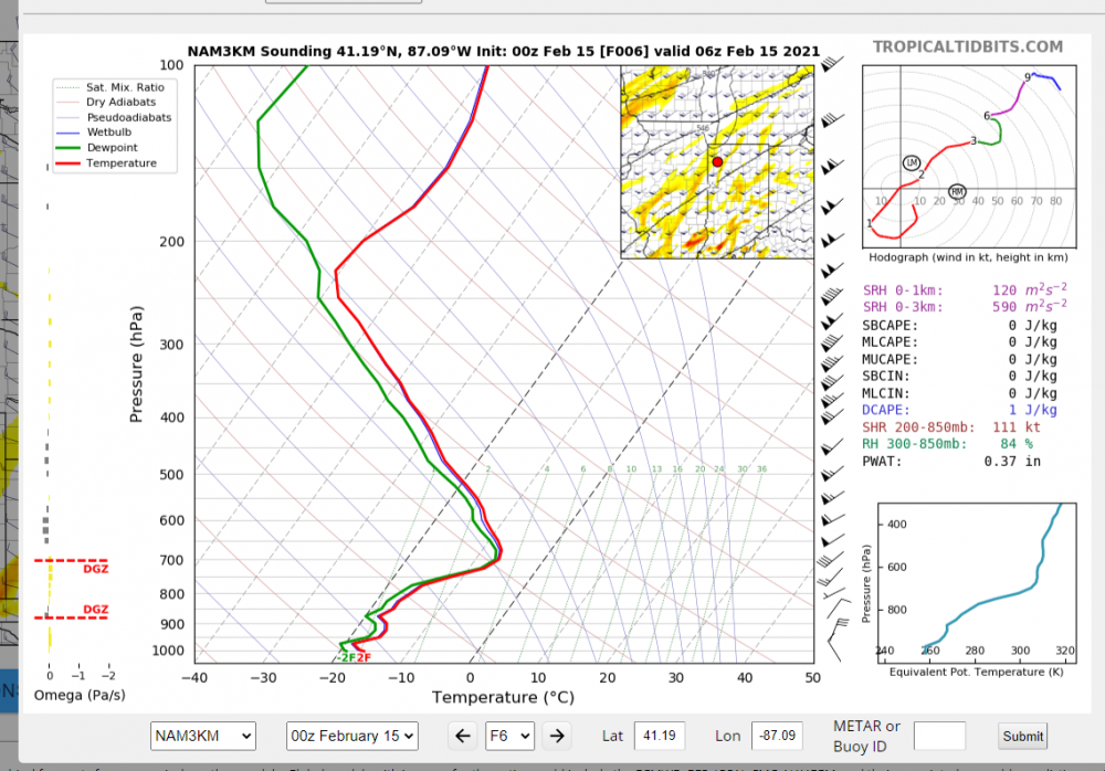
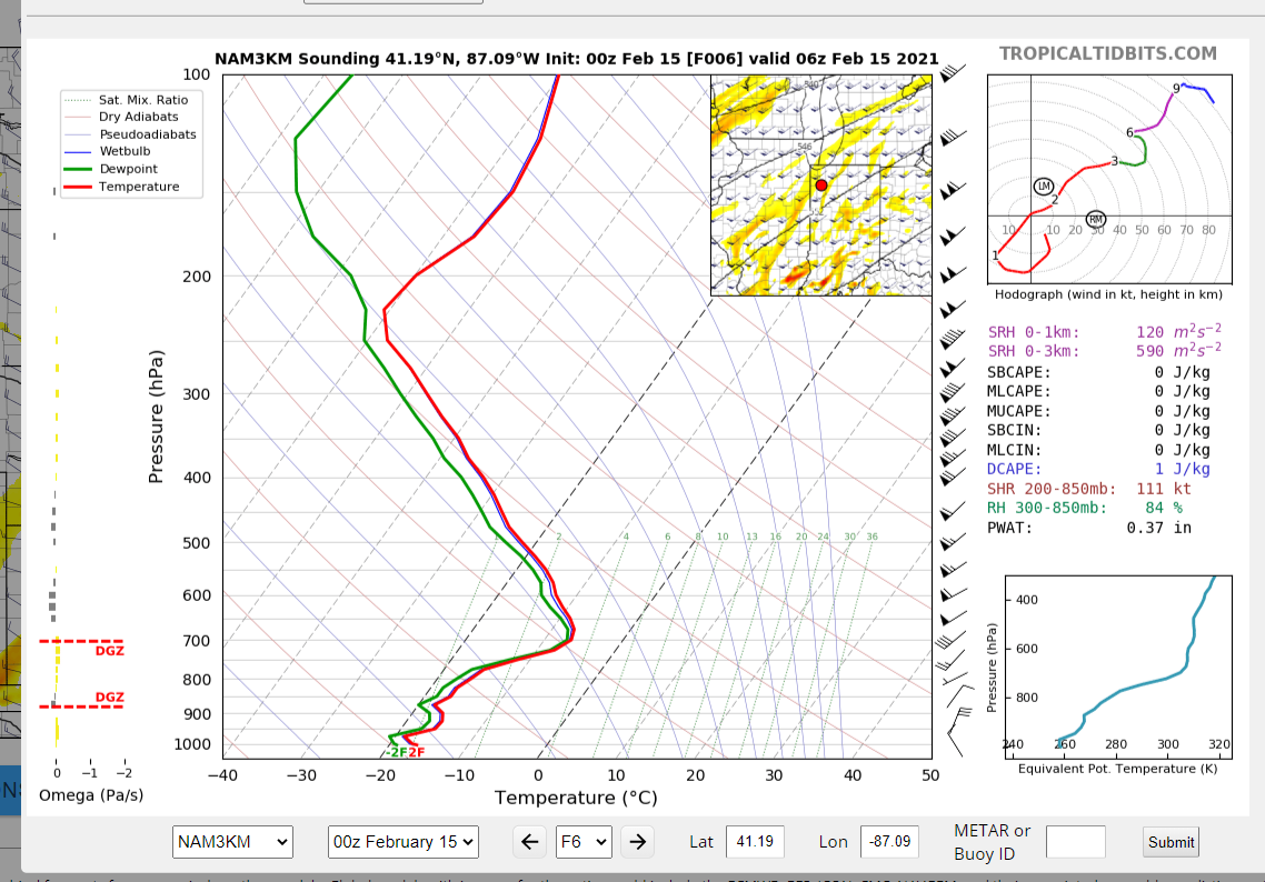
Not sure if it's being mentioned much, but that's a hell of a DGZ to work with. Ratios are going to be sky-high on a broad swath of N/NW flank of the storm. DGZs are between 200-400mb in depth and wind shear is low, which would cut down on shattering/breaking aggregates. Saturation isn't great, but it's not bad, either. Pretty telling when the pos-snow depth change products on the models are significantly higher than the classic 10:1 maps. You don't often see that kind of delta.
-
5
-
 1
1
-
-
49 minutes ago, MN Transplant said:
Just took a walk with the dog. Sidewalks greasy but not slippery, if that distinction makes sense. There is a glaze on all elevated surfaces, but nothing significant. Maybe 1/8”. This would have been a big deal if it happened overnight.
29.2
This 100%. Snowcover helped, but transpose this forward 6-9 hours and throw in some slightly lower ground temps and it would be way worse. It's very close as it is, but accretion efficiency wasn't quite there for a big dog ice storm.
-
1
-
-
Yep, weak insolation keeping this from becoming an absolute disaster here. 30.5/27.5. Lower dews will be a big concern heading towards sundown considering the steady 10-13 knots of wind.
-
2
-
-
Tomorrow morning starting to look pretty nasty. Not liking the faster dewpoint drop this morning and the mid-levels get saturated again a lot faster on the latest NAM and HRRR tomorrow morning. May prove to be tough to get rid of that near-surface cold wedge. If tomorrow starts out as sleet or a sleet/fzra mix, that'll be a bad sign.
-
3
-
-
14 hours ago, kgottwald said:
Or a Yellowstone supervolcano eruption.
I wonder what the climate around here was like in 20,000 BC when the glaciers reached to Central PA.
About -20C avg temp in DC in Jan. 100-150mm of liquid equivalent on average. So 3-4". Big powder bombs are a weekly event with that kind of persistent tendency for jet split. Only issue? It never really gets that warm in the summer. Maybe 40s and 50s in July on average.
-
3
-
1
-
-
Solid moderate snow for a while. About 2.5" so far. Will probably end up somewhere between 3 and 4". Not too shabby.
-
1
-
-
About 2.5" so far, moderate accumulating snow currently. Decent rates.
-
4
-
-
1 hour ago, H2O said:
trend, yo. soon it will be 0.1" to tumbleweeds. frozen ones
If people keep complaining, it will be 33 and tumbleweeds -- just out of spite.
-
1
-
2
-
-
The NAM folding to the Euro past tau 48 is literally the least surprising development ever.
-
13
-
7
-
-
Both the 00 and 12z Euro runs are weenie-of-the-year material for this region. Usually the Euro doesn't flinch at this lead time, so it will be interesting to see if the other guidance comes into agreement with it over the next 12-24 hours.
The setup is pretty good for us. Nearly stalled boundary, with waves riding up to provide decent bouts of isentropic upglide, slowly sinking airmass with a strong high that doesn't move off prior to the event and can feed in cold, dry air near the surface and help provide f-gen forcing aloft. Lots to like -- question is whether we'll be just cold enough for the first wave or not.
-
3
-
-
49 minutes ago, alexderiemer said:
I'm just hoping for snow that actually stays on the ground. We got nothing left from yesterday.
Sent from my SM-G975U using Tapatalk
Nature of the beast with these super-marginal events. Really need a big arctic high to tap into to prevent that from happening.
I was thinking about 2" yesterday and we ended up with slightly more than that, so can't complain too much.
-
1
-
-
Hope everybody enjoyed the paste job yesterday. We did respectably well. Usually do with sliders. Another shot here on Wednesday night and then again on Friday. Perhaps another after that if that big honking Arctic airmass presses down slowly, though there might be some legit mix with an airmass that shallow.
-
2
-
Monday Morning 2/22 Snow Event
in Mid Atlantic
Posted
Expansion of echoes over the last two hours was way more aggressive than I was expecting and I even brought precip in earlier than guidance on my forecast because WAA events usually do that. Looks like a combo of strong DPVA, WAA and jet forcing are doing some serious work this morning.