

csnavywx
-
Posts
5,543 -
Joined
-
Last visited
Content Type
Profiles
Blogs
Forums
American Weather
Media Demo
Store
Gallery
Posts posted by csnavywx
-
-
9 hours ago, pazzo83 said:
DCA hit 80F again. Endless summer continues.
If you believe the CFS weeklies and NMME monthlies, there's a lot more where that came from. Very little snowcover build over NA this month and our source region for cold air remains quite warm, so even the cooldowns will be more of a reversion closer to the mean rather than any significant negative departures.
-
 2
2
-
-
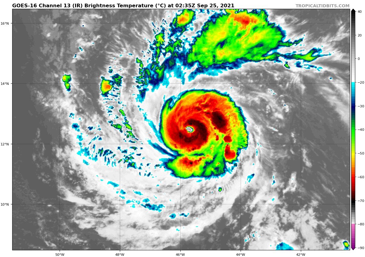
It's just you. Plenty of banding still around 80% of the core.
Annulars generally require marginal SSTs and light east-southeast shear to offset beta shear. That helps strip banding and forces the vortex upright.
-
 4
4
-
 1
1
-
-
Top-heavy nature of the CAPE tomorrow and low-level capping means updrafts might initially struggle in a relatively anemic cumulus field, but once the cap weakens sufficiently, it should take off pretty quickly. Little warm-sector cloudiness to speak of (other than a bit of acu or accas). Abnormally large proportion of the instability is above the freezing level (for these parts). Coming up with 0.5-0.75" on the hail forecasting diagram, though could easily breach 1" with some assist from mid-level rotation in individual cells. Gusts likely to be 35-45kt widespread, especially if a small LEWP or two gets started. Lightning might end up being some of the best and most intense of the season for some areas, especially closer to the Bay.
-
14 minutes ago, tiger_deF said:
Sam's really been shedding the bands. Do we think this is just a temporary pulse down or maybe the beginning of some kind of annular transition?

No, annular hurricanes generally require marginal SSTs and light southeasterly shear. Sam has neither nor is expected to have either.
-
2
-
-
On 9/11/2021 at 8:49 PM, OSUmetstud said:
The winds here were probably like a 1 in 10 to 20 year event. We gusted to 85 knots in a March 2017 low that was 952mb or so and came up the same bay as Larry and that was strongest wind gust here in 40 years. It's the second highest gust for a TC here on record behind Ione in 1955. Far more damage than the March 2017 windstorm though. Probably second behind our snowmaggeden super blizzard in Jan 2019 in terms of anomaly and overall impact.
Wow, that's pretty gnarly then. Wasn't immediately obvious that it was going to be quite that bad up there -- but the radar structure on landfall was still pretty tropical in appearance with a partially intact eyewall.
-
1
-
-
7 hours ago, OSUmetstud said:
The surge on Placentia Bay (about 5 ft or so above high tide) might be one of the most impressive aspects of Larry.
How was it up there -- as compared to say a strong mid-winter cyclone?
-
Just now, MN Transplant said:
Did we lose the anemometer at MSY?
After looking at the METAR list, it sure looks like it.
-
I see the MSY wind sensor got knocked out. Ugh, not great.
-
Starting to get real in NOLA:
METAR: KMSY 292240Z AUTO 09054G72KT 1/4SM +RA OVC012 25/ A2905 RMK AO2 PK WND 08076/2208 LTG DSNT S PRESFR P0023 T0250 RVRNO $
-
3
-
-
The breakdown of the vortex rossby waves in the eyewall over the past 30 minutes is like something out of a textbook. Also waves propagating out from the center into the rainbands (obvious from radar loop).
-
7
-
-
Yeah, I was premature on the bank call. Either wobbling or getting some frictional torqueing as it interacts with the coastal interface -- but whatever it is, we'll take it.
-
Yeah, cam is tilted now, but somehow still up.
-
Can't be sure yet -- but she looks to be banking slightly right relative to earlier. Might be the start of the turn.
-
1
-
-
Saw that cooler and other trash.
Sherriff of Grand Isle on the phone on TWC said their sensor reached 148mph (prob a gust) before breaking.
-
1
-
1
-
-
3 minutes ago, purduewx80 said:
That is most definitely not how you read that. It's the altimeter, which was 29.22" or around 989.5mb. Looks like he deleted both tweets fortunately.
That's what I thought too -- but he clipped the GIF version instead of the flash version of ADDS, which indeed uses whole integer numbers for SLP (the flash version uses the tenths, like in METARs). Still, the lowest I can find from the station's METAR record is:
KCYD 291035Z AUTO 1/4SM -RA FG OVC004 27/26 A2809 RMK A02 P0002 T02710260
Which is about 951mb. The issue is that the station didn't report an altimeter for 90m prior to that and it was on the way up -- so we don't really know.
-
1
-
-
10 minutes ago, Eskimo Joe said:
Was wondering why there was so little precip on the NW side then saw this thread. Wonder if this will impact rainfall forecasts inland?
Shear vector is out of the WNW. Only around 8-12kt, but that's enough to place more of the precip on the E/SE side of the circulation.
-
1 minute ago, OSUmetstud said:
I think that's fairly normal in the strongest, right? The flight level winds and surface winds are close with the big max in between.
At least some of them from my recollection, yeah. I recall reading some papers on those two in particular and how normal FL wind reduction to the surface wasn't always appropriate.
-
Acting like Dean and Mitch with these wind profiles. Max warm core strength closer to the surface.
-
1 minute ago, mempho said:
They said "little to no storm surge flooding expected" and that forecast was based on rapid intensification.
Sent from my SM-G950U using Tapatalk
Yes, it was. Around 105-115 max intensity. We're going to clear that in terms of max w and radii, which will have an impact on those initial numbers. The levees will likely hold, which is why I said "risk". Additional strengthening will not help though and the increase in risk is not linear.
-
1 minute ago, WinterWolf said:
Of course…but this is gonna be SUBSTANTIALLY STRONGER which wherever that NE Quadrant comes in will just scour what towns are there…this is gonna be worse.
Every storm in this rarified air is different. Katrina's surge will be hard to beat due to its gaping maw and cat 5 intensity well before landfall, which allowed a significant swell and surge to build before it made landfall (it weakened only very shortly before landfall). Ida has had less time, even though it will be stronger in terms of max wind. I suspect the wind damage will be the standout with this one -- though the surge on any cat4/cat5 is no slouch either.
-
9
-
-
Really beginning to think that Nora screwed the pooch. The push from differential shear on Fri-Sat morn plus the outflow push from Nora into the TUTT over the western GOM has really left this in a bad spot. We need a lucky break now.
-
8
-
-
I was expecting stronger when I got up this morning, but this is definitely over my guess. We need an EWRC and fast. Main hurricane levees are at risk at this level. Any more strengthening will not help in that regard.
-
5
-
-
T-numbers shooting up: 5.6 current, 6.1 raw; Satcon showing major (100) with hourly up to 105kt.
-
1
-
-
Pretty obvious strengthening ongoing atm with the storm crossing a warm eddy (as part of the Loop Current). Eye looking to try and clear out with a more classic look likely soon, given deep convection has wrapped around the center.
Global Temperature 2021
in Climate Change
Posted
Blizz posts are usually a good, contrarian indicator and a solid sign we've hit bottom on a short-term trend.