

csnavywx
-
Posts
5,543 -
Joined
-
Last visited
Content Type
Profiles
Blogs
Forums
American Weather
Media Demo
Store
Gallery
Posts posted by csnavywx
-
-
Front end might get started earlier than expected. Quite a bit of lift progged with some f-gen and upglide pretty high in the column as early as midnight to 3am Sunday.

-
 2
2
-
-
8 minutes ago, stormtracker said:
This is the primary Im talking about
Just an artifact of how the model stamps out the lowest pressure even though that's not where the CoC is. That "low" is being printed there likely because of terrain effects and the fact that the primary over the OH/IN/KY border is filling pretty quickly at that point, causing the pressure at the old CoC to be higher.
-
3
-
 3
3
-
-
Transfer is definitely a little faster on this run. Primary a touch weaker and further S to start with.
-
3
-
-
12z runs have been a stepwise improvement so far. We definitely need the southern/suppressed trend to cash in on any backside stuff. While the Euro is kinda out on its own, it's a deadly model to bet against.
-
3
-
-
Will be spinning up some BUFKIT and digging in tomorrow on this, but that front end f-gen and WAA driven snow looks like it could actually produce some decent totals. Not sold on the back-end stuff. That's far more tenuous unless (again) the suppressed solution wins out.
-
2
-
1
-
-
Next week looks like a sloppy gyre of disappointment. Some light stuff possible around the slow-moving upper low or perhaps in association with the clipper-type shortwaves that drop in, but don't count on it. Thermals are just anemic for January. Not much quality cold air around to tap into over Canada either.
-
3
-
 1
1
-
-
3 minutes ago, psuhoffman said:
Yes but compare it to previous runs it was getting there. I don’t think there is much chance it goes negative given the flow in the Atlantic but we need it to close off sooner. It happens a little too late this run but way way closer.
Hard not to be happy with that run. Way better than 00Z and trending the right way.
-
7
-
-
6 minutes ago, MN Transplant said:
I know I’m late to this as we wait in the euro, but that precip shield, that wind direction, that low location, the date, and then you drop that it is 37/36 at DCA. Unreal.
It is -- though drawing this up through BUFKIT reveals that the freezing level is down to 1700' by this point with just 25 J/kg of positive energy left. Definitely some BL issues on the front side, but not insurmountable.
-
1
-
-
9 minutes ago, WxUSAF said:
Hopefully we can meet in the middle of where the GFS and Euro were yesterday, which gives the whole area a respectable all-snow event.
Even the coastal areas can get in on the action with a low that pulls away as it starts to occlude rather than tracking up the coast. Allows the BL above the near-surface layer to cool off and let diabatic cooling do its work. Sun angle not an issue right now either (unlike a March setup).
-
5
-
-
UKMET has a storm now. Much closer to the GFS/Para/GEM camps. Still a fragile setup ofc, but marked improvement.
The GEM being weaker shouldn't be surprising considering how amped and NW it was compared to its own ensembles last night.
-
7
-
1
-
-
2 minutes ago, psuhoffman said:
True...but those factors can often time lead to there being a very heavy banding along the northern fringe as the lift meets the resistance in the flow. Globals often miss that and its why a lot of times you get a "shift north" at the last minute. The storm didnt actually shift north the models simply didnt see that feature.
No doubt there can be some intense banding with the type of explosive non-linear cyclogenesis this setup can produce, just warning in advance of the (likely sharp) cutoff. You're either in it or you're not type deal. One thing to watch in the globals is where the sloped f-gen zone intersects the DGZ or maxima higher in the column that can overwhelm dry layers. Sometimes, in the scenario you reference, a good indicator of misplaced banding can be teased out of looking at cross sections. We're a few days away from being able to talk about that realistically, but something to look for.
-
6
-
-
One thing to keep in mind is that given the compact nature of the shortwave being progged and the (very) large and dominant ridging to the north with a pretty hefty windfield, I would bet on a sharper northern cutoff with less of a taper. This system is less likely to feature big mixing zones and the more gradual taper-off you get with a big wrapped WCB-type configuration. Sharp R/S and S/nothing lines.
-
3
-
-
Mixed rain to snow showers possible tomorrow afternoon and early evening in tandem with the large upper low and attendant vort max. Skies will be mostly clear in the morning, allowing for some insolation under steady mid-level CAA. Should be just enough instability to kick them off. Might be a lightning strike or two with the stronger cores.
-
2
-
-
If we're going to cash in on a SSW-induced blocking pattern, it's usually a month after the event. Still a ways to go in that regard. Long range starting to show the flip to cold. But of course, we will need the southern sliders to continue.
-
2
-
-
5 minutes ago, high risk said:
I'm struggling to understand the severe warning, as while that's an impressive feature on radar, it shouldn't be surface-based and therefore unable to get the winds to the ground. But I'm prepared to be wrong....
Might be issuing on the condition that downdrafts are able to tap and bring some of the momentum from that ramping LLJ to the ground. Haven't seen any ground reports that suggest that's happening right now though. My gust spreads here have been large even in the absence of precip so far -- so it seems possible.
-
Still looking decent for some snow showers tomorrow for S MD and the eastern shore. Eastern shore might even fare a bit better due to some downstream Bay enhancement. 700mb temps drop wayyyy off to around -20C tomorrow with bay temps still running around 8C. Despite not particularly favorable wind fetch angles (except down the Potomac), could still see some enhancement of snow shower activity.
-
3
-
-
Still leaning strongly towards most of the best action being with narrow convective band along the front with the intense linear forcing and weak instability and then the snow showers ahead of the big mid-level vort during the day tomorrow. Post-frontal stuff will probably get shut down early by that enormous mid-level dry slot. It nearly always underperforms. The saving grace here is intense mid-level CAA ( <-20C temps at 700mb ) and good DPVA which allows for a great environment for snow showers. The tropopause height legit drops to 700mb with surface temps near freezing. Hard to find a much better environment for nice little mini-blizzard-like snow showers east of the mountains.
-
4
-
-
3 minutes ago, WxUSAF said:
Euro was really close D8-9. Has this weird frontal timing so it's rain for everyone, but just need to time the cold air a little more like the GFS or GGEM. Lots of chances post-Xmas.
EPS looked better timing-wise, so that's encouraging at least.
-
3
-
-
11 hours ago, Prestige Worldwide said:
Accumulating snow possible for us on Christmas? Oh yes- let’s bring this one home crew!
It's possible. Wouldn't count on the post-frontal stuff on X-mas eve. Those typically underperform unless the setup is just right. However, there does seem to be a window on Xmas day proper with the big mid-level vort and very steep low-to-mid level lapse rates. Would be a snow shower type setup with 850mb temps around -15C.
-
1
-
-
Regardless of the post-frontal stuff (which I find it hard to get excited about -- post-frontal setups rarely produce much), those soundings and the position of the cold pool aloft look somewhat favorable for snow showers on Christmas Day proper. Very cold temps aloft. Might be enough weak surface-based instability to kick off some popcorn snow showers ahead of the mid-level vort.
-
4
-
-
Warm nose aloft making steady progress. Should be a pretty wide area of sleet for a while -- freezing rain where the nose gets thick enough. Haven't seen any thunder reports yet, though.
-
1
-
1
-
-
4 minutes ago, PivotPoint said:
Can @psuhoffman explain this sounding. This is the back edge. Do we lose lift here? Looks like there’s no snow growth...
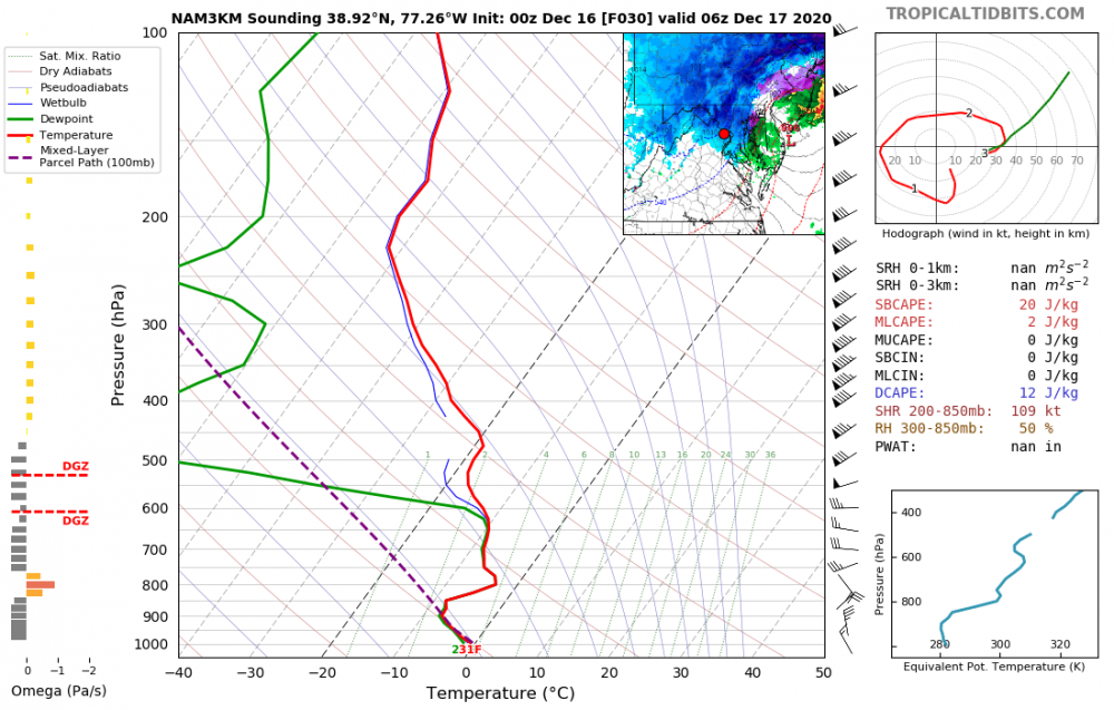
That's still snow, but not particularly efficient. Saturation cutoff is around -10C.
-
1
-
1
-
-
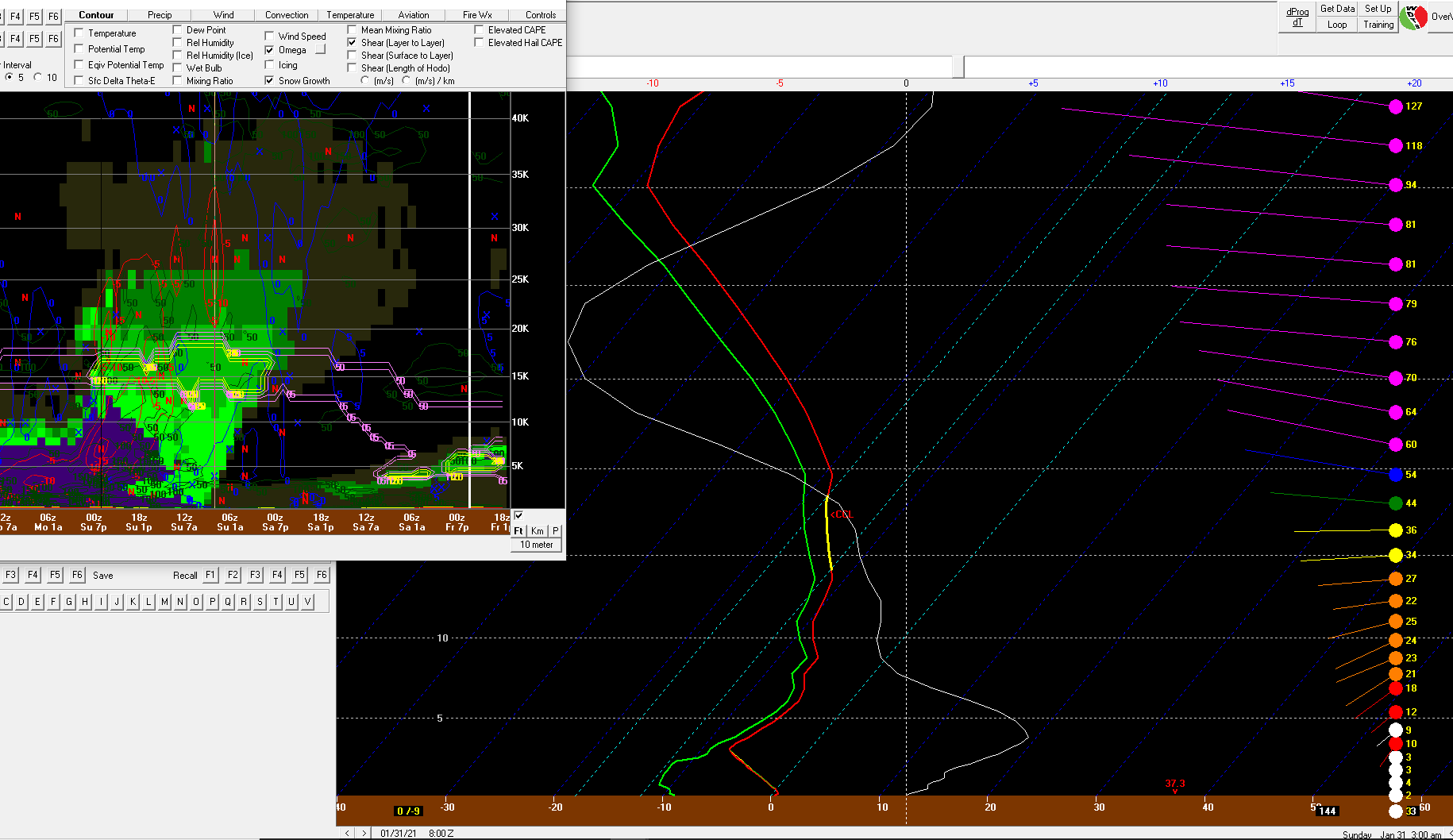
There's going to be a LOT of sleet with a warm nose/WCB of that strength. May also be some embedded thunder with those soundings showing a narrow ribbon of conditional upright instability getting entrained aloft.
-
8
-
-
1 hour ago, jbenedet said:
Kinda surprised no one has dropped the “Harvey” analog yet..
I haven’t looked into it but I believe Harvey also occurred during a significant -NAO, which seems we will likely have this time as well.
The amount of spread in the ensembles even 24-48hr out is pretty amazing. That said, if this thing manages to stay offshore after the westward turn, it'll have a favorable period for intensification. Oh, where have we heard that one before?
-
1
-

Southern MD / Lower Eastern Shore weather discussion
in Mid Atlantic
Posted
That early morning stuff should be higher-ratio powder and lay down a decent coating (as well as saturate the column) before the main WAA shield arrives later in the morning.