

MN Transplant
-
Posts
17,834 -
Joined
-
Last visited
Content Type
Profiles
Blogs
Forums
American Weather
Media Demo
Store
Gallery
Everything posted by MN Transplant
-
That was barely football today. A win is a win, but woof.
-
That's...not how global temps are calculated.
-
Wettest Three Consecutive Years in DC History
MN Transplant replied to RodneyS's topic in Mid Atlantic
This is pretty amazing. -
EF4 slipped just to my south. Bust.
-
I edited the post, but it looks mostly dependent on rates. It was right in the middle of that line. My elevation could have maybe helped. 37.0
-
Ha, it’s snowing. Good stuff. Edit - maybe lasted 2-3 min in the middle of the line. As soon as it lightened up it flipped back to rain. Rates!
-
What a cluster of a game. They played well outside the 2 defensive TDs allowed IN 10 SECONDS. Kirk started the year rough but he is on fire now.
-
1.11”
-
I don’t even bother “winterizing” my mower. I mow to mulch up leaves in December and February most years.
-
My wife makes a Thai basil chicken that is so much better the second time around when the heat really gets into everything.
-
Mid-Atlantic winter 2020-21 snowfall contest
MN Transplant replied to AnEndlessMaze's topic in Mid Atlantic
BWI: 12.1 DCA: 9.8 IAD: 14.5 RIC: 8.1 Tiebreaker (SBY): 5.1 -
I don’t post in the LR thread because I have no idea about what I am talking about, but this is...something
-
The 0.04” overnight was the only measurable precip here in November outside the dousing around the 12th.
-
It would be disappointing if this was over.
-
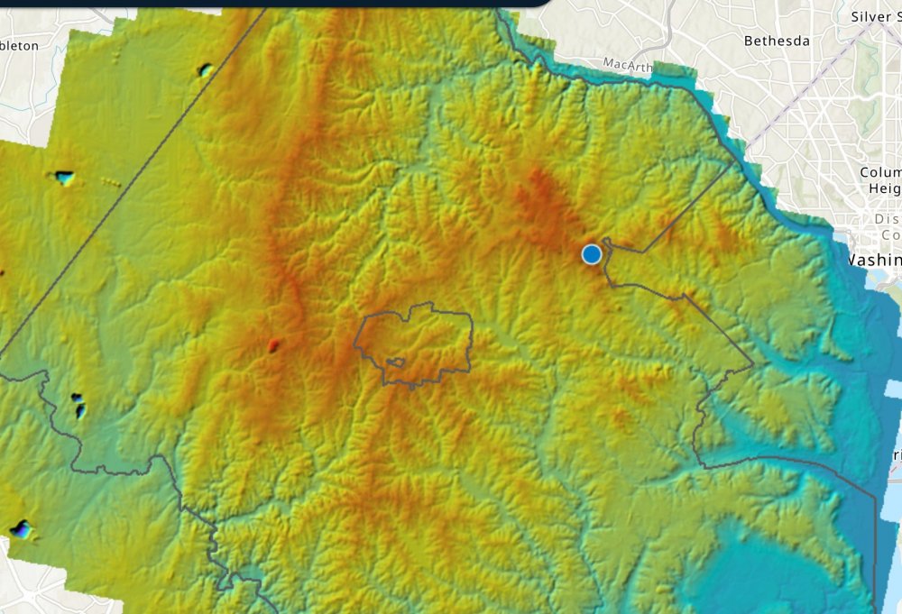
Hopefully this link works: https://www.arcgis.com/home/webmap/viewer.html?url=https%3A%2F%2Flidar.geodata.md.gov%2Fimap%2Frest%2Fservices%2FMontgomery%2FMD_montgomery_dem_m%2FImageServer&source=sd
-
Nice map too. Sugarloaf really stands out as an oddity.
-
You know my neighborhood a bit. The elevation change from the water tower down to the WO&D is 100'. On the clear/calm nights without cold air advection there is cold air drainage and I just can't get that low. Could be worth at least 3 degrees over about a block. That's why to always be wary of point measurements in heterogeneous terrain. Pretty cool lidar elevation map from Fairfax Co. https://lidar-fairfaxcountygis.opendata.arcgis.com/app/5d4d2187b01f4d62ba53787eea94496b
-
Been a while since I won one of the contests! Thanks for running it.
-
Only 30.2, but it was below freezing most of the night.
-
RIC & BWI in the books. Now we wait for DCA.
-
11:59pm low incoming! 33.3, coldest of the season so far
-
33.8 was my low. DCA didn’t have an ob below 37. First freeze in December?
-
Nobody is trading a worthwhile OL for a RB.
-
2020 Mid-Atlantic Severe Weather - General Thread
MN Transplant replied to Kmlwx's topic in Mid Atlantic
That was very Miller B-like. The line died out and reformed to my east. Trace of rain, winds in the 30s. Dud. -
2020 Mid-Atlantic Severe Weather - General Thread
MN Transplant replied to Kmlwx's topic in Mid Atlantic
Winchester only gusted to 40mph.


