MN Transplant
-
Posts
17,947 -
Joined
-
Last visited
Content Type
Profiles
Blogs
Forums
American Weather
Media Demo
Store
Gallery
Everything posted by MN Transplant
-
Quite possible that both 1958 storms would have made that list.
-
Do you have the top-10 on hand, Rodney?
-
NOAA puts out a monthly climate report. It usually comes out about a week into the next month. http://www.ncdc.noaa.gov/sotc/
-
Rodney, have you split it out before and after the move to the river location?
-
We were due for a lull after the run we had in the prior few years.
-
All-time monthly December high minimums set at IAD and BWI on the 22nd.
-
-
Hi max vs hi min is even more lopsided.
-
Very cool. High temps season to date almost dead median with the 1930-present climate record.
-
MSP's records at the time were right downtown. It could be argued that the UHI was more acute in the 1930s than at the airport location now. Of course, since the dust bowl was partly anthropogenic, you wade into other territory...
-
14.02" at DCA just back in 2006, so probably out of reach there.
-
-
I had 24.7" in the first and 9" in the second, but with compaction and drifting it never really seemed like there was more snow around on Feb 10 than there was on Feb 6.
-
That's where I get a little jealous. At no point did my yard have over 30", let alone 4'+.
-
That's funny. Honestly, I was just venting about not seeing snow and somebody in the thread asked about the snowless drought. I did the initial stat gathering, but Ian deserves most of the credit for the nice writeup and figures.
-
Depressing.
-
Incredible.
-
-
Added 2nd warmest July/month.
-
And they have been whining about it.
-
-
I had not seen anything about it, but they must have change the website for a reason.
-
Rodney, I noticed that LWX updated their monthly temperature numbers at http://www.erh.noaa.gov/lwx/climate/dca/dcatemps.txt It now has 1944 as 71.6. My old spreadsheet placed us third, but with the update it looks like this May was 4th.
-
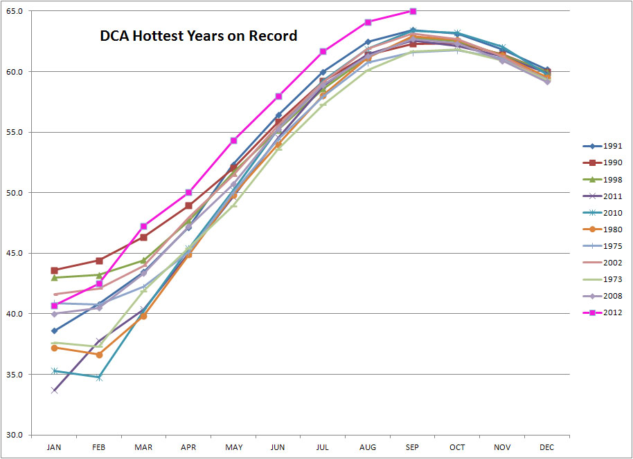
Added warmest Jan-Mar 2012: 47.3 1990: 46.3 1998: 44.4 Almost a clear 3 degrees above 3rd place. If we are merely average for the remainder of the year, we will have a top-5 warmest year at DCA. +0.7 the rest of the way makes 2012 the king. That is how warm it has been.
-
Added warmest March on record.