MN Transplant
-
Posts
17,845 -
Joined
-
Last visited
Content Type
Profiles
Blogs
Forums
American Weather
Media Demo
Store
Gallery
Everything posted by MN Transplant
-
79.9. Knocking on the door. 79 at DCA with gusts to 40. Very Great Plains-like day today with warm/windy.
-
2021 Mid-Atlantic Garden, Lawn, and Other Green Stuff Thread
MN Transplant replied to mattie g's topic in Mid Atlantic
I generally do 10 every other year. This is an off year so it is bags only. I don't really want to think about how much I've paid to have trees removed and then paid again to have different shredded trees returned. -
2021 Mid-Atlantic Garden, Lawn, and Other Green Stuff Thread
MN Transplant replied to mattie g's topic in Mid Atlantic
15 cubic yards is the most that I've ever ordered at once. That took a while to distribute. -
Some of us can max on downsloping WNW winds (especially DCA). Already 74.8 here.
-
Nectarines need to be even or above peaches. And I will not stand for any raspberry slander.
-
@stormtracker is correct. It is cherries. When they are in-season and go on sale in June/July, our fridge is full of them.
-
2021 Mid-Atlantic Garden, Lawn, and Other Green Stuff Thread
MN Transplant replied to mattie g's topic in Mid Atlantic
Yes, low voltage lighting is excellent. I love the bump in the path around the tree. -
It looked like a PRE on the models leading up to the event. Shouldn’t have been surprised that it overperformed for 95 and East.
-
1.36. Not shabby.
-
0.81”. Good soak. The plants should love this in combination with the near 80 on Friday.
-
Funny little low coming up the coast today. Certainly don't mind if it rains every 5 days or so at this time of year.
-
Speaking of which, what would you say that the difference is in climate between your two locations in terms of growing season start, leaf out, etc.? Is McHenry like a month behind Arlington?
-
Not even close to a freeze this morning. Seems likely that yesterday was it at my house. 58 and beautiful.
-
I had one deep upset team in my elite 8. VCU. Ahhh.
-
Looks terrible on mobile! Glad they did a redesign though, they wouldn’t bother if it wasn’t being used.
-
Front Range snowstorm nowcast/conditions 3/13-15
MN Transplant replied to mayjawintastawm's topic in Central/Western States
Radar and a pic from a friend in Boulder both look good right now for the front range. Hopefully everyone can back door into a hit. -
I'd be a little worried about Laramie being in a minor shadow due to the mtns to the east.
-
I cleaned out the garden beds Thursday and ran the mower to collect the junk. There was a lot of dust. Amazing how quickly it can change without rain around here.
-
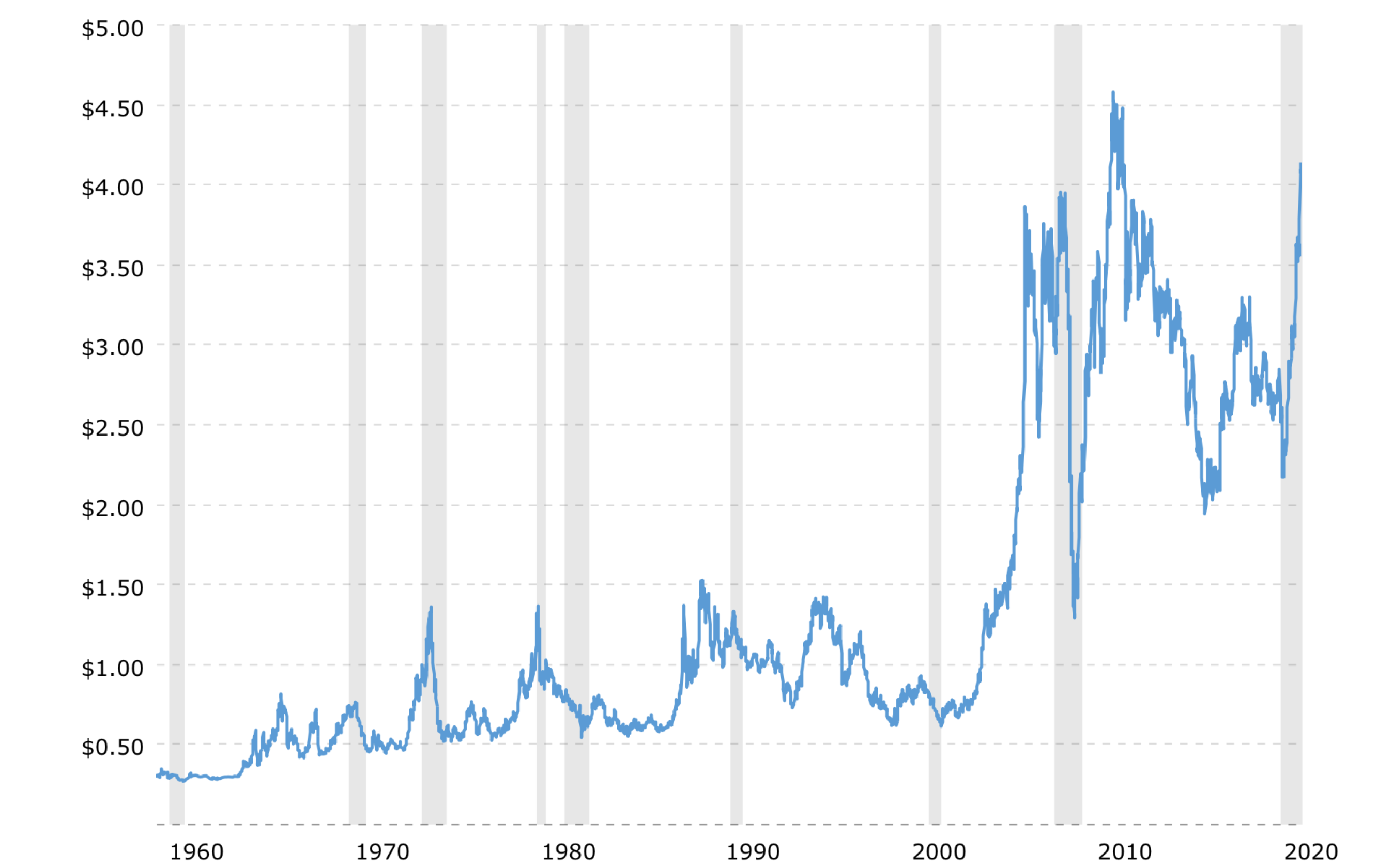
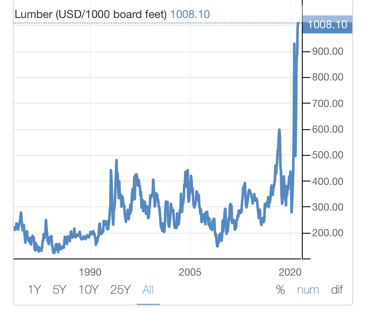
I had occasionally be checking in on lumber prices since (like everyone else who retained their jobs) we were looking at a renovation. Commodity price movements have been aggressive. (Lumber top, copper bottom)


-
If you compare modeling, though, it does look like this is the storm that finally broke the GFS. None of the others are even close to the QPF that the GFS is spitting out.
-
This one looks like a beaut all the way up to the Black Hills. Wouldn’t mind being in Estes or Nederland.
-
I had more snow in March 2013 than I did this entire winter.
-
The problem from our side is that we have zero depth at WR. It is Jefferson/Thielen and a bunch of scrubs. If there was any player that was potentially movable, it is Anthony Barr. Not sure if you need OLB though.
-
Yes, the Vikings community has been debating this since we parted with Reiff. The problem is the contract. Would we really part with draft assets and then have to sign a guy for $20m+? Especially when we are in range of potentially getting Slater or Darrisaw in the draft. The trade that I’ve seen floated is a swap of first round picks (Balt moves up to 14, Vikings down to 27) and you guys get the third rounder back from the Ngakoue trade.
-
Made it to 79.