McHenrySnow
-
Posts
701 -
Joined
-
Last visited
Content Type
Profiles
Blogs
Forums
American Weather
Media Demo
Store
Gallery
Everything posted by McHenrySnow
-
Winter 2020/2021 Short Range Discussion
McHenrySnow replied to Chicago Storm's topic in Lakes/Ohio Valley
Temperatures are really going to preclude good accumulation here. I was hoping for an inch, but I doubt it. -
Winter 2020/2021 Short Range Discussion
McHenrySnow replied to Chicago Storm's topic in Lakes/Ohio Valley
for those of you fond of the RAP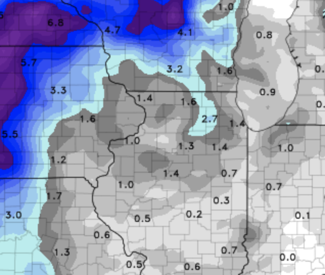
-
Winter 2020/2021 Short Range Discussion
McHenrySnow replied to Chicago Storm's topic in Lakes/Ohio Valley
huh? -
Winter 2020/2021 Short Range Discussion
McHenrySnow replied to Chicago Storm's topic in Lakes/Ohio Valley
-
Winter 2020/2021 Short Range Discussion
McHenrySnow replied to Chicago Storm's topic in Lakes/Ohio Valley
Nothing. This doesn't even warrant a WWA. I mean, if the squalls materialize maybe a squall warning or a WWA for the possibility, but they're pretty conservative with watches/warnings imo so I don't expect anything. -
Winter 2020/2021 Short Range Discussion
McHenrySnow replied to Chicago Storm's topic in Lakes/Ohio Valley
I had a crappy morning and the piling on wasn't helpful. And you say it's just snow, but snow is literally one of my favorite things in the world. Yes, I can't control it, but it doesn't mean I don't get disappointed when I wake up and see NAM and Canadian models trended much further NW with the heavier snow. Who would have imagined saying that was a bad trend would end up causing so much nonsense? Regardless, I'm done with it. There's no use trying to engage with some posters and that's fine, I know better now. -
Winter 2020/2021 Short Range Discussion
McHenrySnow replied to Chicago Storm's topic in Lakes/Ohio Valley
Not a single one of those runs had occurred when I posted. I thought y'all liked looking at trends at not hugging single model runs, but it appears to be otherwise. Enjoy your dusting that melts the next day. There's also a big difference between 2-3" and 7-10", but, of course, you know that. -
Winter 2020/2021 Short Range Discussion
McHenrySnow replied to Chicago Storm's topic in Lakes/Ohio Valley
Literally no one is melting down. Some people are just a**holes. -
Winter 2020/2021 Short Range Discussion
McHenrySnow replied to Chicago Storm's topic in Lakes/Ohio Valley
Yep, you got me, the 15z RAP is definitely not a complete outlier whatsoever. I better get my shovel ready. I really don't get some of you, other than you're just jerks. -
Winter 2020/2021 Short Range Discussion
McHenrySnow replied to Chicago Storm's topic in Lakes/Ohio Valley

-
Winter 2020/2021 Short Range Discussion
McHenrySnow replied to Chicago Storm's topic in Lakes/Ohio Valley
I'd rather expect nothing and be pleasantly surprised than the other way around. -
Winter 2020/2021 Short Range Discussion
McHenrySnow replied to Chicago Storm's topic in Lakes/Ohio Valley
Still doesn't change the fact that it has trended worse for us each run. Monday evening it was looking much nicer. Even yesterday morning. My concerns are the marginal (at best) temperatures and if we don't see steady snow, I could easily see a tenth or two falling and then melting so on and so forth. I have hopes the pattern gets better after this, but I'm not as excited as I had been even last week. Cary's 15" at ORD call by March 1 is looking good. -
Winter 2020/2021 Short Range Discussion
McHenrySnow replied to Chicago Storm's topic in Lakes/Ohio Valley
So you can't. Good to know. -
Winter 2020/2021 Short Range Discussion
McHenrySnow replied to Chicago Storm's topic in Lakes/Ohio Valley
The clouds will help. Of course, your snowpack is a bit deeper than mine. We've been above freezing since 5 am. -
Winter 2020/2021 Short Range Discussion
McHenrySnow replied to Chicago Storm's topic in Lakes/Ohio Valley
Could you elaborate as to how the trends have been GOOD for N Illinois? Or do you just prefer to name-call like a child? -
Winter 2020/2021 Short Range Discussion
McHenrySnow replied to Chicago Storm's topic in Lakes/Ohio Valley
Terrible trends for N IL. -
Winter 2020/2021 Short Range Discussion
McHenrySnow replied to Chicago Storm's topic in Lakes/Ohio Valley
And the Nam. -
Winter 2020/2021 Short Range Discussion
McHenrySnow replied to Chicago Storm's topic in Lakes/Ohio Valley
Sounds really enthused. -
Winter 2020/2021 Short Range Discussion
McHenrySnow replied to Chicago Storm's topic in Lakes/Ohio Valley
Lots of melting going on today - won't have much more than piles and drifted areas left by Thursday night, I bet. -
Winter 2020/2021 Short Range Discussion
McHenrySnow replied to Chicago Storm's topic in Lakes/Ohio Valley
The Euro is gross. -
Winter 2020/2021 Short Range Discussion
McHenrySnow replied to Chicago Storm's topic in Lakes/Ohio Valley
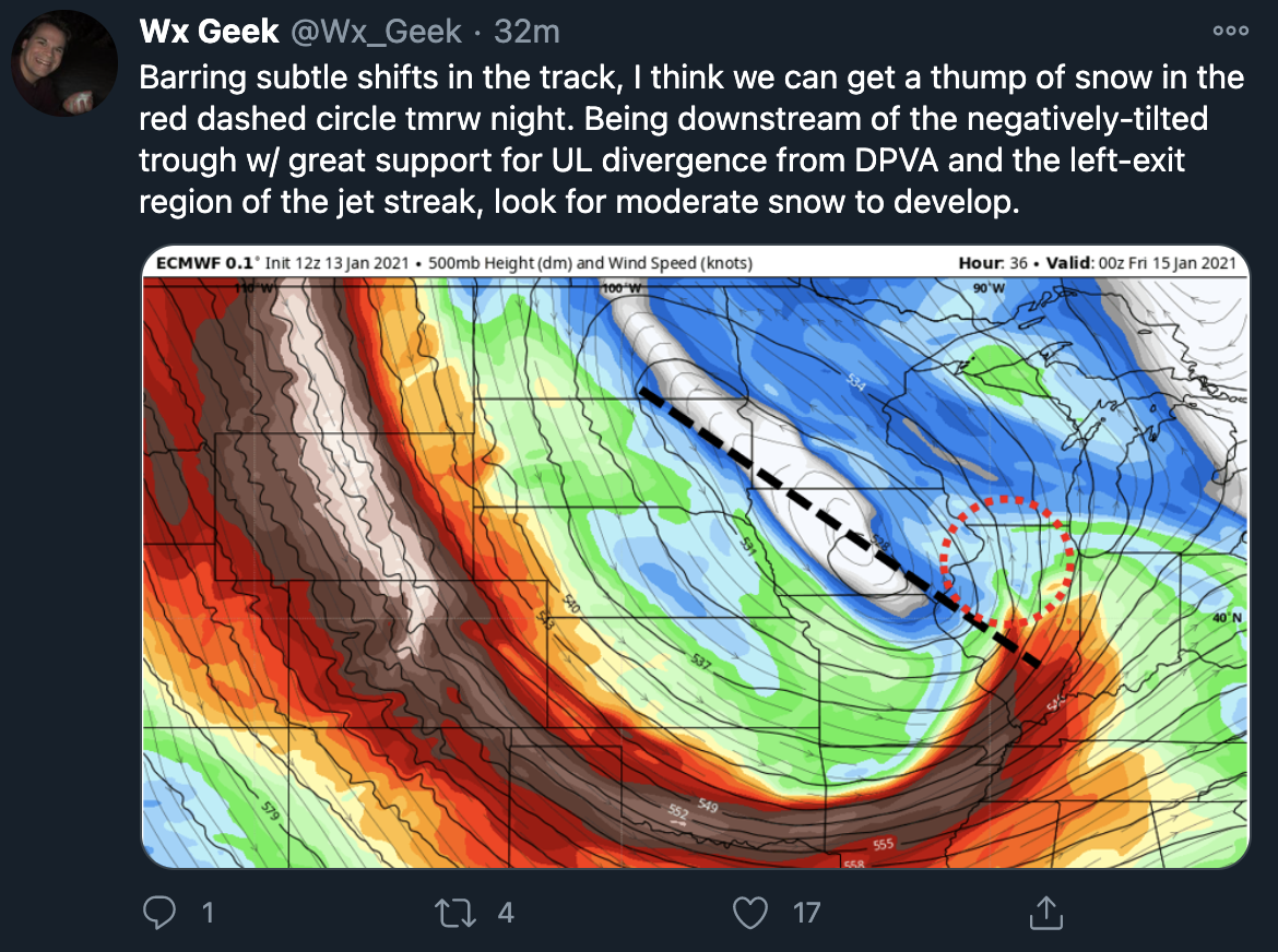
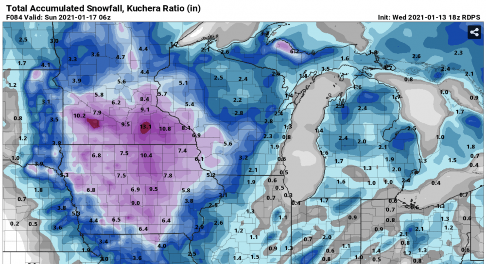
The Canadian has shifted NW. Heaviest snows over Eastern Iowa, NW Illinois, and SW Wisconsin......you know, the places that have gotten all the snow to date. smdh. -
Winter 2020-21 Medium/Long Range Discussion
McHenrySnow replied to Hoosier's topic in Lakes/Ohio Valley
NAM joins the Canadian with a few inches in N IL Thursday-Friday. -
Winter 2020/2021 Short Range Discussion
McHenrySnow replied to Chicago Storm's topic in Lakes/Ohio Valley
lol @ ukie mchenry county bullseye!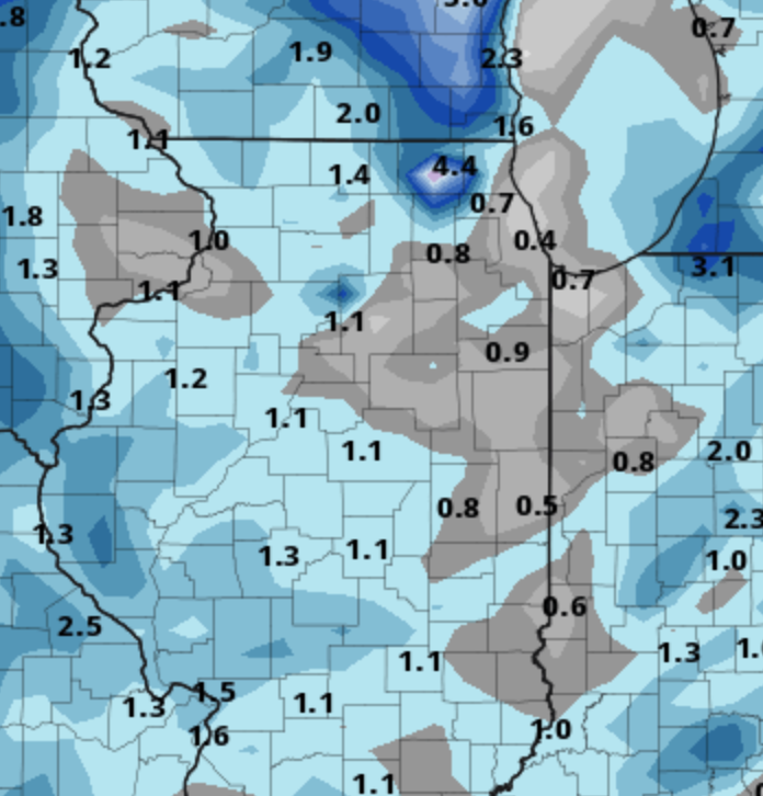
-
So large swaths of Texas and Oklahoma have had more snow this winter than Northern Illinois. Depressing AF. Don't get me wrong, I'm happy for them, but this is unbearable.
-
Yes, I'm quite confident most everyone else appreciated the sun! lol Hope you're right about Wednesday. Concerned everything will get wiped out and then it will be cold and brown. The worst!