

McHenrySnow
-
Posts
701 -
Joined
-
Last visited
Content Type
Profiles
Blogs
Forums
American Weather
Media Demo
Store
Gallery
Everything posted by McHenrySnow
-
Jan 24-26th Potential Something Part 2
McHenrySnow replied to Chicago Storm's topic in Lakes/Ohio Valley
18z HRRR a real kick in the teeth for McHenry County. Sadly looking like my 4" call will be right (if not a bit high). -
Jan 24-26th Potential Something Part 2
McHenrySnow replied to Chicago Storm's topic in Lakes/Ohio Valley
And I think they average around 33" or so? They've been blessed, that's for sure. -
Jan 24-26th Potential Something Part 2
McHenrySnow replied to Chicago Storm's topic in Lakes/Ohio Valley
No. I said the low was shearing out and less snow as you go east, but the lake would counteract that for lakeshore counties leaving the counties in the middle with lower accums. That's the same reasoning I see NWS mentioning. It's been evident for a while that this would occur. My only hope is that higher ratios further north pan out, but depending on ratios is a fool's errand. -
Jan 24-26th Potential Something Part 2
McHenrySnow replied to Chicago Storm's topic in Lakes/Ohio Valley
I vaguely recall saying this on Saturday. -
Jan 24-26th Potential Something Part 2
McHenrySnow replied to Chicago Storm's topic in Lakes/Ohio Valley
We will see. They usually find a way! lol -
Jan 24-26th Potential Something Part 2
McHenrySnow replied to Chicago Storm's topic in Lakes/Ohio Valley
bullish -
Jan 24-26th Potential Something Part 2
McHenrySnow replied to Chicago Storm's topic in Lakes/Ohio Valley
Quite the difference between 12k and 3k NAM. -
Jan 24-26th Potential Something Part 2
McHenrySnow replied to Chicago Storm's topic in Lakes/Ohio Valley
Well, the 0z NAM seems to have stopped the bleeding. Overall, certainly not drier. -
Jan 24-26th Potential Something Part 2
McHenrySnow replied to Chicago Storm's topic in Lakes/Ohio Valley
Relying on good ratios is similar to relying on lake effect in that more often than not you're going to be disappointed. -
Jan 24-26th Potential Something Part 2
McHenrySnow replied to Chicago Storm's topic in Lakes/Ohio Valley
Those counties aren't going to get lake enhancement. -
Jan 24-26th Potential Something Part 2
McHenrySnow replied to Chicago Storm's topic in Lakes/Ohio Valley
Winter Storm Warning URGENT - WINTER WEATHER MESSAGE National Weather Service Chicago IL 255 PM CST Sun Jan 24 2021 ...Winter Storm to Impact the Region Beginning Monday Afternoon... ILZ003>005-250500- /O.UPG.KLOT.WS.A.0001.210125T2200Z-210126T1800Z/ /O.NEW.KLOT.WS.W.0001.210125T2200Z-210126T1800Z/ Winnebago-Boone-McHenry- Including the cities of Rockford, Belvidere, Crystal Lake, Algonquin, McHenry, and Woodstock 255 PM CST Sun Jan 24 2021 ...WINTER STORM WARNING IN EFFECT FROM 4 PM MONDAY TO NOON CST TUESDAY... * WHAT...Snow, heavy at times, especially Monday evening and overnight. Total snow accumulations of 5 to 7 inches. Northeast winds gusting as high as 35 mph resulting in periods of very low visibility. * WHERE...Winnebago, Boone and McHenry Counties. * WHEN...From late Monday afternoon through Tuesday morning. * IMPACTS...Travel could be very difficult. Hazardous conditions are likely to impact the Monday evening and Tuesday morning commutes. * ADDITIONAL DETAILS...Some power outages are possible due to the combined effects of the expected wetter nature of the snow and strong and gusty winds. PRECAUTIONARY/PREPAREDNESS ACTIONS... If you must travel, keep an extra flashlight, food, and water in your vehicle in case of an emergency. The latest road conditions for Illinois can be obtained on the internet at www.gettingaroundillinois.com. -
Jan 24-26th Potential Something Part 2
McHenrySnow replied to Chicago Storm's topic in Lakes/Ohio Valley
4" is my current guess for my backyard. Disappointing drying trend. 0z runs will be important, can we stop the bleeding? -
Jan 24-26th Potential Something Part 2
McHenrySnow replied to Chicago Storm's topic in Lakes/Ohio Valley
Hi-res models can pick it up, but they are notoriously difficult to forecast. -
Jan 24-26th Potential Something Part 2
McHenrySnow replied to Chicago Storm's topic in Lakes/Ohio Valley
Any lake effect Wednesday and Thursday will be largely due to the system passing south of us and not the system tomorrow and Tuesday, so I can't fathom doing a 4-day total for something like that. -
Jan 24-26th Potential Something Part 2
McHenrySnow replied to Chicago Storm's topic in Lakes/Ohio Valley
Understandable, but you've had more than double most of the Chicago posters - and, without the lake, my concern is the drying trend on this side of the Mississippi. You're at least close enough to the better dynamics that you might manage more than you expect. -
Winter 2020/2021 Short Range Discussion
McHenrySnow replied to Chicago Storm's topic in Lakes/Ohio Valley
0.25" here this morning, all falling from around 8 to 9 am. Wasn't expecting a big total, by any means, but the models had been ticking up all day yesterday. Dry air won out. -
Jan 24-26th Potential Something Part 2
McHenrySnow replied to Chicago Storm's topic in Lakes/Ohio Valley
I'm betting we won't have to worry about that. -
Jan 24-26th Potential Something Part 2
McHenrySnow replied to Chicago Storm's topic in Lakes/Ohio Valley
You've done well on every storm, I'm sure you'll do pretty well on this one. I wouldn't worry too much if I were you. -
Jan 24-26th Potential Something Part 2
McHenrySnow replied to Chicago Storm's topic in Lakes/Ohio Valley
Oof. Shouldn’t have stayed up for that. -
Jan 24-26th Potential Something Part 2
McHenrySnow replied to Chicago Storm's topic in Lakes/Ohio Valley
Overall looks good to me. I'm beginning to doubt doubt digits, though localized 10" especially further west is certainly possible. -
Jan 24-26th Potential Something Part 2
McHenrySnow replied to Chicago Storm's topic in Lakes/Ohio Valley
Was in Bridgeport during the November 2018 "blizzard" - that and the snowstorm in November 2015 were heartbreakers for people who actually lived in the city (let's face it, O'Hare isn't the city). -
Jan 24-26th Potential Something Part 2
McHenrySnow replied to Chicago Storm's topic in Lakes/Ohio Valley
You can also see the lake's influence very well. Maybe too well for parts of McHenry, Kane, and DuPage.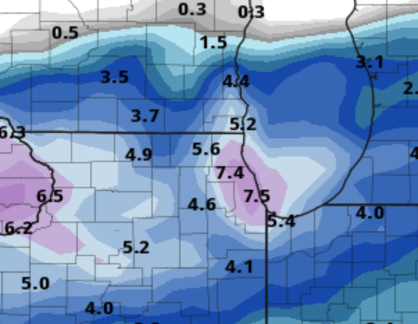
-
Jan 24-26th Potential Something Part 2
McHenrySnow replied to Chicago Storm's topic in Lakes/Ohio Valley
You have the lake to at least pad totals by a couple inches, which is always nice. I can't imagine living in the loop and loving snow the past few years. It was bad enough in Bridgeport, but we often had better accums than the loop. -
Jan 24-26th Potential Something Part 2
McHenrySnow replied to Chicago Storm's topic in Lakes/Ohio Valley
This shows the actual storm total best as the "total" accums add an inch to inch and a half across much of northern LOT from tonights snow.
-
Jan 24-26th Potential Something Part 2
McHenrySnow replied to Chicago Storm's topic in Lakes/Ohio Valley
Midnight or so.


