

McHenrySnow
-
Posts
701 -
Joined
-
Last visited
Content Type
Profiles
Blogs
Forums
American Weather
Media Demo
Store
Gallery
Everything posted by McHenrySnow
-
Winter 2020-21 Medium/Long Range Discussion
McHenrySnow replied to Hoosier's topic in Lakes/Ohio Valley
May 5th here. Spring is my 3rd favorite season, so I understand. Always wanted snow for my birthday. Never seen flakes on the day itself, but close. Saw several birthdays hit 90º growing up in Kentucky though. -
NAM is wetter, quite a bit.
-
Looking more realistic, I'm afraid.
-
more reasonable, i don't actually expect 2"
-
2" of fluff or bust.
-
GFS laughs in our faces. Still pushing the next system more.
-
Cary said we hadn't overachieved all winter and that's true. Not sure how snow depth is related to that or why you chose to single me out. FFS, I said I'd be happy to take 2". lol
-
And NMMB is a heartbreaker for north of 88.
-
high single digits
-
Ain't that the truth. That being said, I'll take it.
-
Feb 3rd - 5th Potential strong stm threat
McHenrySnow replied to Brian D's topic in Lakes/Ohio Valley
Front is through, finally. Fluff falling, wind blowing, and temps dropping. -
Feb 3rd - 5th Potential strong stm threat
McHenrySnow replied to Brian D's topic in Lakes/Ohio Valley
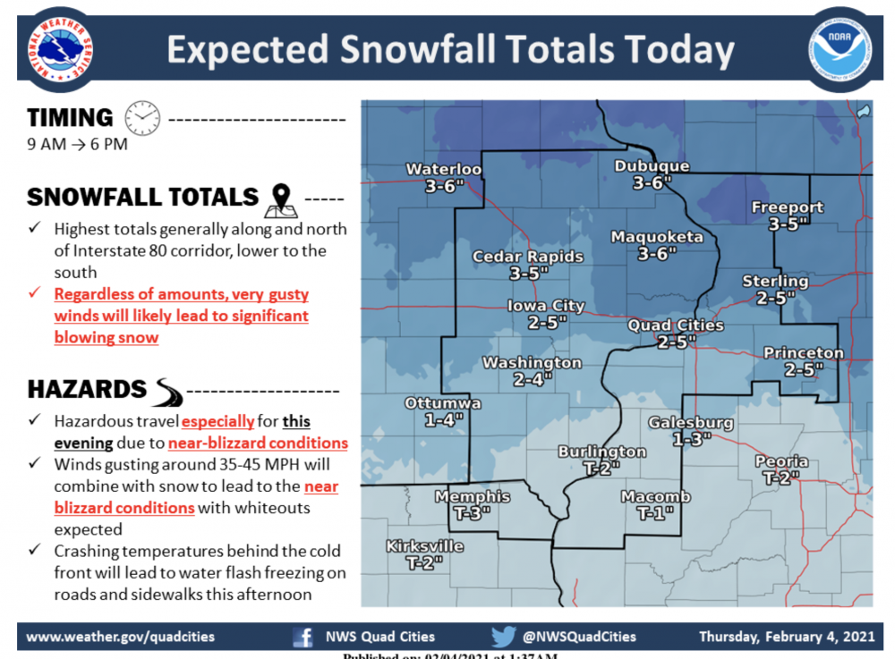
Hoping it can at least maintain itself to get me to 2". Currently around 1.4" or so. Though no doubt at least 2" of snow fell, but it's been melting and compacting as fast as it's been falling. Still above freezing here as well. -
Feb 3rd - 5th Potential strong stm threat
McHenrySnow replied to Brian D's topic in Lakes/Ohio Valley
Pouring graupel, but can't complain, it's actually sticking to the driveway! lol -
Feb 3rd - 5th Potential strong stm threat
McHenrySnow replied to Brian D's topic in Lakes/Ohio Valley
-
Feb 3rd - 5th Potential strong stm threat
McHenrySnow replied to Brian D's topic in Lakes/Ohio Valley
Another lightning strike down toward Princeton, Illinois. Just measured 0.75" here so far. -
Feb 3rd - 5th Potential strong stm threat
McHenrySnow replied to Brian D's topic in Lakes/Ohio Valley
Temp is stuck at 32.7º which means my blacktop driveway that faces south is wet. street is covered though. kind of bummed b/c i love shoveling. -
Feb 3rd - 5th Potential strong stm threat
McHenrySnow replied to Brian D's topic in Lakes/Ohio Valley
can't beat big, fat flakes -
Feb 3rd - 5th Potential strong stm threat
McHenrySnow replied to Brian D's topic in Lakes/Ohio Valley
Dropped to 32.9º now. -
Feb 3rd - 5th Potential strong stm threat
McHenrySnow replied to Brian D's topic in Lakes/Ohio Valley
This is glorious. Easily hardest snow I've seen in at least a few years. -
Winter 2020-21 Medium/Long Range Discussion
McHenrySnow replied to Hoosier's topic in Lakes/Ohio Valley
lol.....no. -
Feb 3rd - 5th Potential strong stm threat
McHenrySnow replied to Brian D's topic in Lakes/Ohio Valley
Light snow has commenced. Didn't have rain or sleet, so that's a plus. 36.5º. -
Feb 3rd - 5th Potential strong stm threat
McHenrySnow replied to Brian D's topic in Lakes/Ohio Valley
I'm not worried, I'm just being a smart ass. Hoping for 2", 3" seems high, but possibly attainable. -
Feb 3rd - 5th Potential strong stm threat
McHenrySnow replied to Brian D's topic in Lakes/Ohio Valley
Because I was told yesterday that it was not going to get so much higher than forecast as it did yesterday. -
Feb 3rd - 5th Potential strong stm threat
McHenrySnow replied to Brian D's topic in Lakes/Ohio Valley
Up to 37º. Odd. -
Feb 3rd - 5th Potential strong stm threat
McHenrySnow replied to Brian D's topic in Lakes/Ohio Valley
34.7º here this morning. I'm thinking 2" max here at this point. I can definitely see some areas overachieving and others underachieving. Anxious to see just how robust some of these bands can get this afternoon.


