

greenmtnwx
-
Posts
595 -
Joined
-
Last visited
Content Type
Profiles
Blogs
Forums
American Weather
Media Demo
Store
Gallery
Everything posted by greenmtnwx
-
Nam east
-
Come on dude, don’t play that game. It was a big disappointment, significantly reversed trends to more run of the mill. You get 6” of snow you’ll be bitterly disappointed. You’ve locked in on 18+ In your mind.
-
Double barrel slippage to the east takes it from run of the mill foot of snow to something more epic.
-
Double barrel.
-
Yes but it is considerably east and cut back.
-
NAMs gonna be slightly east. West trend at least stopped
-
Classic!!
-
Unchanged
-
People say this all the time and time after time we end up with 12, 15 even 20-1 ratios in different setups somewhat frequently. This will be more than 10, more like 12-15
-
Actually he’s been on board pumping big snows so he thinks it’s a major system. Let’s see if he ends up right.
-
SREFS no help. And they have been typically over amped.
-
Come on Jerry you’ve spent 30 years on these boards don't go soft like it doesn’t hurt.
-
Seriously? Wtf you looking at? Beers?
-
A 952mb low on the benchmark does nothing for most of our forum outside of LI if it gets there by a hook shot well offshore. This isn’t forming on the Carolina coast and riding a line to the benchmark. It’s well offshore and hooking late NW towards SNE. Keep that in mind when posting a static low pressure position. How it gets there is a big part of the story.
-
Hopefully this hugs right over BOS
-
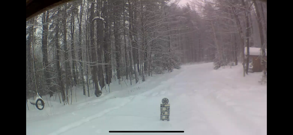
I’m at Stratton right now and it’s absolutely puking. At my cabin in West Wardsboro which is about 6 miles SE around 14” new and 17” at my yard stake.
-
Monitoring a potential important TV to East Coastal storm: Jan 17
greenmtnwx replied to Typhoon Tip's topic in New England
Nobody cares. F— off -
Monitoring a potential important TV to East Coastal storm: Jan 17
greenmtnwx replied to Typhoon Tip's topic in New England
Easy buddy. It was a joke an Phin got it. -
Monitoring a potential important TV to East Coastal storm: Jan 17
greenmtnwx replied to Typhoon Tip's topic in New England
Bustin your balls it’s all good. Congrats on that place bro. I’m slumming it in the southern greens, that Randolph view is sweet. Good thing you passed on Bennington lol -
Monitoring a potential important TV to East Coastal storm: Jan 17
greenmtnwx replied to Typhoon Tip's topic in New England
That’s cool bro. Just don’t forget to change your tampon once in awhile. -
Monitoring a potential important TV to East Coastal storm: Jan 17
greenmtnwx replied to Typhoon Tip's topic in New England
NAM definitely colder. Hope for the ski areas, settling back towards the globals. -
Monitoring a potential important TV to East Coastal storm: Jan 17
greenmtnwx replied to Typhoon Tip's topic in New England
The NAM is often right when it has the far amped up solutions. Refer to last December when everything had NW NJ and Pocono jackpot and NAM was correct with the Binghamton to Okema getting the goods while everyone else dryskotted to snizzle. -
Monitoring a potential important TV to East Coastal storm: Jan 17
greenmtnwx replied to Typhoon Tip's topic in New England
I think we know this is not gonna be a big deal for areas near the coast or even over much of SNE. The big question now is hows it going to do for the ski resorts that are in desperate need right now of a nice natural dump: that includes the Adirondacks, Catskills, Berks, Vermont New Hampshire and Maine. I wouldn’t say it’s desperation for them but it’s very much needed. They all pretty much staying white? -
Monitoring a potential important TV to East Coastal storm: Jan 17
greenmtnwx replied to Typhoon Tip's topic in New England
How’s that Friday system? La La La La La La, lock it up? -
Monitoring a potential important TV to East Coastal storm: Jan 17
greenmtnwx replied to Typhoon Tip's topic in New England
NAM 500mb extrapolated is headed to PIT


