Ahoff
-
Posts
2,755 -
Joined
-
Last visited
Content Type
Profiles
Blogs
Forums
American Weather
Media Demo
Store
Gallery
Everything posted by Ahoff
-
Pittsburgh, Pa Summer 2024 Thread.
Ahoff replied to meatwad's topic in Upstate New York/Pennsylvania
Forecast is slipping down. Not looking historic now. They’re introducing rain into the forecasts. That’s the killer, lol. Maybe we’ll get a few low 90s and one or two days at 95 at most. -
Pittsburgh, Pa Summer 2024 Thread.
Ahoff replied to meatwad's topic in Upstate New York/Pennsylvania
NWS is starting to come back down to more reasonable temps. Look a couple degrees off each day. -
Pittsburgh, Pa Summer 2024 Thread.
Ahoff replied to meatwad's topic in Upstate New York/Pennsylvania
Interesting they’d use downtown as the temperature not the official at the airport. -
Pittsburgh, Pa Summer 2024 Thread.
Ahoff replied to meatwad's topic in Upstate New York/Pennsylvania
Here's the forecast for KPIT.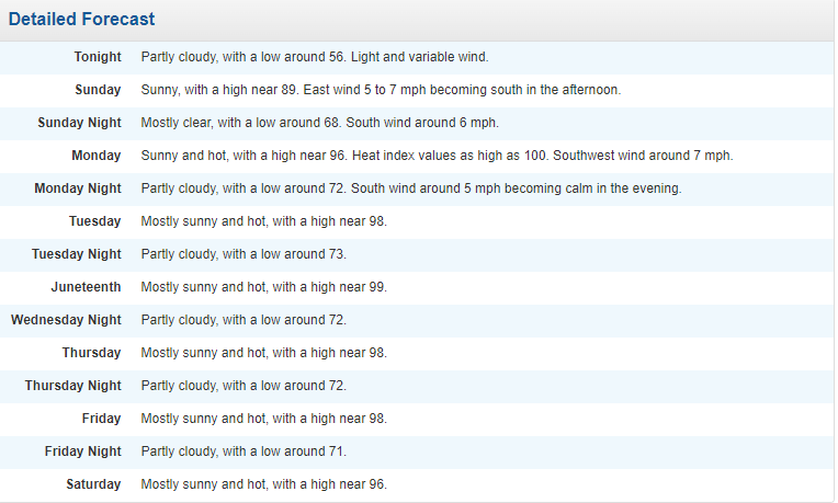
-
Pittsburgh, Pa Summer 2024 Thread.
Ahoff replied to meatwad's topic in Upstate New York/Pennsylvania
Just seems the high may be setting up perfectly (or imperfectly depending on how you look at it) for us to maximize on the potential. We’ll see if this was overhyped or not by this time next week. -
Pittsburgh, Pa Summer 2024 Thread.
Ahoff replied to meatwad's topic in Upstate New York/Pennsylvania
I’d be surprised if we’re totally clouded with the high being pretty nearly over us. Maybe a few clouds, but couldn’t imagine total cover. Or maybe they’d be those high thin clouds that still let the sun through, but a little more filtered. NWS not too interested in widespread cloudiness, though they do mentione how it could happen, but say that possibility remains pretty low for now. -
Pittsburgh, Pa Summer 2024 Thread.
Ahoff replied to meatwad's topic in Upstate New York/Pennsylvania
Oh, certainly don’t remember that one. Probably downgraded to Heat Advisory. Edit: Oh, I do remember this. This was the last day of my parish's festival, the dew point touched 80 that day. Never felt humidity like that here. High was only 90, but with a dew point that high, it was brutal. -
Pittsburgh, Pa Summer 2024 Thread.
Ahoff replied to meatwad's topic in Upstate New York/Pennsylvania
Wonder when the last time we had and excessive heat watch or warning was? 2012? -
Pittsburgh, Pa Summer 2024 Thread.
Ahoff replied to meatwad's topic in Upstate New York/Pennsylvania
NWS still hanging on. They now have that very elusive 100 degree temperature forecast for Wednesday. If we do get that close, might as well hit it. End that drought. -
Pittsburgh, Pa Summer 2024 Thread.
Ahoff replied to meatwad's topic in Upstate New York/Pennsylvania
Just never seen a forecast like that. Just odd, and have a hard time believing it happens verbatim. -
Pittsburgh, Pa Summer 2024 Thread.
Ahoff replied to meatwad's topic in Upstate New York/Pennsylvania
KDKA caved. They have some upper 90s in there. -
Pittsburgh, Pa Summer 2024 Thread.
Ahoff replied to meatwad's topic in Upstate New York/Pennsylvania
Just looked at WPXI and they’re basically with the NWS, 96 Mond, 98 Tues, 97 Wednesday, etc. KDKA is still low 90s for Mon-Wed. -
Pittsburgh, Pa Summer 2024 Thread.
Ahoff replied to meatwad's topic in Upstate New York/Pennsylvania
Someone has to cave though. Any news outlet is topping out at 94 or so, the NWS is still going up, now forecasting 99 for Tuesday and Wednesday. Going all time for June. Somewhere they have to meet. And the NWS is usually pretty conservative. Strange. -
Pittsburgh, Pa Summer 2024 Thread.
Ahoff replied to meatwad's topic in Upstate New York/Pennsylvania
I don’t remember, but this seems different, but obviously wouldn’t be surprised to stay under 95 the whole time. -
Pittsburgh, Pa Summer 2024 Thread.
Ahoff replied to meatwad's topic in Upstate New York/Pennsylvania
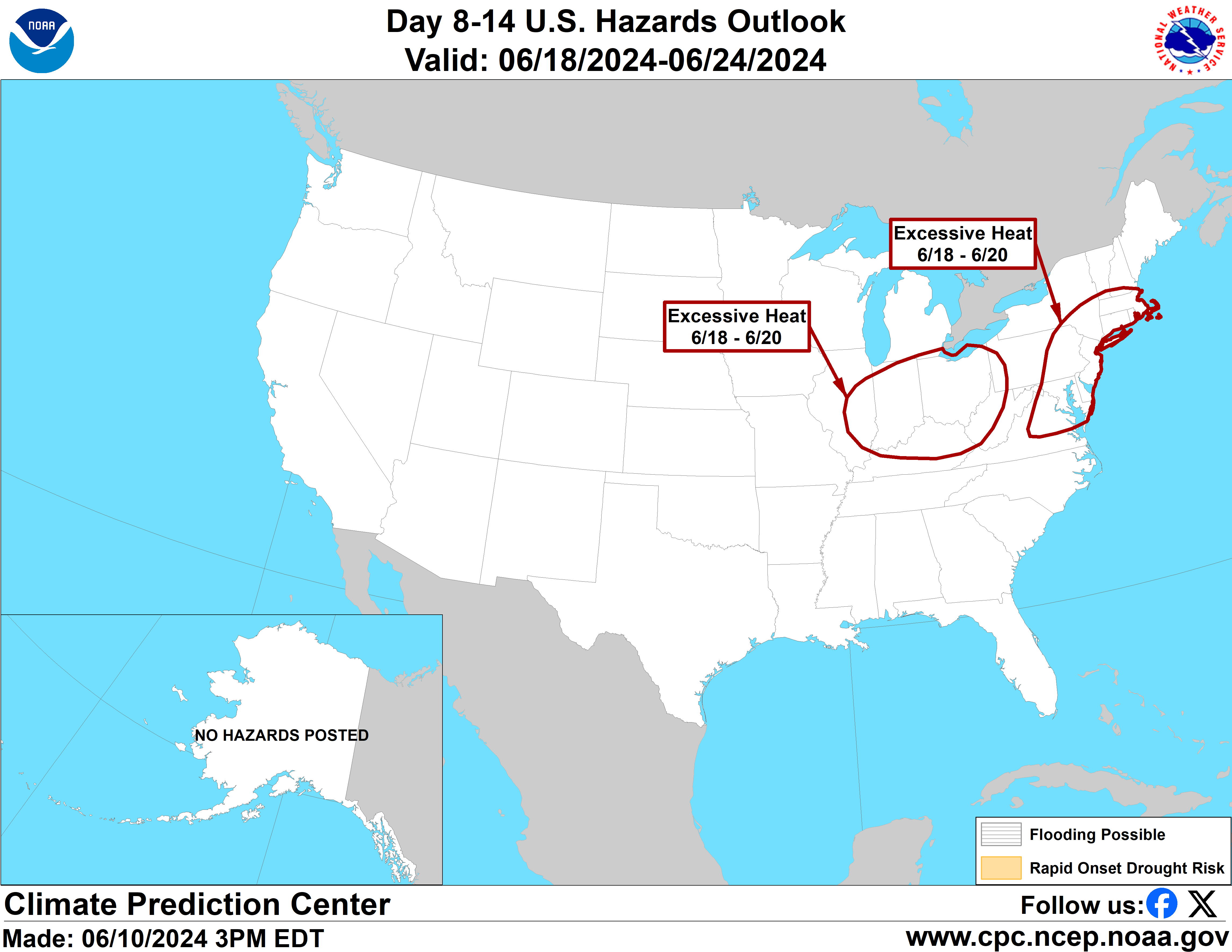
This is possibly the most significant heat wave since 2012. -
Pittsburgh, Pa Summer 2024 Thread.
Ahoff replied to meatwad's topic in Upstate New York/Pennsylvania
NWS still holding dropped Monday to 94, but raised Tues-Thursday to 97. -
Pittsburgh, Pa Summer 2024 Thread.
Ahoff replied to meatwad's topic in Upstate New York/Pennsylvania
Looks like Thursday and Friday could be even hotter than early in the week. -
Pittsburgh, Pa Summer 2024 Thread.
Ahoff replied to meatwad's topic in Upstate New York/Pennsylvania
Wow. They aren’t backing down. -
Pittsburgh, Pa Summer 2024 Thread.
Ahoff replied to meatwad's topic in Upstate New York/Pennsylvania
Newest NWS discussion mentions that if dew points stay in the low to mid 60s we have a chance at approaching 100 degrees. Wild to even see them mention that. -
Pittsburgh, Pa Summer 2024 Thread.
Ahoff replied to meatwad's topic in Upstate New York/Pennsylvania
Sounds like the Central PA crew is skeptical of 90s based on the GFS. How plausible is that outcome verbatim? -
Pittsburgh, Pa Summer 2024 Thread.
Ahoff replied to meatwad's topic in Upstate New York/Pennsylvania
While I don’t expect a full week of 90s a few days seems likely. NWS not really backing down yet on mid 90s Monday and Tuesday, and now Wednesday for that matter, 96, 94, 94. Monday would be a record hight. Will be interesting. Also, looks rather dry too (as in very little rain, not saying lower humidity). -
Pittsburgh, Pa Summer 2024 Thread.
Ahoff replied to meatwad's topic in Upstate New York/Pennsylvania
NWS point and click is up to 95 for Monday. -
Pittsburgh, Pa Summer 2024 Thread.
Ahoff replied to meatwad's topic in Upstate New York/Pennsylvania
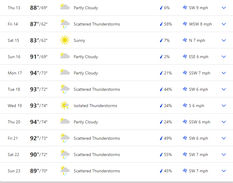
NWS point and click has KPIT at 94 for Monday. Not to say it will get there, but to see a temperature that high this far out is wild. Weather Channel has 9 consecutive days at or above 90, with a peak of 96. That'd be the longest June heat wave ever, I believe. -
Pittsburgh, Pa Summer 2024 Thread.
Ahoff replied to meatwad's topic in Upstate New York/Pennsylvania
Rare sight for these parts.
-
Pittsburgh, Pa Summer 2024 Thread.
Ahoff replied to meatwad's topic in Upstate New York/Pennsylvania
Welp, we'll see, but true summer may be upon us.