Ahoff
-
Posts
2,766 -
Joined
-
Last visited
Content Type
Profiles
Blogs
Forums
American Weather
Media Demo
Store
Gallery
Everything posted by Ahoff
-
Pittsburgh PA Summer 2026 Thread
Ahoff replied to TheClimateChanger's topic in Upstate New York/Pennsylvania
Hit 90, but fell a good bit short of forecasted highs again. -
Pittsburgh PA Summer 2026 Thread
Ahoff replied to TheClimateChanger's topic in Upstate New York/Pennsylvania
Fell short of expected highs today. Onto tomorrow. -
Pittsburgh PA Summer 2026 Thread
Ahoff replied to TheClimateChanger's topic in Upstate New York/Pennsylvania
So far 77 looks like the low. And looks like we could escape today without any rain, so that "low" might stand. Impressive. -
Pittsburgh PA Summer 2026 Thread
Ahoff replied to TheClimateChanger's topic in Upstate New York/Pennsylvania
5 minute obs are are 82 at 11:20, 90 will be tough at that pace. -
Pittsburgh PA Summer 2026 Thread
Ahoff replied to TheClimateChanger's topic in Upstate New York/Pennsylvania
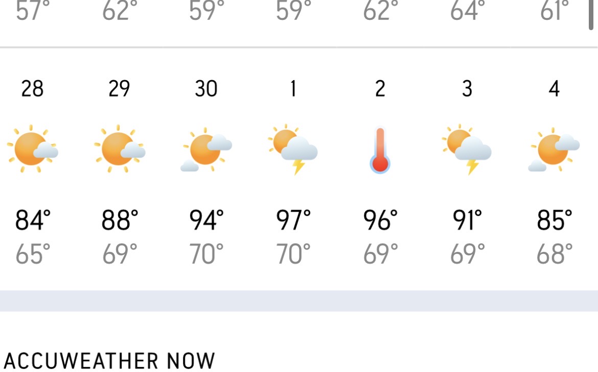
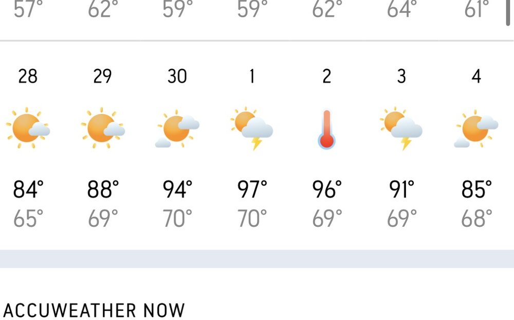
Accuweather pulled the trigger and forecasts 100 for KPIT on Wednesday. That would be the earliest 100 degree day ever in Pittsburgh. However, their forecast looks way too hot overall. -
Pittsburgh PA Summer 2026 Thread
Ahoff replied to TheClimateChanger's topic in Upstate New York/Pennsylvania
Might get hot.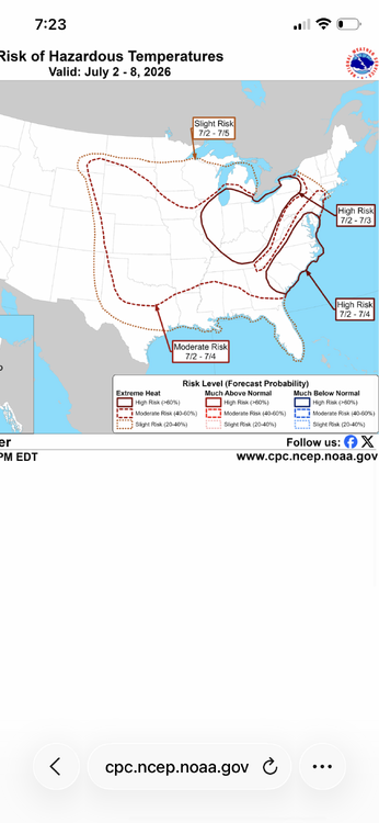
-
Pittsburgh PA Summer 2026 Thread
Ahoff replied to TheClimateChanger's topic in Upstate New York/Pennsylvania
Pretty boring in my area of the South Hills, but that's no problem for me. -
Pittsburgh PA Summer 2026 Thread
Ahoff replied to TheClimateChanger's topic in Upstate New York/Pennsylvania
Maybe hit 90 today? At least tied for warmest today. -
We’re close to 90 today, can’t see the in between, so not sure, but getting 89-Ed is at least secured.
-
Big miss today. Thought it would be way warmer.
-
Point and click for NWS is now at 93 for Monday and Tuesday. That’s the only place I see temps that high. Would be crazy, not sure I believe that at this point. It’s tough enough to hit 93 in mid July let alone mid-May.
-
84 to snow flurries in less than 24 hours has to be one of the ultimate March changes.
-
It's time to move on from winter. It was a good one, but Spring is here.
-
Pittsburgh/Western PA WINTER ‘25/‘26
Ahoff replied to Burghblizz's topic in Upstate New York/Pennsylvania
I tend to think some here truly want exactly what we had in January in March. They're just being unreasonable, lol. -
Pittsburgh/Western PA WINTER ‘25/‘26
Ahoff replied to Burghblizz's topic in Upstate New York/Pennsylvania
Yeah, I mean what do people want in March? Like we had a real true winter this year, by the time we get to March you can't expect what we had in January. -
Pittsburgh/Western PA WINTER ‘25/‘26
Ahoff replied to Burghblizz's topic in Upstate New York/Pennsylvania
Me. It's a decent snow coming down. -
Pittsburgh/Western PA WINTER ‘25/‘26
Ahoff replied to Burghblizz's topic in Upstate New York/Pennsylvania
Coldest in my lifetime. -
Pittsburgh/Western PA WINTER ‘25/‘26
Ahoff replied to Burghblizz's topic in Upstate New York/Pennsylvania
Officially -10 at KPIT. Another record. -
Pittsburgh/Western PA WINTER ‘25/‘26
Ahoff replied to Burghblizz's topic in Upstate New York/Pennsylvania
Will be interesting to see if February is also below normal like what's forecast. Can we have Dec., Jan. and Feb. all below normal temps and above normal snow? When was the last time that happened? -
Pittsburgh/Western PA WINTER ‘25/‘26
Ahoff replied to Burghblizz's topic in Upstate New York/Pennsylvania
Looks like at least tied the record today possibly broke it with potentially -6 this morning. -
Pittsburgh/Western PA WINTER ‘25/‘26
Ahoff replied to Burghblizz's topic in Upstate New York/Pennsylvania
We have a real shot at getting one of the longest stretches with below freezing temperatures. 6 days so far, but if we believe the weather channel right now the entire extended forecast stays below freezing ending the forecast at 20 days, that would put us top 5. Need 16 to crack the list. -
Pittsburgh/Western PA WINTER ‘25/‘26
Ahoff replied to Burghblizz's topic in Upstate New York/Pennsylvania
Do we think we're getting below 0 tonight? Seems too cloudy to me, at least right now. -
Pittsburgh/Western PA WINTER ‘25/‘26
Ahoff replied to Burghblizz's topic in Upstate New York/Pennsylvania
If the Accuweather forecast is to pan out, it’d be six straight nights below zero. One of the longest streaks. -
Pittsburgh/Western PA WINTER ‘25/‘26
Ahoff replied to Burghblizz's topic in Upstate New York/Pennsylvania
We could all use an extra half an inch. -
Pittsburgh/Western PA WINTER ‘25/‘26
Ahoff replied to Burghblizz's topic in Upstate New York/Pennsylvania
Really nice to have a storm that didn't flood the area with warm air and turn us to straight rain. That was a huge win. Thank God for that deep arctic air.