

Mr. Kevin
-
Posts
418 -
Joined
-
Last visited
Content Type
Profiles
Blogs
Forums
American Weather
Media Demo
Store
Gallery
Posts posted by Mr. Kevin
-
-
15 minutes ago, Carvers Gap said:
Yeah, very different circumstance to get you snow vs MBY in many cases. The EPS now has the pre-Christmas trough. That is a legit window now I think. PNA spikes positive temporarily for that model on the Euro. We don't need weeks on end of a great pattern, just need a window where it can occur. Today is the first I have seen ensembles move off their spots. Operationals are so different, that something had to give. I generally don't expect snow around my neck of the woods until January or February. We can get it earlier as we have had two great pre-Christmas snows(after going decades without those), but the norm is a six week window from Jan 1 to the middle of February. So anything right now is a bonus. If that 50/50 low is legit, that is important for the eastern half of the forum area.
Not really. A southern slider is a great setup imo. Usually a -nao to allow that. Judah Cohen goes back and forth all the time. Yesterday he said no SSW event or anything and now he is saying a possible one if gfs to believed. Or start of one. I personally would like a track of mjo from 7-2 and take our chances from there, even in a weak mode
-
 1
1
-
-
1 hour ago, Carvers Gap said:
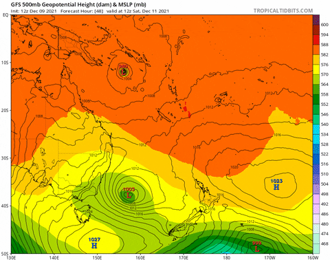
When is the last time we looked at 12z suite and are like, "Wow, the Euro looked better than the GFS?" Been a couple of weeks, but that is a great looking pattern. Ridge off the west coast popping an albeit likely temporary PNA ridge which sharpens the downstream trough. Then a 50/50ish low is parked in the right spot with energy in the southern jet timed with the northern stream. Lovely look, but ain't no way that is locked in at that range. The great thing even though that is unlikely? The pattern isn't benign.
The euro and gfs so far have a winter event to our west but obviously its early. Sw energy with -pna running into the se ridge with usually leads to ice/sleet providing its cold enough. At least from experience. Stalled front overrunning.
-
2
-
-
I'm curious which mjo rmm chart has the most accuracy? Does anyone know? I saw the bamm that webber posted.
-
2
-
-
1 hour ago, Holston_River_Rambler said:
Some of y'all may have already seen this, but Webb posted the BOMM MJO RMM forecast today (It seems like its link has been dead at the CPC MJO site since mid 2020):
I think like Jeff mentioned these tropical critters are going to slow its progression down even more and this BOMM forecast seems to show that well. Not happy to see it forecast to collapse into the COD as it moves into 8, but I think most of us would be happy to see it make it there.
Watch this little critter to the east of New Guinea:
In the past few years we've seen the MJO try to progress past 6/7ish and it gets sapped by a tropical critter in this area. I think it is the SPCZ (South Pacific Convergence Zone).
Masiello noted this as well a few days ago, in dialogue with Webb. On his gif you can see a mirror cyclone developing N of the equator as the Equatorial Rossby waves associated with the MJO pulse head east:
Found this while trying to puzzle out the connections between Rossby Waves/ Kelvin Waves/ and the MJO:
http://kejian1.cmatc.cn/vod/comet/tropical/MJO_EqWaves/navmenu.php_tab_1_page_2.2.2_type_text.htm
I thought It might be of interest to some.
Happy Hour GFS has a nice suppressed storm track:
In no way trying to connect this gif to the tropical stuff above, but thought it was a pretty pattern for fantasy land. Looks to me like HL Blocking funneling energy and cold from the pole.
I guess we all know this, but 4-6 phases aren't cold here. That chart that webberweather posted, is from two days ago. Hopefully it will be updating soon. I hope we get some cold pattern sooner or later.
-
1
-
-
9 minutes ago, Carvers Gap said:
Modeling has been awful this fall at catching trough amplifications. Ensembles will likely miss the troughs embedded in this pattern at range. I don’t use them as a primary source in order amplification as they smooth it out at range. Ensembles will be last on board. What I am looking for is not a flip to long term cold which I think is unlikely thought not implausible. So, same plan as last year. Trying to find cold shots within the pattern. As PSU noted in a great post yesterday in the MA forum, we live in an area where snow is the anomaly. It is easy just to say it is doing to be warm and not snow. The “not snowing part” is true for 95% of the days of winter or more. So, it is house money to go warm-up and rain. That is the norm. Tough part is being able to spot a trough amplification before ensembles do. So, I don’t see myself as a hobby forecaster, but someone who is hunting winter wx.
Orangeblood at storm2k made a good post today about the pattern. Supposedly the coldest air on the planet will be to our nw. Getting a mechanism to bring it south. Epo/wpo may do it if they are negative enough.
-
2
-
-
1 hour ago, Carvers Gap said:
Add the 12z Canadian to the mix as it is now picking up significant AN heights over Greenland. So that is the GDPS and the GFS which are now picking up blocking which forms around d8. Again, a lot of this is speculation until we can get it inside of d7 where skill will increase with each day at that point. The NAO is NOT a given and is notorious for head fakes, but to have it on two models with cold air already in place over NA...this raises the chances for an eastern trough amplification after the 19th. I am not saying this is a pattern change as I am not sure what pattern we are changing at this point. We have noted many times that mega ridge in the East during winter are often precursors to strat warming and cold air getting into the Lower 48.
Get the ecmwf on board, then I am more of a believer. Pattern recognition especially with ensembles
-
2 hours ago, Carvers Gap said:
Two words...NE TN. Location matters. A lot of folks outside of TRI won't think about 14-15, even on the Plateau. I probably had almost 30" of snow here in January and February alone - and that is in Kingsport which is less snowy than the other TRI. We score a bit differently than the rest of the forum area. SE KY and SW VA folks can relate to the differences of the micro climates. Kingsport does not do well with NW flow events(Bristol and JC do well), but does very well with events along the Atlantic provide we can get under a deformation band west of the Apps. Usually when it is colder in western areas of the forum, it is often warmer here. Last winter was an extreme example. Memphis got hammered for days. We saw very little.
We have both been on good ends and bad ends of the spectrum. Such strong neg -epo that winter 13-14 regardless. Ao and nao were both super positive but didn't matter because Pacific was so favorable. Or it possibly would have been 10x colder.
-
1
-
-
5 minutes ago, Carvers Gap said:
Man, you know I am old when I lived through an ancient analog. LOL. Oddly that winter was a weird deal where the polar vortex was trapped and when several deltas further south than was normal. Can you imagine the, "Polar vortex! Polar vortex!" talk if we had had social media back then. The PV(or at least a piece of the PV) sagged into E TN. Not sure I would say extinct, but would agree that is a rare, rare occurrence - even for then. 2017-18 is probably more reasonable in today's climate, and the rivers froze every bit as solid here as they did then. The 84-85 winter was not overly cold for most of that winter - was super warm immediately following and not a soul complained about those warm temps either. It was those crazy departures during those couple of weeks January that made it a cold winter. Northwest flow events were spectacular during that time frame. Man, we went to a crap ton of Saturday school to make up for those weeks. What is crazy is that many of the winters of the 80s were much warmer than the 70s, and progressively so. Having grown up as a grade schooler during the 70s in Knoxville, I am forever jaded to what "normal" winter should be like. It snowed often. By the late 80s, winters at TRI had flipped quite warm. Anyone want to take a guess at what also flipped then? The much talked about AMO. I think when the AMO flips back, those cold and snow intrusions will likely occur again but w/ 21st century climo style.
The snowy benchmark winters of my lifetime (that stand out to me):
84-85
14-15
95-96 (lived in Knoxville at the time...TRI folks would rank this year second)
A couple of years after 1975
92-93(blizzard)
93-94
09-10
So every decade has memorable snow and cold for me except for the one we just entered....Two events that I doubt that I ever see again in my lifetime are the Blizzard of '93 and the cold of January 84-85.
So while we are reminiscing about the days of old. You all know that I like the thunder in the mountains rule of thumb, right? BTW it worked again this week. Here is another....I have heard this old tale told many times. Old timers talk about trees exploding when it gets cold as well. Now, personally I think that is more likely that a tree falls during extreme cold and gets busted up pretty good. However, I had a biology teacher who spoke that like the truth in high school.
Suprised you left out 13-14 winter. It was unreal cold dude! Alot colder than 14-15 winter. Not even close in reality. Feb made 14 15 winter cold. It was cold from November to April in 13 14. Nonstop actually. Let's hope for a few weeks of cold weather here.
-
1
-
-
3 minutes ago, nrgjeff said:
Pro Tip: Don't live in Siberia. Weather is arguably worse than the political climate.
MJO wants to make progress. Oop! Another Invest in the West Pac. How will it mess up the progression and keep SER in place?
Confession: I am really salty because we have a non-refundable VRBO right before Christmas for NC skiing. Climatologically dumb move, but it sounded fun before the Christmas crowds.
Hope in the 11-15 day has a little pattern recognition help, all else equal. That kind of cold likes to ooze southeast. We'll see.
I believe it will be later rather than sooner jeff for a switch to cold. Probably around or just after Christmas. -60 below zero is too cold and with no snowpack, doubt it ends up that way
-
1
-
-
1 hour ago, Daniel Boone said:
I agree Kevin. Sure would help. Carvers made key points imo, on what would work .
Propagation n2 cold phases is tough due to driver resistance as Jeff alluded to. The way out is what we have been hoping for; Formidable HLB. Alter the flow and force the desired 500 mb config..
An mjo in certain phases could allow for that to occur HLB? I guess a multitude of things could allow that to happen.
-
I want to see some real cold down here. Feel like winter eventually. Definitely need to see a change in the hemispheric flow pattern for sure. I would guess the models and ensembles will adjust if the mjo progression is legit
-
2
-
-
1 hour ago, psuhoffman said:
This wave originating in 6 is more favorable than some recent years when we saw waves originate in 3 then slowly cycle through the MC. Additionally while 6 isn’t favorable there is evidence phase 6/7 is favorable to disrupting the PV. Makes me wonder if the colder looks from 8/1 partially are tied to the after effects of 6/7 since we know PV disruption has a significant lag effect on sensible weather. I’m not an mjo expert but from experience my guess is the wave makes it at least to 8.
I’ve seen the same theories and it jives with my anecdotal experiences. Slower waves seem to have greater impact on the conus pattern in my experience. Not to mention a slower wave moving through 8/1 simply gives us more time. Lastly I like a wave starting in 6 much better than the last few years when it seemed everything wanted to start in 2/3 then slowly traverse the warm hell phases then die right as they got to 8. No guarantees but this scenario has a much higher chance of working in our favor Imo.
I agree, but if the mjo cant make it into the more colder phases for winter, we are fooked lol. I mean stuck in the warm phases that promote warm weather. Alot of moving parts with winter as you know.
-
Just now, Carvers Gap said:
No problem. Man, sometimes I am in the school carline(or just in a hurry) and it looks good on the iPhone, and then looks like hot garbage on a bigger device! LOL.
I feel it will be later rather than earlier for any chance at a different pattern moving forward
-
Just now, Carvers Gap said:
I usually take about 5-10 minutes after each post and make sure it looks/says what I want it to say.
I understand. We just want to see a big shakeup in the pattern. Got a ways to go.
-
4 minutes ago, Carvers Gap said:
The CFSv2 at 12z reminds me of the 18z happy hour runs prior to the GFS getting its most recent update. Not saying this is going to happen. The possibility is there if the MJO manages to rotate into phase 8 which some members of the CPC MJO model group were flirting with. Maybe there is some strat stuff in play. Yes, I know it will be tough for the below scenario to occur, but it is not without precedent during La Ninas(nor is the warmth without precedent). However, high amplitude 7 even getting close to 8 could force a PNA/EPO ridge to pop. The NAO, fickle as it is to predict, is showing up in modeling now at times. Below is the CFSv2 for early January. Needless to say the departures under that are ridiculously cold. Some of those departures are twenty degrees below normal at the coldest time of the year. Now, the CFS will have a different solution at 18z. Just how that model works. This is a double block....EPO/PNA and an Atlantic block. This is not a forecast. This is spitballing for the upcoming pattern. I don't own a wx blog nor operate any social media for wx. I don't trade in futures nor do anything in the stock market. This forum is pretty much it for me. So, zero reason for me to hype. This is just discussion. This may work out and it may not. The Euro Weeklies...just flip all of the ridges to troughs and troughs to ridges.

The key Carver is to get mjo past standing wave to even have a chance. I know there is more to that than that. Anything else we need to watch for?
-
34 minutes ago, psuhoffman said:
It’s frustrating now but the very slow speed of the mjo wave will be a good thing in a few weeks.
Do you believe the mjo wave will make it past the standing wave to have a coherent mjo propagation into colder phases? I think that's really important
-
14 minutes ago, Carvers Gap said:
You know they really aren't that far off right now. Just spitballing, but I think we have a cold shot coming later this month. They are possibly sniffing out a trough amplification(no idea if a pattern change) after the 21st. But yeah, I like 17-18 as my general rule for this winter...but I think we get a second shot of cold this time around due it being a second year Nina and the QBO in our favor. November being cold is a big card. I mean the Weeklies control is stone cold while the mean is warm - not sure I have ever seen the two that opposite. The control just unloads on the forum area with -20F departures at times(and a prolonged cold shot at that). JB made a good point this evening - he noted that the AO and EPO are negative in the means for the 12z EPS late in the run(think it was the EPS but you can check me on that) where they were not at 0z. The Weeklies are derived from the morning run. Would have been interesting to see the Weeklies run from the 12z run. Maybe some light at the end of the tunnel. Let's just hope it isn't a train! LOL.
JoeB and JoeD have a good gig with weatherbell for sure. They have to hype cold to get subscribers. I understand to an extent. I wonder if they sound more realistic on the videos on wxbell compared to Twitter or FB? They are smart people and I like JoeD better than JoeB but imo.
-
2
-
-
1 minute ago, EasternLI said:
Like this?

I'm not as smart as you with charts, but what does this mean?
-
21 minutes ago, EasternLI said:
Now, that stuff is only regarding the NAO though. Thinking the emerging - EPO will cool down the final third of the month more than we're seeing right now. Canada is cold. But we'll see. Ugly pattern beforehand though. Well advertised and supported.
Do you really believe we get a legitimate -epo? I think the standing wave would have to break down to get a great propagation of mjo in phase 7 instead of a weak version. Just my opinion
-
3 hours ago, Daniel Boone said:
IF the HLB does manifest then we should be in business regardless of MJO and the crappy PAC at least in northern forum areas, as last Winter showed as long as it's formidable and stable for awhile, providing there's enuff cold from Canada to come down, of which doesn't look like a problem.
Dont you think one model will fold in regards to mjo? They both adamant about what they indicating. In 17-18 winter, shortly after Christmas, it was a strong cold blast and my car battery went dead and had to get another one. Very cold air.
-
1
-
-
42 minutes ago, Carvers Gap said:
Of course we knew the Weeklies (Euro) would be toasty. I wasn't expecting its control to be exactly (and I mean totally) the opposite for the entire run.
Webber and masiello are smart as fook lol. I don't want a blowtorch all winter, but an east based nao wont help us. West based is key imo. I mentioned this recently but the standing wave has to break down for us to not blowtorch and be stuck in 4-6 phases all winter.
-
7 minutes ago, Carvers Gap said:
Take a minute and look at the analog package graphic of the past 30 years of La Nina's. PSU notes there are two different clusters. There is a bit of a misconception the the trough is in the West. Now, also note the ridge just east of Scandinavia and the ridge in the central Pac. Those features are showing up in some variation in LR modeling.
Right now, we have the Epo and ao not in our favor for cold air. The SSW event we had last winter took 6-8 weeks to propagate correctly to the troposphere, but all SSW events aren't the same. We definitely need a fundamentally sound shift in the Pacific to really change the pattern among other things.
-
4 minutes ago, 40/70 Benchmark said:
I can honestly tell you that I expected SOME blocking this month, but I think that ship has sailed. That part is wrong IMO.....as the NAO will probably end up a bit more positive this month than I had thought...but I still expect a gradient pattern to materialize before the holidays with the cold source near by .....we do not need the blocking for that. My honest assessment.
Ray, I'm no expert like yourself, but two valid concerns on how rest of winter turns out. (1). Can standing wave break down to allow propagation for mjo into other phases besides 4-6 moving forward. (2). Will the epo and ao stay positive all winter? If that happens, it will be incredibly tough for it to get colder for any time. Hopefully we can get a change eventually whatever is needed.
-
3 minutes ago, Iceresistance said:
The +EPO is refusing to go away, the cold wave may never happen . . .

Like I mentioned, dont get excited when you see cold weather forecast because in this pattern, it's very transitory. If it happens. Just hope for one cold shot or possibly two at some point

Winter 2021/22 December Thread
in Tennessee Valley
Posted
I'm not greedy lol. I take icestorm or sleetstorm and be very content lol. Just some winter weather.