Mr. Kevin
-
Posts
418 -
Joined
-
Last visited
Content Type
Profiles
Blogs
Forums
American Weather
Media Demo
Store
Gallery
Posts posted by Mr. Kevin
-
-
14 minutes ago, Carvers Gap said:
The GFS has been all over the place, and I mean all over the place. Just needed to say that before mentioning that the 18z GFS is an excellent winter pattern. And the pattern switch/relaxation has remained around Jan 3 for the past 10-12 days(noted that before). The real question is the duration of the pattern/relaxation which brings waves of cold every 2-4 days. Best guess is that we have a couple of weeks after Jan 3rd of cold/snow. That is the window at the moment. I think folks on this subforum have done a really good job of tracking that window. And let's be honest, that is about how long those windows last in this area, 1-2 weeks of cold at a time. Would not surprise me in the least to see Cosgrove's thaw after that...and then maybe another chance later in the season if we are fortunate per his forecast.
I will also echo John's post about '84, the way these troughs are amplifying, an extreme shot of cold is on the table(single digits is extreme in my book). Just not comfortable in floating that timeframe quite yet.
Carver, do u have the 12z eps of the pna, ao, and nao u can post?
-
2 minutes ago, John1122 said:
More commonalities between this December and 1984. Parts of Alaska are setting record highs. The previous records were set in late December 1984.
Only thing I doubt is back then there was an ongoing SSW event that profiled onto the pattern and got cold for a month and a half. We dont have that now john I dont think. Hopefully we get a SSW event this winter
-
11 minutes ago, Carvers Gap said:
18z GFS loses the first system, but "found" the second one on the 7th. It is within the realm of reason that the second front could be cold enough to allow for snow if the cold pushes enough. Modeling definitely favoring the middle and western parts of the forum areas. VERY similar to last winter in that the SER will fight east of the Plateau. Need the STJ to become more active. These fronts are so strong, they are suppressing everything, but when the rebound to warmth occurs, it is nearly equally strong.
The issue now is the losing of the nao/ao moving forward with the aam dropping. We definitely need a Pacific shuffle or we in deep doo doo lol
-
Just now, CG2 said:
Agree. There could be some wild temperature gradients with these cold fronts modeled. I am not saying the GFS is right (models which flip like that could flip back during the next run), but verbatim that amount of cold would make us wish for at least a shadow of a SER in order to avoid a suppressed storm pattern.
That's why I like those overrunning patterns with sleet and ice involved. Stalled front
-
Just now, CG2 said:
At least we are tracking cold and snow for your region. Could be worse. The good/bad thing is that this is going to shift all over the place. If modeling today is true, I think there is the possibility for one storm in the western forum area and another further east as that type of boundary would likely spawn a heckuva snowstorm. I think the GOM is pretty warm right now. So an Arctic boundary hitting the GOM is fireworks.
Just a big temperature gradient from models
-
12gfs had 29 at 12noon sunday,and 41 at 12noon Sunday on 18zgfs. Euro had mid 20s at same timeframe

-
Just now, CG2 said:
18z GFS??
Yep. Weird to me
-
1 minute ago, CG2 said:
Not surprising to see that storm lift north and west. Wouldn't surprise me if it became a cutter. The 12z GFS was off its rocker. The 18z GFS has a run (so far) which is much more in line with other modeling. Trough comes eastward this time instead of meandering of the coast of California. Let's see how this run looks with that seemingly corrected(again, who knows, earlier runs may have been right).
The euro has my area mid 20s at noon Sunday where gfs has low 40s. A little off someone is
-
6 minutes ago, Carvers Gap said:
18z GEFS through 300 looks really good.
Carver, the 18zgfs was a bonk run then? You think?
-
 1
1
-
-
8 minutes ago, Carvers Gap said:
If you really want to see how complex the pattern is about to get, go to the NH view of the 18z GFS and look at it at 500. Once the Aleutian low is dislodged, chaos ensues. Model mayhem is likely on the table at this point. To me, I would suggest the potential for a progressive(but slow) pattern. Versus things getting locked in, we may well see things move...but slowly until things shake out. What is on modeling is a major disruption to the atmospheric circulation. I think we are about to see an amplified, short wavelength pattern. It is almost like the big Aleutian high was a cotter pin - kind of held things in place.
Did you mean alutian high dislodged? Lol. We haven't had one of those in a long time
-
I will say this. When the cfsv2 does the end of month forecast for following month, its usually pretty accurate. It said that December would be really warm, which it was.
-
26 minutes ago, John1122 said:
Looking back at 2015, it was a Nino acting more like a Nina out west. Bone dry in So Cal, wet and cold in the Pac NW. The Pacific was driving the pattern regardless of ENSO.
The pattern change started showing up on models around Dec 30th or so and finally arrived by mid-month. The Pac became more favorable and we had a nice 2 weeks of winter, a relaxation and then more winter in February.
Saw another year I'm going to look more into. Dec 1965 was also warm I believe, before something changed and Jan 1966 was major winter here.
Strongest niño on record I believe 15-16. It shut down DC with over 30inches mid January
-
10 minutes ago, Mr. Kevin said:
Take a look at JB'S Saturday summary. Pretty good today imo. Wxbell.com
Sorry guys. Weatherbell.com
-
Take a look at JB'S Saturday summary. Pretty good today imo. Wxbell.com
-
 1
1
-
-
Hopefully we aren't chasing unicorns again this winter lol. I believe any shift in the Pacific would help us long term and let's hope and pray it's not a temporary change because even in great patterns, it's tough, but in even tougher patterns, its almost impossible unless a incredibly timed setup ensues. I think we all know this but wanted to reiterate it.
-
6 minutes ago, Holston_River_Rambler said:
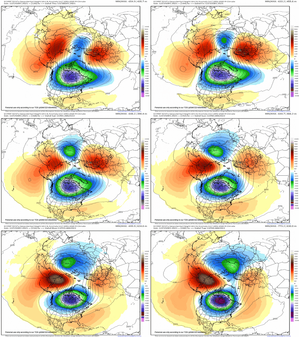
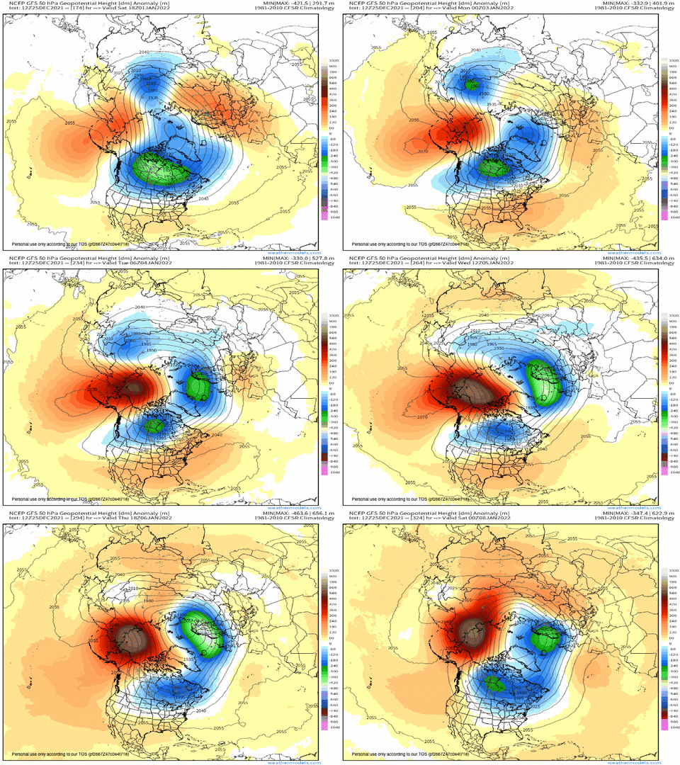
On a side note, the 12z Euro splits the SPV at 50 mb:
GFS ain't having much of it:
Still, it is under some stress at that level.
The Euro even tries hard for a split at 10mb, but doesn't quite get there.
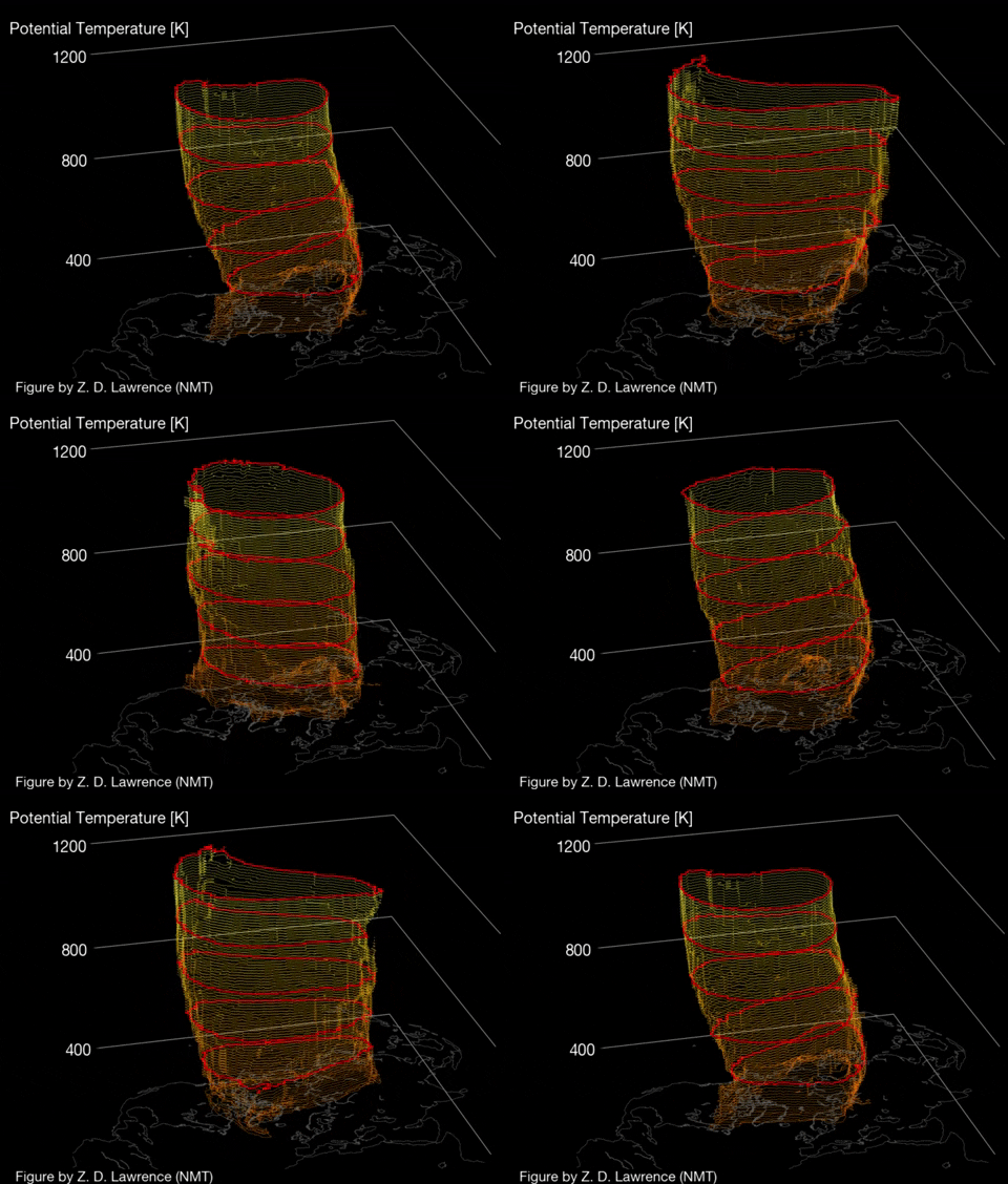
The ever popular 3D vortex rendering gets some hits and wobbles at the lower levels, but looks stout overall:
It would be lovely to see a split if it would make a difference for us. It would also be lovely to have a SSW event this winter
-
 1
1
-
-
I would like to see a lengthy Pacific shakeup or whatever it takes to get it better and favorable for cold and occasional storminess here
-
 1
1
-
-
1 minute ago, Carvers Gap said:
Not Jax or Holston, they are the SOI gurus...but when you see the SOI move like that....all kinds of movement occurs regarding hemispheric flow. IMHO, usually means a sharp pattern change would be under way. Now, we may or may not like the end result of that pattern change, but that is usually a signal of things switching up.
Just now, Carvers Gap said:The BIGGEST thing I thought was interesting....watch the Aleutian ridge on all three of those operationals. What do you all see?
I see I see I see Santa staring at me lol
-
 3
3
-
-
Merry Christmas guys! Sorry jax for being dumb with this question but what is so exciting about the soi? Lol. Everyone seems excited about it. Just confused

-
 2
2
-
-
Merry Christmas to everyone! 74 for a high here on Christmas. A little unusual but some like warm weather and some like cold.
-
 4
4
-
-
31 minutes ago, raindancewx said:
If you wanted to be optimistic for January:
Jan 1937, 1979, 1995, 2019 is very cold nationally. But I don't think that will be the look. You have 30C waters by Indonesia which create a psuedo MJO permanent phase five look for Nov-Jan regardless of the RMM
But, Feb 1936, 1978, 1994, 2018 worked for Feb 2021. December 1936, 1978, 1994, 2018 is not bad for this year with the cold coming.
So, if it gets cold, our most realistic opportunity will be February? What makes you lean that way?
-
No doubt we get a cold shot around or after new years, behind a system but it lasts a day and it warms back up. Definitely would like to get a shakeup in the stagnant pattern.
-
27 minutes ago, raindancewx said:
Did you read my forecast? I had the pattern go batshit nuts in February-March. Idea was March as a blend of 3/2019 and 3/2021 essentially. February with severe cold but shifted West of last year, and not as intense, mostly missing Texas and the deep south. February 2021 resembled a blend of February 1936, 1978, 1994, 2018 in terms of space and magnitude.
So I assumed February 2022 might look like February 1937, 1979, 1995, 2019. Here is why I think I'm on the right track:
I don't think January will be that cold overall, despite the cold shot modeled currently. A lot of warmth will show up at some point. I thought December would feature at least some record warmth if we got even remotely near MJO phase five, and we were early in the month. Idea for winter overall was a cold NW look warm SE look. Went +3 to +5 for winter in the south, locally hotter with the PDO the most negative in 50 years. There was record cold in the South in February 2015...I don't it's crazy to think the opposite is possible with the PDO as opposite as is physically possible to 2014-15.
We already have warm weather coming for Christmas and new years apparently so its here lol. I'm just trying to be optimistic we can get a shakeup so we can at least have a week or two at some point this winter
-
59 minutes ago, raindancewx said:
December is still a much weaker La Nina at the surface than last year. This is easiest to see with duller scales.
I've been quite pleased with the winter progression overall. I had this as a cold Northwest winter back in October, hot winter for the South. That looks fine so far. The idea was real simple - in 2014-15, you had ridging from Alaska to Mexico at times with a record +PDO Nov-Apr. This year has (maybe?) a record -PDO for Nov-Apr, so I went with the opposite of 2014-15, but filtered with solar/amo/enso in there too.
If you look at Nino 3.4, we keep trending warmer and warmer v. last year at the surface, regardless of the subsurface. The subsurface doesn't always translate to Nino 3.4. I mentioned in my outlook that I thought the La Nina might develop like 1967, with the cold struggling to penetrate west of 150W. That's been a good call so far if you look at the map above 12/1-12/20.
Nino 3.4
-1.6 -1.4 -1.3 -1.1 -0.2 +0.1 -0.1 +0.1 +0.3 +0.3 +0.5 (+0.3?)
 2020  27.15  27.12  27.76  28.18  27.66  27.39  26.99  26.26  25.89  25.46  25.28  25.44
 2021  25.54  25.75  26.49  27.10  27.48  27.45  26.91  26.34  26.16  25.77  25.81 -99.99
Do you think we can get a big shakeup to change things or is it not happening this winter?


Winter 2021/2022 January Thread
in Tennessee Valley
Posted
That's good news. Baby steps I suppose john