

Mr. Kevin
-
Posts
418 -
Joined
-
Last visited
Content Type
Profiles
Blogs
Forums
American Weather
Media Demo
Store
Gallery
Posts posted by Mr. Kevin
-
-
Just now, Mr. Kevin said:
I actually liked that one better than last February for my area. Nice system. All epo driven I believe
Kentucky was in the colder air longer and my area had a warm nose that took longer to erode but 6-8 hours of sleet and 6-8 hours of moderate to heavy snow. Most impressive yet
-
 1
1
-
-
3 hours ago, Daniel Boone said:
That was the Kentucky monster, lol. 2 feet central Ky.
I actually liked that one better than last February for my area. Nice system. All epo driven I believe
-
 1
1
-
-
4 hours ago, John1122 said:
It turned cold in mid February and there was a winter storm basically every week until March 6th. There was snow on snow, ice on snow and a monster snow event in Middle and West Tennessee that saw people there get 12+ with some near blizzard conditions. There was a lot of sub zero cold too.
We had a hell of a winter storm on march 5th 2015. 1.86qpf all frozen. We got 2inches sleet and 9 -10inches snow from that system.
-
5
-
-
9 hours ago, John1122 said:
The QBO has progressed deeply into the negative, around -24 to -25. Our last progression this deep into the negative in January/February was 2015 when we saw brutal cold and snow/ice in February.
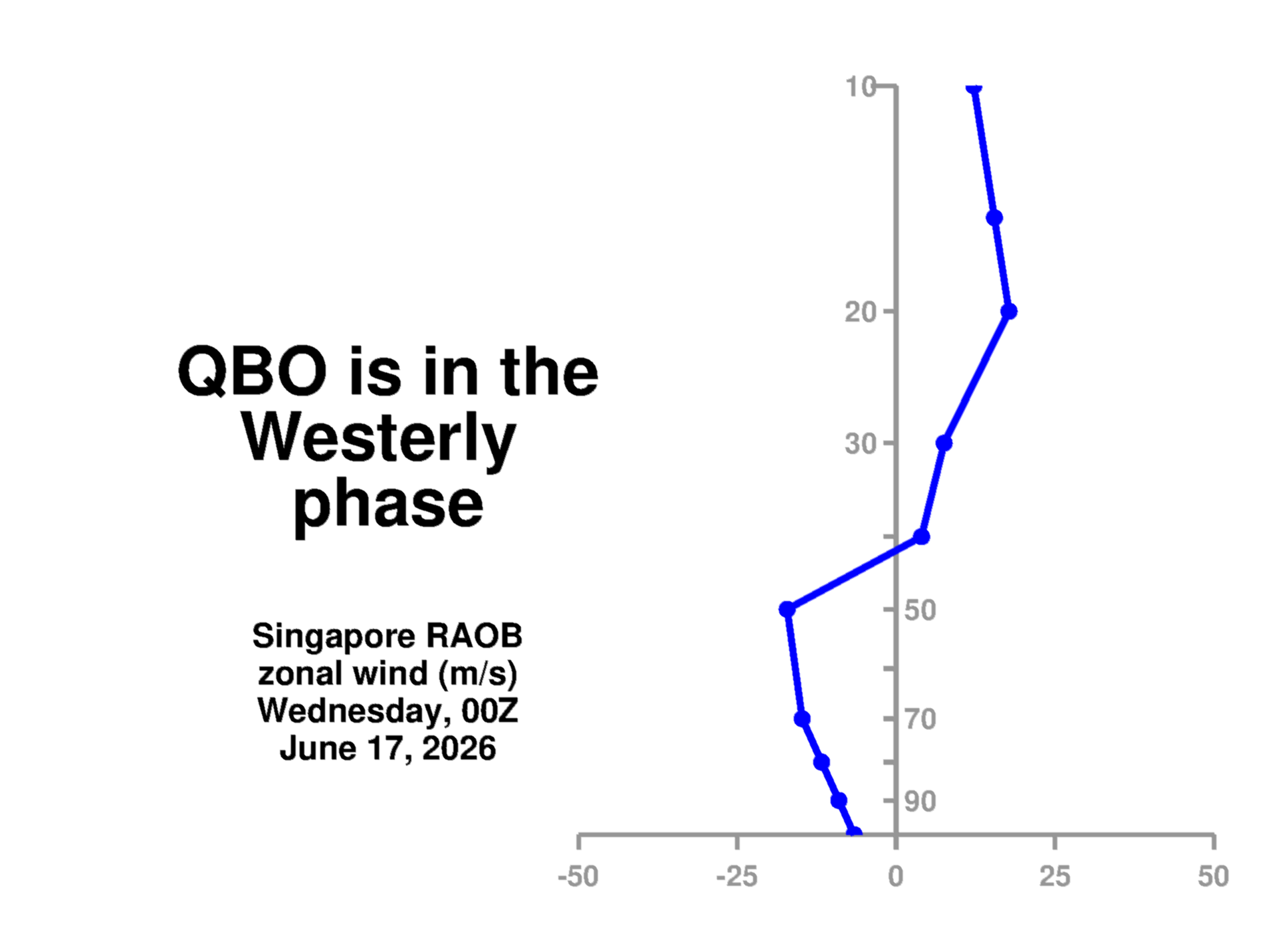
The reading for December at 30mb with the qbo was -18.62 from the cpc. I noticed that yesterday.
-
Carver, I may have missed it, but how do the ensembles look moving forward?
-
4 minutes ago, Carvers Gap said:
We want the water in regions 8-1 to warm in order to allow for convection. That would do it. @Daniel Boone had a great post about it earlier.
Whatever it takes Carver to get things continuing. 4-6 are very warm phases
-
Just now, Holston_River_Rambler said:
Sadly you have tapped out my knowledge at my post above. I would go over to southern and ask Webb about what exactly the VPs mean. Divergent winds and jet modulation is sadly about as far as I have gotten so far.
I understand holston. Just trying to think of a way realistically to continue this upcoming cold pattern instead of reversing back to warm again lol. I know I'm getting ahead of myself.
-
1
-
-
45 minutes ago, Holston_River_Rambler said:
@Mr. Kevin Sorry I saw that you asked about the MJO earlier, but I've hyperventilating about the current system.
This is probably the best I've seen convection look in the central Pac in a while:

It is south of the equator, so not sure exactly how that squares with the MJO.
Ventrice's VP plots to have an interesting evolution:

Roundy's analogue page does show what seems to me like a sensible progression through the 3rd week of January:
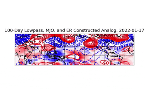
SOI also dropped to 3.82 today.
A few more things. The mjo filtered vp200 forecast chart is confusing to me lol. What do we want to see for colder weather on those charts? The soi dropping means the stj getting active perhaps?
-
Just now, John1122 said:
If we get low amp 8-1 into the heart of winter (Jan 15th-Feb 20th) I like our odds for more cold in the future.
We dont want convection to fire up in the warm phases if we can avoid it
-
2 minutes ago, Mr. Kevin said:
I'm very dumb when I look at those maps lol with the vp200 plots. Briefly explain what it means and how I can interpret them
Also why is it good to see alot of convection in the central Pacific?
-
4 minutes ago, Holston_River_Rambler said:
@Mr. Kevin Sorry I saw that you asked about the MJO earlier, but I've hyperventilating about the current system.
This is probably the best I've seen convection look in the central Pac in a while:
It is south of the equator, so not sure exactly how that squares with the MJO.
Ventrice's VP plots to have an interesting evolution:
Roundy's analogue page does show what seems to me like a sensible progression through the 3rd week of January:
SOI also dropped to 3.82 today.
I'm very dumb when I look at those maps lol with the vp200 plots. Briefly explain what it means and how I can interpret them
-
5 minutes ago, Carvers Gap said:
Think I posted one about four hours ago. I just hadn't updated for the EPS which looks good. So, will add a few thoughts. We will be a risk sometime around the 20th(if models are taken verbatim today) of a flip back to the western trough and Aleutian hp. Very unsure about that or any solution at all after the 20th. Would be very rare for modeling to hold such a steep trough in place for more than a couple of weeks. Then again the West had a great trough for about three weeks. If at some point we see a severe cold shot(single digits for lows and highs in the lower 20s), wouldn't surprise me to see it flip right after that. Seems to be the pattern for winters in this area. Great debate which is not settled regarding if the MJO takes the tour through 8-1-2. It has already defied all odds and made it into day2 of phase 8, hence the change to cold tomorrow night. Going to have some warm air masses intermingled between these cold fronts....a pattern with wild swings.
The cfsv2 has it going into 8-2 fwiw. At least today's update did.
-
10 minutes ago, Carvers Gap said:
18z GFS advertising yet another storm next weekend.
Carver, when will you give update on the ensembles 12z? You mentioned doing that earlier but you probably was busy. I hope yall get hit hard. Sunday night into Monday
-
Happy new year everyone! Definitely looking colder for a few weeks. This question may be for jax or holston. Is there any chance the cfsv2 will verify with mjo making it to 8-2? Also, what would need to happen to have this colder pattern extended past mid month? Thanks in advance
-
What does the gfs and euro have for temps?
-
Carver, just look at the 12zeps teleconnections and if the pna is around neutral or slightly positive or negative, that would imply the trough being a little further east compared to where it has been for a month now at least.
-
3 minutes ago, *Flash* said:
I'll just go ahead and ask. When you (or anyone) says, 'NAMing', are you referencing model bias with respective to mid-layer thermals/overdone trough amplification? Just want to make sure I follow.
Imo, it has the tendency to overhype stuff, or it did in the past alot, only to come back to reality as we got closer. Its actually not as bad as years ago, but the 84hr frames definitely need to be taken with a grain of salt. I know that can be with all models, but the nam was notorious with it
-
1
-
-
21 minutes ago, Carvers Gap said:
Probably is a wee bit too cold, but the CFSv2 is about as cold as I have ever seen it here - nearly off the charts. I had to do a double take as I thought I clicked on some other parameter than temps. Some of its 5-day means are 25-30F BN in the western forum areas.
MJO looks good this AM. Ensembles tend to shallow out troughs a bit more this AM, but let's see if those MJO plots begin to push things a bit. Overall, a good look and cold start to Jan beginning Jan 3.
I guess maybe a week of colder temperatures. After December, it will be alot colder lol. Webber mentions some changes in the Pacific, but it seems to weaken the pna from where it's been, which has been off the charts negative as of late. Still need a big pattern shakeup imo
-
6 minutes ago, brianc33710 said:
My concerns are for a December 1984-January 1985 type setup this winter. I emailed James Spann about the similarities about 2 weeks ago. He messaged back saying this could be worth watching. Within the last week he posted something about our Dec 84-Jan 85 similarities, I think that was La Niña as well, in response to a complaint "winters aren't cold anymore." He clearly said he didn't predict/guarantee/forecast a Jan 85 killing freeze would happen but said to keep things in mind that we could go from very warm to frigid cold in a matter of weeks.
I hope I'm wrong & worried for no reason. In fact I thought things had "warmed" enough so that we wouldn't fall below 5F/-15C ever again. We haven't seen this widespread in Cen AL since Feb 96 & they used to more frequently than now. But TX last February proved that "impossibility" wrong. Yes I remember Christmas & December 1984 were just that warm, not quite as warm as 2021 but still way above average. In fact our 77F/25C today broke the Dec 84 of 75F/24C. Unfortunately January 1985 featured the coldest temps Birmingham had seen since the 1940s. Also, the official Birmingham reporting station in January 1940 recorded a +1F/-17C low but the airport where official readings now originate dropped to -10F/-23C. So while our -6F/-21C temp January 1985 temp was the lowest "official" reading since February 1899, I'll go with the airport -10F/-23C reading from the airport in January 1940 as the better gauge over the records on file.
Rest assured we wont see 1985 cold or even feb 2021 cold for a long time imo.
-
1
-
-
The pna with its relaxation of being so negative will help allow cold to be further east and south. Always tough to time everything together.
-
The Pacific is always good to have on your side when it comes to colder weather. We want both, but tough to get both for too long imo. I believe the Pacific will turn around for a while to favor cold for us, but perhaps it lasts longer than people believe it will.
-
1
-
-
1 hour ago, John1122 said:
That's much closer to a classic Nina H placement. If the MJO is in 8, it should force the high even more East.
John, what about the hovmoller charts or the olr to show the actual place of mjo? Rmm charts can be misleading
-
1 hour ago, John1122 said:
That's much closer to a classic Nina H placement. If the MJO is in 8, it should force the high even more East.
An alutian ridge is good if it poleward, but if its flat, no dice.
-
2 minutes ago, Carvers Gap said:
I am sure I do. I normally don't look at them. I usually just look at the various regions on the map and eyeball it. I only do this as a hobby, so eyeballing usually has to do. I will give it a look later this evening. Just spitballing, In the LR looks like EPO is good, PNA neutral, NAO strongly negative. AO was likely heading negative late in the run. Looked very similar to the 18z GFS, but not that extreme. If it is going to hold, we need the AK block or EPO from the 18z GFS to lock. John is on the money with that post he just posted. He is the guru when it comes to unspoiled local climate data and Pacific patterns - I know of none better. Truly, we want cold being directed into the area and just let the warm GOM waters do their trick. The cold is the match. Gotta have it.
If the nao and ao was negative moving forward, that could be a good sign. Yesterday's run had the ao/nao moving towards neutral
-
1
-
Winter 2021/2022 January Thread
in Tennessee Valley
Posted
I got close to an inch from today's event. I was on the extreme nw side of everything. Hopefully we get into a better pattern sooner or later that will provide more opportunities for us.