

Mr. Kevin
-
Posts
418 -
Joined
-
Last visited
Content Type
Profiles
Blogs
Forums
American Weather
Media Demo
Store
Gallery
Posts posted by Mr. Kevin
-
-
1 hour ago, Carvers Gap said:
Feel free to share. Would enjoy reading them.
-
 4
4
-
-
1 hour ago, Carvers Gap said:
Models looks really good at 12z. GEPS ensemble looks perfect. -NAO is showing up. Models are sensing that feature now. Always seems like it takes a few days to reflect effects at the mid latitudes once the NAO shows up on modeling.
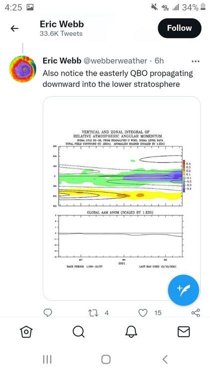
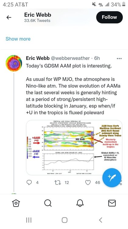
Webberweather made a few good tweets earlier today on Twitter.
-
25 minutes ago, griteater said:
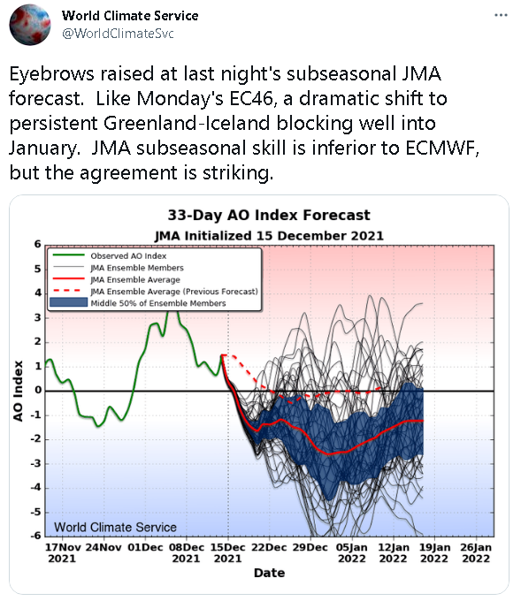
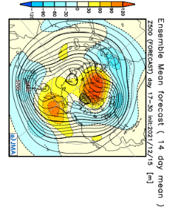
JMA Weeks 3-4
I have a question. Do you think if we get that Greenland block that's more central to west based and mjo propagation, will we get into a colder regime east of the rockies?
-
3 hours ago, Carvers Gap said:
Good info. Yeah looks east based to me which is why the SER will likely fight all winter. That little ridge in TX is also a product of that on ensembles I think.
Yes, the MJO is likely going to crawl. Looks like models have finally corrected for the tropical systems. We should now get a consistent progression with some loops(note crawling) embedded in that progression. The one good thing is if this can get into phases 8-1-2, it could be there a while and during the middle of winter at that.
I do wonder if the looping of the mjo is from the tropical cyclones in the Pacific. Until something changes, the mjo progression will be key whether we get any sustained cold down here because the pna is hurting us bad and alot of places actually. Alutian ridge isnt helping our cause also. If we get a true west based -nao in the future and dont get cold, we know we are fooked lol
-
Allan Huffman mentioned patience is required lol. 7-1 would perhaps get things shaken up somewhat. Still not cold for sure as of yet. Also, the niña is not even close to -1.1. I have been following the sst anomalies on tropicaltidbits for region 3.4 and it has averaged -.85 for many weeks, so not sure how the cpc calculates that number lol. To my untrained eye it looks like it has been east based for many weeks. Of course I'm no meteorologist lol.
-
1
-
-
3 hours ago, Mr. Kevin said:
Carver, allan huffman made a good tweet earlier about the eps shifting the nao. Imo, it would have to shift pretty far west to do us much good,because an east based wont cut it in the east, especially with the pna being negative.
Everyone should check out griteaters post on Twitter. Very good read for sure. Its 15 different parts I believe
-
1
-
-
5 hours ago, Carvers Gap said:
Thought this was a cool animation embedded in a Tweet by Webber. Found this in the MA forum. Looks very familiar to current modeling. The have another good post about the disconnect between the strat and troposphere which you can go see for yourselves. I hate just to grab all of it without sending folks to see that great thread.
Carver, allan huffman made a good tweet earlier about the eps shifting the nao. Imo, it would have to shift pretty far west to do us much good,because an east based wont cut it in the east, especially with the pna being negative.
-
1
-
-
We definitely would need a few shifts to get us where we want to be moving forward Carver. No doubt about that, even for a week or two of cold air. Get us a west based -nao, then we would be ok then I believe
-
15 minutes ago, John1122 said:
Webb noted the EPS is struggling with the -NAO still. It's very hard to have that and a SE Ridge. The best thing about right now, is that winter hasn't really started for any of us yet. We can get snow in December but it's much less common than the months to come. We are still a solid month away from the beginning of prime snow/cold climatology for the area. If we are at January 10th, have received nothing and still hoping for a SSW or some kind of blocking to actually happen we might be in trouble, but even then we've had later winters that turned severe. I believe the aforementioned 2015 had a cold shot around New Years then warmed for a long stretch before mid February brought about 2 weeks of the most brutal winter conditions many of us had experienced since the mid 1990s.
If the -qbo is legit, it should help the mjo propagation into colder phases, which kinda makes sense and either Webber or griteater mentioned that as a potential
-
9 minutes ago, Holston_River_Rambler said:
The EPS suggest a mean nudge west on the SE ridge, late in the run. This is the first I've seen it try to do that:
Seems to be in response to the -NAO pushing west. I don't have access to the run-to-run changes, but I bet they'd look nice for this one run.
Definitely want to see a west based nao or its going to be difficult in our area with the alutian ridge too far west. Hopefully we can get there
-
4 minutes ago, Met1985 said:
I think he was talking about the severe cold snap in the mid section of the country. But I can remember when we would get at least a few night of below zero readings every winter.
I was actually. It dont usually snow alot with temperature in the teens here. We can go many years without even getting temps in the teens in my local area lol
-
1 minute ago, Carvers Gap said:
The Euro/EPS completely and totally whiffed on the trough after the 20th. It was the last on board. It is always safe to bet warm in the south though.
We just want cold enough for winter precipitation here. Last February was an anomaly for sure.
-
1 hour ago, Holston_River_Rambler said:
Looky looky:
Only one run, but that is the best split I've seen on the GFS in a while. Euro is not on board.
The split is extra interesting on this run of the GFS since it is initially driven by warming over Siberia, but then a seconds warming appears to be propagating up from the NAO region at the very end of the run:
Until the euro gets on board, its skeptical for me to believe. I like all the models to indicate something like that but I understand its exciting to see
-
1 hour ago, Carvers Gap said:
The 12z CMC pattern looks really good and so does the Euro out to 180.
I have never liked the cmc because it overhypes cold and precipitation. It's better than it used to be but still not that good imo.
-
38 minutes ago, Carvers Gap said:
18z CFSv2 doubles down on the duration of cold. The control of that run is extreme with temps during the coldest week of January(second into third week) nearly 30F below normal over western parts of the forum area. I highly doubt that occurs, but yikes. That is pipe buster city right there. Generally, IF the MJO eventually rolls slowly through phase 8-1-2 during the coldest part of winter, that would be something to behold. I am way ahead of myself. Could easily go wrong. We have seen cold model runs revert to warm patterns in reality. So, huge grains of salt. I refuse to share a foxhole with the CFS.
I dont take anything for granted lol. It would be nice to see a cold enough pattern for some winter precipitation here regardless how it can happen or develops
-
Just now, jaxjagman said:
Would not trust anything that far out but it looks sweet today

I'm referring to the mjo charts from the cfs lol
-
3 minutes ago, jaxjagman said:
Meant to put MJO but didnt,surely this could change,just keep it out the Maritime
Are those charts at all accurate?
-
I'm kinda suprised the models have adjusted to a colder regime just based on mjo progression unless it's still early. Sorry. Meant to say suprised they haven't adjusted lol.
-
1
-
-
27 minutes ago, Daniel Boone said:
My 2 cents. Again, last Winter was -PDO and La nina. How often was MJO in cold phases ?
HLB was prevalent. I recorded 29.3 " snow here. Canada wasn't near as cold as it looks to be this Winter. So, regardless of who or what says no snow with a -PDO LA nina Combo without favourable MJO. Formidable HLB ftw !
Grit believes the mjo orbits across 7-2, which would imo give us a glimmer of hope moving forward. If we could develop a SSW event, it could allow real cold air to come down but like always they are real tricky
-
 1
1
-
-
54 minutes ago, Carvers Gap said:
I think I have laid out my thoughts on this pretty clearly with my earlier post. This morning. I don’t have anything to add at this point.
Not that we have a choice in the matter, I do think the MJO is going to crawl this winter. If we indeed make it to phase 8, modeling will at some point move to that colder look. It is also important to remember that the Carolinas generally get much different results from La Niñas so that impacts perspectives. Have a good Sunday!
I'm just trying to be optimistic since its winter and perhaps we will have a few opportunities at some point even though it is laniña and all niñas aren't the same
-
15 minutes ago, Carvers Gap said:
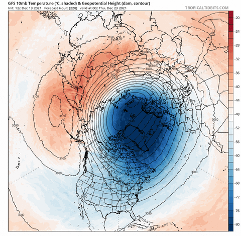
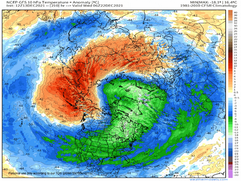
Not a ton to add this morning. The 0z Euro is by the far the most aggressive model in moving to a look which would deliver cold in the Lower 48 with original from the Arctic. As John noted, models are bouncing around. I originally just took that to be them dialing in a cold shot. I tend to agree that we are probably seeing a pattern change of some sort and of a duration TBD. The CFSv2 is what I hope we transition to, but is by no means a certainty. The MJO certainly appears to be poised to take a trip through the cold phases. Will it happen? Time will tell. If this is true, modeling is going to switch to a pretty cold look. If it is not, it will stay warm. It is worth noting that ensembles now "see" the cold where before they had a suspiciously stagnant patter. Obviously, they smooth things out....but still. If the MJO is correct, I am suspicious of any model which reverts to the big ridge in the East ad nauseam. I would suggest the pattern will be bouts of severe cold followed by extreme warmth until the pattern switches the cold to out West after mid-winter. I could easily be wrong. Let's put it this way, if I saw a model which was cold in the LR but the MJO was rotating into warm phases, I would be suspicious. The opposite is also true. Plenty can still go wrong, but to me it looks like LR modeling does not reflect the outcome that their own MJOs are depicting. To close and beat a dead horse simultaneously, if the MJO is right...we get cold for longer than a week. If the MJO is wrong, the West gets very cold for many weeks.
You may want to read griteaters post and webberweather on Twitter. Our only chance looks to come from the mjo. I feel and icestorm brewing with a -pna,but just my little bit of knowledge I have lol. Do we want a slow track through the phases of mjo for our best chance?
-
12 minutes ago, stormdragonwx said:
I made a similar post in the main Severe WX discussion thread in another part of the forum about last nights storms, but I figured I'd post here too as it is relevant to this regional discussion. NWS SGF did confirm an EF-1 tornado near Branson West, MO. Fortunately it dissipated before moving further east towards the Silver Dollar City Theme park. I can only imagine what kind of disaster that would have been if it had sustained itself and hit SDC with Christmas time crowds present as It was estimated there were roughly 20K people on site, even as an EF-1 tornado I could see it being a mass casualty event. These storms were moving between 40-60 MPH so there would be little time to react and evacuate the park with those crowd numbers. I really think theme parks and stadiums need to close and cancel events on days where there's severe weather in the forecast. (even if SDC/Branson was on the western fringe of the outlook area)
https://mesonet.agron.iastate.edu/wx/afos/p.php?pil=PNSSGF&e=202112112042
Nothing in comparison to what they saw in my area in ne Arkansas and especially in ky. Possibly the longest track tornado ever. 250 miles is impressive
-
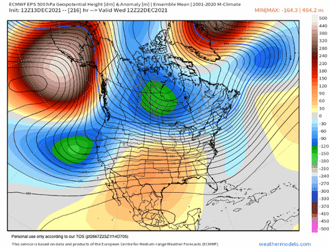
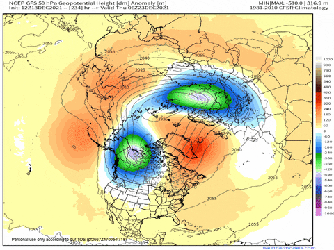
55 minutes ago, Carvers Gap said:
The 18z GEFS ensembles have a whopper of a -NAO. So, now we are beginning to see ensembles "see" the possibility for colder solutions in the LR.
I feel a west based -nao is better than east based so I believe that's what we want
-
2
-
-
24 minutes ago, nrgjeff said:
NWP has turned less hot for the 11-15 day. Do we want to ride the emotional roller coaster?
Convection is all over the West Pacific. Couple invests; however unlike last time, other deep convection is present. Maybe it will shake out well for some cooler temps in the Southeast US.
Blocking tendencies are noted in the extended guidance, but it's probably a function of the MJO. Can it verify?
Hi Jeff. I'm hoping it can. I will take icestorm sleetstorm any winterstorm over tornadoes, which were terrible last night. Hopefully the pattern will adjust to colder and stormier eventually
Mid to Long Term Discussion 2021
in Southeastern States
Posted
Griteater, I go to dacula mjo to see different rmm projections of mjo from various models. Have u been there? It has (bc) ecmwf , and gefs among others.