

Mr. Kevin
-
Posts
418 -
Joined
-
Last visited
Content Type
Profiles
Blogs
Forums
American Weather
Media Demo
Store
Gallery
Posts posted by Mr. Kevin
-
-
10 hours ago, Quixotic1 said:
I think it's a pretty good bet there will be high latitude blocking. -QBO. Coming out of a solar minimum. IO looking good. I'm hopeful. Not sure I want it after the disaster with the power grid last winter.
Its interesting we saw a -nao/ao most if not all last winter with a +qbo. Perhaps the SSW had something to do with it staying negative
-
5 hours ago, JoMo said:
Warm stratosphere = weaker polar vortex = colder in our area.
If that happens, we would get cold for a while. I believe we get cold early instead of later on. So many factors involved. Anyone making forecasts this early are completely guessing.
-
12 hours ago, Iceresistance said:
I really hope that THIS Euro model forecast is wrong! O_O
https://twitter.com/BenNollWeather/status/1439200092498522112?Why are you saying that?
-
3 hours ago, Iceresistance said:
I had 3 Snowstorms in December 2020, & the 2 BIG storms in February 2021
I had 1 ice/sleet storm and two snow storms in Feb in my area. Hope we all get at least one winter storm this winter
-
2 hours ago, raindancewx said:
The WPO is a pretty warm signal when positive for most of the US in late winter. I think you guys would have been colder in Jan-Mar without the record strength (strong lows over NE Asia).
There are so many teleconnections that can make or break winter lol. We got lucky for February with the winter storms with three in one week. It really wasn't outrageously cold except in February, especially the first half. At least here in my area. I do have another question. Which seasonal model usually is most correct on predictions for winter? I guess the better track record
-
17 hours ago, raindancewx said:
Does this work for you Mr. Sunshine? I don't have a forecast for this year yet. My general view is there is blocking this year, but the timing will be a lot different than last year. I don't expect a record, or near record +WPO like last year for the 1950-2020 period. There were countless storms <1000 mb by the southern tip of Kamchatka which is the Bering Sea rule "translation" spot for where I am, at 17-21 day leads, and it's a pretty relevant feature for late season blizzards in the SW & tornadoes in Spring. My hunch is the PDO will start to flip pretty hard late winter. Most of the local data implies a wetter/warmer winter than last year. The true dog-shit winters in the Southwest tend to see very wet Septembers in La Nina / cold ENSO years. Look at 2005, 2008, 2013, 2017 in September v. 2007, 2011, 2012, 2020 in terms of recent years. I'd be happy with an inch of rain this month (about average) at this point.
If you look compared to last year, the Indian Ocean Dipole is also more of a thing this year. So I'd expect different tendencies for where the MJO amplifies or de-amplifies.
Raindance, do you think the Pacific was pretty hostile last winter or it could have been colder? How do you see the IOD playing out with the mjo or is it still too early?
-
2 minutes ago, It's Always Sunny said:
Antecedent Gulf hurricanes lol
I think it's a quick start to winter and ends early, typical of laniña. 2nd year niñas are tricky at times
-
28 minutes ago, raindancewx said:
This is how my analogs did last year for anyone curious. I was trying to create a +WPO La Nina based on how similar the Nino 3.4 data in 2021 was to 2007. But I also expected more blocking than that year, with the Apr-Dec NAO correlation (r-squared) around 0.2-0.3 in La Nina years. The -NAO in April was quite strong in 2020, like this year. It's freaking hard to get a major +WPO in a La Nina, but the tendency is that the WPO goes positive in the lowest sea ice extent years, and I knew that heading into last year.


Are there any similarities from last winter to this winter or do you expect a different outcome? Various models show various possibilities for this winter so far. Most teleconnections are hard to predict more than two weeks out, as you know
-
8 minutes ago, Chris78 said:
I'll roll the dice with a negative AO any winter. I know you know this but last years pacific was complete garbage. I think without the - ao/nao it would of been a wall to wall shut out.
A +pna also helped some because it was skewed positive last winter
-
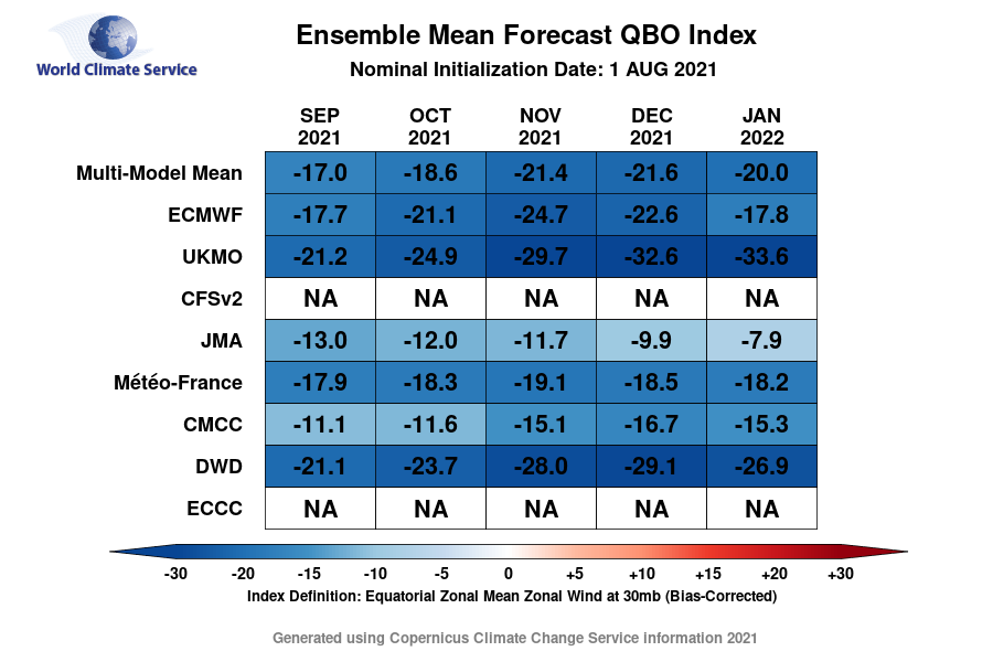
53 minutes ago, John1122 said:
Dacula Weather has these handy maps to look at regarding the QBO. It's better as a rule if it is falling through winter. But those forecasts above would generally be good news according to these reanalysis maps.
I know the climate has changed dramatically since the 60s, but I looked at the qbo for the colder winters back then, especially the 70s and the qbo was moderate negative in every one of them for dec-feb. It was interesting to me
-
 1
1
-
-
50 minutes ago, George001 said:
It is? I thought the trough out west was bad. Even Metfan starts to panic when he sees a trough in the west. When Metfan is panicking that’s usually not a good sign, as like me and James (rip) he has snow goggles and tends to be too aggressive with his forecasts. My concern is that with the trough in the west and the strong pacific jet that the pattern would be really zonal, with ceiling being a 6-12 inch storm if everything lines up. I am looking for a severe winter with at least 3-4 massive blizzards like 2010-2011, 2014-2015, ect.
I'm no expert like most are on here, but the monthly maps should become more realistic as we get closer.

-
Opinions on qbo moving forward
-
2 hours ago, raindancewx said:
I'm fairly optimistic for snow in the Northeast down to about Virginia at the moment. Don't think it will be cold overall though, or even that wet.
What reason do I have for that? The +WPO sort of fought off the -NAO signal in January in 2021 for you guys. Will that happen again if it goes negative? It could, but the WPO+ was at record levels in January, and it's a warm/anti-snow signal for a lot of the eastern US. I'm optimistic again for blocking at this juncture for the winter, but with less +WPO influence.
You can sort of see the -NAO v. +WPO fight last January. Both are snowy signals out here, which is part of why I was fairly optimistic for SW snowfall last year despite the La Nina. It was a top five snowfall year since 2000 in Albuquerque even with the total precipitation for Oct-Mar something like -40% compared to averages. Not like it was particularly cold overall, despite some impressive bursts in Sept/Oct, Feb/Mar.
Why did we have a +wpo most of last winter? I think it's too early for anyone to really know what will happen imo
-
I don't think many people going into last winter thought it would be as cold as it was, especially with a -ao and nao that prevailed. Of course with climate change, winters now wont be as cold as they used to be years ago. As long as we can sneak in one or two winter storms, I'm satisfied.
-
3
-
-
On 8/3/2021 at 4:25 PM, Carvers Gap said:
Oddly, 95-96' has a similar flip...just a bit later. 09-10 and 14-15 also have a QBO that flipped almost exactly at the same time as this summer's.
The qbo was positive last winter and we had a -nao/ao most of the winter.
-
2 hours ago, 40/70 Benchmark said:
No, no....I agree that modularity is more important than mode...you want mass flux, and this is what is paramount for major cyclogenesis...of course. All I meant was that you want it rising from -.5 and not +1, or else you run a much larger risk of precipitation type issues.
We more or less agree.
I appreciate your response to my question 40/70. I dont believe many people got last winter ao/nao being that negative, considering being in a +qbo. I know more factors are always considered when it comes to winter. I would like to see a few years of a -nao west based. I do wonder 40/70, if the niña wasnt as strong as it was last winter, would it have been colder?
-
On 7/22/2021 at 10:02 AM, 40/70 Benchmark said:
2013-2014 and 1993-1994 are both overrated winters for me because they under performed locally.
Hi 40/70. I have a question. I read your final notes on last winter at 33andrain.com. If we get a weak niña and a -qbo this winter, do you think we can get a relatively cold winter this winter, all else being equal? I know its early, but I was curious what you keep an eye on for what type of winter could happen
-
On 7/19/2021 at 2:24 PM, nrgjeff said:
Yea winter may be a lot of +EPO. First I am cautiously optimistic we get a nice fall.
Persistence is seasonable to even slightly below normal temps. Humidity is ludicrous right now, but summer actual temps are so far canceled. Heat is parked in the North Central US.
A stubborn +ABNA contributes to persistence; however I acknowledge, spring to summer patterns can be meaningless the next fall.
Fall foliage: If August continues the mild trend then soil moisture will be at or above normal going into September. Even if the hemispheric pattern shifts in September, foliage should be fine. By mid-Sept. trees start going to sleep before colors change. Only a ridiculously warm October would derail fall foliage.
Risk of a warm October is on the table. However there's no reason to forecast much above normal temps at this time.
Winter looks ugly for those of us who like snow. Mid South (as noted above and ENSO thread) could snag a couple storms per Nina climo. Rest of the Valley might need a mesoscale miracle. Maybe spring will be good storm chasing.
Jeff, I dont think many predicted last winter to be as cool as it was compared to previous winters at this time last year.
-
Hi guys. I hear alot about Hadley cell expansion and when it happens, winters are tough to get real cold. My question is for who knows more than the average person about that is where is the Hadley cell located and anyway to tell if it is or will be expanding? I believe it has a profound effect on the north Pacific pattern
-
I have two questions. Do you expect the Hadley cell to be expansive again this winter or is it too early to tell? Also, will we need to see just as good as a hlb type setup this winter as last to even have a remote chance? Keep in mind the laniña was moderate last winter and we did manage to get a few shots of cold air, especially west of the apps.
-
It was a good winter here in jonesboro ar. What a record cold and snowy February . Probably something we wont see again for many years. About 12in from two events! It was snowing in low teens. I know it's still early, but what is everyone's opinion on this coming winter?
-
I think there is too much troughing out west to get anything significant in terms of colder weather lasting more than a day or two. I think mid march could be colder with mjo progression
-
21 minutes ago, JoMo said:
What a change on the 18 and 00z gfs.
I think -ao/nao forcing a se trend with system. I believe its only the beginning from this point forward. I'm pulling for some snow and ice in the midsouth north of i40 in my area before winter is done.
-
Jomo, hopefully yall see some ice sleet. I'm in jonesboro ar and Saturday night I was tripping when I saw the gfs showing 13inches snow. Fun while it lasted. Just still not enough cold air yet.
Winter 2021-2022
in New England
Posted
I have a question. Do you think we can get a more robust aleutian ridge to build up instead of the flat type, which doesn't bring any cold air to us this winter or is it too early to tell? I think last winter it was relatively flat and we depended on the ao/nao to get cold imo