

Mr. Kevin
-
Posts
418 -
Joined
-
Last visited
Content Type
Profiles
Blogs
Forums
American Weather
Media Demo
Store
Gallery
Posts posted by Mr. Kevin
-
-
8 hours ago, NC_hailstorm said:
Looks like the 12z Ukie is bringing that cutoff energy in the SW through here around day 6.
Low right through the upstate of SC with good rain totals,0z Euro cuts the low through Ohio with rain as well.
Hi nc. Will you do your mjo updates and where it currently is and where it going? You are very knowledgeable on that.
-
33 minutes ago, jaxjagman said:
Euro shows a system coming off the Lee,no artic highs behind it but the storm does go -VE tilt into the plains which would cool us down after,by the Euro we could see the entrance of a 110-120kt jet with the 850's warming above 10C,so you can't rule out severe,but i'm looking at the Euro 9-10 days away,so you should know the drill by now..lol
Jax, you and carver do a great job btw. The mjo charts on the cpc and dacula weather are so misleading because i dont know where it is now lol. I thought it was in phase 8 fixing to enter 1, which i thought were colder phases, especially in December. Is that correct or not? Sorry for the confusion. If those locations arent good, where is the best location for accurate mjo stuff?
-
11 hours ago, Bob Chill said:
I like this site. I haven't seen dacula's page so might be similar
https://www.cpc.ncep.noaa.gov/products/precip/CWlink/MJO/CLIVAR/clivar_wh.shtml
ECMF has the highest verification scores but I look at all of them and see the spread. Sometimes they all look similar and other times very different. When in doubt hug the ecmf
Thanks bob. Dacula weather mjo is a site where about 12 different opinions on the mjo progression are there, but its confusing because even the ecmwf has more different views and one says something different than the other one lol. Check it out. I am just trying to find out where the mjo is now and which has the best handle.
Forgot this. https://www.daculaweather.com/4_mjo_phase_forecast.php
Thats where i go. Hasn't been updated today yet.
-
17 minutes ago, Bob Chill said:
Dude, if you find the 18z gefs troubling the you must be trying hard to find something wrong. It's another great run and implies cold to very cold temps will kick off Dec and continue. Snow in Nov is always great but unlikely. All I see is an amplified cold pattern setting up in early Dec. We havent had that since 2013.
Hi Bob. I have a question. When i go to: dacula weather mjo, it has various models showing the progress of the mjo moving forward. Which model has the best estimate of the mjo forecast propigation? I am just confused.
-
1 hour ago, jaxjagman said:
Have to wait and see on the MJO, IMHO.The RMM'S are showing the progression again will slow down , thanks to the +IOD so seemingly the MJO is going to creep though Africa and then the Westen IO.The RMM's show today the MJO is going to get back into the Western IO then go back into COD.IF, it goes into the COD and stays more or less out of the Maritime,these are cold phases into Dec.But we'll have to wait and see right now,but i don't believe it's as progressive as the CFS is showing

Hi jax. Do we want the mjo to stay in phases 8-2 as long as possible for this time of year or does it matter only for later on? Im not sure which one we want.
-
1 minute ago, Carvers Gap said:
MJO is tricky right now because the phases that correspond to cold during fall are not the same as the ones that do so during winter. Right now, we are just about two and a half weeks from met winter beginning. So, it kind of has one foot in and one foot out in terms of...Do we use the fall phase correlations or the winter?
Seems to me that outside of the GEFS, the western ridge is still a consistent ridge on modeling. Probably has been more a PNA ridge thane EPO so far IMHO. Either will work, though they do change precip amounts here. Also, don't want those ridges so tall that a trough tucks into the NW under it.
A good quote from a poster a few years back...we know we are in trouble if we are having to watch MJO phases. Now, the MJO carries a ton of weight in my book. What the poster was basically saying is that a good pattern will often override the MJO influence.
It is tricky i guess. I just don't understand why people think we are in a modoki elniño. If we are, we should have a pretty cold winter, but not everytime. Its all confusing to me.
-
 1
1
-
-
12 minutes ago, Carvers Gap said:
Yeah, I agree. Would be super surprised to see that hold in place for very long during winter. Although it seems like during a recent winter the WAR retrograded into eastern NA and did something similar for a few weeks and actually triggered an SSW. Yep, that occurred during one or both of the last two SSWs. So for the ah-ha moment of the evening, that look actually has proceeded the last two strat warming events - I think...definitely one. Your comment actually jogged my memory on that. It is indeed rare...but now I remember where I have seen it before. So, it will be interesting to see if an early winter SSW occurs. Maybe that is an example of a tropospheric planetary wave that potentially could transport a ton of warm air into the high latitudes. That could potentially displace the PV. At one time, I had made a mental note to remember that look....it is probably buried in one of the threads where we talked about SSWs.
Below is the eastern NA ridge connecting to the -NAO. The EPS does not have this...trough is in the East. Anyway, I am not using a 384 hour map for any other purpose than to show what I was talking about. Only 64 more GFS runs before we reach that time frame! Anyway, that look is super similar to the WAR that hooked up with the -NAO that preceded one or both of the last strat warming events. Interesting.

Hi carver. ISOTHERM'S forcast scares me too lol. I dont want him to be right if we have any chance this winter. Why do you think the epo/wpo are going positive? Is it the mjo moving to unfavorable phases? I am still clueless with that.
-
5 hours ago, JoMo said:
Light snow/flurries here, just sleeted a bit ago as well. Looks mostly over now. Got a dusting.
Hi jomo. We may get cold again when mjo makes it back to the 8,1, and 2 phases? It looks like we are going to warm up for sure once mjo makes it to the 4 5 and 6 phases. Im just confused on all this lol.
-
I am kevin from ne Arkansas. I do have a question. What do we need to watch for to see if December and rest of the winter will be cold? I think most are curious about what.
-
9 hours ago, Bob Chill said:
If you look at Nov 2013&14 npac SSTA plots they look pretty similar to this year. . This year looks like a blend of those 2 years (especially ENSO regions) and I find it encouraging.
Here's current, Nov 2013 and 14 SSTA plots:
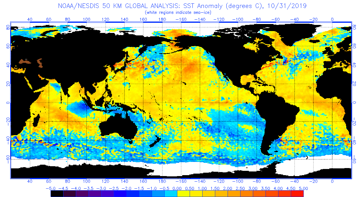
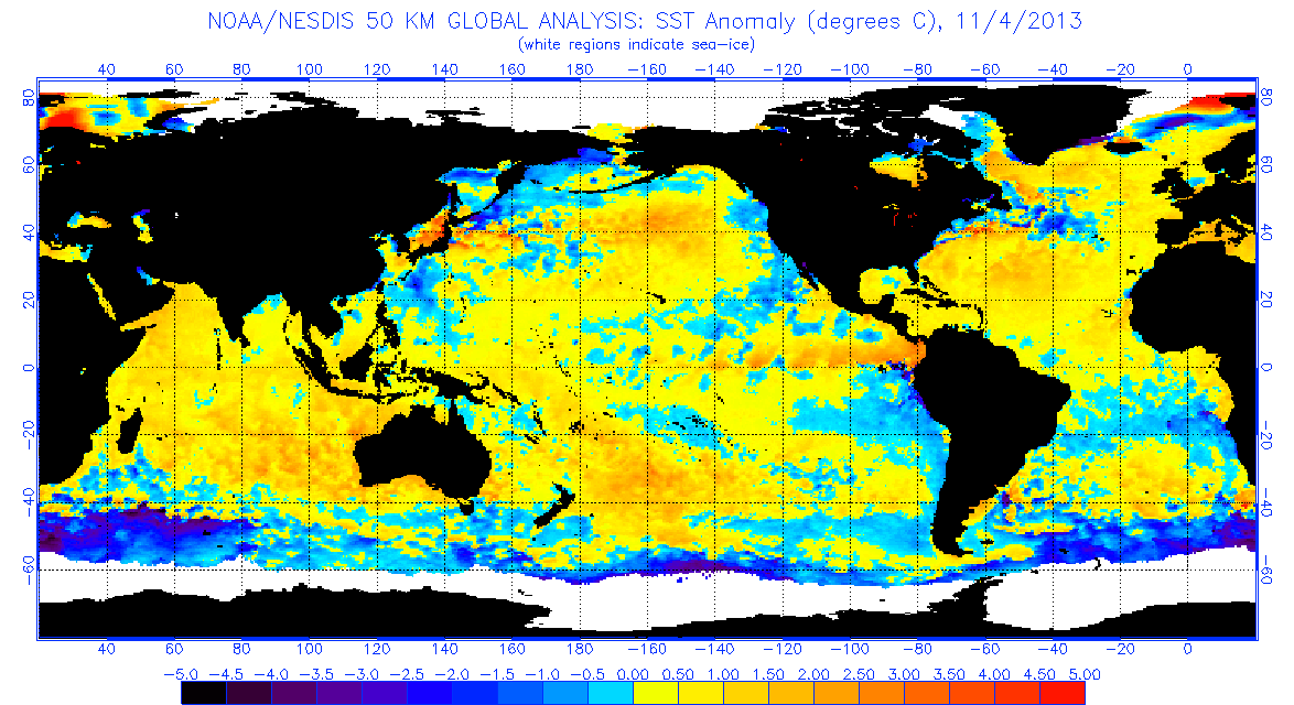
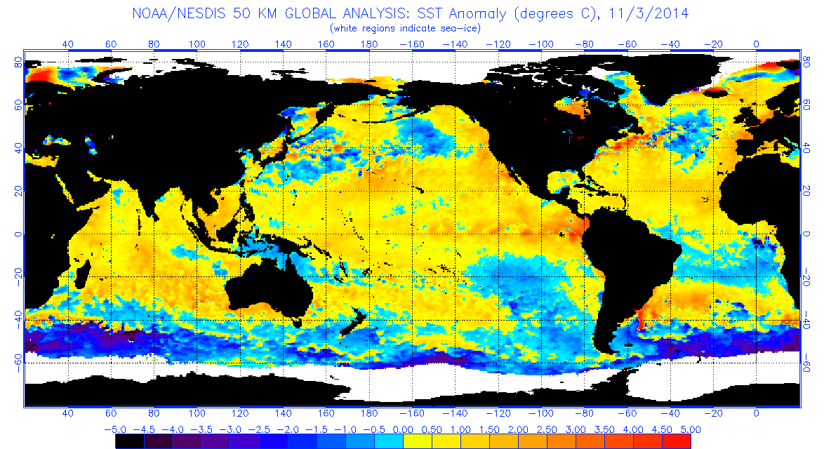
Yea, 2013-15 period featured a pretty nasty +AO/NAO but the Pac doesn't really drive the high latitudes as much as it drives the longwave pattern in the mid latitudes so jumping to the conclusion that the similarities to 13&14 means the AO/NAO are going to suck is a mistake. Current ens 5 day mean height patterns look a lot like Nov 2014. I don't think all of this is coincidence. If current ens guidance is correct, at least a portion of Nov will look very similar to Nov 2014. Looking at the GEFS panel below you can see how nice the Pac is setup to continue the trend towards a +PDO. If this is the dominant pattern in Nov then the npac SSTA configuration is going to look very good.


Still a month out from game time but you can't help but to think that the Pac/NA pattern will likely feature a coupled -EPO/+PNA at times this season. 2014 looked great in Nov and fell completely apart in Dec but no 2 years are ever the same. Not to mention that Dec 2014 was only a relaxation before the same pattern as Nov set up and carried through all the way into March. I can visualize the possibility of getting a favorable Pac/NA pattern similar to the 2013-15 stretch but what could really make it interesting is if the AO/NAO are also more favorable instead of the complete opposite of what we want to see.
Analogs are good tools to use but where people make the biggest mistake is assuming the same outcome as a previous analog. The atmosphere is way too complex to work that way. Take 13-14 for example. The mean height pattern through met winter was uncannily similar to 93/94. But sensible wx was MUCH different in our yards. Instead of a mix/icy redux of 93/94 we ended up getting snowed on start to finish. Personally, I'd MUCH prefer NOT to get a 93/94 or 13/14 upper level pattern redux because it's not a good pattern for our region to get snowfall even though one of those years was prolific. However, give me a 13/14 or 93/94 redux with SOME semblance of a -AO/NAO and I'll root for that all fookin day.
Hi Bob. I have a question. Did we have a positive IOD in 13/14 and 14/15 winter like we have so far? I am wondering why after November 2014 it warmed up dramatically until end of January 2015.
-
5 hours ago, Carvers Gap said:
My first semester at UT. Pretty much froze. Second semester, I think the opened the outdoor pool in like January. LOL.
Just seems like right now that the trough really wants to go into the East. Really pulling for that November -> winter correlation to work out. Great start here for a cold month to be realized.
Carver, i think people would want it to be cold during winter. Shorter wavelengths can allow it to be colder, but we will see if the longer wavelengths allow that or not.
-
I will say that people who think it will be warm this winter may not like cold weather. Or perhaps skeptical over last winter, which makes sense. I think most want a cold active winter. Its been a while.
-
1 hour ago, jaxjagman said:
Put the low like the GEFS shows the PDO will certainly get warmer and not cooler..just saying
Hi jax. I ain't no weather expert like most on here, but i feel like this pattern COULD last until March. Too many things that point that way. Not wishcasting, just being real lol. Now, if things shift, which is possible, then all bets are off.
-
3 hours ago, Carvers Gap said:
Definitely agree with the mid-month potential for a warm-up in our forum area. Mentioned that earlier in the week(this past week) before the ensembles went stone cold. LOL. The EPS does show some signs of a ridge late in the run in a fairly significant break from continuity. It has been wrong about those so far, and its d10-15 runs have not verified well in terms of missing cold. But with what is shown on the operationals...nowhere to go but up as the Euro deterministic is almost BN for the length of its run at TRI. The 12z Euro has extreme BN temps over portions of the Plains and southern Canada(bitterly cold) late in its run. Average high at TRI is 63ish for early November. No idea if that run verifies...but that is a chilly run.
Carver, Anthony Masiello mentioned about a sea of okhotsk low not going anywhere soon and it just popped up based on him.
-
1
-
-
1 hour ago, jaxjagman said:
You put alot of insight in your forecast,i really respect this,you could be right.But the IO shows signs which i thought the IO might die out but seemingly will get even possibly stronger.I still would like to see if the MJO is nothing but noise and see if a Kelvin will initiate around east or west of the IDL upcoming with seemingly still a WWB upcoming.Either way this is going to effect the ENSO around the IDL and east upcoming into the 2nd week of Nov and beyond

Jax, i have a question. Wouldn't it be preferred to have the warmest anomalies from the central Pacific west from there for winter? I dont think we want to see the 1+2 region warm up to much. Hopefully it dont happen. Would you say its still a little early to make a prediction for winter now or do you have a good idea?
-
6 hours ago, Typhoon Tip said:
Ok, let me ask you something ... what happens if we apply a subtle correction to atone for the Euro bias?
Thing is, it would not take much to get the flow down stream N of the Lakes into a confluence with that arm of polar high extending east of the initial -EPO load. Beyond D6 ..
I dunno man that's dangerous look for the whole U..S actually. Lots of possibilities there.. I mean I get it it's hard maybe to see outside that box but the model was too far west with this pattern change; how could we forget. We said the Euro could be too deep in the SW several times. Well..
One thing I will note..the flow is fast - let's not forget that. Embedded impulse works ( not that anyone said otherwise ) are liable to be an open wave bottle rocket variety.
Hi john. I am from Arkansas. I have a question. What do we need to see take place for the flow to slow down from being so fast like you have mentioned many times so far. Is it a -nao or more than that?
-
50 minutes ago, Carvers Gap said:
Forgot about that. LOL. Yeah, that is really pretty wild. If that cold verifies, it would be almost a carbon copy in terms of September, October and early November for much of the forum area. I mean '54 has to run out of steam at some point, right?
Carver, this is what i am confused about. The IOD is pretty positive now. I know it will weaken eventually but from what i have read that phase allows the mjo to be in niño phases, which are 8,1, and 2. Those are usually colder phases east of the rockies i think during winter. There are other factors also. Why are people going warm for this winter? Is it climate change affecting their decisions i guess? Imo HM is the best in the business. If he cancels winter, then its time to give up lol.
-
When you do your outlook, try to include the positives and negatives going into winter if you dont mind. Hopefully its colder than last winter.
-
1 hour ago, donsutherland1 said:
With persistent drizzle and light rain, New York City has picked up 0.04" precipitation today. That brings the year-to-date total to 43.36". As a result, 2019 has moved past 1992, when 43.35" precipitation was recorded, to become the 83rd wettest year on record. Records go back to 1869.
Hi Don. Wanted to first off say i respect you as a weather knowledge person. I appreciate your time and dedication to the forums. I do have a few questions. What is your confidence level on a warmer than average winter? I am still hearing varying opinions from very respected weather professionals, like yourself. Its still a little early to really know, but you may have a good idea. Not sure. I hope its not like last winter, which started off good, but ended really warm. Also, what would be the most realistic analog unless its still too early to even guess.
-
2
-
-
1 minute ago, Carvers Gap said:
Nah, I was just joking around. We actually have decent accuracy in the forum from several folks. My “hobby specialities” are the 2-4 week time frame...and NE TN snowstorms. I enjoy the pattern recognition stuff. I got into this hobby though just wanting to know snow accumulations for my backyard. However, last November was not a good one for me. I do think we want November to have some cold shots and be BN, even if slightly. John has some very good data correlating cold Novembers to cold winters. Didn’t work last winter, but still is a generally good indicator. As for knowing what will take place, I think there is some skill involved and some good fortune. But hey, we make our own luck often times. What makes this interesting is not knowing what will happen...basically making sense of what looks like chaos. The ENSO pattern right now does tell us some important information as do some other indices such as the QBO, MJO cycle, solar, and IOD. Biggest thing is seeing where the storm track(s) sets up during November and what the 500 pattern is. We are now at the time of year where the atmosphere might give us some clues. There are some rumbles of the NAO turning strongly positive. That might be a long term problem if it flips right now. Things like that.
Carver, i thought the way November started and first half of December it would be a legendary cold winter lol last winter, but I guess i was incorrect. I live a little further west than you, but it may not make that much difference. Do you think 13-14 is even a possibility for winter?
-
3 hours ago, griteater said:
Cooler trend for November east of the Rockies on the latest runs of the CFS

Griteater, i have paid Attention to you for a while now and you seem to be very astute with your weather knowledge. When will you post your winter outlook?
-
4 hours ago, Carvers Gap said:
Me predicting warmth in November is the signal for the Euro/EPS to flip cold on the very next run...I am fairly sure of that.

Carver, nobody really knows what will take place. Imo, by mid to end of November we should have a better idea of what may happen. I dont know if we want it cold or warm in November lol.
-
7 hours ago, frd said:
From bluewave, and this is pretty remarkable.
I hope to see some sort of reshuffle down the road that has some staying power.
From bluewave 's recent post :
<<<<<.
We just need some help from the Pacific. The -PNA/SE Ridge combo has been running the table this year.
2019 pattern to date

>>>>>
Is it going to take big changes to get things the way we want them for winter? If it is, then i guess we got time, which is good for us i suppose. The qbo and the IOD has me most intrigued.
-
5 hours ago, Carvers Gap said:
FWIW, the d10-15 EPS is pretty cold....time will tell.
Carver, i am not sure its a good thing to see it real cold this early. I live in Arkansas, but that may not make any difference. It was cold last November and in 2011 and the following winters blowtorched. Alot of interesting signs already.
-
1
-

Tennessee Valley 2019 Fall Speculation/Forecasting
in Tennessee Valley
Posted
Carver, im intrigued about the possible SSW event. Last year it didnt propagate correctly. They are tricky. Would the teleconnections do dramatic things if the SSW is the real deal? I was curious about that.