

Prospero
-
Posts
1,162 -
Joined
-
Last visited
Content Type
Profiles
Blogs
Forums
American Weather
Media Demo
Store
Gallery
Posts posted by Prospero
-
-
3 minutes ago, Calderon said:
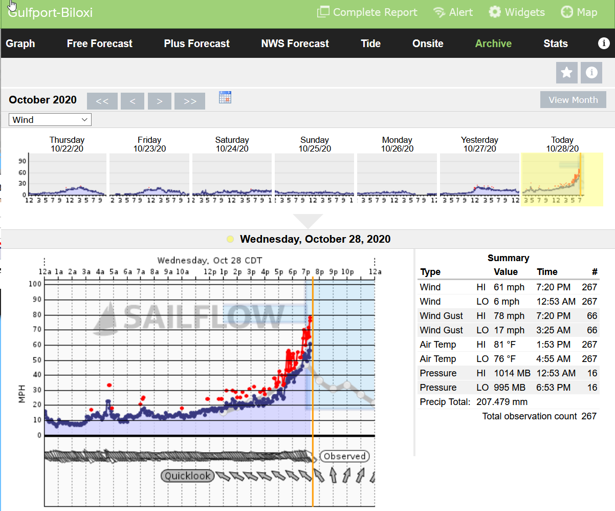
Surge now coming over much of Hwy 90 in Biloxi. There's that fast water rise they've all talked about.
Winds are increasing there. Zeta is packing a punch.
-
 1
1
-
-
Tornado?
-
We might get a week or two before the next LA hurricane...
-
1
-
 2
2
-
 2
2
-
-
How a drive across the Pontchartrain Causeway?
-
6 minutes ago, eyewall said:
Apparently media states a 108 mph gust reported in NOLA.
Few minutes ago:

-
8 minutes ago, Amped said:
It also got onshore fast and didn't build up hours of suspense. I like watching storm chases that just cut to the chase.
And I'll get to sleep at a reasonable hour tonight...
-
Seems like a treat for it to be still daylight during landfall. One of the better storms to watch this season.
-
6 minutes ago, the ghost of leroy said:
An actual wx station reading 94 sustained is pretty impressive for a cat 2
At least the rain is not much of a factor.
-
1
-
-
6 minutes ago, LibertyBell said:
what time is high tide?
10:37 pm
https://tidesandcurrents.noaa.gov/noaatidepredictions.html?id=8761724&legacy=1
The wind has shifted in the past 30 minutes or so. It was coming almost in straight in but now from the right. I do not know the direction of the cam. The water has gone down quite a bit.
https://irgir.click2stream.com/-
1
-
-
4 minutes ago, Moderately Unstable said:
Holy ****.
Lot of erosion already. The landscape is changing quickly in front of this cam...
EDIT: It is low tide right now, and whew, it is rising fast.
-
Grand Ilse cam is impressive with waves now over the dunes. A big difference from an hour ago.
-
 1
1
-
-
1 minute ago, cptcatz said:
Is that normal? I haven't been tracking hurricanes long but it seems like every hurricane this year had an open/weak south side as it moved north onto the gulf shore.
Could be the location of the radar not giving a full picture.
-
1
-
-
1 minute ago, the ghost of leroy said:
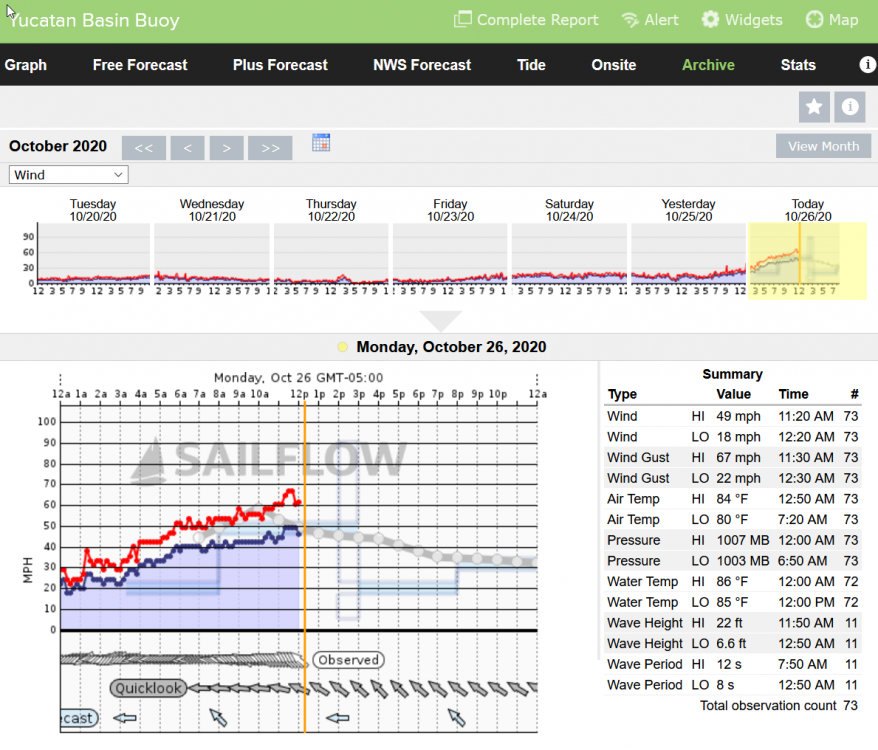
I saw that earlier. Anyone an expert on near shore wave heights? I saw the associated graph and it looks so extreme that I wonder whether it is an instrument error.
Watching the webcam posted earlier on Grand Ilse. The waves are starting to crash over the dunes and water is rising quickly.
https://irgir.click2stream.com/
-
3 minutes ago, the ghost of leroy said:
The levees will probably be fine but referencing what they are designed to handle or have prevented before doesn’t seem like the way to go. If they do fail it will not be because of their specs, it will be because of an unknown defect. Our infrastructure sucks. Something could fail unexpectedly just like Katrina.
Not sure why "Capital One Building" keeps popping into my mind...
-
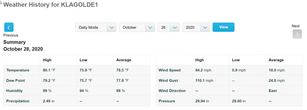
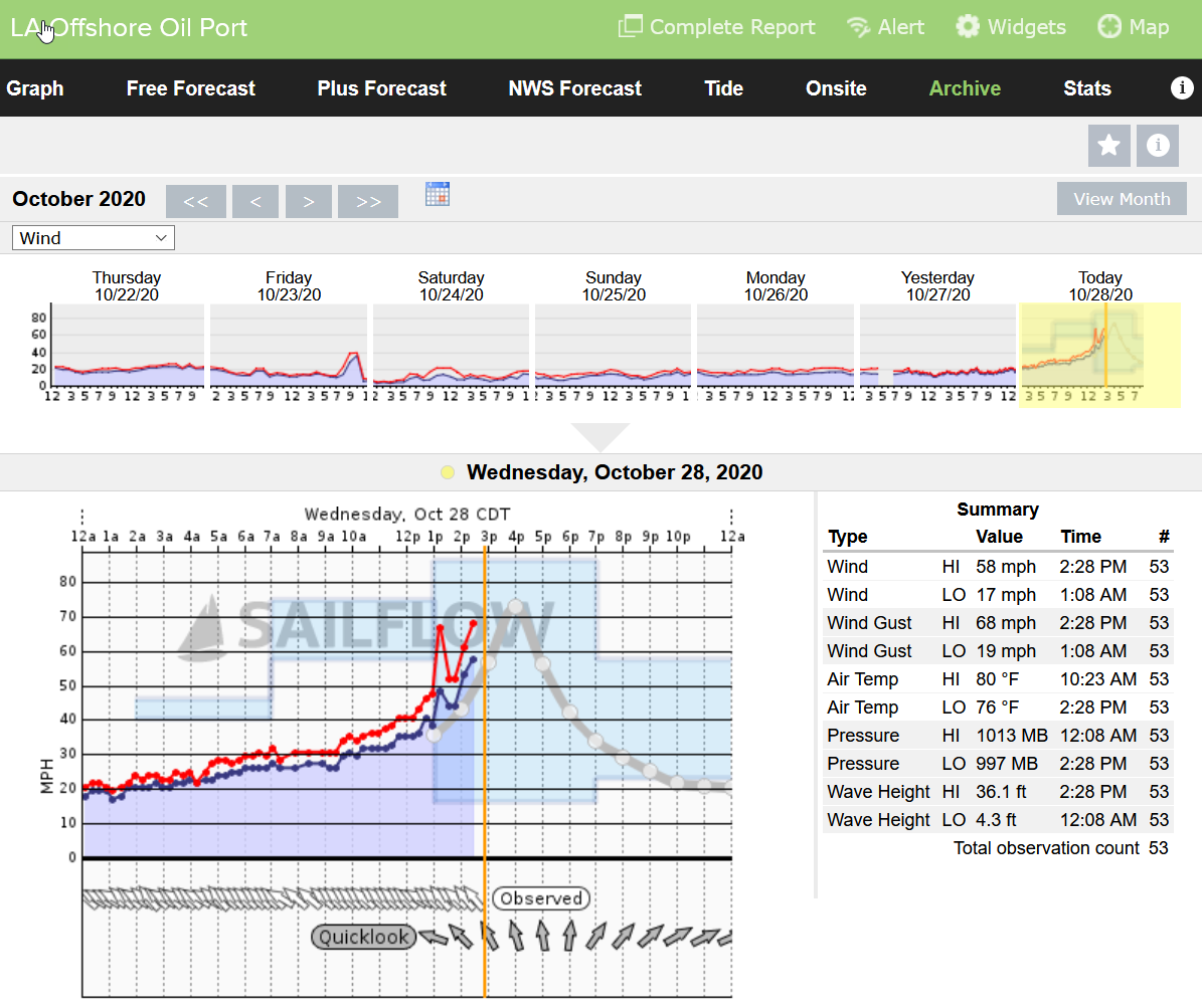
Looks like LA Offshore Oil Port just went offline. I think most in the area have dropped in last 30 minutes or so.
36.1 ft wave height. Whew, wonder how that will translate with any storm surge.

-
36 minutes ago, PSLwx said:
Has Atlanta ever been under a Tropical Storm Watch before?
I think Irma was the first Tropical Storm Warning.
Edit: "Breaking News: Hundreds of Storm Chasers descend on Atlanta to film Tropical Storm Zeta approach Atlanta!"
Party!!!
")
-
2
-
-
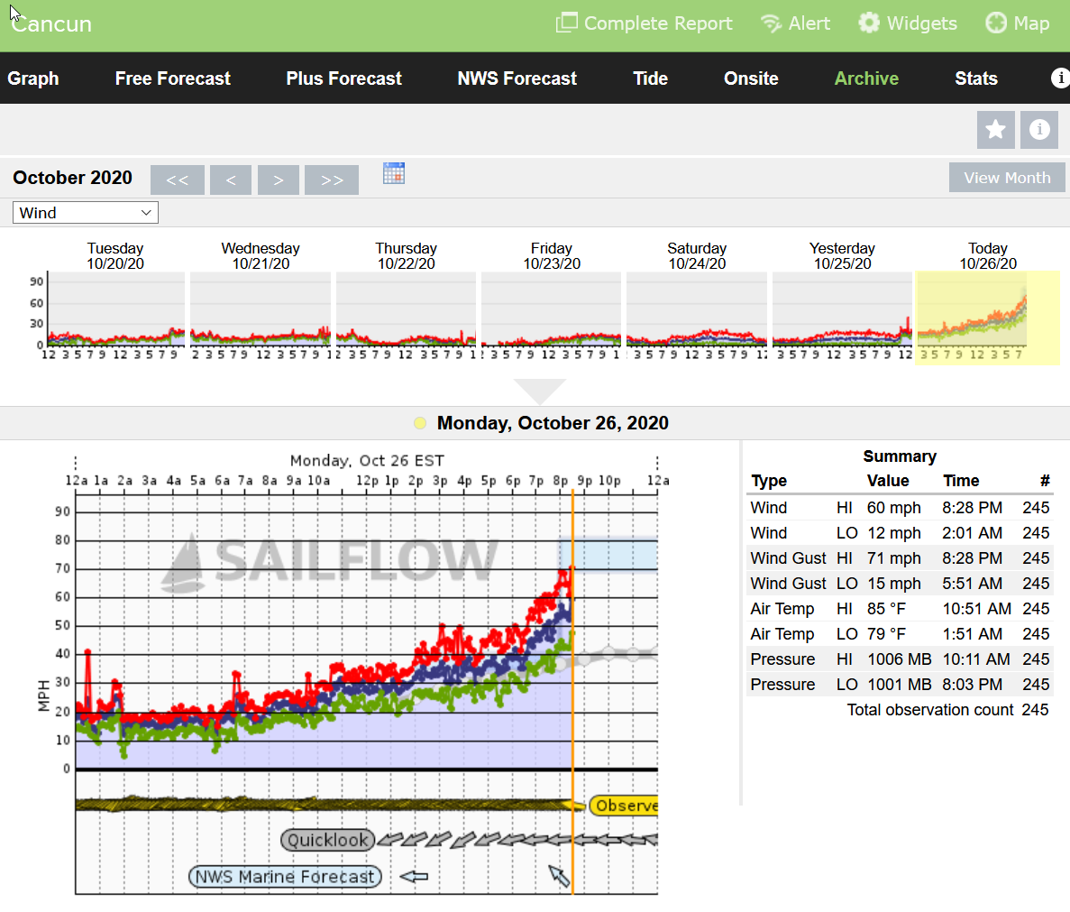
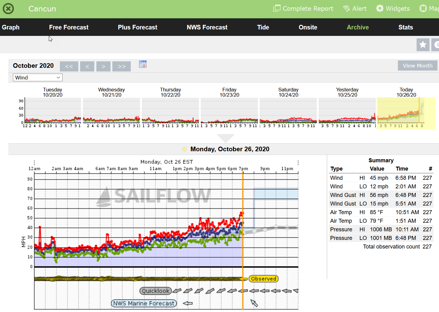
Cancun with 60 mph winds and a 71 mph gust (84/106 with Delta). That is enough to cause problems in Florida for sure.

-
1
-
-
Sitting here in Gulfport, Florida right now we are enjoying a very warm (frog strangler) strong thunderstorm that came in from the south in very late October. Usually this time of year it is dry as a bone and the only rain we might be lucky to get is from cold fronts that come through from the north. It has been muggy as heck this week, even taking showers outside to cool off as it has been so hot.
Not a typical year at all, but it IS 2020...
What will the next few weeks bring??
-
54 minutes ago, Windspeed said:56 minutes ago, Prospero said:Where can I find a path history to see any zigs and zags. My storm follower amateur eyes have thought I've seen some, but so far do not have path history in my small bucket of visual tools to look at.
Just going on the elongated minimal pressure obs from recon and their veer to the center point of that CDO feature. At any rate, it's looking like Zeta is going to run out of ocean surface before it can go bonkers, which is a good thing.
Landfall south of Delta and a lot weaker, which means more time over the Yucatan before moving back over warm waters?
(May not be adding anything to a met discussion, but there are a lot of us who check out this forum and love the technical met secret codes who are here for the sake of being with like minds.)
TS conditions in Cancun, but hopefully not too much more. Still a storm to watch for we who are totally obsessed...

-
1
-
-
29 minutes ago, Windspeed said:
Almost looks as if there has been another vortex realignment.
Where can I find a path history to see any zigs and zags. My storm follower amateur eyes have thought I've seen some, but so far do not have path history in my small bucket of visual tools to look at.
-
Quote
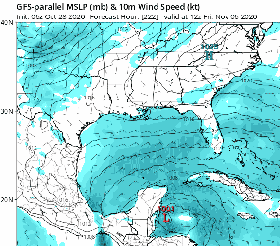
000
WTNT33 KNHC 262041
TCPAT3

BULLETIN
Hurricane Zeta Advisory Number   9
NWS National Hurricane Center Miami FL       AL282020
400 PM CDT Mon Oct 26 2020

...ZETA EXPECTED TO BRING HURRICANE CONDITIONS AND A DANGEROUS STORM
SURGE TO PORTIONS OF THE YUCATAN PENINSULA...
...HURRICANE AND STORM SURGE WATCHES ISSUED FOR THE NORTHERN GULF
COAST...


SUMMARY OF 400 PM CDT...2100 UTC...INFORMATION
----------------------------------------------
LOCATION...19.5N 86.0W
ABOUT 90 MI...145 KM SE OF COZUMEL MEXICO
MAXIMUM SUSTAINED WINDS...80 MPH...130 KM/H
PRESENT MOVEMENT...NW OR 305 DEGREES AT 10 MPH...17 KM/H
MINIMUM CENTRAL PRESSURE...981 MB...28.97 INCHES
...
DISCUSSION AND OUTLOOK
----------------------
At 400 PM CDT (2100 UTC), the center of Hurricane Zeta was located
near latitude 19.5 North, longitude 86.0 West.  Zeta is moving
toward the northwest near 10 mph (17 km/h).  A northwestward motion
with some increase in forward speed is expected over the next day or
so, followed by a turn toward the north Tuesday night. A faster
northward to north-northeastward motion is forecast on Wednesday. On
the forecast track, the center of Zeta will move over the northern
Yucatan Peninsula later today or tonight, move over the southern
Gulf of Mexico on Tuesday, and approach the northern Gulf Coast in
the watch area on Wednesday.

Maximum sustained winds are near 80 mph (130 km/h) with higher
gusts.  Some additional strengthening is possible before Zeta makes
landfall in the Yucatan Peninsula.  Some weakening is likely while
Zeta moves over the Yucatan Peninsula late tonight and early
Tuesday.  Zeta is forecast to strengthen again when it moves over
the southern Gulf of Mexico later on Tuesday and be at or near
hurricane strength when it approaches the northern Gulf Coast on
Wednesday.

Hurricane-force winds extend outward up to 25 miles (35 km) from the
center and tropical-storm-force winds extend outward up to 115 miles
(185 km).

The estimated minimum central pressure is 981 mb (28.97 inches).
-
1 hour ago, Cheeznado said:
Big question is how much strength it loses as it will spend a fair amount over the Yucatan, both the HWRF and HMON have it back down to a TS and never really bring it back to a hurricane.
Delta passed over quickly. If it's eye and structure held together the end game would have been much worse. Granted almost a month ago, the Gulf has cooled a bit.
-
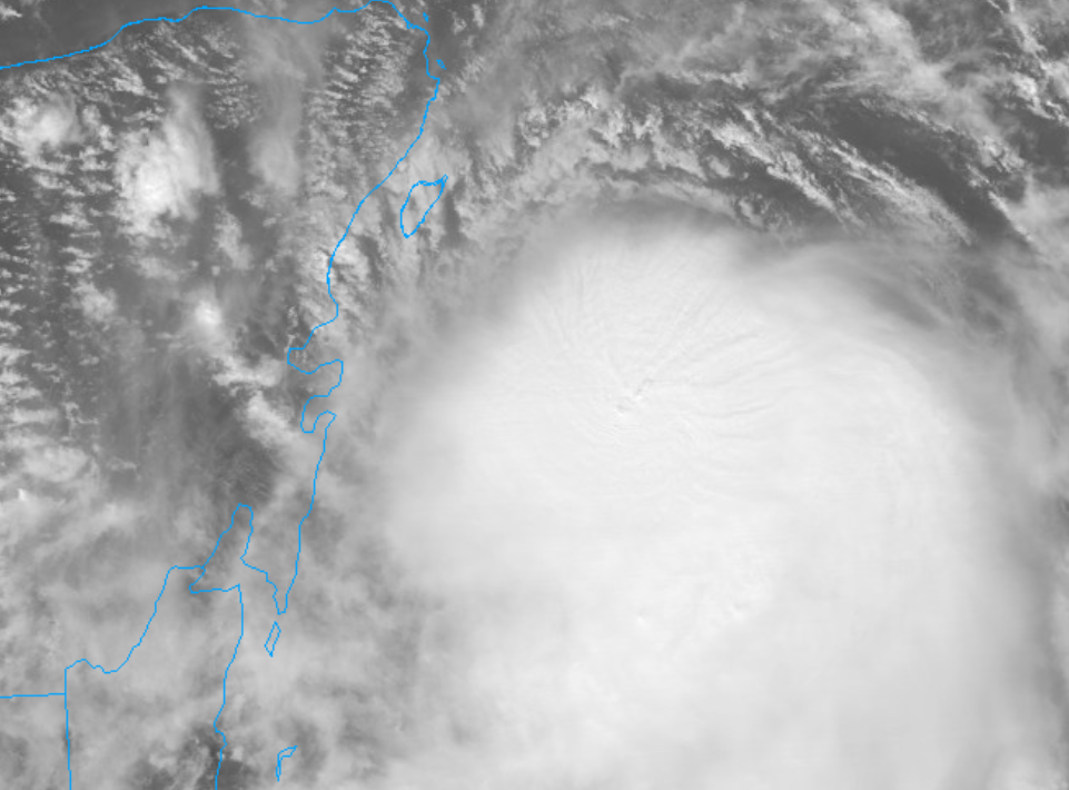
Some nice patterns coming from the center of the convection:
-
No radar, but we do have a few anemometers to watch.
Kind of makes me want to fly into Cancun and rent a car to drive around in the approaching storm...
")

Hurricane Zeta
in Tropical Headquarters
Posted
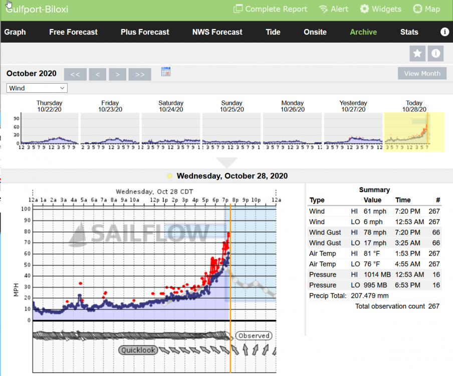
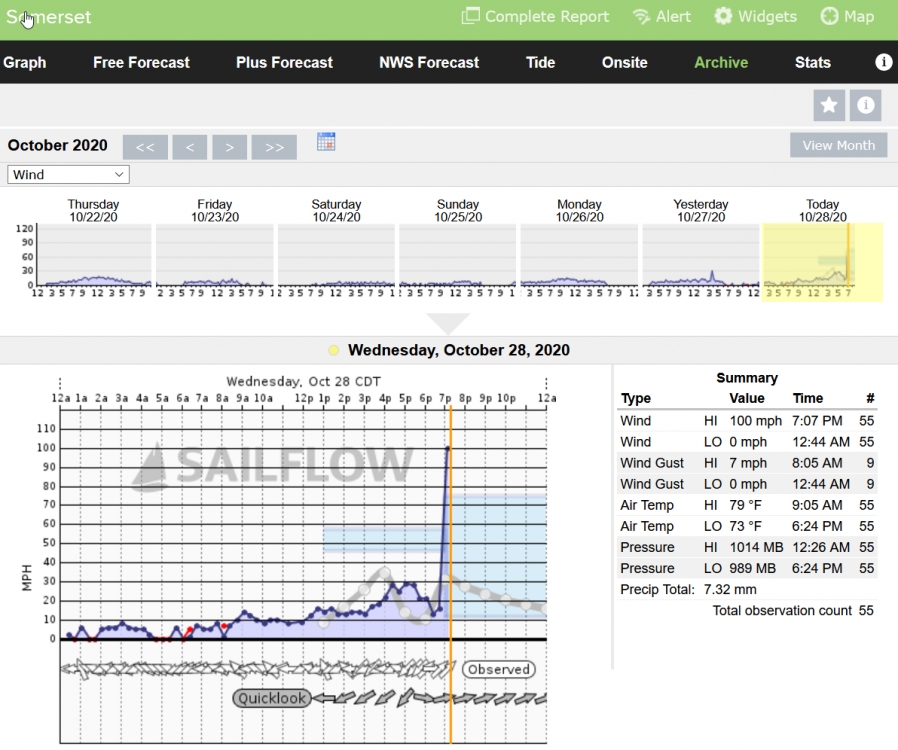
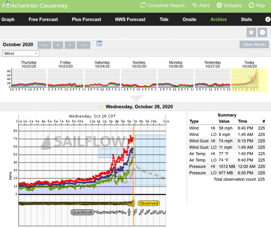
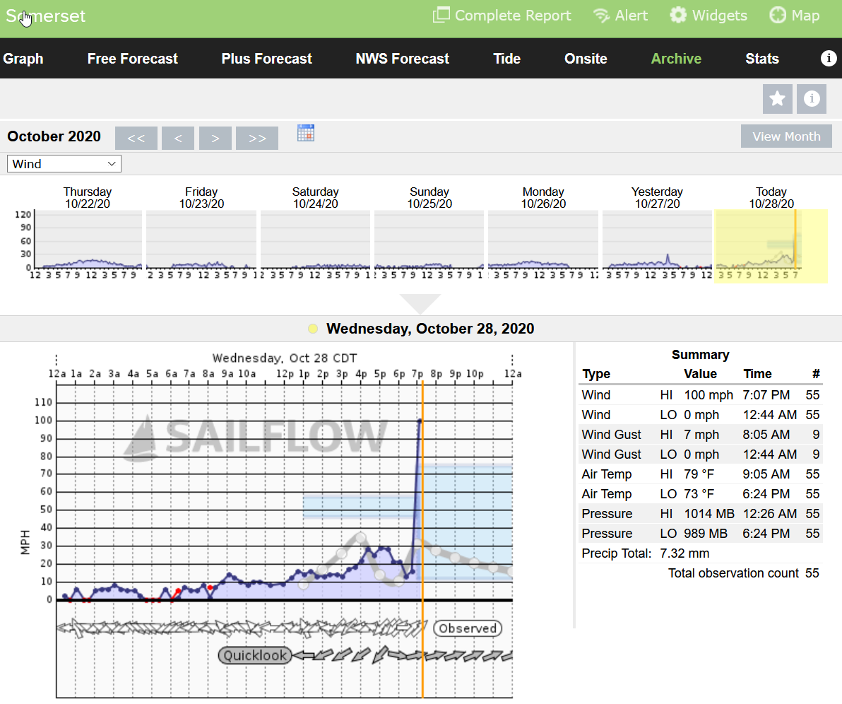
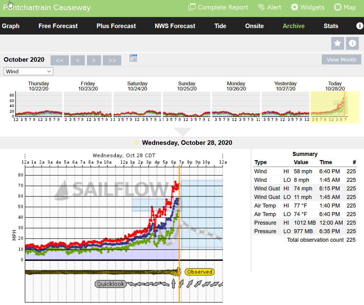
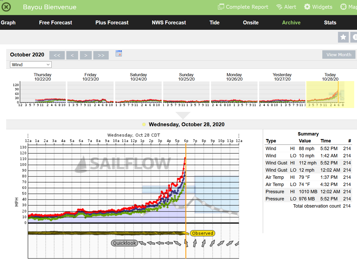
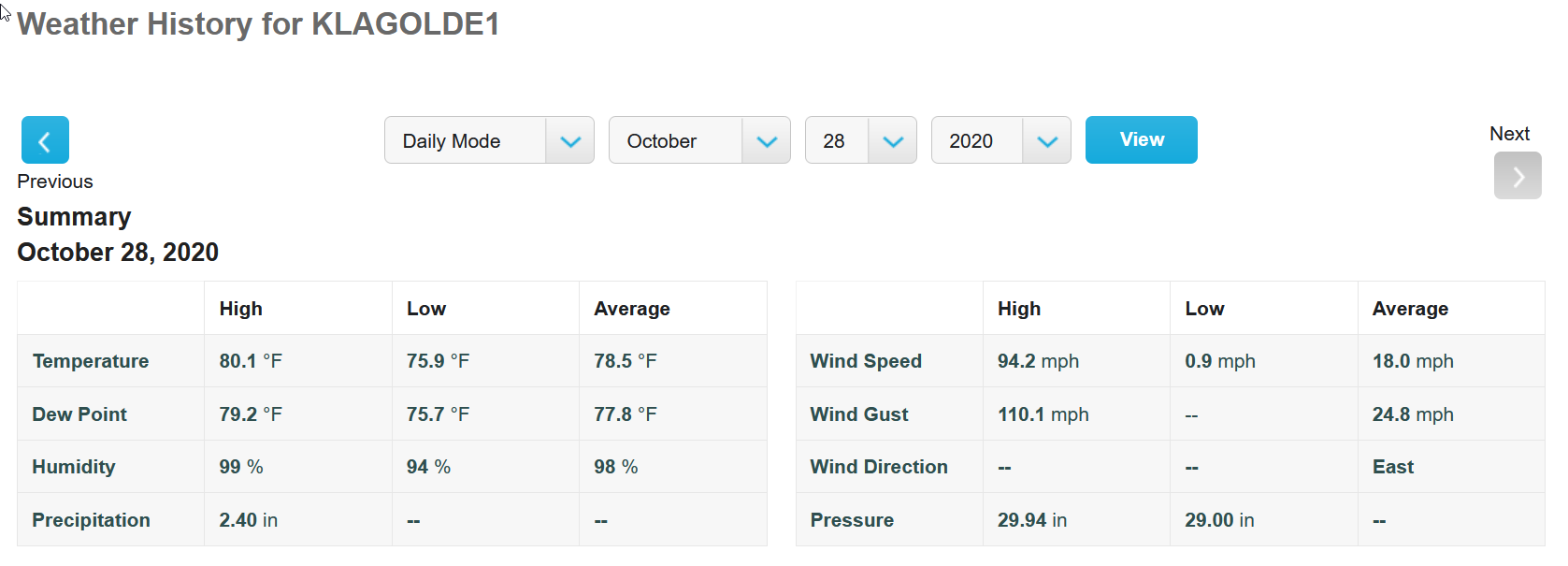
Some decent wind and surge footage: