

Prospero
-
Posts
1,162 -
Joined
-
Last visited
Content Type
Profiles
Blogs
Forums
American Weather
Media Demo
Store
Gallery
Posts posted by Prospero
-
-
Seems like it has been a long off-season, even though it has not been that long. At least now its fun to look at models every day and be back watching this forum for comments. Any teasers are worth their value in excitement, even random 14 day out models that come and go. Tampa Bay has already been in a strong storm a few times in 2021 models! (That is definitely preferable to being in a real life strong storm here.)
-
Cristobal gave us over 4 inches of rain last year in Gulfport, FL on June 6th. We could sure use at least part that right now!

-
7 hours ago, Roger Smith said:
So, this year, the official contest scoring will follow that precedent just in case we go off on a bender again with every swirl of cloud getting a name. Scoring as follows:
base score 100
_ less one quarter of (error of named storms) + (error squared of named storms)
_ less one half of (error of hurricanes) + (error squared of hurricanes)
_ less one half of (error of majors) + (error squared of majors)
I love mathematical formulas almost as much as a good storm! Funny how "math" connects ALL things.
")
But I am "John Dee", Prospero of Shake-Speare/Bacon...
-
 1
1
-
-
1 hour ago, Ed, snow and hurricane fan said:
Early season IMBYism, but some support from op Euro and some GFS ensembles. Day 10 ECENS from Weathernerds. Tracking back, looks like something tries to form on the monsoon trough one side of Central America or the other...
GFS keeps popping up with storms then drops off. Our typical afternoon thunderstorms in central-west Florida are still lacking which means the moisture in the ground to feed the sea-breeze collisions is low right now and it might be a late rainy season for us if we don't end up in a drought. Of course that can change in a few days time, but not in the next week or so at least.
Could be a slow start to the TS season this year as well which only amps the energy for later on. Just a thought, based on a decades long lifetime of wish-casting.
-
Don't remember seeing a graphic like this for a few years. Maybe they changed what is normal?
-
1
-
-
OK:
14/11/7
Probably way low on named storms, but seven majors. Teresa might be one to be historic...
-
 1
1
-
-
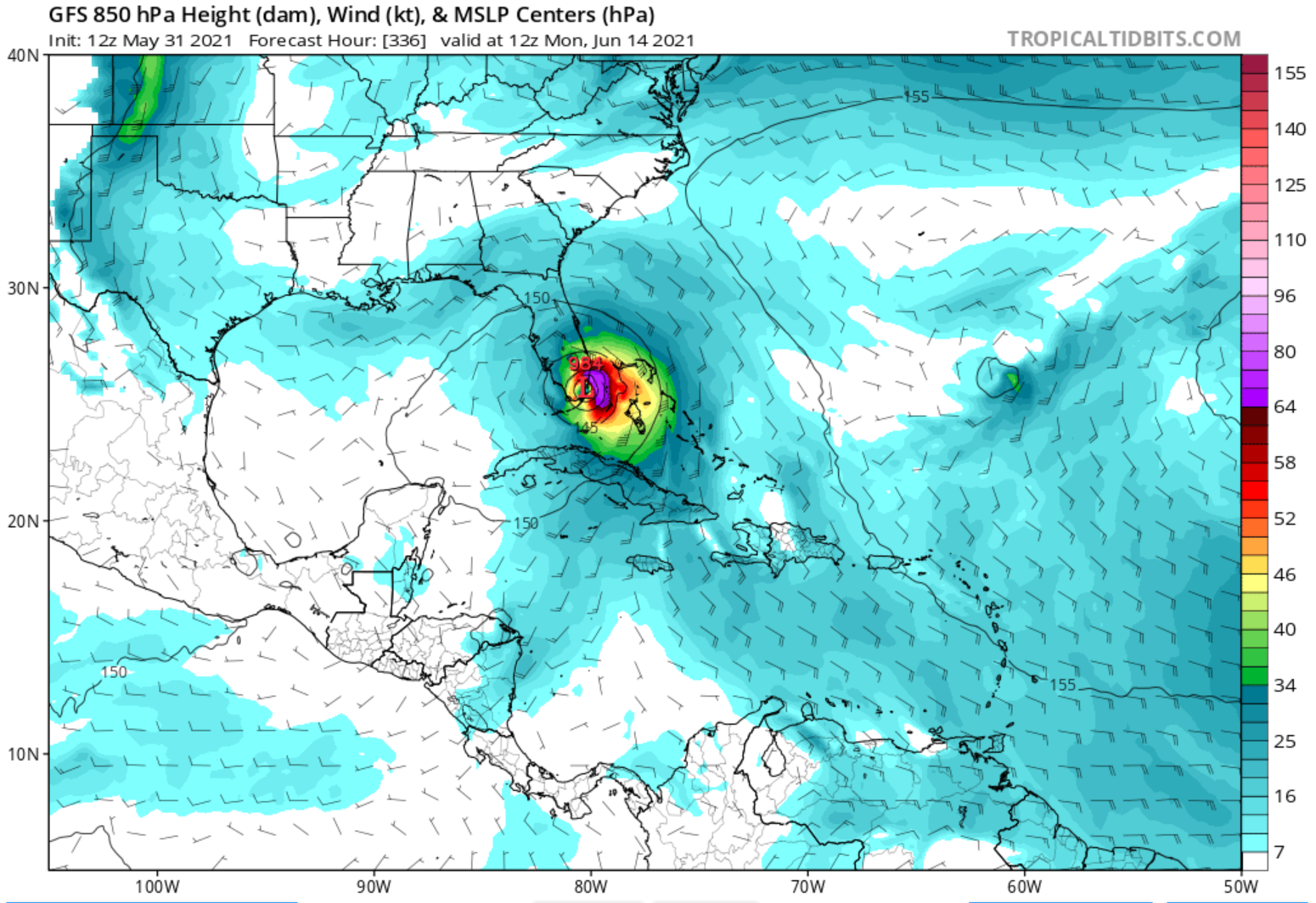
Today's GFS model:

-
Ana begins 2021, what name where it end? What name will be the one to remember?
Is "Ida" a safe bet as the name to never forget?
-
That would be nice. Forum archives are a museum for future generations.
-
1
-
-
Quote
Regardless of development, the system could produce heavy rainfall over portions of southeastern Texas and southwestern Louisiana through Saturday.
Given the complete saturation of soils with ongoing river flooding along the Texas and Louisiana coastal areas, heavy rain could lead
to flash, urban, and additional riverine flooding across this region.
Not that I am bored with TX/LA after last year, but can we get something different this year? ;)
Of course sparing the Central West Coast of Florida another year...
-
17 hours ago, JakkelWx said:
That was the craziest Atlantic hurricane season in my lifetime besides 2005. 2020
Curious what is ahead of us.
Weird to me that so many what should have been perfect eyes never materialized. Maybe that is why the ocean could not get rid of its heat?
-
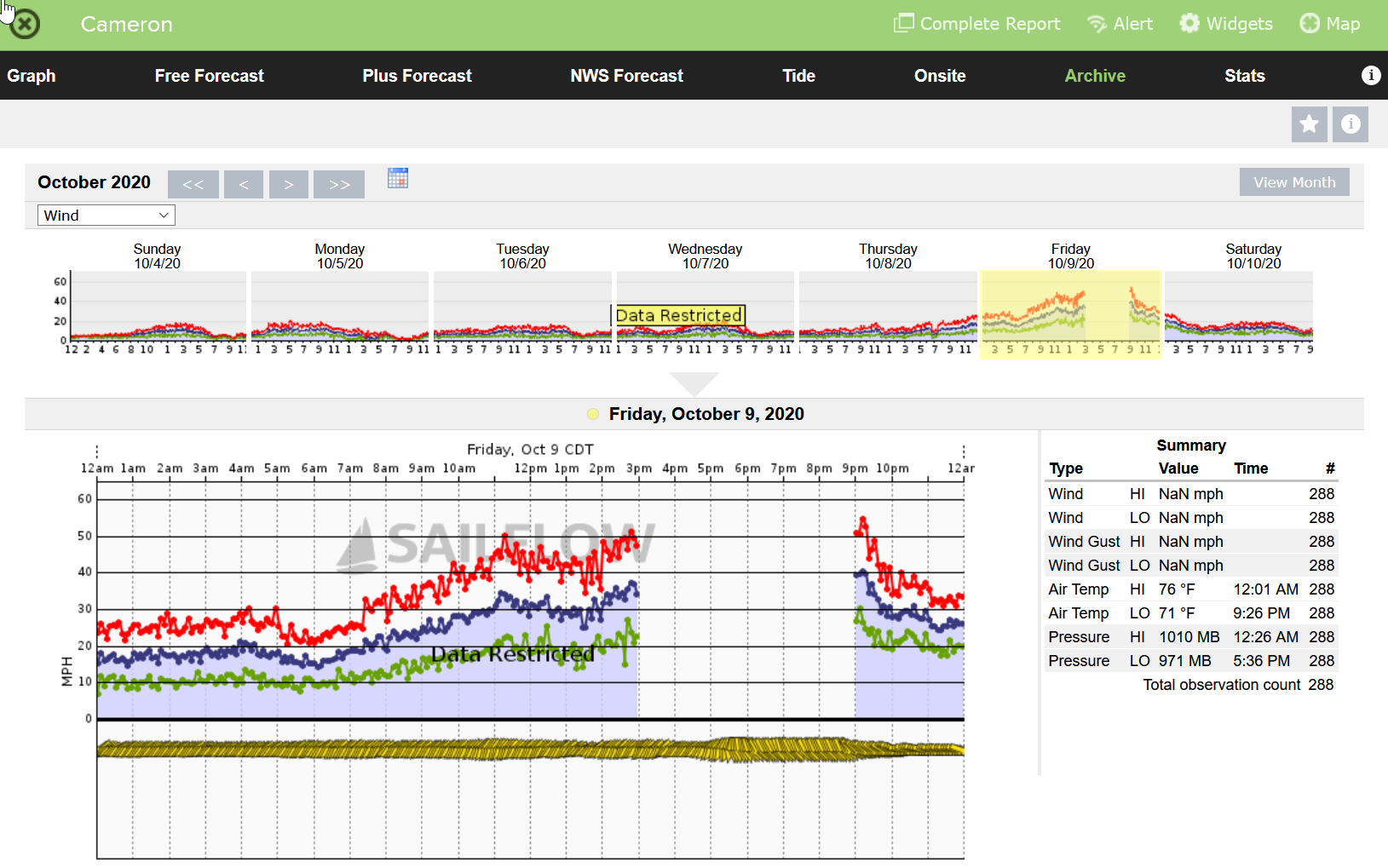
December 12, 2020:
I thought Cameron would post it's wind data by now. But no.
Does anybody have the super secret access to share what the peak winds were here? It was recorded, but who knows what Cameron experienced. They are not posting.
-
"C" has had five, but all but four were before 1960 counting 45 years of storms ("Cuba" 1924 to Camille 1969).
"I" and "M" are tied with four each within the last 22 years.
Letter "I" had four in 17 years (Isabel in 2003 to Iota in 2020).
"M" has had four in 20 years (Mitch in 1998 to Michael in 2018).
Basically from the 7th to the 14th storms of the are the ones that become Cat 5s in the last couple decades.
https://en.wikipedia.org/wiki/List_of_Category_5_Atlantic_hurricanes
-
4 hours ago, cptcatz said:
Andrew was a cat 5 but I can't think of any other A-named cat 5's meaning that's the only season that opened with a cat 5. Has any other season other than 2020 ended with a cat 5?
Allen - 1980
Andrew - 1992
Anita 1977
-
3 hours ago, cptcatz said:
Andrew was a cat 5 but I can't think of any other A-named cat 5's meaning that's the only season that opened with a cat 5. Has any other season other than 2020 ended with a cat 5?
Which makes me curious, what letters have had the most Cat 5's?
-
On 11/26/2020 at 8:31 PM, Sam Kane said:
There's a blizzard predicted around Christmas in the south similar to the one in 1993. The city of Montgomery is already planning on shipping in enough of snow plows for the city. This is crazy 2020!!!
Wonder if 2020 will bring snow to Tampa Bay. I'm always eager, missing the ski areas out west.
-
32 minutes ago, RT1980 said:
So in your opinion where is the threat coming from?
I don't see any threats looming. 2020 has been quite a year, but I am not concerned about any tropical threats right now for us.
Waiting for cold fronts to come down and give us rain now...
-
I've been saying for a few months that we in the Tampa Bay area won't consider ourselves out of the woods until Thanksgiving. Granted Eta was a visitor and I look forward to some time this week to finish cleaning up.
But maybe the season is over for us.
-
1 hour ago, cheese007 said:
40% blob now where the lemon was this morning. Unreal
I wonder, this being 2020, will we finally have a measurable snowstorm in the Tampa Bay area this year?

-
 2
2
-
-
Eta was mild for a Tampa Bay landfall, I guess. Just spent part of this afternoon still doing clean up in our yard. We were lucky. Still a pain in the behind. It was exciting to follow for such a long time though.
I was at the grocery store today. Toilet paper shelves were still mostly empty. LOL
-
1
-
-
11 minutes ago, the ghost of leroy said:
Respecting yoda

Hell, I even respect you ghost!
")
Call me crazy!
Weather is my passion, ever since before I could spell it! (No that was not HS, it was when I was 3 or 4 years old!)
Put me in a room with storm geeks and I am happy. Same with a room full of Dead Heads. Good times and a wild mix of personalities and experience.
Guess tropical discussions are almost over for the season. Will jump into blizzards next, right?
-
18 minutes ago, cptcatz said:
It would have to get over quite a ridge to make it up to the CONUS
Hope it does not change!
-
For what it is worth, the second post on the Eta forum by yoda (who has my respect):

Interesting if you go back to the beginning of the Eta thread and relive a few pages.
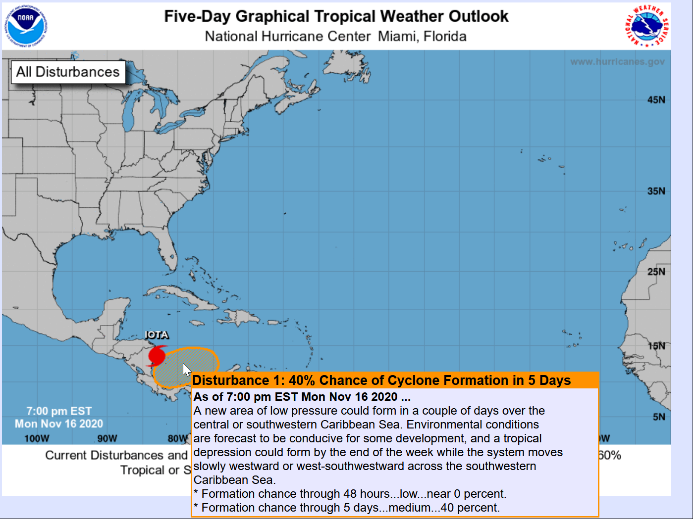
We got our 2020 storm in Tampa Bay. May Iota leave us all alone!
-
1
-
-
1 hour ago, the ghost of leroy said:
The worst hurricane to hit Tampa since 1848 was one in 1921. Of course it destroyed Gulfport as well.
I've been wishing and wish-casting a tropical storm to visit Gulfport all season. "As strong as possible without power outages, financial hardship, deaths, etc."
Well, we got it, with more financial hardship than I wished. No deaths so far. A few hundred lost power, but will be back on soon if not already.
As far as local news in the Tampa Bay area, Gulfport had the best visuals. Every local news station was in town today. Here is one link that shows pictures mostly from here:
https://www.baynews9.com/fl/tampa/weather/2020/11/12/photos--eta-s-aftermath-in-the-tampa-bay-area
I was out late last night doing last minute panic prep in our yard getting soaked in the driving rain when the winds picked up, and spent a half a day today trying to clean up our yard enough to have a path to go where we need to go. Landscapers with chainsaws will do the rest. I am physically exhausted! Too old for this stuff! My back is killing me!
I asked for it, and got it. Maybe the last US storm landfall of the season, maybe not.
Next year I might not be wishing anything here or for anybody!
Side note: I was down by the waterfront at first light this morning and very few people were down there looking at the sights. I took my wife down there a couple hours ago and all the restaurants that were flooded last night were totally packed with storm voyeurs! Crowds with their cell phones were taking pics on the beat up brand new boardwalk. Gulfport is very busy tonight! LOL
Tropical System Tourism is maybe not so bad. (Except Camille...)

2021 Atlantic Hurricane season
in Tropical Headquarters
Posted
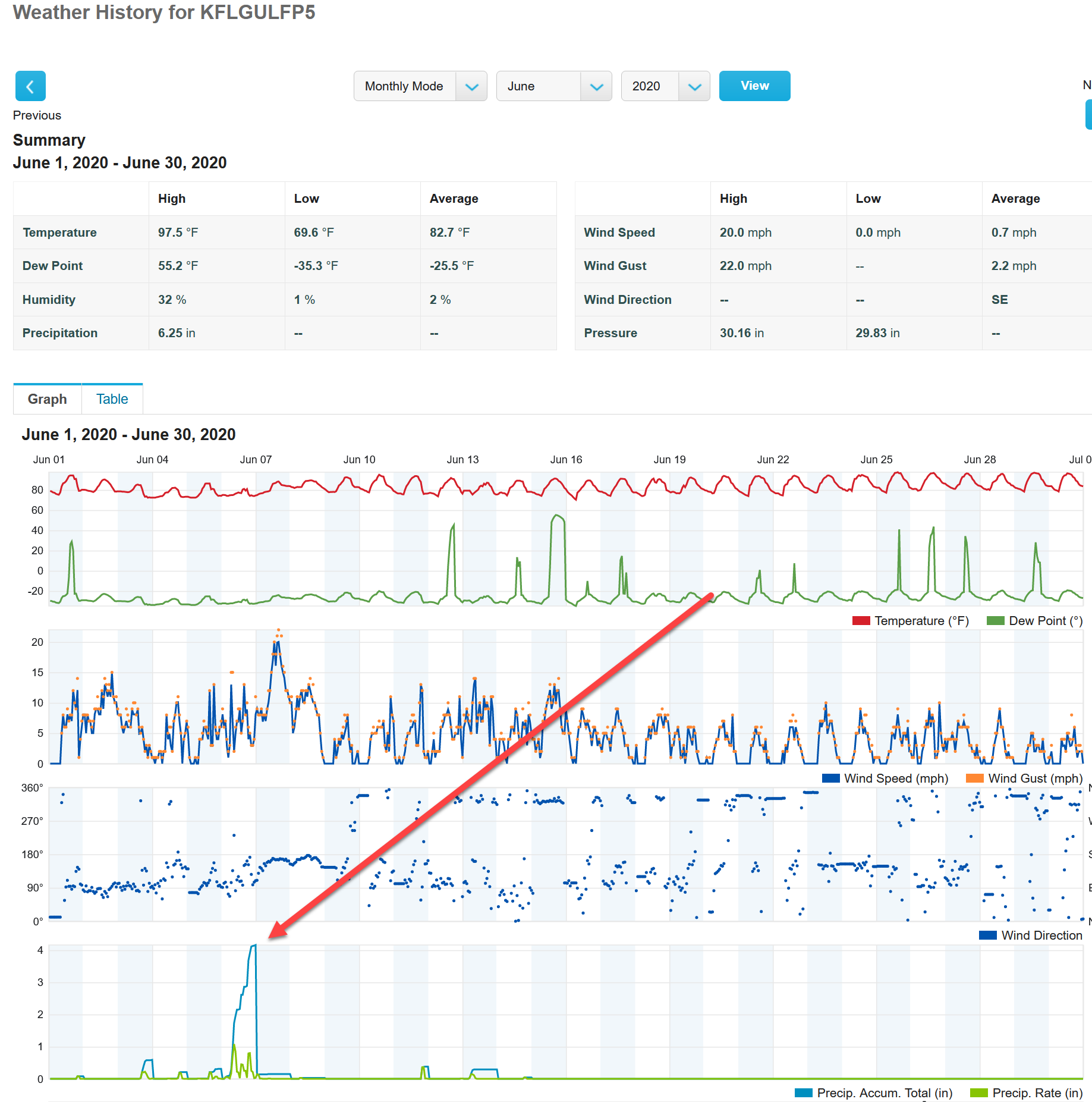
Unusual year here in Florida. Where we live in Gulfport it is not uncommon for May and June to be bone dry even when some areas of Tampa Bay and east get storms. But to be in mid-June and sit outside with low humidity is out of the ordinary. No mosquitoes, no sweating. Feels like late September, still hot but dry. Normally May and June are miserable with humidity even when the storms form over us and move inland without giving us rain. That's really not happening yet. A few thunderstorms popped over central Florida today, but not the same.
As an observer and a passionate storm watcher, we're off to a different start than the past few years. Might not have any influence as far as the the overall tropical storm season, but definitely not a typical year for us in Pinellas County, Florida with humidity and moisture.