

Prospero
-
Posts
1,164 -
Joined
-
Last visited
Content Type
Profiles
Blogs
Forums
American Weather
Media Demo
Store
Gallery
Posts posted by Prospero
-
-
33 mph gust in Gulfport, FL a few minutes ago. That's more than Imelda brought which was a very nice steady breeze.
")
I looked at NOAA and was surprised to see a lemon!
-
 2
2
-
-
Winds are picking up here in Gulfport. This is my front yard cam:
https://thegabber.com/gulfport-49th-street-south-web-cam/
-
3
-
 1
1
-
-
38 minutes ago, ArlingtonWX said:
Here is some info I found earlier today about evacuation zones in Tampa Bay region. Scroll down a bit for different jurisdictions in the TB metro area

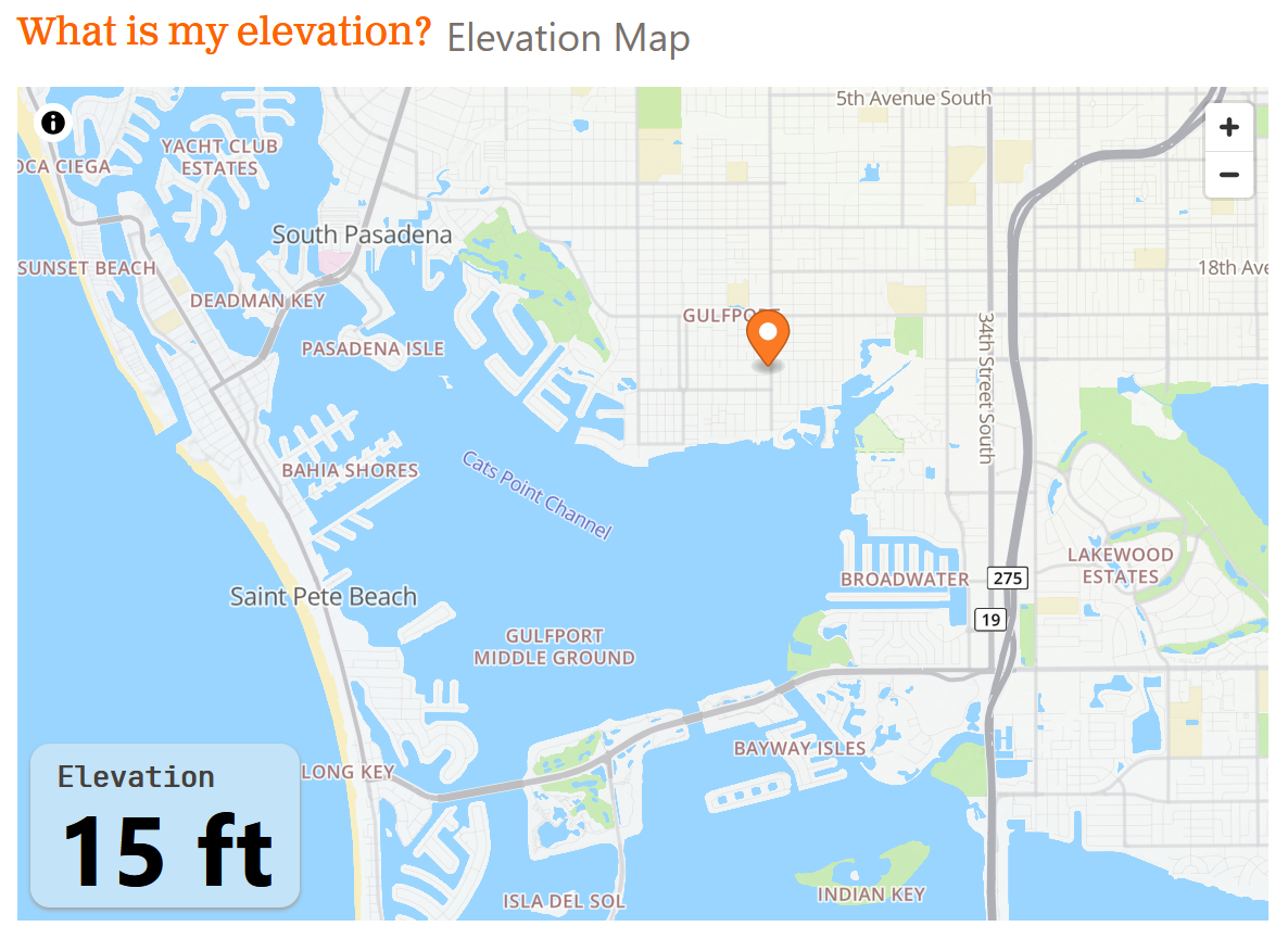
This is a very handy website to find out your elevation. It appears to be right on accurate.
https://whatismyelevation.com/map?lat=27.7443&lng=-82.6999

-
2
-
-
Just now, Windspeed said:33 minutes ago, Prospero said:Will an eye be elusive in this one?
No, sir. We should eventually see a very clear and symmetrical eye as a major hurricane while favorable conditions allow.
That will be different for a Gulf storm, until just before landfall.
")
-
Will an eye be elusive in this one?
-
10 minutes ago, andyhb said:
Yes. Anything south of the bay would mean water gets pulled out to sea from offshore flow on the north side of the eye vs. the bad scenario where it gets piled up by onshore flow in the right front quad.
If the surge is as high as it was last week with Helene, and with so much debris piled up on street after street, I assume the surge would build up during the approach to a high level sweeping up everything that is mostly small broken pieces of whatever is in those piles. If the eye passes to the south and we get strong offshore winds all of that stuff will be washed out to sea. There could be trash washing up on the beaches for a very long time.
-
Pinellas County issued a mandatory evacuation for long-term, healthcare facilities, and assisted living facilities in Zone A.
https://thegabber.com/zone-a-evacuation-begins-milton-update-5/
The Assisted Living facility where my Dad lives in Zone B is evacuating tomorrow "to be safe."
-
3
-
-
17 minutes ago, Hotair said:
And those just hit need to meticulously document with photos and videos the current state of their homes and roofs A wind event will likely be fought tooth and nail by the insurance companies who will argue for prior storm surge flood damage.
For those with older homes, if 49% destroyed will need to rebuild to modern requirements which for many places means raising the homes up which is extremely expensive.
-
1
-
-
Helene, she came with a sea-born roar,
A 6-foot surge upon the shore.
Gulfport braced, the waters high,
The tides rose up to kiss the sky.Yet rumors tell of Milton’s might,
With fiercer winds and waves in flight!
“Twice the surge!” the whispers say,
As Milton eyes his stormy prey.But hear me, friends, though winds may bite,
Though waves crash loud in darkest night,
Thy strength, like oak, shall stand unbent—
For Gulfport’s heart’s not easily spent.So huddle close and hold the line,
The sun shall break, the stars shall shine!
For storms will pass, as all things must,
And hope returns, as sure as dust.-
11
-
-
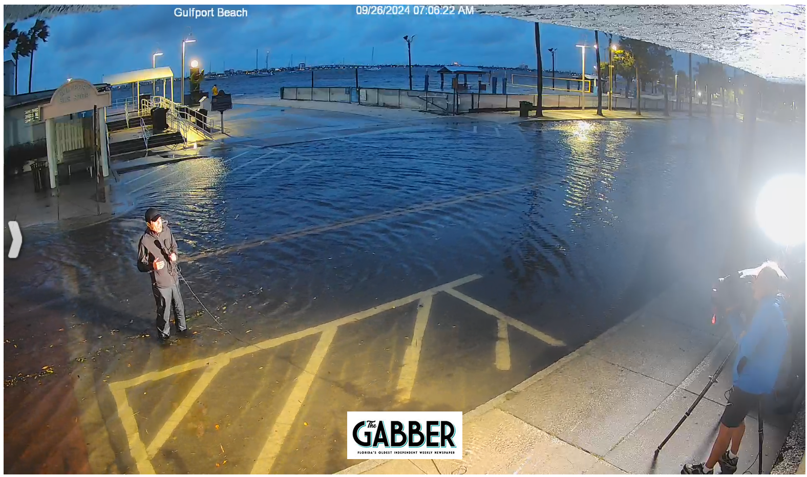
Here is a clip from 7:00 pm in Gulfport, Florida which was still over 5 hours and a few feet to high tide. This was the beginning for us.
-
 1
1
-
 1
1
-
-
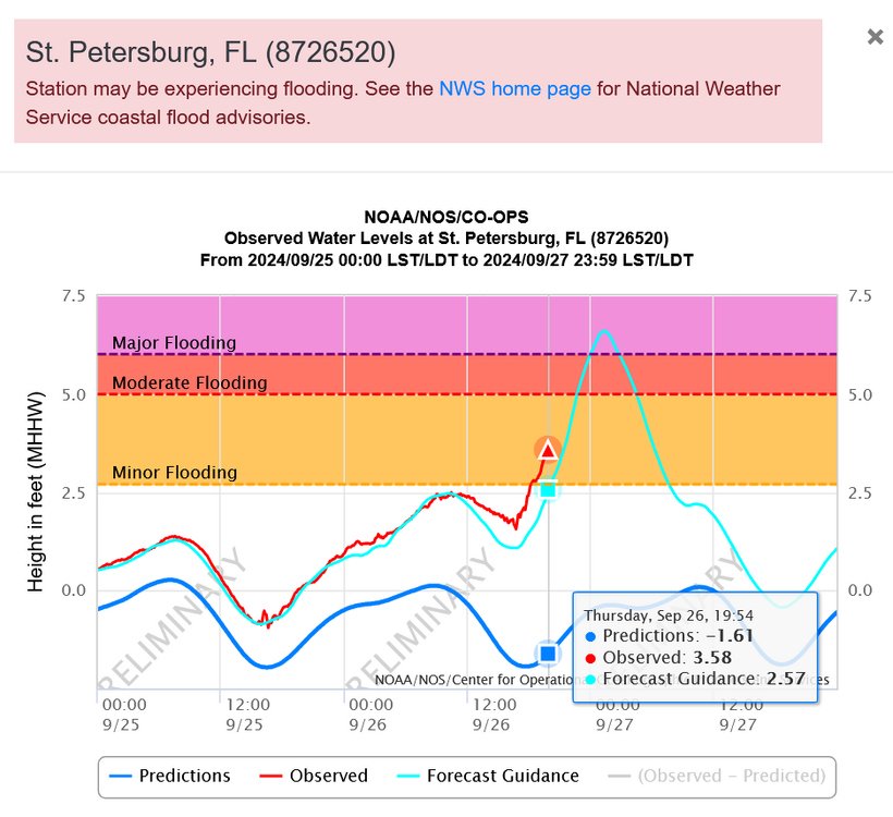
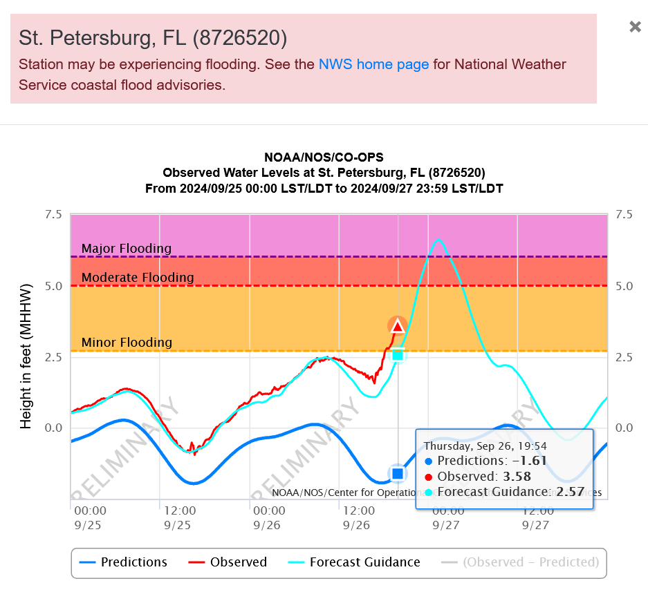
The observed tide is higher than the predicted and we have a few hours to go in Pinellas County.
https://tidesandcurrents.noaa.gov/inundationdb/cidstorm.html?stormname=Helene
-
3
-
 1
1
-
-
Structure Fire on a block downtown Gulfport that the fire department cannot get to due to storm surge. On no!
-
2
-
3
-
1
-
-
11 minutes ago, HIPPYVALLEY said:
A friend of mine is on a spit of land near Clearwater called Dunedin Beach and he said it’s getting pretty intense.
They are four stories up in a sturdy building and I’m sure they will be fine but this is when you start questioning if you should have stayed or not.
This will be remembered for a long time. I have concern for everybody in a storm surge vulnerable location. I'm at 15 feet in Gulfport and getting a little concerned even this high.
https://clearwaterbeachcams.com/
We are in for a very nasty surprise tonight in Pinellas County.
-
2
-
-
Storm surge is way past Idalia and still several hours before high tide and we are not even getting "the push" yet.
It will be pushing ten feet in Gulfport, I will bet. I have never seen a storm surge in Tampa Bay like this since I moved here in 2003.
-
1
-
2
-
-
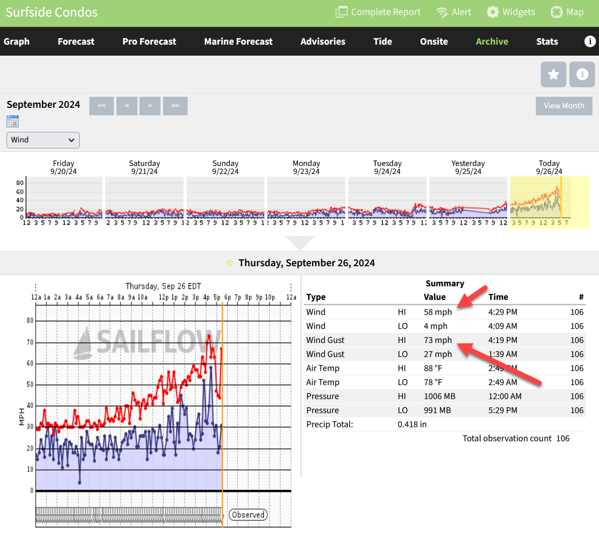
18 minutes ago, cardinalland said:
Hurricane Helene's center is approx. 100 miles from Clearwater right now. It will likely get as close as 90 miles away before it begins gaining distance as it moves toward the Panhandle.
Already solid TS force winds at Surfside Condos on Clearwater Beach and still not the strongest they will see.
https://www.sailflow.com/map#27.962,-82.745,13,1,!172594,7

-
1
-
-
24 minutes ago, Hoth said:
Siesta Key beach cam is pretty wild. Water over the whole beach and waves occasionally bumping the lifeguard stations. Glad my grandmother decided to take shelter inland.
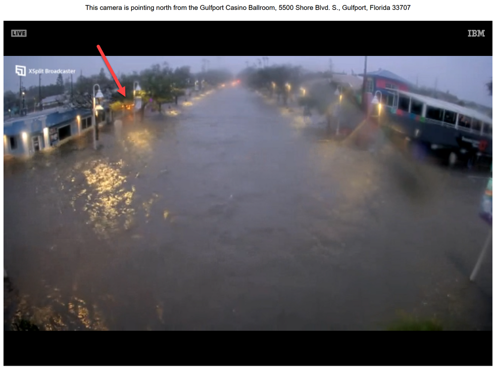
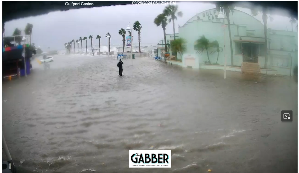
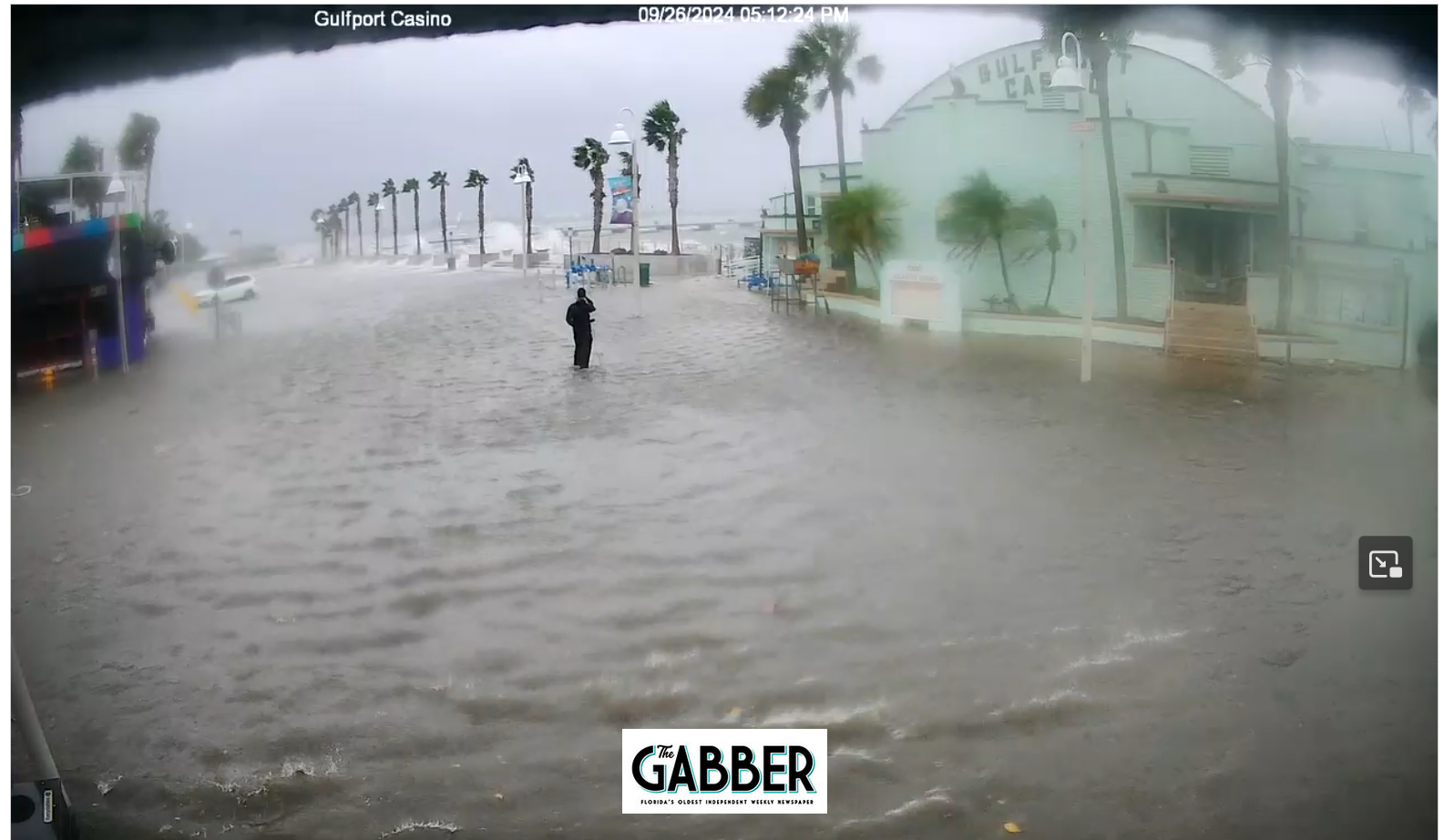
Low tide was over about a half hour ago and we have along ways to go to high tide after midnight. Already the water level is rising. Here in Gulfport we are used to seeing downtown flooded, but tonight could be the first time it will be too deep for people to wade in and around. It could be over everybody's heads in a few hours.
I notice the cameras are slow to load and that is because so many people are watching them. But after a moment or so you can see a live stream:
https://thegabber.com/gulfport-casino-web-cam/
-
2
-
1
-
-
2 minutes ago, DDweatherman said:
The efforts other than surge will be a nuisance mostly for the Tampa St Pete metro. You guys get 50-60mph wind gusts from tropical systems plenty. The biggest concern, by far in places like Gulfport and those areas will be the surge. This evening’s high tide could bring a lot of water in that area.
I have no doubts we will be breaking records tonight with the surge. I've been through enough here to recognize the signs. Downtown Gulfport and areas of Tampa Bay will be inundated beyond what we have seen before. Hopefully our cameras will stay up as long as possible. They stayed up in Idalia and Debbie even when water was inside the locations. But the winds were not that strong and electricity and internet stayed on. Tonight both could go down early.
Our home is at 15ft so we should be OK for this one. There has not been a 15ft storm surge in our area in modern history. But it is always possible...
Debris is already falling into our yard. Hold on! Woohooo! We gotta storm!
-
6
-
1
-
-
Just now, wthrmn654 said:
Hurricane Helene Tropical Cyclone Update
NWS National Hurricane Center Miami FL       AL092024
300 PM EDT Thu Sep 26 2024

...STORM SURGE AND WINDS INCREASING ALONG THE FLORIDA WEST COAST...
...300 PM EDT POSITION UPDATE...

A Weatherflow station at Egmont Channel at the entrance to Tampa
Bay recently measured a sustained wind of 50 mph (80 km/h) and a
gust to 62 mph (100 km/h).


SUMMARY OF 300 PM EDT...1900 UTC...INFORMATION
----------------------------------------------
LOCATION...26.9N 84.8W
ABOUT 160 MI...255 KM WSW OF TAMPA FLORIDA
ABOUT 195 MI...315 KM S OF APALACHICOLA FLORIDA
MAXIMUM SUSTAINED WINDS...120 MPH...195 KM/H
PRESENT MOVEMENT...NNE OR 25 DEGREES AT 20 MPH...31 KM/H
MINIMUM CENTRAL PRESSURE...959 MB...28.32 INCHES
Its not raining yet in Gulfport, FL but the breeze is quite stiff. It feels really good right now on the skin, but we know we are soon to be having a little white-knuckle ride coming up. I think most accept we will lose power by midnight, so preparing for that inside so everything is easy to get to.
-
4
-
1
-
-
32 minutes ago, marsman said:
Stolen from reddit:

Except 25 of the area Publix's are closed this morning. But it did look like that yesterday...
-
1
-
-
Just now, OSUmetstud said:
06z models were a bit fast relative to the 12z nhc center fix. So id expect a landfall a bit closer to 03z than 00z.
That will make for a longer more stressful night here in Tampa Bay.
-
-
3
-
1
-
-
29 minutes ago, wxeyeNH said:
... I don't see evidence of a eye. So no RI yet.
Is this the part of the Gulf of Mexico hurricane story where the eye never gets to form until a couple hours before landfall?
In the open ocean or Caribbean it would have one of those perfect eyes.
-
22 minutes ago, Hotair said:
Tampa and neighboring areas have a real strong chance of breaking all-time storm surge records during this storm. Forecasts are +/- 2 ft
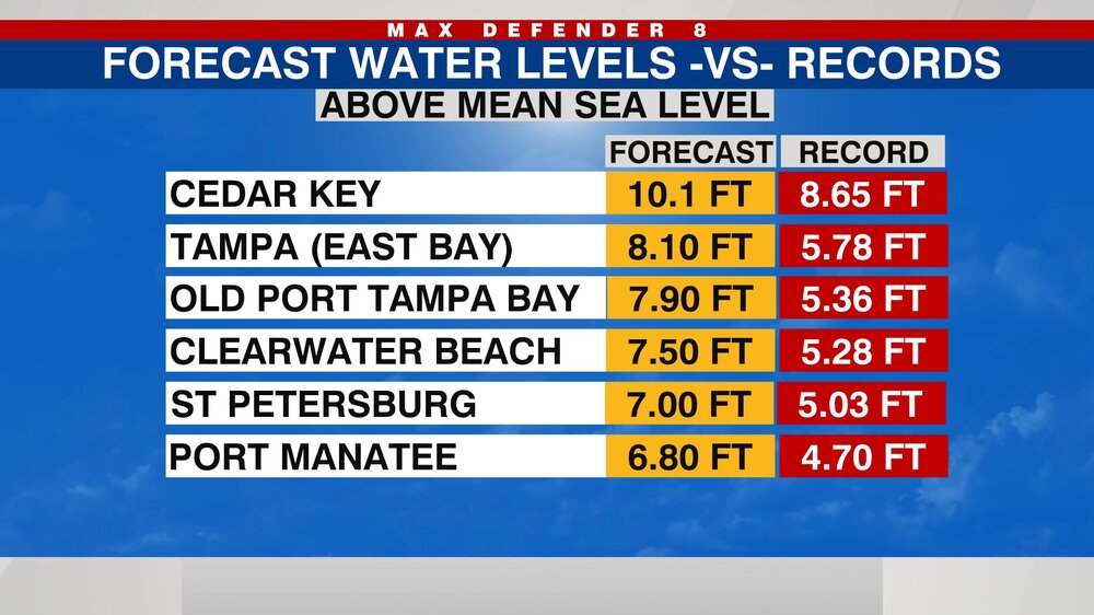
As a kid I thought Hurricane Agnes gave Tampa Bay a 10 ft storm surge. Photos I have seen are higher than any storms I can remember.
-
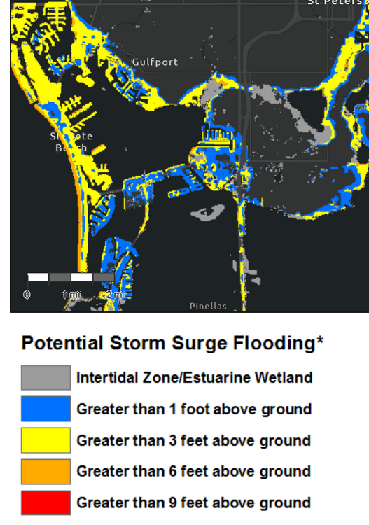
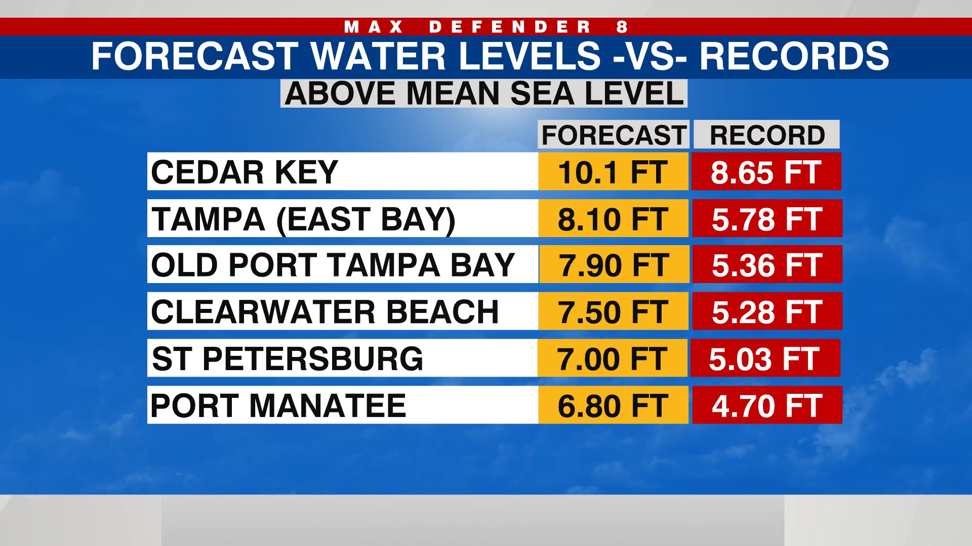
The Storm Surge prediction this time yesterday was almost all Greater than 9 feet above ground in our area so great news for Gulfport FL if this is more accurate. We are pretty used to 3 to 6 feet surges.
https://www.nhc.noaa.gov/refresh/graphics_at4+shtml/152934.shtml?inundation#contents
-
3
-


Tropical Storm Jerry
in Tropical Headquarters
Posted
Is the swamp hot enough to feed a low over some land?")
The breeze feels good, we've had rain up here so not complaining for this year. Last year was a nightmare right now.