

Prospero
-
Posts
1,095 -
Joined
-
Last visited
Content Type
Profiles
Blogs
Forums
American Weather
Media Demo
Store
Gallery
Posts posted by Prospero
-
-
11 minutes ago, FPizz said:
Weather channel at my hotel. Can't attach a pic unfortunately, file too big
You have a webcam?? How about a website link?
is this the one with the beach erosion. UGH
-
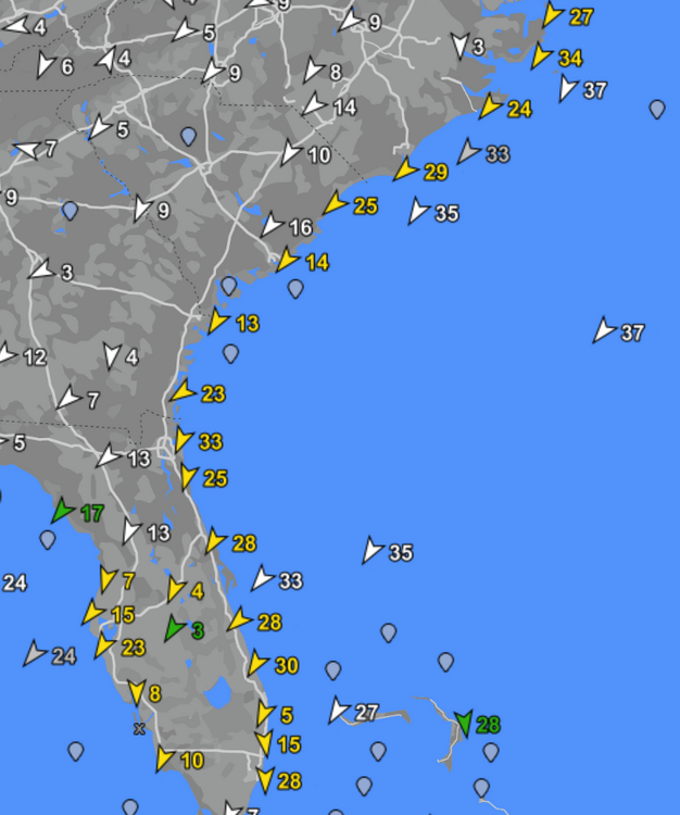
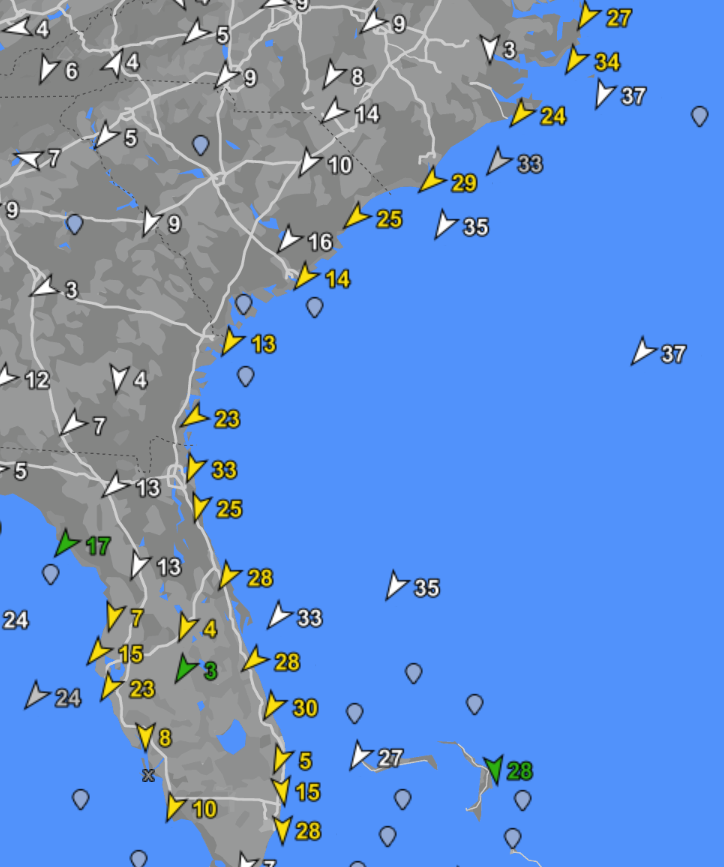
The strongest winds right now are on the NC coast. So far the highest gust I've seen is 58 at Alligator Bridge.
-
We've had gusts to 40 mph on Tampa Bay.
-
22 minutes ago, StantonParkHoya said:
Can we ban mentions of Charley?
Charlie the Cat 5?
-
1 hour ago, Tezeta said:
Charley was a 4
Whatever. The Legend is Charlie was a Cat 5 badass legendary storm that is known as the most mighty badass legendary Cat 5 to ever hit these parts in a long time.
Don't mess with me on banter. Charlie was a Cat 5 for the Legend.
Maybe the Cat 5 legend was born when the hype was all about rapid intensification over favorable conditions on its way to destroy Tampa Bay. Was there a Cat 5 model coming over the Sunshine Skyway Bridge over Tampa Bay?
-
17 minutes ago, StantonParkHoya said:
...gouge my eyes out
Please don't, but I understand.
Charlie, the famous Cat 5 (about the size of a Dime), was heading straight into Tampa Bay. The traffic jams right now may not beat Charlie's.
You know, every minute checking forums, TV, anything that had latest information. Right in the path of the Cat 5. Past couple or few days it's been building. The latest NHC graphic is very worst. Yet, as the tracks go this way and that, no matter what they can not be worse than this moment where I live.
")
-
Live storm streaming HD video from Gulfport Florida.
Its raining. But our cool little town if there is any kind of Storm Surge attracts all of the local TV news as our downtown is low and the photo ops are always news worthy. For years I dreamed of a live webcam in Gulfport for a storm. Well, with the local rag we just pulled it off:
https://thegabber.com/gulfport-fl-beach-webcam/
We have a solid UPC battery backup that will record for several hours (if the water does not drown all our equipment), but come back to see how the street looks while it is live.
Eta has 4ft at this location. Irma a bit more. Agnes has the record as far as I know.
We hope it stays online enough to see!!
-
 2
2
-
-
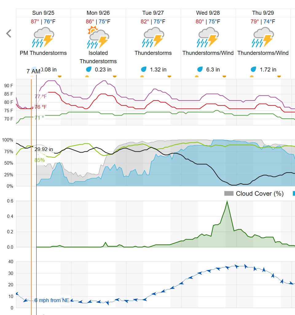
We're still a couple days out in Tampa Bay. Tracks do change, so hoping for good news. Still concerning to see the predictions right now.
The day Irma was coming into Florida, Tampa Bay was the target but it went in much farther South than expected. We still got hammered by strong TS conditions which created a big mess.
-
Not looking good for Tampa Bay. Our home is five blocks from Boca Ciega Bay at about 15ft elevation. We are not considered in a flood zone, but a 15 foot storm surge is not impossible.
-
 2
2
-
 2
2
-
-
3 minutes ago, dan11295 said:
Best scenario for Tampa at this point would be for Ian to come ashore further south. Of course the downside of that is likely going to be a stronger storm at landfall. South of Tampa probably has a much higher risk of coming ashore as a major.
If that happens we just worry about a wind/rain event as all the water in Tampa Bay will be sucked out and pushed into Sarasota Bay or wherever.
-
1 minute ago, StantonParkHoya said:
As has been mentioned, winds are really a non issue compared to the surge
Hurricane Agnes was biggest surge we've had in about 100 years. Wind was a non-issue, rain was nothing memorable. But the 10ft Storm Surge across Tampa Bay was indeed something to remember.
That is a 10ft surge. We hear about 30 ft sometimes when we are in the cone of a big one.
-
Evacuations won't happen here in Tampa Bay until Warnings are out. Supplies are already hard to find; water, batteries, etc. Supermarkets and stores like Walmart have been packed.
Some of are "getting ready" to put up window protections and batten things down. But we'll wait a while still. What I am doing in my backyard is something that I've wanted to do for a few years anyway, ever since we recreated our yard after Irma. LOL
-
11 minutes ago, MANDA said:
So at 5pm it is nudged a little to the right by 15-20 miles. Peak intensity the same as 11am advisory and maybe a bit stronger as it nears landfall. Track will make big difference on intensity at landfall. If it hugs right side of cone stronger - hugs left side weaker. Gut feeling is another nudge or two eastward over the next few cycles.
For Tampa Bay that is what do not want to see.
I'm working in my backyard, so many "things" out there in our oasis tropical paradise.
Several years ago we did some paver work along our driveway and had a lot of leftover pavers we could have sent back. But for me I like a kid with big box of Leggo and built structures in my backyard for plants and decorations. But some of them are in the way of securing our windows and patio, so I am moving them to a different area. Just in case we need to scramble.
My back is already starting to ache and I have a lot more to move...
-
12 minutes ago, MANDA said:
So at 5pm it is nudged a little to the right by 15-20 miles. Peak intensity the same as 11am advisory and maybe a bit stronger as it nears landfall. Track will make big difference on intensity at landfall. If it hugs right side of cone stronger - hugs left side weaker. Gut feeling is another nudge or two eastward over the next few cycles.
For Tampa Bay that is what we do not want to see.
I'm working in my backyard, so many "things" out there in our oasis tropical paradise.
Several years ago we did some paver work along our driveway and had a lot of leftover pavers we could have sent back. But for me I like a kid with big box of Leggo and built structures in my backyard for plants and decorations. But some of them are in the way of securing our windows and patio, so I am moving them to a different area. Just in case we need to scramble.
My back is already starting to ache and I have a lot more to move...
-
2 minutes ago, Hotair said:
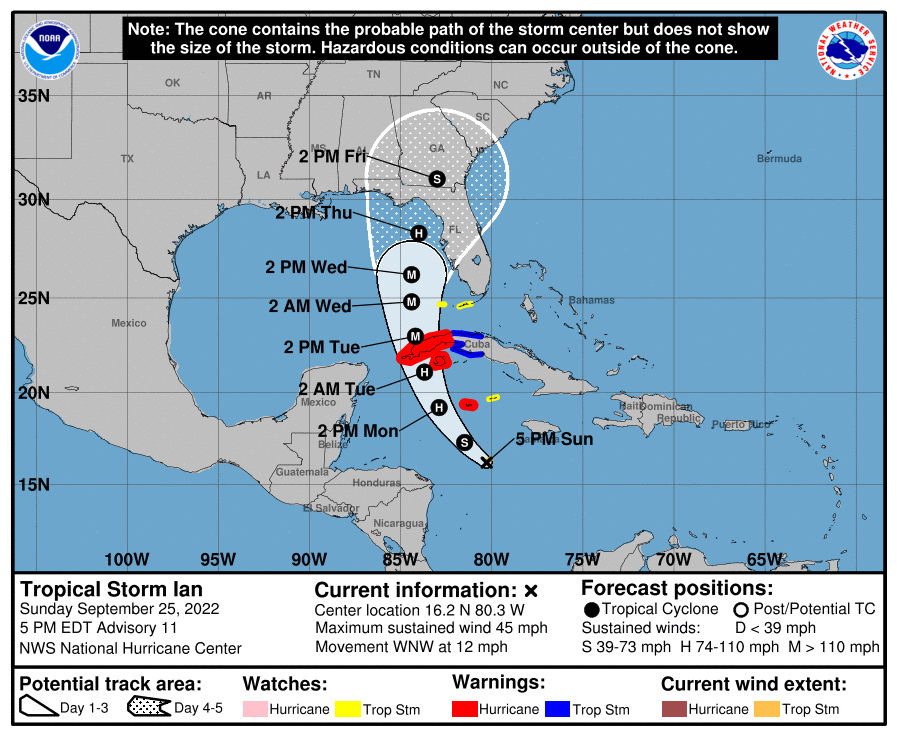
Significant shift east.
-
1 minute ago, Weather Mike said:
you are correct
thanks
So one is shifting east, the other shifting west??
"Ensembles, not operationals"
-
4 minutes ago, tiger_deF said:
Ian's structure is improving, but it looks absolutely terrible on IR (considering it was forecasted to be near hurricane strength by now)

It's funny how we see this happen so much over the last coupel years or so.
But if it was heading into the Yucatan, we'd see the most beautiful crystal clears eyes. Or maybe if was less than 70 miles from western Louisiana.
-
2 minutes ago, TPAwx said:
Still high uncertainty with the track and intensity at this stage, could easily miss to the south.
Were you reading my mind or was I reading yours when we posted at the same time! LOL
"Granted we were relieved when Irma went in south, but it was a hard few weeks after anyways even with the near miss. "
-
 1
1
-
-
22 minutes ago, cptcatz said:
Not necessarily. Surge would be worse in the first scenario. Look at the difference between Katrina and Ida.
Either way I suspect Tampa Bay will mostly be surprised and shaken if one of these being in the cone of a big Hurricane ever actually hits us. Granted we were relieved when Irma went in south, but it was a hard few weeks after anyways even with the near miss.
-
Better a Major coming at you and weakening into a TS than a TS suddenly becoming a Major at landfall.
")
-
2
-
1
-
-
12 minutes ago, turtlehurricane said:
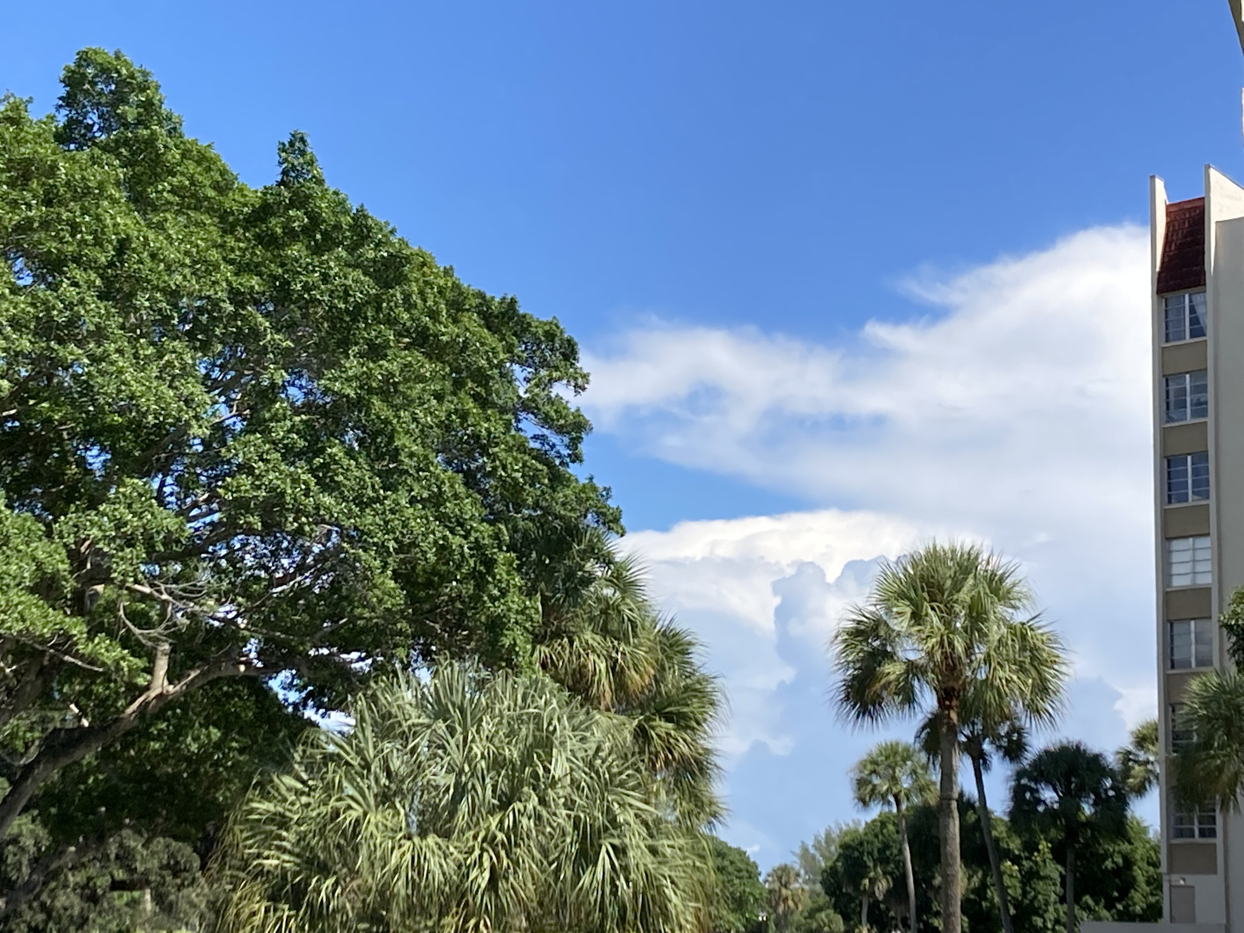
Beautiful sun and a wonderful breeze coming off the ocean.
I’m having deja vu. These conditions feel very similar to the day before Wilma. Just something about the air and the wind is exactly the same.
1st outer bands are looming on the horizon literally

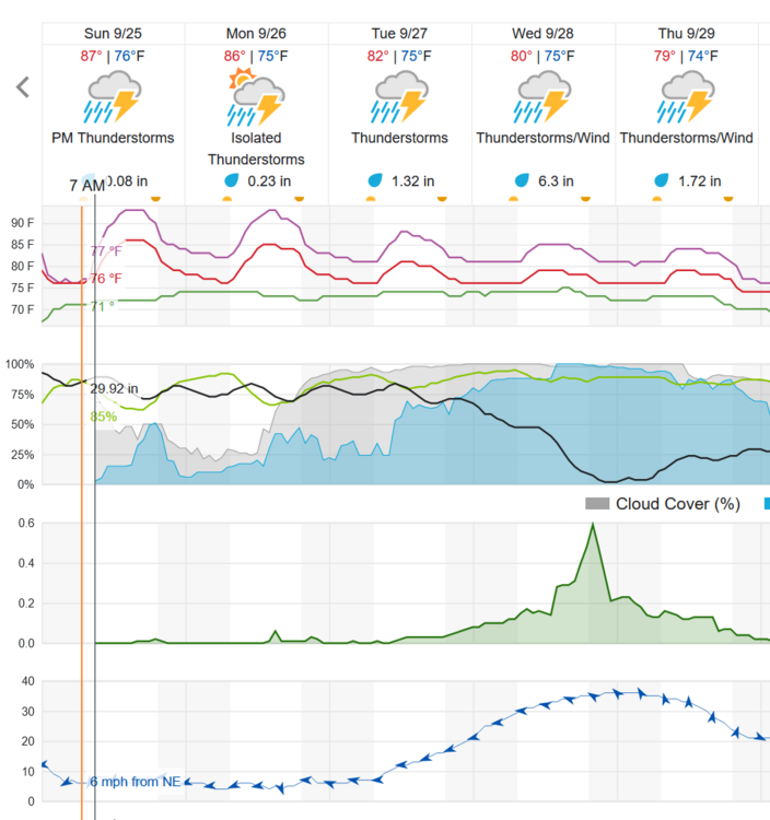
I'm starting to look at what I need to do outside. It is hot and muggy, but yea me too feels something. Hard to say impending doom, but definitely fuel for anything that happens. It's been quiet this year and we know there is energy we do not even understand that wants to pop.
Many times we prepare and it is for nothing. Ian looks like a mess, even around here it is what everyone is talking about and most are dismissing it. Charlie took a lot of us by surprise even though we watched the hype for days. But it had been quite a while since a real storm.
If Ian gets it together and becomes a Major off the coast from here likely closer than Hermine was that knocked out power and took down weak trees, some prep is worthwhile. If it inches closer and is a solid Hurricane, we'll experience worse than Irma that was over the middle of the state. We were out of power for over two weeks and had two big oaks down and thousands of dollars of tree service and debris removal in our yard alone. We didn't even have sustained 70 mph winds, but did have a few gusts in the 80's or so.
Yet Storm Surge could be the biggest impact here if it moves slow.
-
1
-
-
Here in Pinellas County FL (Tampa Bay) it looks like today and early tomorrow is the time for outside preparations to avoid doing it in the rain. I'll start in our yard today as we have a lot of bird feeders, decorations, and other potential projectiles to secure. Plants in pots will be put where they should be protected from higher winds.
-
1
-
-
5 hours ago, lilj4425 said:
I like beer.
The blue turd is here.
Stocked up on beer today. We still have water left over from Irma. Funny in all the power outages with so many storms, water was never as issue. Beer was. And ice was nowhere to be found.
Neighbors with generators were fine until the gas ran out. Then they were looking for ice too.
We are good on toilet as long as it stays dry...
-
Someone needs to go up there this year and install some web cams. I'm not seeing anything live.
-
1
-

Hurricane Nicole
in Tropical Headquarters
Posted
Curious about the second eyewall.