

Prospero
-
Posts
1,162 -
Joined
-
Last visited
Content Type
Profiles
Blogs
Forums
American Weather
Media Demo
Store
Gallery
Posts posted by Prospero
-
-
5 hours ago, dbullsfan said:
Looks like the chances of a Tampa area landfall are fading quickly.
We had two squalls come through today here in Gulfport (Tampa Bay area) with decent winds (gusts in the 30s) and sideways rain. Winds were stronger yesterday (gusts in the 40s) though.
I am still very interested in Eta, just one of the busiest work schedules I have had in months. Hard to enjoy a storm when you cannot watch it obsessively. UGH
-
2 hours ago, Modfan2 said:
Eta appears to be tracking more nw than west; decent banding about to hit Ft Lauderdale
Does look farther north than expected to me.
Edit: I can't seem to find a radar right now.
-
Just now, FLweather said:
Could get a little dicey around here Thursday into Friday. That's from Tampa following the I4 corridor into Orlando. According to the Hwrf.
That's what we are keeping in the back of our minds in my home. Hoping Eta does not fire up in the Gulf like it did before hitting the Mosquito Coast. I doubt that will happen, but a TS could be visiting.
-
 1
1
-
-
Tampa Bay/Gulfport:
Gust to 39 mph at the Sunshine Skyway Bridge fishing pier, 41 mph at Surfside Condos on Clearwater Beach. We've had several gusts around 33 mph here in Gulfport. It's been windy for well over 24 hours.
No measurable rain to speak of, but we are quite a bit north right now. We do expect some later tonight as there is a band on the radar that could make it here.
So far it's not the strongest storm of the year for us, but watching closely in case it does strengthen and turn back to the Gulf Coast in a few days.
It does have that "feel" that we all know so well in tropical system areas.
-
1
-
-
6 minutes ago, Leo said:
So it appears I picked literally the WORST week to head to Orlando ^^' I've never been in a tropical system before so a part of me is a little excited but I hope this things speeds up a bit because I maybe in the system my entire stay. What's do you all think the chances of it reintensifying into a hurricane? And any lesser known tips I should be aware of in case that happens?
Maybe not the worst week. For November, you will enjoy a very warm week with tropical winds from the south. You may see some rain, but for the most part you will see a lot of sunshine. Orlando should be too far east to get the big rain, but the tropical breeze may be here all week.
You'll see clouds moving quickly over and get to experience a "tropical" system. Even if Eta becomes a hurricane, it will not be a Charlie that races across the state impacting Orlando.
Enjoy your visit! You may have picked the BEST week to visit central Florida.
")
Tampa Bay, maybe not as much. LOL
-
8 minutes ago, dbullsfan said:
Quite interested in later in the week. When is the last time a TC hit the Tampa Bay Area directly from the Gulf like some models are suggesting?
It's been a while. Nestor was the biggest impact we've had since Hurricane Irma.
-
On 11/6/2020 at 1:35 PM, the ghost of leroy said:
Zzzzzz
Did the ghost put almost everybody to sleep yesterday about Eta?
")
-
4 minutes ago, thunderbolt said:
The million dollar question is did you Save the beer
I have the bruises to prove it! LOL
Top of early morning hurricane shopping list:
- beer
- more beer
- coffee
- beer
- D batteries
- beer
-
1
-
6 minutes ago, turtlehurricane said:
Having another powerful rainband now. Highest winds yet here, 40-50 mph. Avocados began raining down right in front of me, I dashed out to get them and got 4 big avocados in just a minute!
EDIT: FLL gusting to 48 mph again, just like the last band
Guacamole central! All we have is acorns falling!
Sats look solid.
-
1 minute ago, FloridaTracker said:
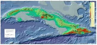
ETA is heading to an area of lower terrain in Cuba, trying to thread the needle.
Of course, this is Eta. The storm that has surprised us all so late in the season.
Will it miss us in Tampa Bay, then hit Cat 3 and hit LA again? That would be par for the season. -
Strange, when Eta was aiming at the Mosquito Coast, there was some high-end met discussions going on here. Now that Eta is aiming at Florida, it's pretty slow. Granted I know, big news day, but Eta is big for us in the United States dangling peninsula.
-
1
-
-
1 minute ago, turtlehurricane said:
This rainband we just had easily had tropical storm conditions, torrential rain and lots of wind.
In-fact, it is confirmed. KFLL gusted to 48 mph and a site on the coast gusted to 49 mph.
Crazy were already getting tropical storm conditions, and it's gonna be deteriorating all the way through Monday morning.
I was just outside enjoying a beer and a gust came up that almost knocked over one of our porch umbrellas that has over 100 lb of blocks on its base. That has not happened since we put it up in July with all of our strong afternoon thunderstorms that we get. And we are all the way up in the Tampa Bay area.
The umbrella is now down, tied up, and put away for the next week or so. Doing more tonight that I planned on for the morning already. We have a yard of projectiles and objects that are not TS wind friendly. (My wife who was in Andrew nags at me about what "could" happen if we get a strong storm. They were not able to get out of their destroyed second floor condo due to landscaping gravel that had been picked up and piled up in front their door overnight.)
-
2 minutes ago, turtlehurricane said:
Just went outside and it is ominous. Lots of wind, and Mesowest showing wind gusts exceeding 30 mph here on the coastline.
Radar shows a strong rainband is moving in. It's already flooded out there, the street I live on is literally a river at this point, since the grounds were saturated from lots of rain this past month, and we had alot of rain earlier today.
The flooding threat here in Southeast Florida is extreme. NHC forecasting 10-15 inches, which would be totally insane on top of the already saturated grounds.
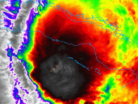
Meanwhile Eta looking impressive as it approaches landfall in Cuba. There is a tremendous amount of upper level divergence that is fueling Eta. It's concerning what could happen once this gets over the Gulf Stream considering the upper level support. May not be a classic looking hurricane, but could end up with a 100 mph sub-tropical 'perfect storm'.
We are planning a shopping list for Thanksgiving and adding in late season hurricane supplies, like D batteries and filling up the gas tanks.
Wind chimes, bird feeders, potted plants, yard decorations are being secured early tomorrow. Hope I am not out in the rain doing it! -
DISCUSSION AND OUTLOOK
----------------------
At 700 PM EST (0000 UTC), the center of Tropical Storm Eta was
located near latitude 20.4 North, longitude 80.2 West. Eta has
recently jogged toward the east, but is expected to resume a motion
toward the northeast near 14 mph (22 km/h) tonight.  A turn toward
the north and northwest at a slower forward speed is expected on
Sunday and Sunday night, followed by a westward motion on Monday. On
the forecast track, the center of Eta will cross central Cuba
tonight, approach south Florida and the Florida Keys on Sunday, pass
near or over south Florida and the Florida Keys Sunday night and
Monday and be over the southeastern Gulf of Mexico on Tuesday.

Data from a NOAA Hurricane Hunter aircraft indicate that the
maximum sustained winds have increased to near 65 mph (100 km/h)
with higher gusts. Some strengthening is possible through Sunday
night, and Eta could be near hurricane strength as it approaches
Florida.

Tropical-storm-force winds extend outward up to 105 miles (165 km)
from the center.

The estimated minimum central pressure is 991 mb (29.26 inches)
based on NOAA dropsonde data.
OK, here we go.
-
1 minute ago, turtlehurricane said:
It was Shabbos, so I was not able to see any of the updates until now.
The day started with underwhelming weather. NWS said flooding should've began last night, but instead when I awoke it was just cloudy with intermittent wind gusts. Then in the late morning we had 1 passing heavy downpour, and then another heavy downpour around 1 PM.
I was beginning to question if anything was really gonna happen, since so many times this season storms have missed here.
However, around 4 PM it began to pour, and the rain didn't stop for hours. The winds were some of the strongest we've seen this year as well, easily gusting over 40 MPH.
Once I turned the computer on I see we are under a Tropical Storm Warning, with tropical storm conditions possible even tonight in rainbands, and indeed earlier we already has some Tropical Storm-esque conditions.
It seems this is a huge storm, and it's already begun, so tons of flooding and wind is coming. Most interesting wild card is it will be over the Florida Straits for about 24 hours, and it's already approaching hurricane strength, so we could easily see some RI especially since a ridge will be building in, which is a highly favorable setup.
NHC has appropriately issued a Hurricane Watch, since this could surprise everyone and go up to Cat 2-3.
I'm already looking at the SailFlow maps. Been breezy here all day in Gulfport, Florida. If this develops at all in the Gulf we might be hanging onto our hats, and scrambling to secure our homes.
One thing with this pass of Eta, we have good radar, hundreds of personal weather stations, and a ton of live web cams.

-
Entire season that started early, obsessed with every storm (as usual), and having taken some steps to prepare for storms I cannot now remember in 2020, we are looking at rain and winds to maybe start tomorrow. Prepared? Hardly. I am deep in a huge tight deadline project where I am learning a new programming language as I go. Perfect. UGH
In the past 18 years in Florida I remember hurricane's Charlie, Frances, Jeane, Hermine, and of course the doozy Irma.
Tropical storms too many to count, but Debbie brought the highest storm surge and over 16 inches of rain that was a disaster in itself.
Eta spinning off our coast for a couple days can outdo Debbie, and if it does become a hurricane most of us around here are totally not prepared.
Wish I was not so busy making a living this week!
-
1 hour ago, cptcatz said:
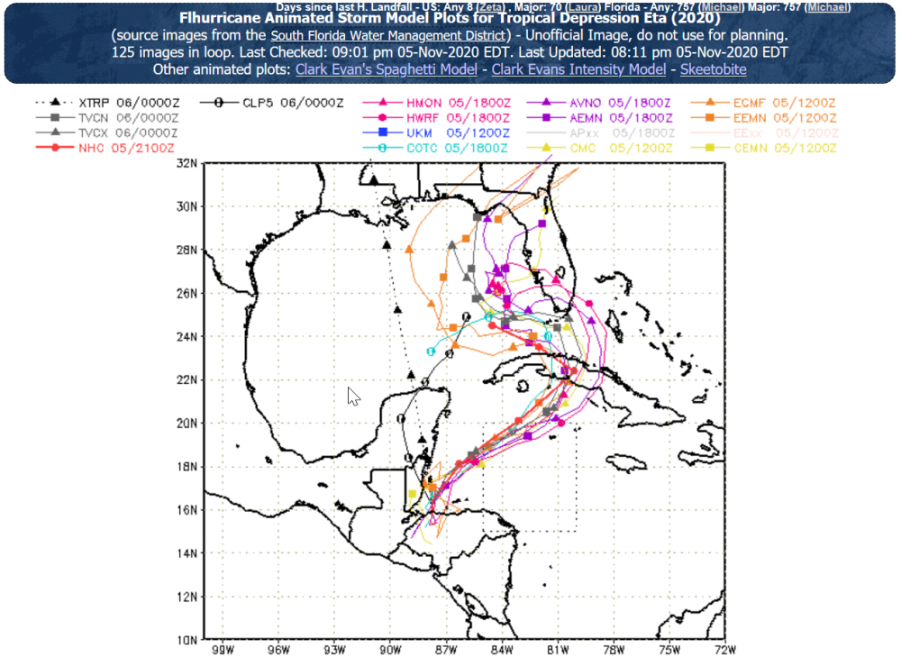
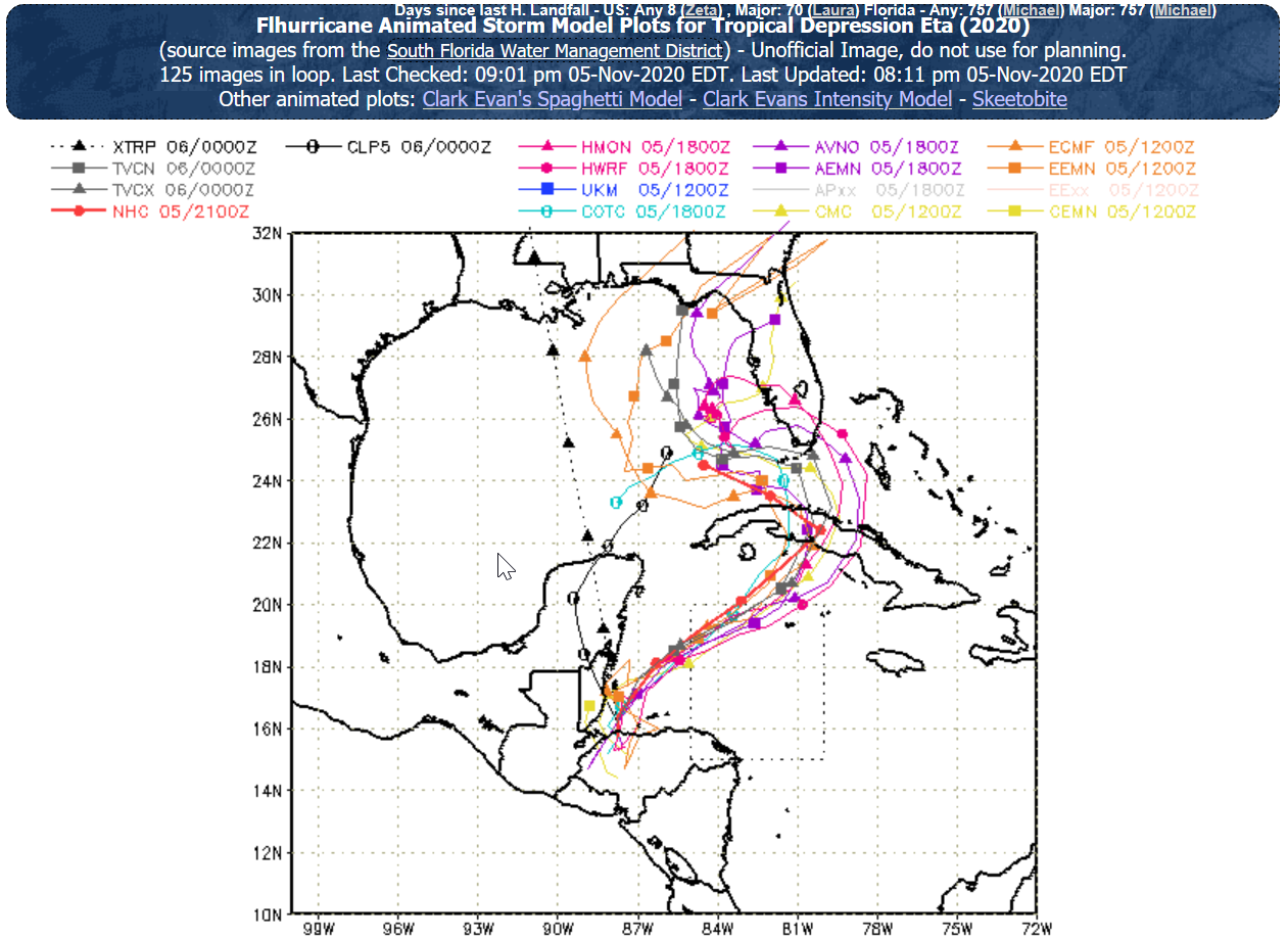
So the 18z GFS is coming in... brings Eta into the Gulf, intensifies, stalls, then moves south, eventually making landfall in where else but...... the Yucatan.
Storm roulette!
"Spin the wheel, where she stops, nobody knows!"
-
 1
1
-
-
Models are beginning to tighten up. Exciting, yet not great news for Florida. Models have been better this year than any year I remember.
My position for our home and Tampa Bay area is always, "Be as strong as possible without power going out, loss of life, and unreasonable cleanup expense."
-
The most fun model to watch for 2020 is the GFS Para. I hope it ends up someday as the "go to" model.

-
1
-
-
Anxious for the sats to start to show something pop up.
-
Quote
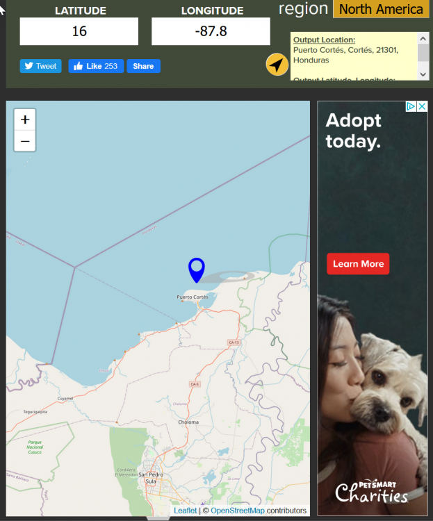
DISCUSSION AND OUTLOOK
----------------------
At 600 PM CST (0000 UTC), the center of Tropical Depression Eta was
located near latitude 16.0 North, longitude 87.8 West. The
depression is moving toward the north-northwest near 8 mph (13
km/h), and a turn toward the north is forecast during the next
several hours.  A turn toward the northeast is expected on Friday,
with this motion continuing through Saturday night.  On the forecast
track, the center of Eta will be over the western Caribbean Sea
through Friday, approach the Cayman Islands Saturday and Saturday
night, and be near Cuba on Sunday.
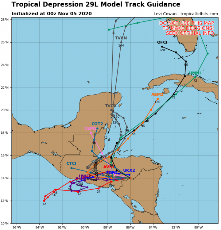
Is it over water yet? Looks like it:
-
4 minutes ago, turtlehurricane said:
18z GFS takes Eta right through Southeast Florida. First model run in awhile which has shown a direct hit here.
Hour 78... looks like a hurricane too. That would be crazy and awesome.
Wouldn't be surprised if we are watching models in December this year.
If we get a Tropical Storm out of this in Tampa Bay, we might feel like we finally have some immunity for the rest of the season...
But Louisiana doesn't seem to get immune no matter what.
-
25 minutes ago, stormwatcherJ said:
Wow, this thread has gone silent... everyone watching the election maybe??
I keep coming back, but until it gets back over water I guess nobody is excited. But here in Florida, we are paying attention.
-
1
-
-
14 minutes ago, cptcatz said:
What just happened to the models?
Bye Bye Eta?


Tropical Storm Eta
in Tropical Headquarters
Posted
Well, being 2020, we may be here tomorrow night commenting on how amazing it became in 24 hours...
Landfall as a Cat (?) in west LA?