

Prospero
-
Posts
1,162 -
Joined
-
Last visited
Content Type
Profiles
Blogs
Forums
American Weather
Media Demo
Store
Gallery
Posts posted by Prospero
-
-
1 hour ago, Orangeburgwx said:
What did it do
Sent from my LGL322DL using Tapatalk

-
17 minutes ago, dbullsfan said:
Seems like a lot of different routes all leading to impacts on the west coast of Florida, don’t get much action on this coast.
This year we have not even been in a single warning. That kind of makes it scary for us! 2020 is not over yet!
-
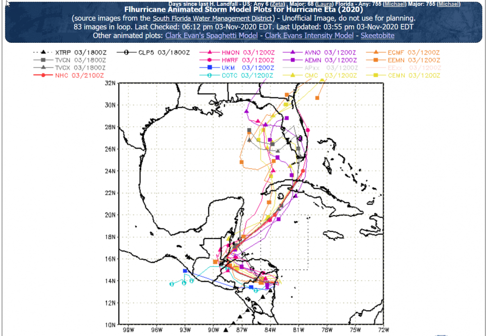
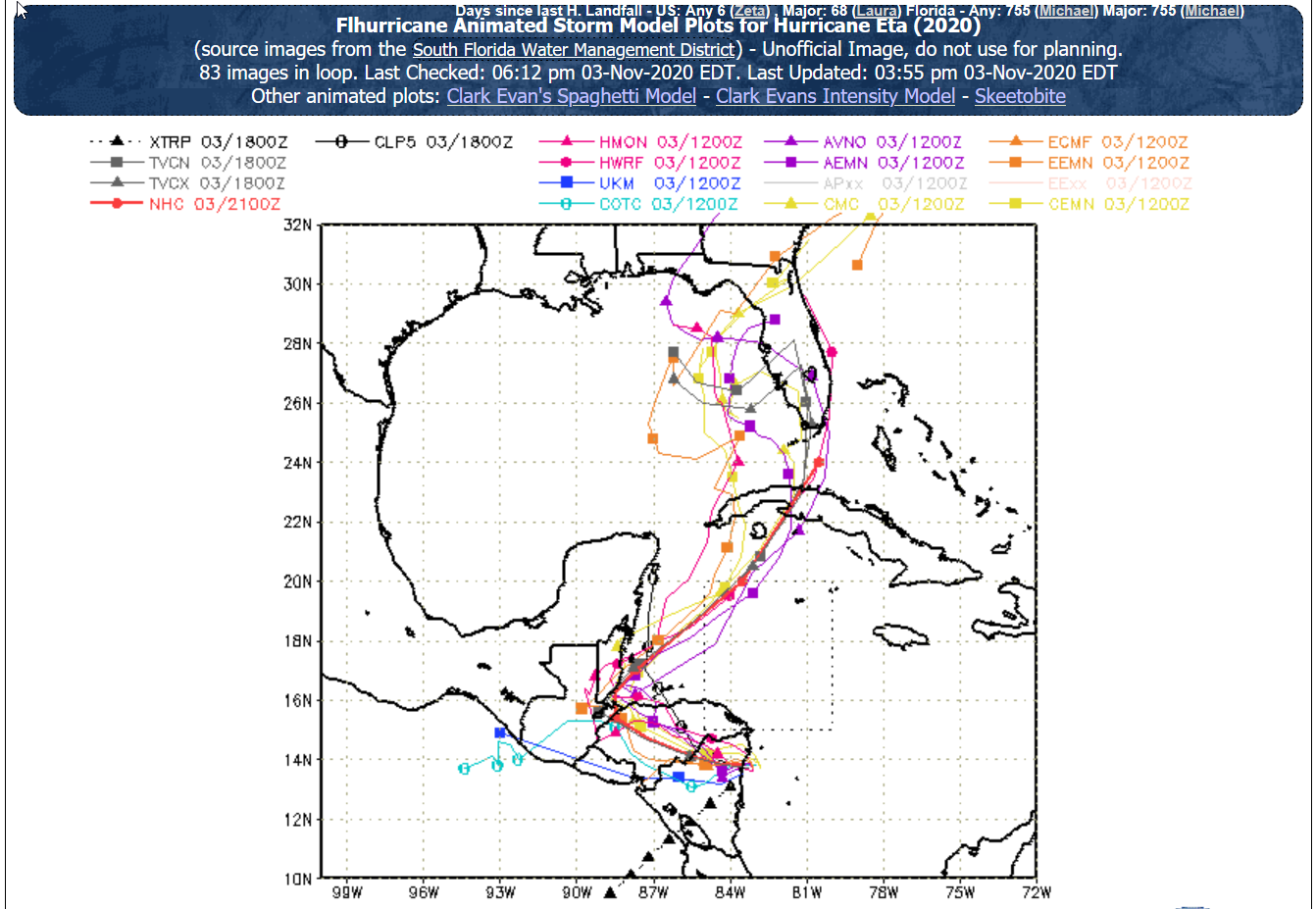
Big change from not so many hours ago:
-
11 minutes ago, Crocodile23 said:
I've seen these pictures some days ago on Philippines with typhoon Goni.
Doubt we will see anything from here for a while. We have sats to watch.
In time some pictures will show up.
-
45 minutes ago, dan11295 said:
Pretty sure the answer is no, for many reasons. Horrible area to chase, don't even know if foreigners can enter right now etc.
Plus without reliable cellular or internet access, why be there. Videos uploaded days later would not have the views.
From what I can tell there are no weather stations to see. -
927 beats Felix.
-
3 minutes ago, dan11295 said:
Remember at the 1 am advisory NHC had Eta as a tropical storm
They've been impressive with the tracks this year. See last Thursday evening:
-
 2
2
-
-
Just now, A-L-E-K said:
Just cycling thru COD satellite page taking it in
It's a beauty
-
Funny, when I watch the sat for 200 frames, when it stops I see the swirl go backwards. I don't think that has ever happened, and believe me I have stared at many 200 frame animations in my life.
-
I'm doing now here what I swore I would not be doing tomorrow night.
")
-
1
-
-
1 minute ago, Moderately Unstable said:
(1) Entries are allowed until the aircraft is "in storm": within the storm's circulation. Assuming this radius to be 150mi, at a speed of 240knots, they have around a half hour.
(2) Should I allow guess updates (yes or no)?
Why not. It's not over until the fat airplane sings.
-
Felix was 929mb and 150-knots.
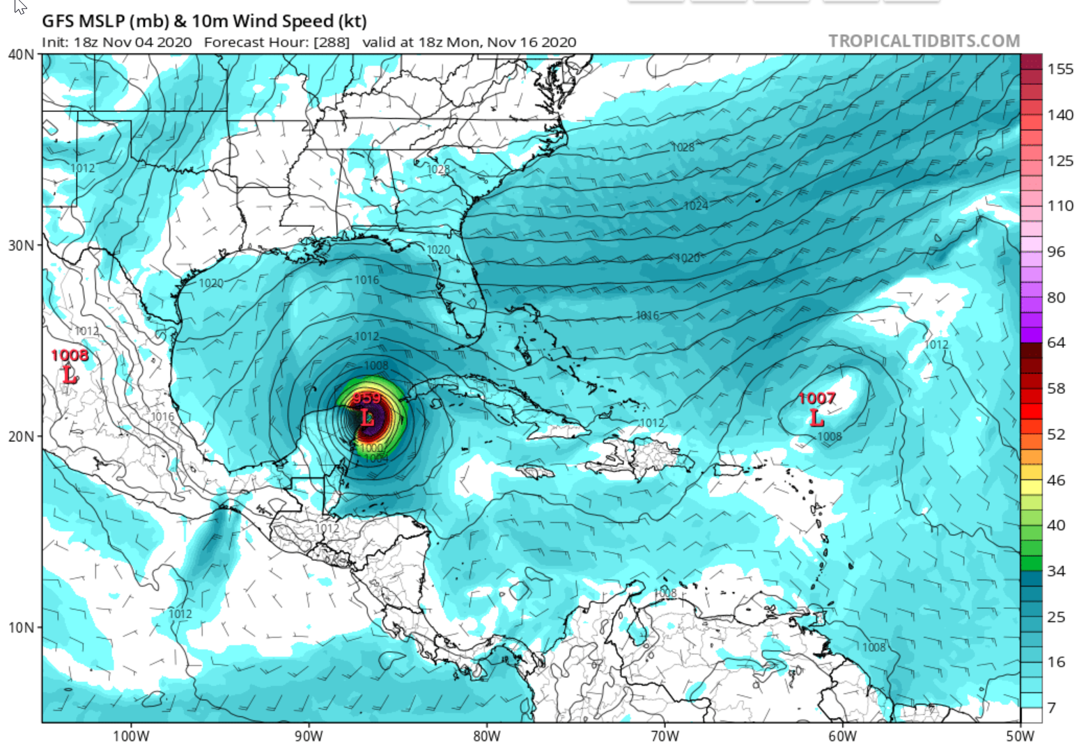
I'll gamble on November 2020 outperforming September 2007 in the same area.
911/160
-
2 minutes ago, the ghost of leroy said:
you know shits getting weird when you have a 35 keys level storm in November
Oh shit is getting weird all right, not just here.
-
200 frames
-
3
-
-
Wobbling east.
Yea I know, just a wobble.
I remember some years ago I heard when a storm gets strong enough it starts to decide its own path. Was that an urban legend?
-
1 minute ago, Will - Rutgers said:
wow. what're the odds the season's last storm is its most powerful?
unless, of course, the atmosphere intends to keep spawning storms through late fall...
My guess is the odds are that this is not the last storm of the season.
-
1
-
-
Another jog to the south...
-
7 minutes ago, sojitodd said:
It looks like the eye is directly east of that island per the post directly preceding yours...and that would put it only about 20 miles north of Puerto Cabezas. It had better not drift further to the southwest or it could go right over them. It will probably be bad enough as it is.
It appears they did evacuate as much as possible based on a Sunday news report:
QuoteAs a first step, the naval force and fishing companies are helping to evacuate the indigenous Miskito families living in the Miskito Cays, off the coast of the northern Caribbean, Sinapred director Guillermo González told the official Channel 4.
https://ticotimes.net/2020/11/01/nicaragua-declares-preventive-alert-as-tropical-storm-eta-threatens
-
1
-
-
The larger of the three islands that Eta is soon to pound is Miskito Cay. It has people living on it.
The official website says this, "The Miskito Cays were strongly affected by the devestating Hurricane Felix. Currently, tourism in this area is hardly possible, as the local community is still recovering."
https://vianica.com/go/specials/24-miskito-cays-nicaragua.html
Scary
-
1
-
-
Have we ever lost a Hurricane Hunter plane in a storm?
-
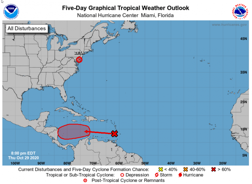
Any bets we are here in December discussing an active 2020 hurricane?
-
19 minutes ago, Windspeed said:
At any rate, interesting motion.
If this stays out over the water...oh my!
-
1 minute ago, dan11295 said:
I direct hit on the only population center in the area would be unfortunately, luckily not a whole lot of other population centers in that area. Hopefully most of the fain falls in the swamps.
Hopefully Puerto Cabezas rebuilt stronger after Felix and might be lucky enough to be on the south side of the storm so the wind and surge will not have much impact.
No chasers will be there I am sure. And news will take a while to get to us. So landfall will be all about sats and estimates. Maybe some weather updates, but we may not even see those.
Of course the floods in the mountains and subsequent mud slides are a nightmare always.
-
2 minutes ago, the ghost of leroy said:
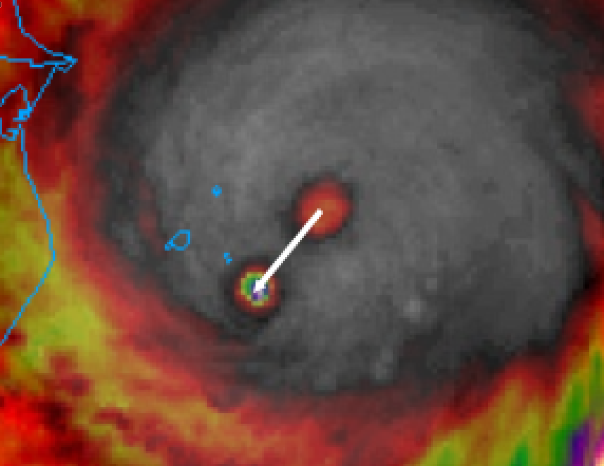
You can stare at this all day but I see the collapse of a nano sized eyewall and the emergence of merely a micro sized eyewall. But maybe that’s just me seeing what I want to see...
Crazy thing is, I could stare at that all day.
Edit; This better though...
https://weather.cod.edu/satrad/?parms=meso-meso2-sandwich-200-0-50-1&checked=map&colorbar=undefined

Tropical Storm Eta
in Tropical Headquarters
Posted
I will be disappointed if we do not host a tropical storm in 2020 here in Tampa Bay. I know that is sick, but this is 2020!!