ORH_wxman
-
Posts
93,092 -
Joined
-
Last visited
Content Type
Profiles
Blogs
Forums
American Weather
Media Demo
Store
Gallery
Everything posted by ORH_wxman
-
Spring 2020 New England Banter & Random Obs
ORH_wxman replied to CapturedNature's topic in New England
Alright ya’ll...drop the blame game on the thread being closed. There’s plenty of reasons including posters in this subforum. It ran its course. Yall can take it to PM or Ampol. -
Spring 2020 New England Banter & Random Obs
ORH_wxman replied to CapturedNature's topic in New England
Yeah ya’ll, take the personal stuff with your rifts at Ampol out of here. -
Spring 2020 New England Banter & Random Obs
ORH_wxman replied to CapturedNature's topic in New England
It had run its course. We’re the most lenient subforum when it comes to moderation, but the thread had become more and more political. Early on, the thread typically got back on track quickly when it strayed, but the political posts and personal attacks started dominating ....and rather than start expending more time and energy moderating people for content in a thread that was marginal even in it’s early days, it was decided to shut it down. -
Weak sea breeze advancing to the west...only should drop temps into the 70s though. 81 here currently.
-
Looks similar aloft to ‘07-‘08 actually. Wouldn’t be surprising at all.
-
You’re probably wondering what the hell all the rumors were about moderate summers in New England, lol....prob near-record warm start to summer up in northern New England. You’ll get an AC and then not have to use it for the next 2 summers...LOL. Nice reprieve today though.
-
Also gotta watch out for a raging bull moose during the rutting season in fall. All jacked up on testosterone. They have been known to go psycho and attack people trying to shoo them off. I remember one story where a guy got attacked after the moose was curious about its reflection in a large window while passing by on the property. Its funny because other times of the year they are pretty skittish.
-
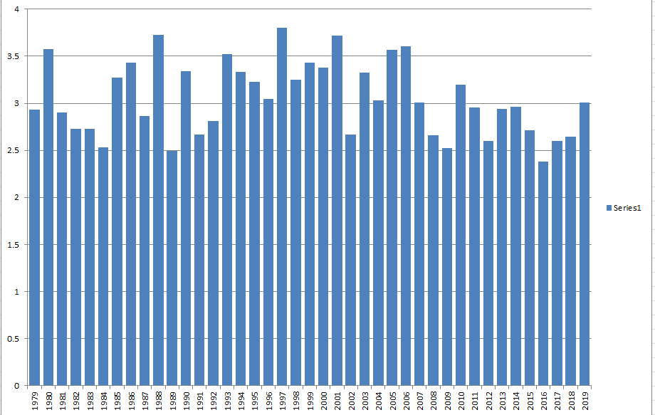
We have the final June numbers in....here's the breakdown of what the minimum in 2020 would be if we followed the same path as every other year: So if we followed the same path that 2019 followed after 6/30, we would finish at 3 million sq km of sea ice area. The post-2007 average path followed is 2.78 million sq km which is what I will use as my baseline. However, there are two factors that will cause me to lower this baseline a bit. First, is that we had a 340k(!!) loss on 7/1....and second, we have a very hostile pattern for the ice. We're currently into a nuclear dipole pattern which would continue to assault the ice for the next week. This will help increase melting and melt ponds while the sun angle is still pretty high in the arctic. Normally, I would put the chances of passing 2012's minimum of 2.228 million sq km at close to 0% based simply on the chart above. But I'll give it an outside shot of happening this year given the current pattern and the huge loss on 7/1. My prediction will be for minimum sea ice area in 2020 is 2.5 million sq km +/- 300k. A minimum of 2.5 million sq km would be 3rd lowest. The top two are 2012 (2.228) and 2016 (2.463). Sea ice extent is a little more fickle since it can depend on compaction vs area which is very straight forward. But for the minimum daily NSIDC sea ice extent, I'll go with 3.8 million sq km +/- 500k. I use larger error bars on the extent due to the much higher standard deviation.
-
We've slowed down recently from the reverse dipole.....2020 now trails 2019, 2012, 2010, and 2007. Though not by huge amounts, so a top 3 melt season is still very much possible. We'll see if the area losses pick back up as the reverse dipole weakens.
-
Massive losses in area from the dipole pattern that just happened.....we now only trail 2012 for lowest area on this date. 2007 and 2010 (and to a lesser extent 2016 and 2019) lose huge area though over the next week, so the question is whether we can stay in the top 3 or top 5 as the weather goes to a reverse dipole over the arctic basin.
-
Yeah I'm a huge fan of December snow....which is why I couldn't rank last season an F. We had pack here for like 27 out of 31 days and 27" total. That is an excellent month. Would have been better without that hideous cutter around 12/8-12/9 but at least we refreshed right after that with a 5-6 incher. I'm still waiting for a Dec 1995 though....basically where we run the table in December. Those are hard to get. All of our recent good Decembers that had big events before Xmas had black marks on them....2007, 2008, 2013, 2017, 2019...2009 was ok, but even that had the ugly cutter right after Xmas. Latitude is really important in December though....moreso than other winter months including March.
-
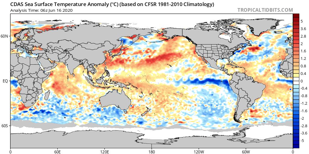
I'm also wondering if we're finally going to change the PAC up a bit....all that heat in the eastern PAC to the north of ENSO region (like off coast of Baja and CA) is eroding more than most recent years. Still not there yet, but something to track

-
Time to bump the sea ice tracking for 2020....we're coming off last year's top 3 finish for both area (3rd lowest) and extent (2nd lowest). 2020 is off to a slower start than 2019 was, so it will need to catch up some more to get into contention. 2020 started off fast in May with extensive meltponding (most on record), but that trend reversed near the end of the month and early June when extensive refreezing of melt ponds caused the area to stall. We've been falling faster again recently. For those who follow this thread regularly, you know I like to track NSIDC area in late June because it is the most accurate predictor of minimum area/extent later in the season. Here is where we currently stand on area vs other years (i.e. 2019 had 250k less area than this year on this date) 2019: -250k 2018: +300k 2017: +230k 2016: -150k 2015: +90k 2014: +340k 2013: +390k 2012: -600k 2011: +120k 2010: +150k 2009: +860k 2008: +410k 2007: +10k As you can see, we're running somewhat low in the post-2007 world, but not as low as several years. You'll also note that some years like 2011 which finished very low were not standing out yet. There is still time for things to change in either direction which is why I usually start tracking closely in mid-June through the end of the month when I make a prediction based on the month-end values. There is currently a hostile pattern over the arctic for the ice which is aiding some big numbers right now, but the forecast looks to go toward a reverse dipole pattern by the end of the week and stay there all of the next week if ensemble guidance is correct....so that would likely slow down the losses. I'll update this tracker every few days until month-end....probably doing daily updates in a final few days of the month.
-
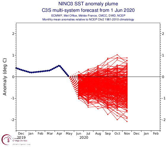
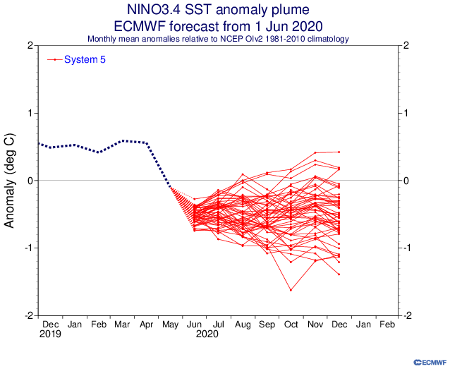
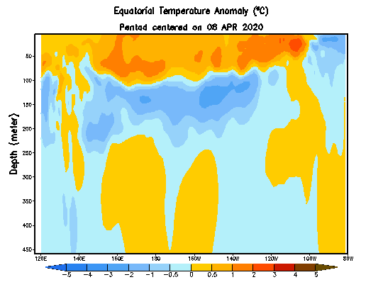
Didn't see a thread yet for next winter. We're getting past the "spring barrier" for ENSO forecasts....which means we're emerging into a clearer picture of what it will look like in that region going into fall. There isstill uncertainty, but it is reduced compared to a few weeks ago. We're currently looking like we will be heading into La Nina after a weak El Nino. Here's the latest ECWMF and C3S (used to be EuroSIP) plots: They are pointing toward weak El Nino by fall....we'll see if that develops further into a moderate/stronger forecast as summer wears on. There are some very cold anomalies in the eastern region at depth, so it's possible that it could translate into something more than a weak Nina if we start getting easterly feedback. Anyway, there is precedent for La Nina winters following a weak El Nino....most recent examples are: 2007-2008 2005-2006 1995-1996 1970-1971 3 of those 4 years were pretty strong winters in New England. The outlier was 2005-2006, though all 4 had big Decembers. The QBO looks to be going negative (though it's not in a hurry at the moment)....that would make '07-'08, '05-'06 and '70-'71 the best matches. '70-'71 and '07-'08 were pretty potent La Ninas (both high-end moderate or borderline strong) while '05-'06 was not. It remains to be seen where this one is headed. There is evidence in both directions. I'm kind of leaning moderate at the moment with the big subsurface anomalies and the model guidance already going solidly weak Nina....I feel like the guidance tends to underestimate the strength historically.
-
I’ve played both Putnam and Thompson but it’s been a while. Good courses. One of them was pretty long...I think Putnam? I only got out once last year but somehow shot 83.
-
May 8-9 mid-spring rain, snow, cold, wind obs
ORH_wxman replied to CT Valley Snowman's topic in New England
It’s an annual occurrence according to Cranky. -
May 8-9 mid-spring rain, snow, cold, wind obs
ORH_wxman replied to CT Valley Snowman's topic in New England
He said we only got highs in the 40s last May so it’s NBD. Im guessing he completely ignored the low temps. -
May 8-9 mid-spring rain, snow, cold, wind obs
ORH_wxman replied to CT Valley Snowman's topic in New England
This feels like late November or early December with this airmass and popcorn squalls under a ULL. Yet we’re 6 weeks from the solstice. -
May 8-9 mid-spring rain, snow, cold, wind obs
ORH_wxman replied to CT Valley Snowman's topic in New England
Chris I think that was this one...incoming for ORH now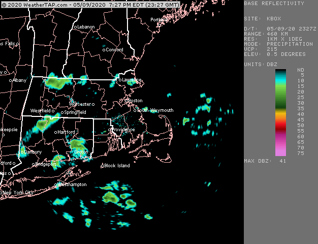
-
May 8-9 mid-spring rain, snow, cold, wind obs
ORH_wxman replied to CT Valley Snowman's topic in New England
It’s really just the annual May cold snap. -
May 8-9 mid-spring rain, snow, cold, wind obs
ORH_wxman replied to CT Valley Snowman's topic in New England
Wow that’s awesome. It’s not even up by CAR and it’s mostly under 500 feet. For those wondering where Lee Maine is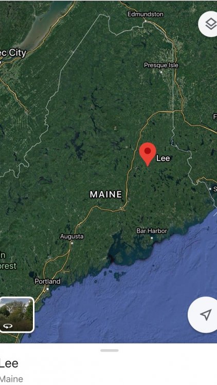
-
May 8-9 mid-spring rain, snow, cold, wind obs
ORH_wxman replied to CT Valley Snowman's topic in New England
Nah, you had a high of 45 last year on east winds with sheet drizzle. It’s the same thing. Annual occurrence. -
May 8-9 mid-spring rain, snow, cold, wind obs
ORH_wxman replied to CT Valley Snowman's topic in New England
ORH sitting at 37 /15 at peak insolation in 2nd week of May. -
May 8-9 mid-spring rain, snow, cold, wind obs
ORH_wxman replied to CT Valley Snowman's topic in New England
Maybe he shops at whole paycheck? I’ve seen some hefty bills there. But yeah, I’ve been going every 7-10 days and it’s comes out to around 150-200. You can tack on another 25 for a produce pickup we do at a food distributor every week. Those are actually pretty cool...they have all this extra inventory they usually ship to restaurants but obviously aren’t doing much of that right now. So you can order boxes for 25 bucks that have a ton of produce. Def would cost 40-50 at a supermarket. -
May 8-9 mid-spring rain, snow, cold, wind obs
ORH_wxman replied to CT Valley Snowman's topic in New England
Just had some flurries move through. Didn’t matter that the temp was 40F. Straight flakes falling into that faux sfc warmth.