

ORH_wxman
-
Posts
93,092 -
Joined
-
Last visited
Content Type
Profiles
Blogs
Forums
American Weather
Media Demo
Store
Gallery
Everything posted by ORH_wxman
-
Summer 2020 Banter and random observations
ORH_wxman replied to Baroclinic Zone's topic in New England
That sounds ridiculous...2-3 yellow jacket nests attacking you every summer? That's only the ones you know of since you were attacked...there were probably some that never attacked you but were present and probably didn't irritate them enough. I'm guessing maybe they grass wasn't mowed very often or it was let to grow out a lot in the first half of the summer? Seems like a ot of nests to be established on a maintained lawn of 3/4 acre. Granted, that's a decent sized lawn, but still. -
Summer 2020 Banter and random observations
ORH_wxman replied to Baroclinic Zone's topic in New England
Wonder how big it was...was it during your days in NJ? They can get pretty big the further south you go (longer season). Though even up here they’ll grow large if it’s a mild spring. This year they seemed to get a late start. Probably the first half of May didn’t help with those snow threats and sub-freezing lows a couple mornings. I was still seeing queens emerge inside the house in June which is usually on the late side for that to happen. During warmer springs like 2010 and 2012 I’ll see them in early/mid April. -
Summer 2020 Banter and random observations
ORH_wxman replied to Baroclinic Zone's topic in New England
They won’t come back if they are yellow jackets or hornets...they don’t reuse the same nest each year after it dies off. But it should be easy to remove the nest once it turns cold. Pop the top off the vent outside and just clear it out assuming it’s pretty accessible. If there’s only like 18” of piping then I assume it’s right there. -
Summer 2020 Banter and random observations
ORH_wxman replied to Baroclinic Zone's topic in New England
Sounds like they aren’t too far away from the outside entrance. So if they aren’t getting inside the house, I’d probably just wait for the first nasty cold snap in October or maybe even November and then pop the outside cover of the vent off and take them out. They are utterly useless when it’s cold out....so it’s pretty safe to zap them. -
Summer 2020 Banter and random observations
ORH_wxman replied to Baroclinic Zone's topic in New England
Can they get inside through the vent cover holes above the stove or is it too small for them? That is potentially a dangerous situation if they can get in. I’ve heard of stories where get can enter that way but it probably depends on your vent hood cover. Otherwise if they can’t, I’d probably wait until winter and then remove the vent pipe cover on the outside and get the nest out when they’re all dead. See if you can find where they are flying in from outside. You might be able to kill them too depending on exactly where it is. But if you can hear them buzzing, they might be pretty deep in close to your vent fan. -
Lol....Hard to avoid saying that BDL sticks out like a sore thumb on that list.
-
Yeah it was cool going from clear skies with the moon visible about 10-20 miles out and then it got cloudy and a few flurries by the time I was at downtown Troy. Still, there wasn’t that much snow OTG...but once I start climbing the final slope toward the base, it just increased exponentially and it’s like I went into a snow globe with 2 feet OTG. It wasn’t heavy when I got there but a consistent 1 mile vis light snow with good dendrites stacking up....but at some point overnight it turned into a wind whipped upslope blizzard and woke up to an absolute white out. When I left the upslope storm wasn’t even done yet, but I was out of it just as quickly going home. Troy had more snow but it seemed like they “only” picked up about 5-6” additional from when I passed through there on the way up. Meanwhile up at the mountain they were nuking 30+. But man, that cold is what I’ll remember about that trip. That whole month seemed like it probably had trouble getting above 10F up there. Prob a good number of sub-zero days on the summits I imagine.
-
Yeah this year has def been brutal. Plenty of time to salvage though with a good warm autumn and a fast start to winter in December.
-
I was up at Jay peak in early February that year...it was around a week to 10 days before the vday storm.....and there was light snow cover all over New England. I left ORH with maybe 3” on the ground and by the time I got to N VT outside of Jay it was maybe 6”....I drove up into the mountain and went into a cloud of currier and Ives by the time I got to the lodge, there was maybe 2 feet OTG. It was evening...I woke up the next morning to an absolute upslope blizzard. Prob 8-10” new...I think they got 30 inches out of it. The thing that stuck with me was how fooking cold it was during the snow. It was like a 5F upslope blizzard. Not one of those 20F jobs. That month was damned cold and that frigid upslope event is always the memory I have of it. It was almost uncomfortable to ski in it with the wind and those temps...even for a diehard like me who doesn’t mind the cold.
-
I actually find his obsession with BDL absolutely hilarious in the summer. That site is total anathema to him in the winter. Completely ignores it once it turns cold and the narrative needs to be winter.
-
Their 18z high was 89F even though the hourly ob was 88F...but they are back down to 87F as of last obs.
-
Not time yet for him to be optimistic. Just wait until October. You’ll see the changes....they start subtle and then get more obvious as the month goes on.
-
Summer 2020 Banter and random observations
ORH_wxman replied to Baroclinic Zone's topic in New England
Nice. That will be great in winter for obs. -
Probably “first shot across the bow” airmass coming next week in at least NNE...SNE remains to be seen. The type of day where it’s like 70F and sunny and then all of the sudden when the sun disappears behind the hills/mountains, you lose like 15F really quickly and after another beer or two on the deck you look down at your hands getting pink from the chill. Next morning is like near 40F in the radiational cooling spots and you question leaving the window fan on all night.
-
It was the latter....I don't think we had any events that exceeded 8-10" in that month (maybe some rogue 12 inchers...esp CNE)...but we got hit by like 4 overrunning events plus a norlun that dumped 5-10" over a largish portion of E MA and SE NH/ME. The Kocin pattern comment was merely to observe that we sometimes obsess over the perfect setup only to be blindsided by a 40 inch month with a southeast ridge.
-
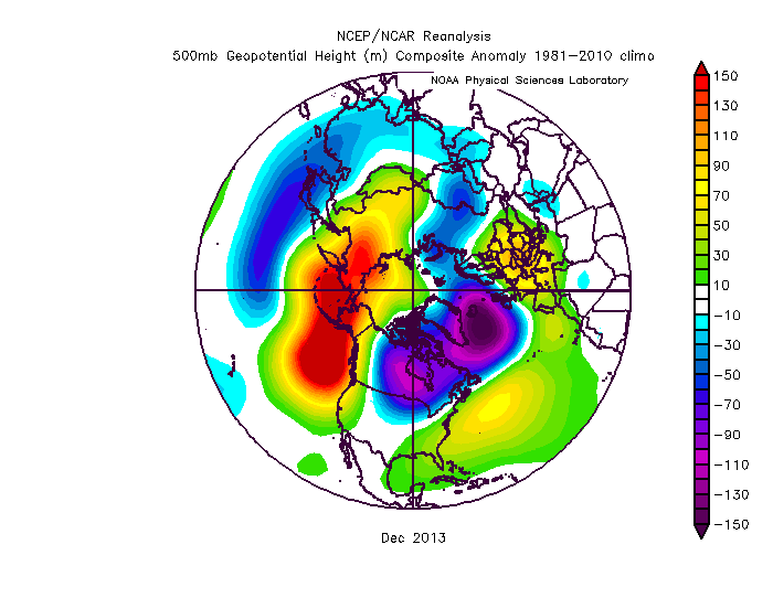
Even Dec 2013 wasn't exactly a Kocin Cookbook pattern, but we got walloped by a few storms that month
-
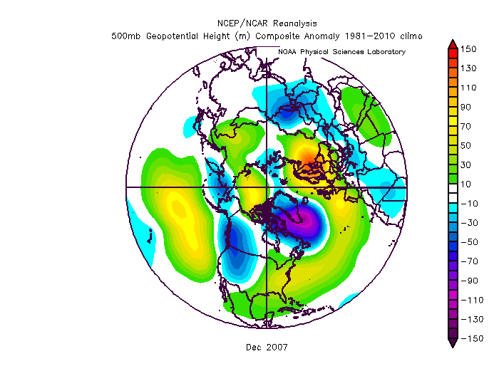
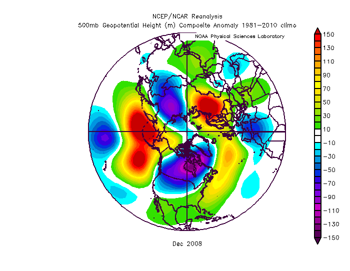
2008 was kind of similar too
-
Bummer, that puts all of New England out of the goods. There's always 2021-2022
-
Top 5 through 8/12 at all 4 sites....gonna lose ground though over the next week.
-
Lol, I was thinking the same thing.... Doesn't Kevin brag about wearing shorts when it's 45F? Now he needs to bundle up when its 59F.
-
I’d take the over at this point on 2035. We’ve basically had no trend in volume loss going back to 2010. You’d like to see something more discernible. Maybe there is another notable step-down currently in the works that will soon change the odds.
-
There's a lot of weak ice in the Beaufort/Chukchi region so I'd expect extent losses to accelerate again soon as a lot of that melts out and/or compacts, but we've lost any chance at a new record. I'm still expecting a top 3 lowest extent and area finish.
-
New England...where D0 and D1 conditions has everyone talking drought.
-
Euro seasonal is better than the others but in an absolute sense, it is still pretty inaccurate. It absolutely shit the bed last year even on the October and November versions IIRC. I also like to look at the H5 anomalies and not the 2m temp anomalies...they often don't seem in sync and the H5 anomaly forecast is going to be easier for the models to hit. IIRC, back in 2013-2014 and 2014-2015, it was showing these monster ridges over AK/EPO region (that largely verified) but they had warm anomalies in southern Canada and into most of the CONUS which is totally at odds with that pattern. So the H5anomaly was a lot more accurate for forecasting the sensible wx than the 2m temp anomaly.
-
Most of us hate high dewpoints in here. It’s a minority of posters led by DamageInTolland.


