

ORH_wxman
-
Posts
93,092 -
Joined
-
Last visited
Content Type
Profiles
Blogs
Forums
American Weather
Media Demo
Store
Gallery
Everything posted by ORH_wxman
-
Yeah the thing is, I can point to epic winters that had one up there in October. What do we say about it those times? It just isn’t very useful as a predictive measure imho. I’ll definitely be on the nervous train of it shows up in a sustained fashion deep in November. That’s where it actually seems to matter.
-
I remember running our true garbage dumpster fire winters one time and large majority of them had pigs in November for an extended stretch. Last year was actually an exception.
-
There’s basically no correlation. So some years are going to be good after an October piggy (see 2010 or 1995) and other years are going to stink. As for last year, we didn’t actually have a pig in AK in October. Maybe briefly but the mean was a ridge that month. I’d worry if it shows up in November...esp 2nd half of the month.
-
Not worried about piggies in October....we do start to worry in November. Esp the 2nd half of November.
-
This was another one that is in my top 5 or 10 that you throw your computer out the window on
-
It was almost certainly the 1/13/93 storm then. Pretty classic latitude storm setup. http://mp1.met.psu.edu/~fxg1/NARR/1993/us0113.php#picture
-
I still have that thing though I only use it as a backup now. Field and stream jacket that was given to me in fall 1996 when I was in high school. I gotta find those pics again. Lol. I’m actually wearing that jacket in pics I’ve posted on here of April ‘97 when I’m also wearing the early 90s patriots hat with the PomPom on top of it.
-
We share a lot of our favorite storms but this one is definitely polar opposites. That storm is my greatest weather memory and it would take something incredibly special to surpass it.
-
Was the second one the 3/24/93 event? There were other events that winter with a gradient but that one was really sharp. Very little fell south of about a Weymouth to Franklin line...it was a surprise event with marginal midlevels. Logan had like 8” and suburbs had 10”. Couldve been the 1/13/93 event too. That one had a very similar gradient. Really hit the pike region and northward good but not very much south. Lot of ZR over interior south of pike though.
-
This will magically undergo a metamorphosis and become “widespread 1-2 feet, and then Friday and Monday are 6-10 river-eastward” during winter.
-
We need to go back and find it...you were cussing out that 1/24 storm. You could feel the anger through the screen reading it.
-
No, MLK melt was 2010. It was a 2-parter. Round 1 was the bigger of the two parts. It was forecasted to be very marginal but the line literally set up along the MA/CT border. Even though you knew it was snowing up in ORH, you didn’t really melt down until the next day and the day after.... The next day after part 1, Megan posted pics of us hiking in the woods near us with fir trees draped in like 8” of paste and you absolutely lost it. Then the next day part 2 came through and you were expecting this one to probably be snow in Tolland and I actually was too...but then you reported that it was 33F and raining and wondering if it would flip to snow. As the hours passed, and it didn’t flip down there, I posted some pics of huge nickel/quarter sized flakes absolutely ripping in ORH with everything draped in another 3-4” or so and you went nuclear. Just a monster tantrum. It may have rivaled Scooter’s January 2015 tantrum right before the epic pattern crushed us. We’ll be telling our grandchildren about it.
-
The first few early season events are a novelty to track for a lot of the region regardless of IMBY effects, but we usually start ignoring posters like Powderfreak on the 3rd or 4th upslope event that affects a 10 square mile area. If it’s a bad winter in SNE, then posters like CoastalWx start becoming downright hostile.
-
A Randolph Ripper is what I will use in winter for snow events.
-
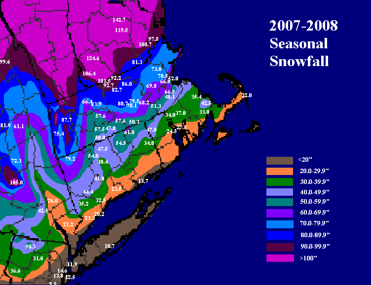
Yeah that was a fun one to draw up. I always say that I need to resume doing those but it’s hard these days with kids, lol. One of these years I definitely will though...unless some other entity beats me to the punch with detail and QC equal to or superior to what I set as my minimum standards. Anyways, here’s the 2007-2008 map again:
-
Maybe because Europeans don't care about TCs.
-
That was its "Brady Anderson 1996" season....randomly keeps hitting them out of the park that year and then regresses back to usual after that.
-
Yes it is....almost no decent Ninas had garbage Decembers. You usually want at least an average December. I'll be ORH-centric since it's easy for me to remember the years.....but garbage Nina Decembers for ORH are: 2011, 1999, 1998, 1988, 1984, 1973, 1955, 1954 I defined garbage as any December that was in the 30th percentile for snowfall or worse. So in this case for ORH, it would be like 7 inches of snow or worse in December. Of the list of years above, only 1955-1956 was good. All others were pretty horrific including the least snowiest season on record in 1954-1955. One other year in 1971 was a little bit outside the threshold at 9.6 inches in December. That Nina ended up being a blockbuster. Though just a few days before December started, the huge Thanksgiving 1971 storm hit, so there's another reason to be skeptical of thinking that year was going to bust. All those years I listed above also had garbage Novembers except 1955 (also the one year that didn't have a garbage winter out of that set....wonder if we should combine the two months when looking at Ninas?)
-
Common denominator of '95-'96, '05-'06, and '07-'08 were all 3 had very good or excellent Decembers. The pattern differed though in how we achieved it....1995 was a big -NAO block and 2007 was literally the opposite...a monster +NAO vortex that actually was displaced far enough southwest that it was acting almost like a block in and of itself and producing a big gradient in the east where it was a massive torch in the mid-atlantic/southeast and pretty cold in New England. 2005 was mostly PAC-driven western ridging, though the NAO wasn't hostile.
-
It did...seems like it's going to be operational now on other sites I guess. But it's still the RGEM at 60-84 hours, lol
-
Nice clipper redeveloper Miller B for 10/5 on the GFS....another 8 weeks later....
-
Still waiting for the epic pattern that the Euro seasonal had last winter.
-
Yeah I’m not a total expert on this stuff but from all the stuff I’ve read over the years, you want lots of cold (but not freezing) nights and sunny days. That was happening up until recently when the freezes happened...so perhaps there was enough sugar production to still get lots of reds/oranges from those previous “cold but not freezing” nights and the actual freeze is just going to act to shorten the season rather than have a large effect on dulling the colors.
-
Yeah maybe the freeze wasn’t bad enough to dull them much. I don’t know. Or maybe it would have been even brighter without the freeze. Hard to say. There’s obviously other factors too. We had a lot of cold crisp “near freeze” nights up north prior to the actual freeze, so perhaps that was enough to really juice the sugars in the hardwoods.
-
Early hard freezes tend to do both. Dulls the color some and shortens the season. That prob wouldn’t affect powderfreak’s mid-slope pics because they didn’t freeze I don’t think. They would actually get enhanced color because “near-freeze” nights and sunny days bring out more oranges and reds. But lower down it might be more noticeable. Doesn’t mean it cancels the foliage season...just makes it less and shorter than it otherwise would have been.


