ORH_wxman
-
Posts
93,092 -
Joined
-
Last visited
Content Type
Profiles
Blogs
Forums
American Weather
Media Demo
Store
Gallery
Everything posted by ORH_wxman
-
December 2021 Obs/Disco...Dreaming of a White-Weenie Xmas
ORH_wxman replied to 40/70 Benchmark's topic in New England
Perfect timing for indigestion over Quebec. -
December 2021 Obs/Disco...Dreaming of a White-Weenie Xmas
ORH_wxman replied to 40/70 Benchmark's topic in New England
Yeah this is gonna be cold...starts as snow in almost all of CT. -
December 2021 Obs/Disco...Dreaming of a White-Weenie Xmas
ORH_wxman replied to 40/70 Benchmark's topic in New England
There's a scooter shitstreak in Quebec that is helping shove it south still at 72h. -
December 2021 Obs/Disco...Dreaming of a White-Weenie Xmas
ORH_wxman replied to 40/70 Benchmark's topic in New England
Euro looks like it's getting a bit crunched south at 60 hours compared to 00z 72h....but we'll see for sure in the next few frames. -
December 2021 Obs/Disco...Dreaming of a White-Weenie Xmas
ORH_wxman replied to 40/70 Benchmark's topic in New England
That one had to be at least 1.5-2 inches. Some folks prob got 3"+. -
December 2021 Obs/Disco...Dreaming of a White-Weenie Xmas
ORH_wxman replied to 40/70 Benchmark's topic in New England
Pretty classic running into a brick wall there...you nearly have a closed 850 high sitting there just N of the US/Quebec border. -
December 2021 Obs/Disco...Dreaming of a White-Weenie Xmas
ORH_wxman replied to 40/70 Benchmark's topic in New England
Yeah you need to triple that....you're prob only accreting about 2 tenths of that when you consider both runoff and you lose some to sleet/snow on the front end. -
December 2021 Obs/Disco...Dreaming of a White-Weenie Xmas
ORH_wxman replied to 40/70 Benchmark's topic in New England
We probably need to triple the QPF for him to get his dream of a powerless Xmas. -
December 2021 Obs/Disco...Dreaming of a White-Weenie Xmas
ORH_wxman replied to 40/70 Benchmark's topic in New England
I can't take the swings on that model. It's infuriating. But I guess it nails the H5 pattern over the Galapagos Islands so we should treat it with respect. -
December 2021 Obs/Disco...Dreaming of a White-Weenie Xmas
ORH_wxman replied to 40/70 Benchmark's topic in New England
Ukie is coming in a lot colder too, but that model had parrots flying into ORH last night, so it's no surprise it's backing off after what we've seen already at 12z. -
December 2021 Obs/Disco...Dreaming of a White-Weenie Xmas
ORH_wxman replied to 40/70 Benchmark's topic in New England
Yeah it is typical in these events where the WAA aloft is stronger off to the west as opposed to a coastal that might be hugging the coast where the WAA is strongest in southeast areas. -
December 2021 Obs/Disco...Dreaming of a White-Weenie Xmas
ORH_wxman replied to 40/70 Benchmark's topic in New England
GGEM actually has the back-end snow that Scooter and I were discussing a while ago. Tries to pop a little conveyor as it exits and flips most of the region to snow (that wasn't already previously) for several hours. -
December 2021 Obs/Disco...Dreaming of a White-Weenie Xmas
ORH_wxman replied to 40/70 Benchmark's topic in New England
There's a crazy gradient for this thing to feed off of too....you have like +13C 850 temps down near DC while it's -5C to -10C from northern SNE into NNE. -
December 2021 Obs/Disco...Dreaming of a White-Weenie Xmas
ORH_wxman replied to 40/70 Benchmark's topic in New England
Scooter ripping fatties while Kevin is getting scalp-peeler on the GFS. -
December 2021 Obs/Disco...Dreaming of a White-Weenie Xmas
ORH_wxman replied to 40/70 Benchmark's topic in New England
12z GFS is coming in colder too. -
December 2021 Obs/Disco...Dreaming of a White-Weenie Xmas
ORH_wxman replied to 40/70 Benchmark's topic in New England
Starting to look pretty likely. -
December 2021 Obs/Disco...Dreaming of a White-Weenie Xmas
ORH_wxman replied to 40/70 Benchmark's topic in New England
Yeah the Euro suite/ensembles have been trying to pop this a bit before it exits and flip a lot of peeps to snow for a few hours. It looks like the NAM and RGEM may try to go that route if we had another panel or two....esp RGEM more than the NAM...RGEM was already collapsing the 925 low at the end. -
December 2021 Obs/Disco...Dreaming of a White-Weenie Xmas
ORH_wxman replied to 40/70 Benchmark's topic in New England
NAM is like -4C at 925mb along the pike....lol. That would be a scalp-peeling pelletfest here I think. Hoping for a tick colder aloft so it's more snow. -
December 2021 Obs/Disco...Dreaming of a White-Weenie Xmas
ORH_wxman replied to 40/70 Benchmark's topic in New England
There's a pretty good cold drain that may develop during the storm in the low levels. Could be the type of thing where it starts off as rain (or wet snow in northern SNE/CNE)...and then goes to a drier snow further north and pellets/ZR further south where there is still a warm layer aloft, but the cold drain in the low levels is undercutting that. -
December 2021 Obs/Disco...Dreaming of a White-Weenie Xmas
ORH_wxman replied to 40/70 Benchmark's topic in New England
RGEM is also colder than 06z....so we got NAM and RGEM ticking colder. -
December 2021 Obs/Disco...Dreaming of a White-Weenie Xmas
ORH_wxman replied to 40/70 Benchmark's topic in New England
Yeah there are similarities though the PNA is more negative and NAO not quite as west-based, but it's definitely a very favorable pattern. -
December 2021 Obs/Disco...Dreaming of a White-Weenie Xmas
ORH_wxman replied to 40/70 Benchmark's topic in New England
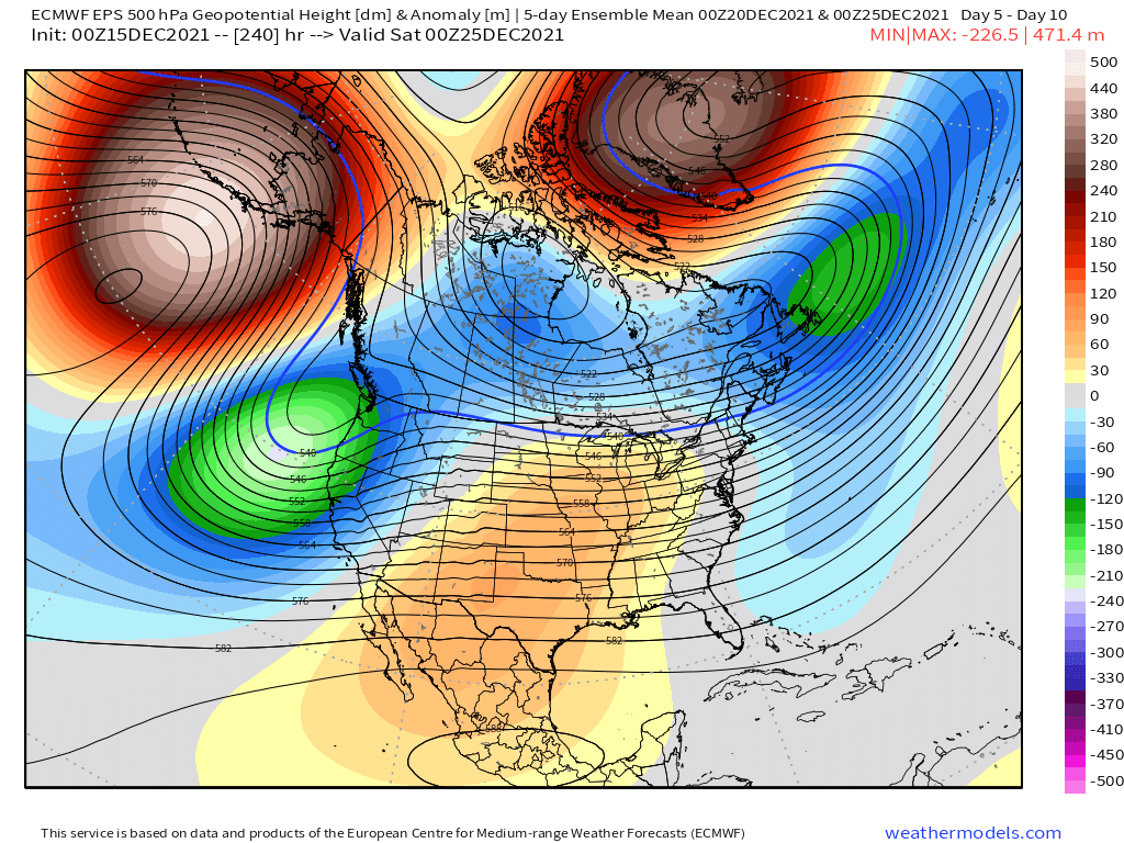
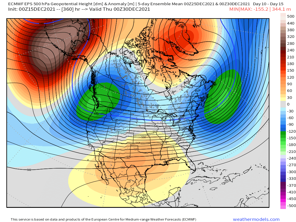
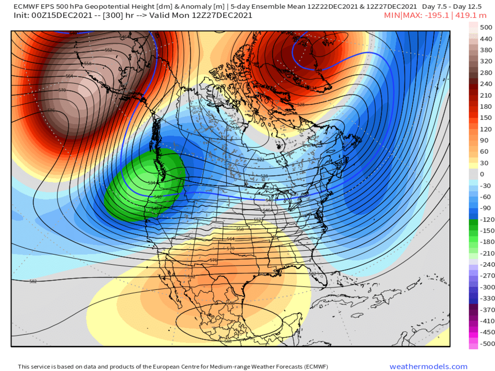
Long range pattern is pretty scintillating on guidance. Hopefully it sticks....because we're gonna cash in on that look if it does. 5 day means at Dec 25, Dec 27, and Dec 30.
-
December 2021 Obs/Disco...Dreaming of a White-Weenie Xmas
ORH_wxman replied to 40/70 Benchmark's topic in New England
There’s definitely room for a ribbon of sleet and ZR because the lower level cold drain is further south than the mid level cold. -
December 2021 Obs/Disco...Dreaming of a White-Weenie Xmas
ORH_wxman replied to 40/70 Benchmark's topic in New England
06z gfs did tickle south again. Euro suite is winning this battle so far. Let’s see if it can throw a shutout or if they win 5-2 or something. Makes a difference for us pike region folks. -
December 2021 Obs/Disco...Dreaming of a White-Weenie Xmas
ORH_wxman replied to 40/70 Benchmark's topic in New England
An inch wouldn’t last 3 or 4 days even in frigid weather. Not enough water content usually to stave off sublimation.