ORH_wxman
-
Posts
93,092 -
Joined
-
Last visited
Content Type
Profiles
Blogs
Forums
American Weather
Media Demo
Store
Gallery
Everything posted by ORH_wxman
-
We both feel that way because we're looking at a concentrated ball of strong vorticity rounding the base of that shortwave and then curling into E LI and the Cape. The stronger solution honestly makes meteorological sense...but we know convection-robbing of conveyors can be real, but we just don't when it is and when it's a model phantom.
-
The mid-levels have been lackluster compared to H5....if we increase the inflow just slightly, this will light up the QPF maps on model guidance....you can see it on the 3k somewhat.
-
Yeah the weenie band is prob like 06z to 10z or something and then things start collapsing SE quickly....the key for bigger snows out east is when that happens, do we see a potent little stinger develop and slowly push offshore giving 1-2" per hour for several hours?
-
It was still probably marginal warning snow over far eastern MA and SE MA....but it def was a little worse than 12z. It seems like we're starting to converge somewhat. I'd like to see a tickle west on GFS and Euro though to be more confident of warning snows in eastern MA/RI.
-
https://collaboration.cmc.ec.gc.ca/cmc/cmdn/pcpn_type/pcpn_type_gem_reg.html
-
18z RGEM is ticking east
-
That's a hell of a stinger to end the event over eastern areas on the 3k...that would be a fun morning rush hour.
-
Yeah 00z tonight is kind of the big showdown...should get another good sample of the shortwave on the KTFK and KRIW launch sites too.
-
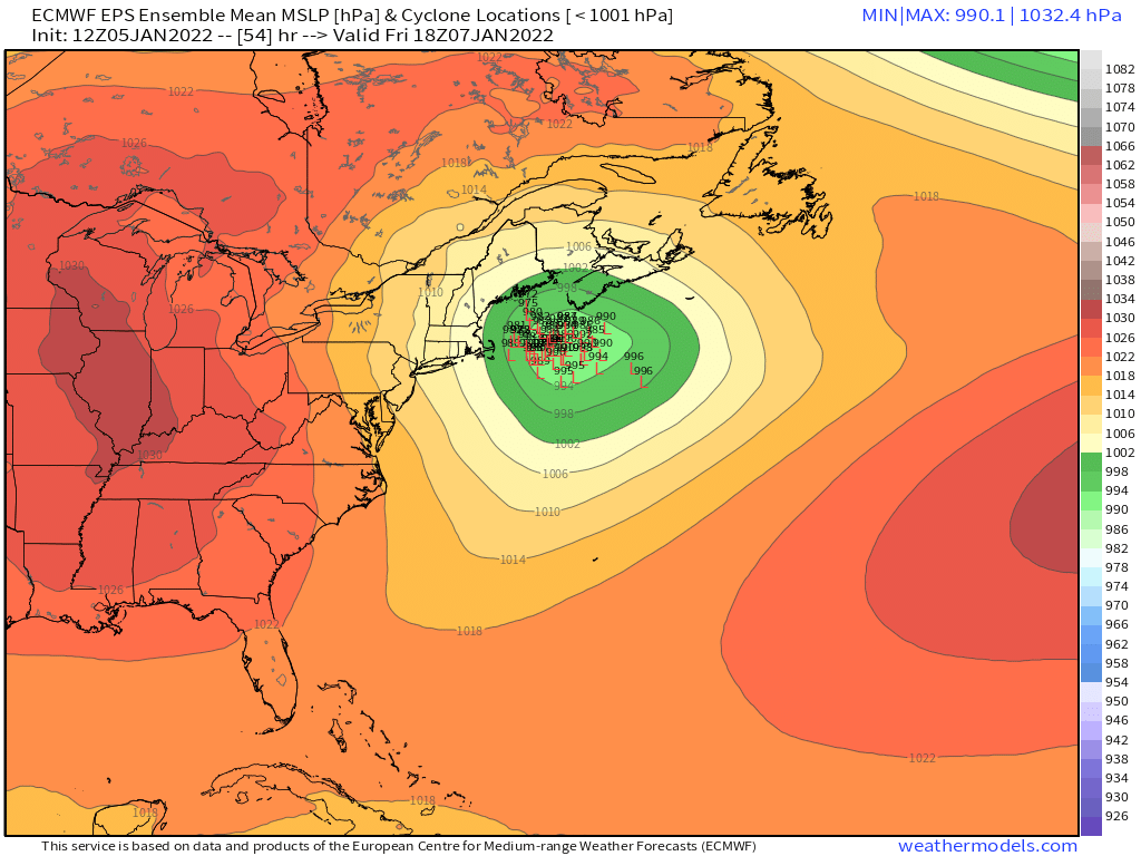
Better than 12z....now that is what we want to see.
-
Yeah it's trying, biut not quite enough this run to deliver the real goodies....still a better look at least than 12z. Most of my hope in this system is due to the strong vortmax....that as we get closer and closer, the model guidance will be focusing more of the forcing along the track of that vortmax and not to the east.
-
It's def better than 12z by 39 hours...the stronger vortmax is offsetting the earlier trend of lower heights over us. It's pulling the system back in closer to the shortwave.
-
The vortmax is actually a bit more potent this run, so its going to try and gain back here late in the game.
-
Might be some bridge-jumping this run....it looks even flatter than the clunker 12z solution.
-
I'll add that H85 is 850mb....it's not someone fat-fingering H5 (usually, lol)
-
We take...

-
It's a marginal watch....though for SE MA, it's probably close. You only need 50% confidence of 6" for a watch and they are probably pretty close to that in SE MA. I'd prob wait until tonight personally, but given that there hasn't been any real snow yet this winter and that it will fall during Friday rush hour there, I can see hedging slightly more aggressive.
-
2000s/2010s for sure....but he's not wrong about the clown maps. The clown maps are cringe....admittedly fun to look at, but they shouldn't be used beyond entertainment unless you know they are actually representative of the system (which most will not know).
-
The EPS still have a westward skew, but the variance is getting pretty tight now.

-
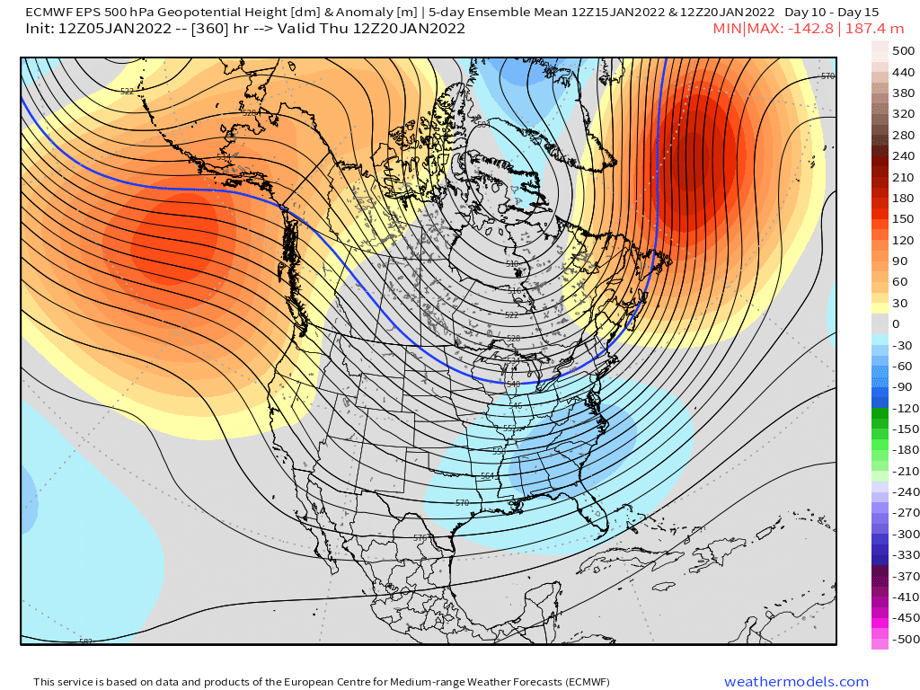
Clown range Euro is cooking up a monster....clown range as it is, but ensembles have also been hinting at that mid-month period for something bigger.
-
I think those probs are too low in eastern areas. Like I think SE MA def has more than a 10% chance of 8"....maybe not WAY more, but I'd prob put the chances more like 25-30% there. It will prob only take about a half inch to 6 tenths of QPF to get 8" there and there are several pieces of guidance that give that.
-
It looks more like N ATL ridging rather than true blocking....though there's some hints of it trying to form a block in Greenland/Davis Strait, but even N ATL ridging can be useful. The GEFS are definitely more bullish on any of that getting back into Greenland/Davis strait than the EPS. The EPS was more just straight N ATL ridging.
-
Usually I like to compare to the last cycle....but this system definitely has some weird off-hour/on hour tango dance going on.
-
This definitely looks like some midlevel goodies...most of us are obviously still rooting for the 0.75-1.00 QPF slamming on Atlantic inflow, but aside from that, it's probably going to be nice snow growth in the ML banding that is consistently being signaled over SNE. Even like a 13 or 14 to 1 ratio will give 4" on a quarter inch qpf...and it's possible ratios are a bit higher inside a decent band.
-
He has to stay on brand...just slice off a couple inches.
-
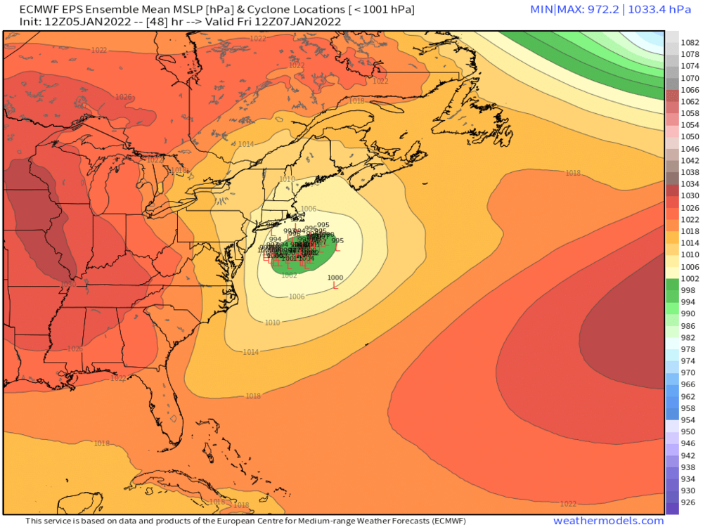
Actually you posted 06z vs 12z....i was talking 00z vs 12z. 06z was definitely better than 12z.