ORH_wxman
-
Posts
93,092 -
Joined
-
Last visited
Content Type
Profiles
Blogs
Forums
American Weather
Media Demo
Store
Gallery
Everything posted by ORH_wxman
-
Did you originally have November really cold? It looks pretty damned cold across the CONUS 2nd half of the month (N plains and Rockies almost the whole month). Might just have to back your timing up. Things could always change of course. Maybe model guidance is too bullish on cold later this month.
-
Yeah let’s back that west about another 75-100 miles. 12-15” for ORH hills? Can always adjust up if needed.
-
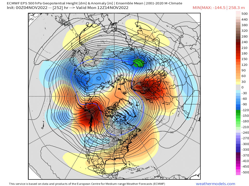
Some guidance showing potential for first winter threat near mid-month? Both Euro and GFS trying to show it…though via different mechanisms.
-
‘02-03 was pretty awesome from a length standpoint. We started in October that year (3 inches at ORH on 10/23/02) and then had 3 November events (snow to sleet to ice on 11/16-17), 6-10” on 11/27 day before Tday, and then 1-2” a couple days later with the warm front lifting back north… Then of course Dec/Jan/Feb were great (a little less so along coast Dec/Jan), and then we even had that frigid week in April 2003 that produce a couple snow events. And it was a really cold winter as well. Underrated for cold.
-
Those are November composites. Not winter.
-
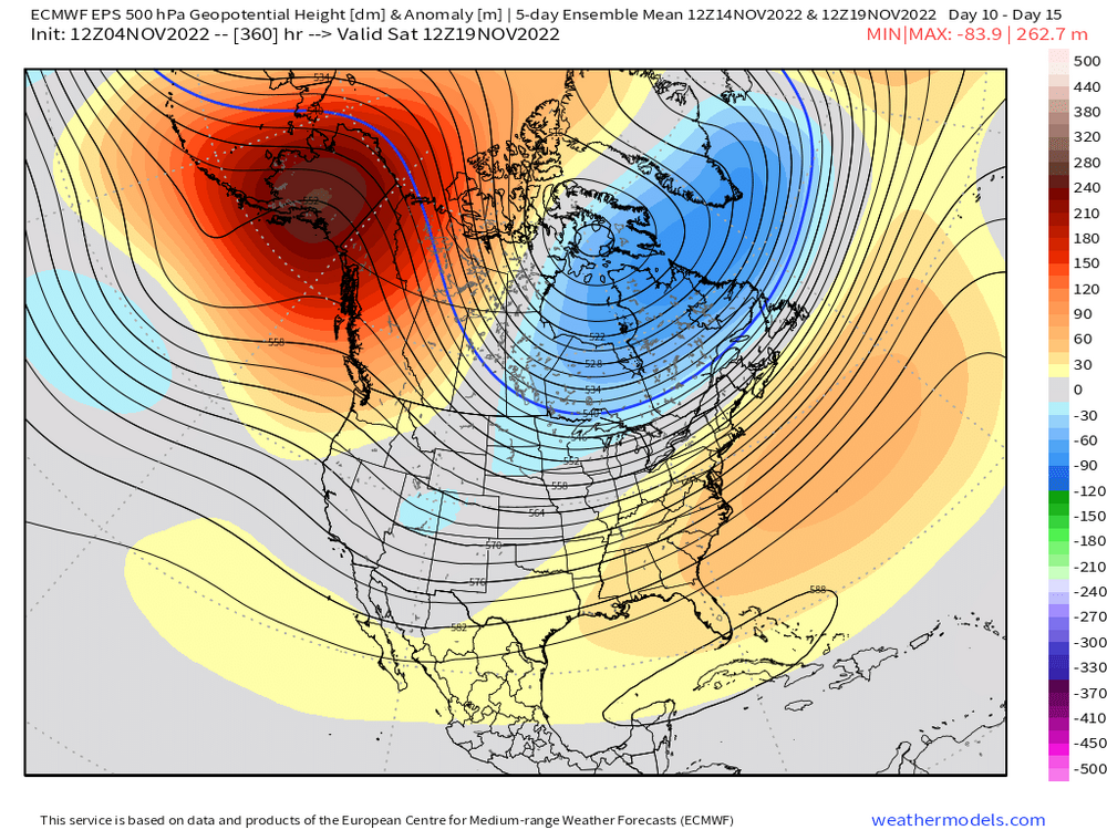
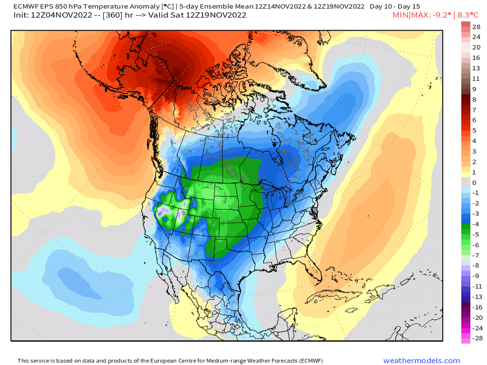
That doesn't look like a bad forecast for this November either. We're going to prob finish above normal here because the first 10 days are so warm, but it could get close if we have a cold 2nd half. Plains and N rockies will be frigid.
-
Yeah nice look on the 5-day mean anomaly.....that's a ton of cold in the plains and Canada (and cold over us, just not overly frigid)
-
EPS trending colder too toward mid-month. It's more poleward and further east with the AK ridging.
-
Mar '03 was below average here in snow....though not sure down where you are. You might have been closer to normal with the 3/6/03 event doing better south.
-
Trying for the more -AO near the end? That would be nice to have with the -EPO.
-
-
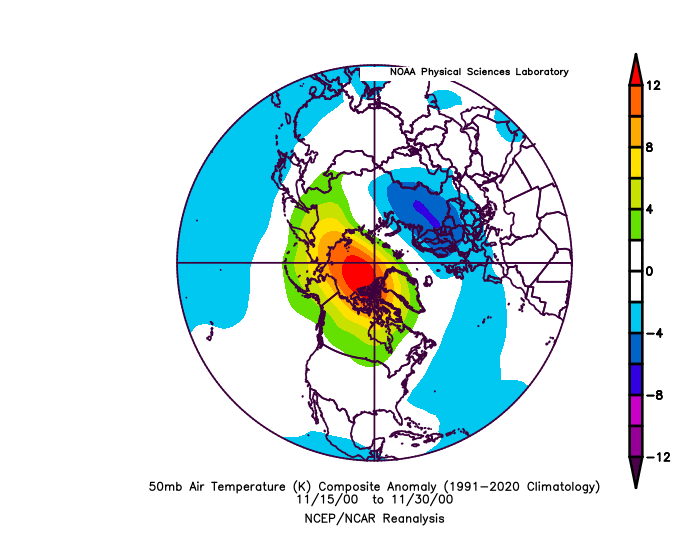
Relationship is kind of weak, but all else equal, you like to see the warm anomalies in the stratosphere in the eastern portion (toward Bering) of Siberia in mid/late November. 50mb charts show that which is good. That has historically meant a better chance for blocking. But like some of these other stratospheric and blocking relationships, I wouldn't weight them too much.
-
Yeah I'd love to have snow the last week of the month, but everyone knows the climo....there's a reason most of the forum outside the elevated areas of CNE/NNE average between 1-4" in November. it's a really good sign that there is no sign of the AK pig returning. That's the biggest thing I'm following.
-
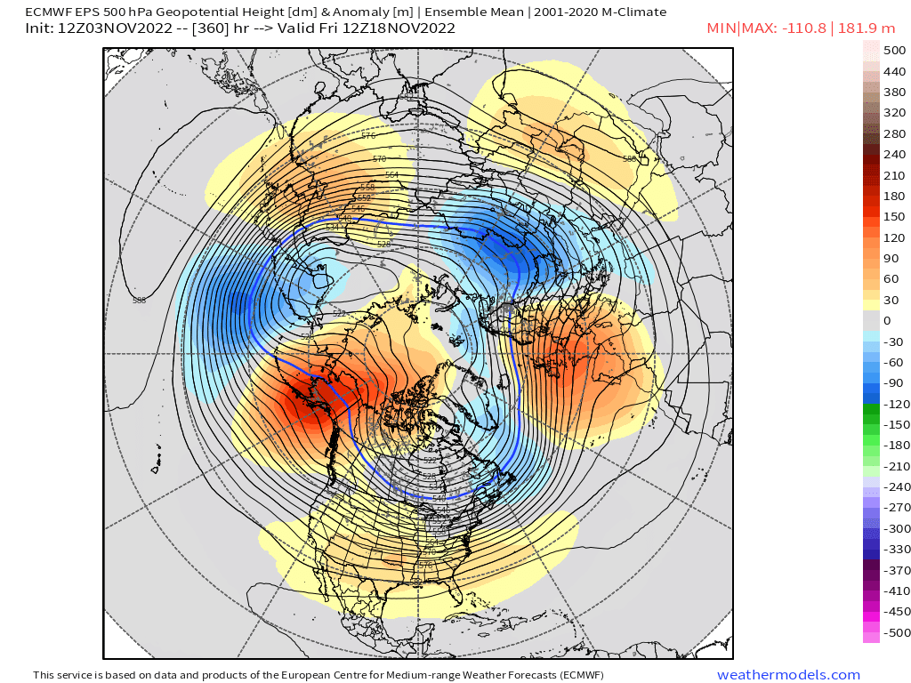
Yeah sometimes the weeklies lag the EPS by a cycle....I've noticed that. The EPS just recently went more ridging in the PNA region and that is what the weeklies weren't showing. You can see how EPS is hitting that EPO/PNA ridge....weeklies don't show this as much

-
Weeklies love December, but they keep 2nd half of November pretty meh. EPS are a lot more bullish on colder weather for mid-month and beyond.
-
The world cup is on Superstar....that's the trail that stays open until June some years.....so most of the snow will be man made. But even making snow will be very limited....only that small window. They'll have to cover it good. At least most of the week will be dry...so dry with low sun angle should help keep the snow intact. It will just need to withstand the FROPA rains next weekend which will be high dews.
-
I think the only window is Monday night through Tuesday night.
-
They better get a ton of snow down in the "cool shot" early next week....not even sure how much they can make but if they don't make it then, there's literally no way they can make any prior to 11/12. The irony is the pattern looks pretty good for them to make a ton of snow after that.
-
That strong pulse of lower heights SW of Aleutians showing up late in the run is interesting.....could mean a pretty huge EPO/PNA joint ridge extrapolating toward late November which is what some of the seasonal guidance was showing. Regardless, the AK heights have been consistently well above avg on all ensemble runs after this week.

-
I think about 2/3rds of the forum would be.
-
Yeah not sure why some reactions are the way they are....but regardless, the weather doesn't give a shit. It's not going to flip from excessive warmth to excessive cold on a dime either. It prob goes more closer to normal for a bit and then if western ridging takes hold, that's when we'll see a better chance as sustained below normal temps.
-
Its pretty hard to argue against a pattern change when we're going from a huge AK pig currently, to a -EPO with initial dump of cold out west (while we continue to torch), and then eventually the EPO rolling over on itself and ending the furnace here. You can argue whether that means first snow chances or just merely chillier/normal weather for mid/late November, but it's a far cry from what we've seen and what we're going to see for the next week to 10 days.
-
12/29 was pretty huge but only in a narrow zone from N RI to metrowest BOS suburbs where several places had 18"+.....we just lacked a region-wide big dog. Jan '77 had some SWFEs on 'roids and a late bloomer miller B, but still not high end top 10 type stuff.
-
Yeah that's why I want it in early/mid December when the climo is more precarious. Gives us more wiggle room. Later December into January we can still do ok in a lot of flawed patterns as long as we are avoiding the AK pig.
-
Forgot about '76-77 too....prob pulled it off in your 'hood. ORH fell just short because of December. But 12/29/76 crushed the 128 belt out east.