ORH_wxman
-
Posts
93,092 -
Joined
-
Last visited
Content Type
Profiles
Blogs
Forums
American Weather
Media Demo
Store
Gallery
Everything posted by ORH_wxman
-
It certainly could be cold and snowy....but we're just saying that the beginning of the month looks like it's going to be milder....it's been in the cards for a while to varying degrees. A few recent runs had the relaxation almost disappearing but it's come back on the last run or two.
-
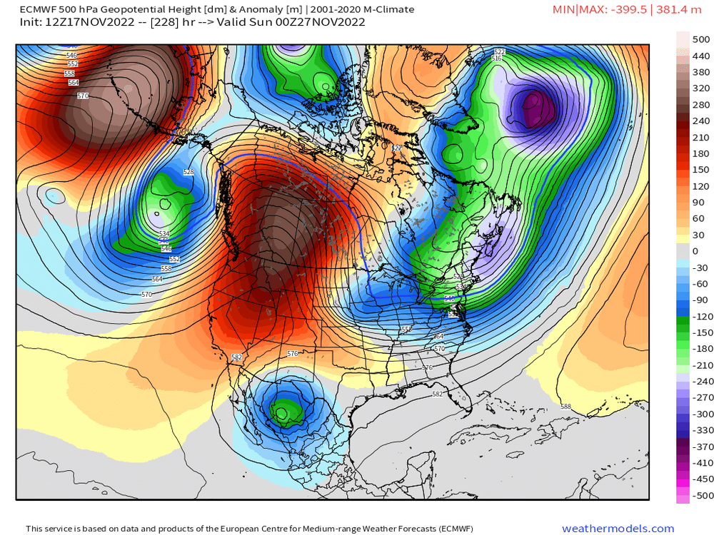
N PAC looks like it gets pretty hostile in early December on EPS.
-
Early in the season. People are anxious to get things rolling 3 weeks ahead of climo. It’s a pretty nice look for late November, but you still need a lot of things to line up. There will likely be more chances into December though with this pattern. Looks pretty active.
-
Yeah but a lot of them have no cold air in place because that PV lobe never makes it south. There’s some members on the benchmark with a rainstorm.
-
There’s some good members in there still. But whatever the OP saw at 18z, a decent number of the ensembles saw too. But it might mean nothing…one of the pet peeves I have is the ensembles sometimes follow the OP too much in the medium range. We’ll know a lot more in the next few runs. There’s a reason we see so few big snows in November. You need a lot of things to go right.
-
Not really. GEFS trended way north with the PV lobe too. Just not as much as the OP.
-
It’s like an 800 mile shift in the PV lobe. And that was before the storm. Only like 6 days out. I expect shifts at d6 but usually not that big. Lol. We’ll see what ensemble say in a bit.
-
Difference between the 12z and 18z. Look north of us. Completely different.
-
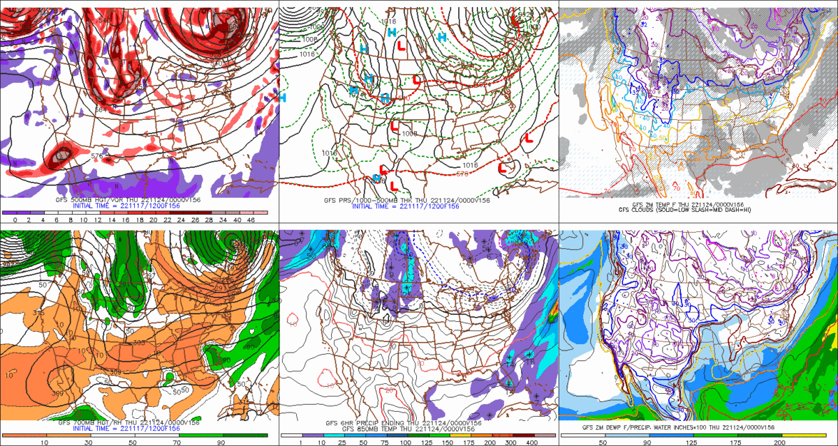
GFS never gets the cold airmass in here for Tday. That’s a requirement for any threat to produce winter wx. Looks almost like the euro from 3-4 runs ago when it never pressed the cold south and kept us mild for Tday.
-
I get that November has winter vibes with the low sun angle and shorter days plus the holidays starting up…if it were up to me, we’d all be buried by Tday. But unfortunately the weather doesn’t care. The numbers don’t lie. When it comes to weather, November is quite anemic as a winter month.
-
They do have a nice -NAO early/mid December though. Hopefully that verifies and then takes longer to break down than it is forecasting. Also, the weeklies are initialized at 00z, so they are prob not seeing some of this 12z stuff which seems to be a bit better looking out west.
-
It's too bad the weather doesn't cooperate though.....
-
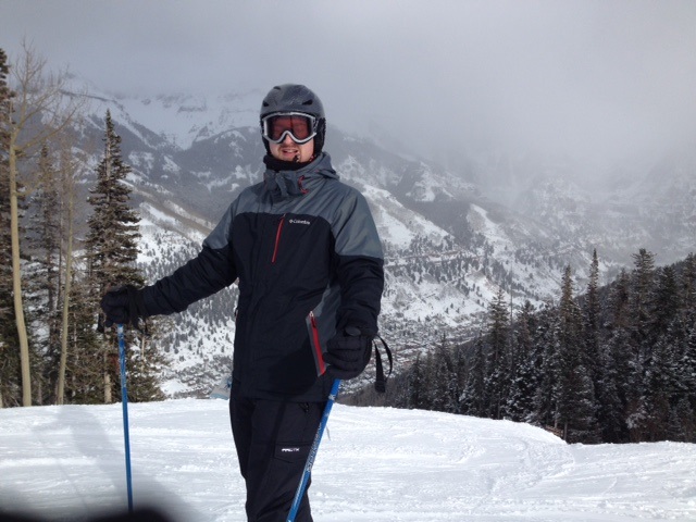
Yeah I flew into MTJ as well....it's super easy from there. Took a shuttle van and the dude got us there in just over an hour. It's an extra bonus that you found it cheaper than DEN. MTJ is so convenient, I'd prob pay like a $100 premium to fly into there. One of my fav pics from my 2016 trip is when the skies temporarily cleared right after a snow shower/squall and it was right before I skied down the north face. Great view of the town behind me down below. Not sure there any bad views at that place TBH.
-
March 25th has colder normals than November 17th at ORH....do you consider March 25th winter? March 25th also averages a lot more snow than Nov 17th in addition to being colder.
-
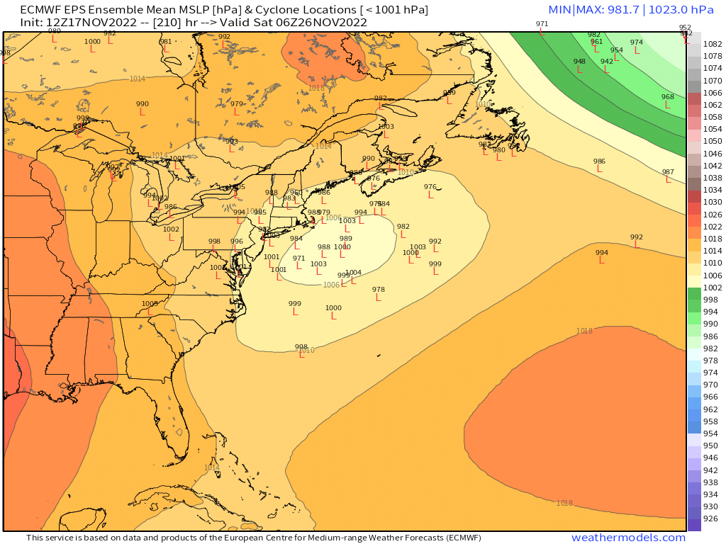
The only ugly week on the weeklies was Dec 19-26......we know that will verify too.
-
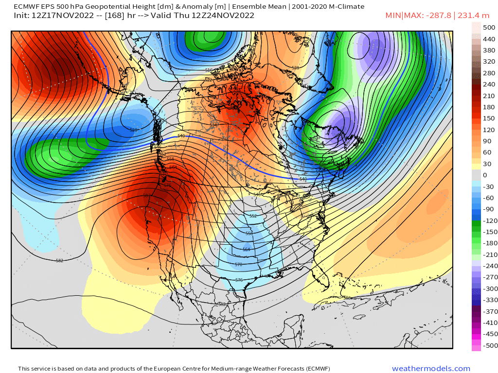
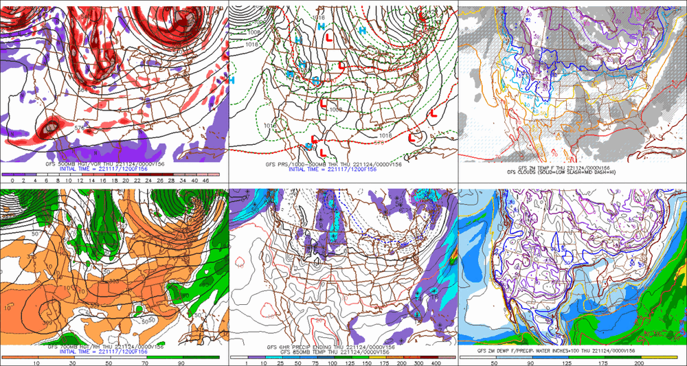
The table is set by D7 on the EPS....you can see all the key synoptic features....the 50/50 low producing confluence to our north, the shortwave over the central US, a stout western ridge, and solid -NAO to hold the 50/50 in place longer as the shortwave approaches. All very good to see. Obviously we need to get this about 2-3 days closer to take it really seriously, but you'd rather have this general look than not right now

-
Yeah, EPS totally not biting on burying the energy....a lot of solutions that look good

-
Look at the western ridge now at d9. Lol. Might produce a totally different storm. Euro buries all the energy in the southwest so that still bears watching. But even without that, it’s a pretty ripe pattern.
-
Smoked on the north ridge cam (time sensitive) https://www.killington.com/the-mountain/webcams/mountain/north-ridge-cam
-
Long drive from Frisco to Telluride. But if you can stay in Telluride for a few days, it's def worth it. If its only for a day or two in Telluride, I'd prob just enjoy Copper and not worry about the 5-6 hour drive.
-
Depends how high in elevation you are talking.....above like 2500 feet? Probably a whole bunch. They prob get one every few years. But at like 1200-1400 feet? My guess is maybe a few extra beyond the ORH storms, but not a whole lot more. Maybe like 7 or 8 instead of 3? I'm pretty sure the 11/19/86 storm got double digits on east slopes. Also the 2014 T-day Eve storm I think gave them close to a foot. There's probably a few more in there where ORH got like 8" but they got 11" or something like that. Nov 1980 maybe....also Nov '61 and maybe Nov '44.
-
It's almost impossible to get advisory snows along the coast in SNE during November without a good high placement. I had a thread on this back on eastern that analyzed all the advisory events (or better) for BOS in November and I think every single one had a good high in place except maybe one which was a ULL/cutoff that changed to snow near the end and dropped like 3 inches. Warning snows are even harder. Even for a place like ORH at 1000 feet in the interior, it is not easy to get big dog snows in November. In fact, in 130 years of records, ORH has exactly 3 snow events of double digits in the month of November....Nov 26-27, 1898, Nov 25, 1971, and Nov 10-12, 1987. There's been a fair number of warning events, but most of them are in the 6-8" range. Most recently 8.2" on Nov 15-16, 2018.
-
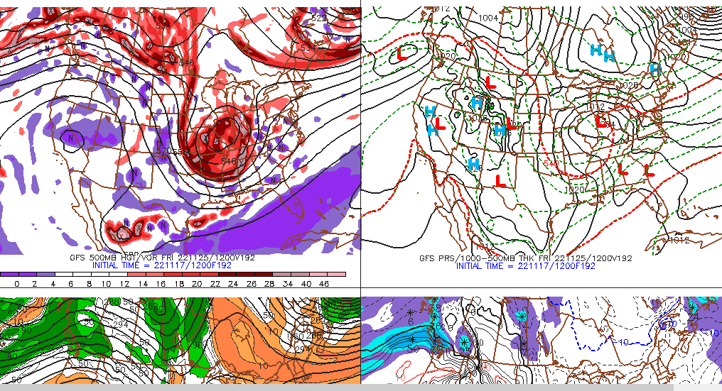
I mean from a pure synoptic standpoint, it doesn't get more classic than that look....you have the confluence to our north from the 50/50 low...split flow over central Canada and a very powerful cutoff shortwave in the OH valley with a western ridge to give it a little room to dig....too bad it's 8-9 days out

-
That shortwave is on 'roids....could be a crazy solution. 8-9 days out though.....
-
Trough digging too much that run anyway....gonna spawn a low near Houston, lol.